Archive for the ‘Mill Ruins Park’ Tag
Friday Photo: Before the Mills Were Ruins
Filed under: Mill Ruins Park, Minneapolis Parks: General, Mississippi River | Tags: Mill Ruins Park, Mississippi River, Stone Arch Bridge
 Comments (8)
 Let’s go down to the river one more time. I have many favorite pictures of the riverfront when it was the economic engine of Minneapolis, but this is probably at the top of my list.

The west bank of the Mississippi River in downtown Minneapolis, just below St. Anthony Falls, in 1885. (Minnesota Historical Society)
You can see just a dash of the still-new Stone Arch Bridge on the right margin of the photo. The channel here is all tail race — the water that ran out of the mills after generating power.
My favorite part of this photo though is the trestle and railroad tracks that ran between the mills and the river at essentially the level of city streets. Those tail races coming out of the mills are now a part of Mill Ruins Park. The trestle and tracks are gone, but I don’t know when they were torn down. Anybody?
Below are two shots (a 3-for-1 Friday Photo!, the biggest Friday Photo discount ever) of the tail races as they appeared probably in the 1950s.

Tail races, some of which are now visible in Mill Ruins Park. (MPRB)

A closer look at the trail races and water returning to the river after its work was done. (MPRB)
Both photos are undated. They show the water coming out of the tail races. They give a much better sense of the management of water power. I’m not sure of the functions of structures and workers at this point in the water power process.
These structures were razed and covered when the Upper St. Anthony Falls Lock and Dam was built in the 1960s.
For a marvelous 360-degree panorama of Mill Ruins Park and the adjacent lock and dam go here, courtesy of the National Park Service. Learn much more about the lock and dam — one of the biggest mistakes Minneapolis and the U. S. Army Corps of Engineers ever made — at the pages of the Mississippi National River and Recreation Area.
Have a look around the park — if spring ever comes. The transformation is amazing — and thought-provoking.
David C. Smith
© Copyright 2013
Friday Photo: West Riverbank from the Stone Arch Bridge
Filed under: Mill Ruins Park, Minneapolis Parks: General | Tags: Mill Ruins Park, Stone Arch Bridge
Leave a comment I don’t want to overdo the Stone Arch Bridge, but will run that risk with this photo found by Andrew Caddock at the park board. I showed the picture recently to a group of local history buffs and asked for guesses on when it was taken. Guesses ranged mostly from 1930-1960s. The real answer is ….
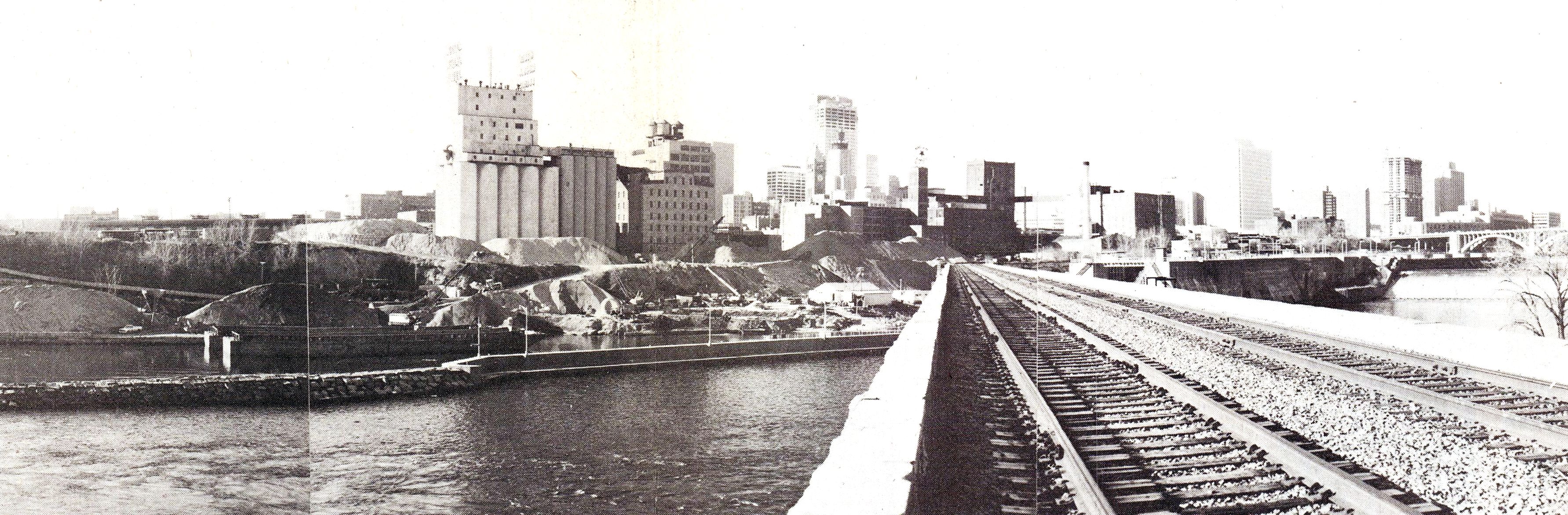
View from the Stone Arch Bridge. Click for larger image. (Jim Keane, Riverfront News)
…1980. Not that long ago.
The piles of sand and aggregate in front of the old mills were used to make concrete and were owned by Shiely Co. The materials were mixed on site and used in downtown construction projects; the sand and gravel could be transported at much lower cost by barge than by truck. The company first used the area for aggregate storage when it was making the concrete to build the upper lock and dam — on the right of the bridge — which was completed in 1965. Train traffic on the Stone Arch Bridge had stopped a couple of years before this photo was taken.
The photo appeared in the December 1980 issue of Riverfront News, a publication of the Minneapolis Riverfront Coordination Board, which included representatives of the major agencies of Minneapolis government.
The land under the sand piles is now Mill Ruins Park. The Guthrie Theater would be near the left edge of the photo
David C. Smith
Friday Photo: How A Stone Arch Was Made
Filed under: Minneapolis parks, Mississippi River | Tags: Father Hennepin Bluffs, Mill Ruins Park, Stone Arch Bridge
Comments (5) The Stone Arch Bridge over the Mississippi River in downtown Minneapolis is becoming one of the iconic images of the city. Have you ever wondered how those arches were made? I have. So I found this photo of the bridge under construction. The deck of the bridge is maintained by the Minneapolis Park and Recreation Board, so let’s call it a park. Day and night the bridge provides the best views of the city. A hike over the bridge between Mill Ruins and Father Hennepin Bluffs, in either direction, is a must for visitors and residents.
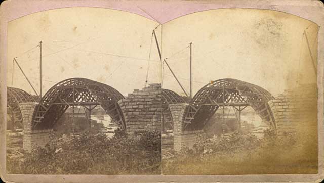
This stereoscope image shows the stone arches being built over forms in 1883. (Henry Farr, Minnesota Historical Society)
The two-track railroad bridge was being built at the time the park board was created in 1883.

The Stone Arch Bridge being completed in 1883. (Burlington Northern, Minnesota Historical Society)
This is another favorite shot of the bridge as it neared completion
David C. Smith

