Archive for the ‘Minnehaha Falls’ Tag
Minnehaha Rails
Filed under: Minneapolis Parks: General, Minnehaha Falls | Tags: Bureau of Mines: Twin Cities Research Center, Minnehaha Falls, Minnehaha Limestone Quarry, Mississippi National River and Recreation Area
 Comments (10)
 Rene Rosengren recently sent some photos of metal rails she found south of the Minnehaha Off Leash Dog Park just off the Minnehaha Trail. Any ideas what they are?
I’ve written about the limestone quarry at Minnehaha Park that was operated for just one year by the park board in 1907, but was reopened by the WPA from 1938-1942. I think these tracks are too far south to have been part of that quarry, but the narrow gauge suggests that they were part of a quarry or similar extraction enterprise.


I suspect the tracks were once a part of the Bureau of Mines Research Center on federal land that is now owned by the National Park Service as part of the Mississippi National River and Recreation Area.
Rene and I would be happy to hear any thoughts on the narrow gauge tracks.
David Carpentier Smith
Charles Loring: “We must control the lake.”
Filed under: Loring Park, Minneapolis Lakes, Minneapolis parks | Tags: Charles M. Loring, Florence Barton Loring, Lake Calhoun, Lake Harriet, Lake of the Isles, Minneapolis parks, Minnehaha Falls
Comments (3) If you have read my history of the Minneapolis park system, City of Parks, you may recall that Charles Loring’s efforts to acquire land around lakes Harriet, Isles and Calhoun remain a subject of speculation. No one has ever found a clear strategy or well-documented plan by Loring, the first president of the Minneapolis Board of Park Commissioners, to acquire the lakes, even though he spent the better part of several years in getting those complicated real estate deals done. I focused mostly on Loring’s desire to create a parkway from Loring Park, then still called Central Park, around the lakes to Lake Harriet, which had been acquired already for the fledgling park board largely by gift. Even the generous gift of land around Lake Harriet by Henry Beard, James Merritt, Charles Reeve and, ultimately, William King, was prompted by the desire to have a parkway around the lake, which accounts for the limits of the original gift: a strip of land only 125 feet wide around Lake Harriet—just enough for a walking path, a carriage way and a few trees or flowers to dress it up.
A new discovery suggests, however, that Loring had much more in mind than parkways. As part of the ongoing project to inventory the park board’s historical records with the goal of making them more accessible to researchers, I recently found a letter written by Loring in 1886 that sheds more light on his thinking about the lakes.
The letter, dated June 14, 1886 and addressed to park board secretary Rufus Baldwin, discusses Loring’s views on what needs to be done to acquire land at Lake of the Isles. Loring notes that Alfred Dean, who owned much of the land that had to be crossed by a parkway at Lake of the Isles, had already told Loring he could do whatever he wished. Loring then wrote,
“My opinion is that we do not want the land on the outside, but do want it next the lake. As the plat now is, the boulevard goes around the little marsh thus.”
Loring then includes a small drawing.
Charles Loring’s letter to Rufus Baldwin, June 14, 1886
He is very explicit, writing on the road next to the lake “This is what we want” and concluding bluntly, “We must control the lake.”
This evidence that Loring was thinking far beyond parkways is reinforced by the concluding page of his letter when he addresses a new topic: boats on Lake Harriet. He notes that a steamer has been placed on the lake and he has asked the owner to remove it, but adds that after talking with “Judge Fish”—park board attorney Daniel Fish—Loring doesn’t want legal questions raised yet about “rights on the water”. Clearly, Loring is thinking about park board control not just of boulevards around the lake, but activity on the lake as well. His earlier comment, “We must control the lake”, takes on even greater significance.
We may owe even more to Charles Loring and his vision than we previously knew.
While on the subject of Loring I want to mention a note I received a while ago from, William Scott, the great-great-nephew of Charles Loring’s second wife Florence Barton Loring. You can read more about his family’s relationship with the Bartons and Lorings in the “Comments” section here.
This is the carte de visite of Florence Barton that he refers to. Thanks to William Scott for sharing the photos below.

Florence Barton, date unknown. (Beal Art Gallery, Harold W. Scott Collection, courtesy William Scott)
This must have been taken long before she married Charles Loring at age 45 in 1895. Read much more about Florence Barton Loring here.
William Scott also sent a photograph of family and friends at Minnehaha Falls in about 1910. Love those hats! The new bridge with the boulder face over a concrete structure was brand new in 1910. Appears to be a dry year.

David C. Smith
© 2016 David C. Smith
Hiawatha and Minnehaha Do Chicago
Filed under: Minneapolis parks, Minnehaha Falls | Tags: Daniel Chester French, Hiawatha and Minnehaha Statue, Jakob Fjelde, Minnehaha Falls, Ole Bull Statue, William Watts Folwell
Leave a comment The World’s Columbian Exposition in Chicago hosted the debut of Minneapolis’s most famous sculptural couple, Hiawatha and Minnehaha, in 1893.
The Minnesota building at the World’s Columbian Exposition in 1893 featured Jakob Fjelde’s sculpture of Hiawatha and Minnehaha in the vestibule.
Zoooom.
Hiawatha and Minnehaha greeted visitors to the state’s pavilion in their modest plaster costumes nearly two decades before sculptor Jakob Fjelde’s pair took their much-photographed places on the small island above Minnehaha Falls in their bronze finery in 1912.

Hiawatha and Minnehaha in their customary place above Minnehaha Falls. This photo, from a postcard, was probably taken in the 1910s. I chose this picture not only because Hiawatha appears to be climbing a mountain of rocks to cross the stream, unlike today, but also because it is a Lee Bros. photo, the same photographers who shot the photo of Fjelde below.

Jakob Fjelde, Lee Bros., year unknown. I like the cigar. (Photo courtesy of cabinetcardgallery.wordpress.com)
Jakob Fjelde was largely responsible for two other sculptures in Minneapolis parks. He created the statue of Ole Bull, the Norwegian violinist, in Loring Park in 1895. He also created the drawing that Johannes Gelert used after Fjelde’s death to sculpt the figure of pioneer John Stevens, which now stands in Minnehaha Park. Fjelde also created the bust of Henrik Ibsen, Norway’s most famous writer, that adorns Como Park in St. Paul. Fjelde’s best-known work other than Longfellow’s lovers, however, is the charging foot soldier of the 1st Minnesota rushing to his likely death on the battlefield of Gettysburg.

Fjelde’s simple commemoration of the sacrifice of Minnesota men at a pivotal moment in the Civil War. The sculpture was installed in 1893 and dedicated in 1897. (Photo: Wikipedia)
These thoughts and images of sculpture in Minneapolis parks were prompted in part by my recent post on Daniel Chester French, but also by another letter found in the papers of William Watts Folwell at the Minnesota Historical Society. Just two years after Fjelde’s successes with his sculptures for Gettysburg and Chicago, he wrote a poignant letter to Folwell in July 1895 seeking his support for an “extravagant” offer. Fjelde proposes to the Court House Commission, which was developing plans for a new City Hall and Court House, that he create a seven-foot tall statue of the Chief Justice of the U.S. Supreme Court, John Marshall, and a bronze bust of District Court Judge William Lochren, both for the sum of $1,400. Fjelde calls the price of $1,000 for the Marshall statue “1/3 of its real value.” He explains his offer to Folwell:
“Anyone who knows a little about sculpture work will know that the sums above stated are no price for such a statue but as I for the last six months have been unable to get any work to do at all and have wife and four children to take care of and in spite of utmost economy, unable to make both ends meet, I am obliged to do something extravagant, if only I can get the work to do.”
Fjelde adds that $400 for a bronze bust of Lochren would only pay for the bronze work, meaning that he would be creating the bust free. He writes that he is willing to do so because by getting Lochren’s bust into the Court House, “it might go easier in the future to get the busts of other judges who could afford to give theirs, so I would hope that would give me some work later on.”
He concludes his plea by noting that with his proposition, “The Court House would thereby get a grand courtroom hardly equalled in the U.S.”
Although I have not searched the records diligently, I have not come across anything to suggest that the Court House Commission accepted Fjelde’s offer. That may be because barely two weeks after writing his letter, the Norwegian Singing Society, led by Fjelde’s friend, John Arctander, began to raise money for a statue of Ole Bull. Fjelde began work on that statue in 1895. When all but the finishing touches were completed on the image of the Norwegian maestro the next spring, Fjelde died. He was 37.
I can’t leave another sculpture story without returning a moment to Daniel Chester French. In a longer piece on French a couple of weeks ago, I noted that when his Longfellow Memorial at Minnehaha Falls didn’t materialize, he moved on to create an enormous sculpture for the Chicago World’s Fair. Here it is in its massive splendor. It stood 60 feet tall,

Daniel Chester French’s Republic looms over the Columbian Exposition.
French’s Chicago sculpture was much larger than Fjelde’s, but Fjelde’s sculpture eventually found a home at Minnehaha Falls, where French’s proposed sculpture of Longfellow did not.
David C. Smith
© 2015 David C. Smith
Minnehaha Falls 1912: A Feather in the Cap
Filed under: Minneapolis parks, Minnehaha Falls | Tags: Minnehaha Falls
Comments (3) Minnehaha Falls has been called the most-photographed site in Minnesota. Based on my study of photos and postcards over the last several years, I would agree. Still there’s often something a little different in the next photo I see — if not in the falls themselves, in something else that’s frozen in the moment the shutter opens.
Take this superb photo recently sent to me by Robert Henry. It was taken by his grand uncle Frank Prochaska, an amateur photographer, in 1912.

Minnehaha Falls, 1912 (Photographer: Frank Prochaska. Courtesy of Robert Henry.)
I like the photo because it shows someone on the bridge above the falls, the viewing platform to the left of the falls, which hasn’t existed for decades, a man and child near the cascade, and the wider flow of water over the lip of the falls. So much going on. But most of all I love the hats of the people on the stone-faced pedestrian bridge below the falls — and their postures. An instant of Minneapolis park history as six people witnessed it and Frank Prochaska captured it 103 years ago.
Thanks, Robert.
David C. Smith
The Princess Depot at Minnehaha Falls
Filed under: Minneapolis parks | Tags: Charles Loring, Minnehaha Falls, Princess Depot, Richard Kronick
Comments (2) Guest post by Richard Kronick:
The Princess Depot is one of the best examples in the Twin Cities of the Eastlake style of architecture, which is named for the English architect and furniture designer, Charles Locke Eastlake.
In his 1872 book, Hints on Household Taste, Eastlake thundered against the florid and highly popular Italianate style:
“The so-called Italian style — now understood to include every variety of Renaissance design which prevailed in Rome, Venice, and Florence, from the sixteenth to the eighteenth century — has its aesthetic merits and its practical advantages. But they are merits and advantages which are unsuited to the age, to the climate, and to the country [Britain] in which they are reproduced. It does not require the judgment of an accomplished connoisseur to perceive that mouldings and carved enrichments which look well under the glowing effect of a Venetian sky, must appear tame and spiritless through the leaden atmosphere of London.” Hints on Household Taste, pp. 19-20.
Eastlake preferred Gothic Revival for buildings and Arts & Crafts (an outgrowth of the Gothic Revival) for furniture. He said Gothic automatically projected a sense of dignity and rectitude because it was based on church architecture. His book is illustrated with his furniture designs, which carpenters in England and America copied and adapted to their own needs in the 1870s and 80s.
Princess Depot at Minnehaha Falls (Richard Kronick)
The style is characterized by relatively flat wooden surfaces (as compared with the more voluptuous Italianate style) covered with a combination of incised and built-up geometric patterns in rhythmically repeating borders between panels and on bargeboards and roof ridges.

Closeup of detail on Princess Depot at Minnehaha Falls. (Richard Kronick.)
Often, as in the Princess Depot, the crowning ornament is a complex wooden lattice-work inserted under the overhanging eaves — a tour-de-force by a master carpenter. The other great example of the style in the Twin Cities is the Charles Burwell House in Minnetonka Mills.
Richard Kronick
Note: Richard Kronick is a writer and architectural historian. He will be leading a walking tour of Red Cedar Lane in southwest Minneapolis on May 30 as a part of Preserve Minneapolis’s summer program.
If you didn’t get into Richard’s tour above, here’s more chances to join his tours. These are sponsored by Independent School District 728 (Elk River):
Two additional notes:
One of the earliest entries on this blog was essentially a question: Did the Princess Depot burn down in 1891? Recent information found by Karen Cooper, which she presented as a comment on that blog post, suggests that it was the “motor line” depot or waiting room, not the Milwaukee Road depot, that burned down as the Minneapolis Tribune had reported. I think that mystery is solved. The information Richard presents above also suggests that the depot’s architectural style was more consistent with the 1875 time of the original construction rather than with a depot that would have been rebuilt in the 1890s.
Richard’s mention of the Charles Burwell House in Minnetonka Mills reminds me that Burwell was the manager of the Minnetonka Mill in the 1880s, which was owned by Loren Fletcher and Charles Loring, who both played central roles in the development of Minneapolis parks. Even after Fletcher and Loring sold the mill, Burwell continued to work for them. I recall considerable correspondence in Minnesota Historical Society files among Loring, Burwell and William Watts Folwell in later years when proposals were on the table to change Minneapolis’s charter in a way that would have eliminated the park board. It was obvious from those communications that Burwell was acting as Loring’s employee and agent in those discussions. Charles Burwell named his first son Loring Burwell. You see, I can turn almost any topic into a tribute to Charles Loring!
David C. Smith
Last Minute Reminders: Minnehaha Falls and the Minneapolis Institute of Arts
Filed under: Minneapolis parks, Minnehaha Falls | Tags: Karen Cooper, Linden Hills History Study Group, Minneapolis Institute of Arts, Minnehaha Falls
Comments (2) In case you forgot.
Karen Cooper is speaking tonight at 7 at St. John’s Episcopal Church on Sheridan Ave. South and 42nd on Minnehaha Falls. Still plenty of time to grab a bite to eat and get to Linden Hills. Should be informative. Karen has promised some new revelations about the history of Minneapolis’s most famous park and she has a library of great photographs of the park and falls.
I will be speaking Saturday morning at 11 at the Minneapolis Institute of Arts. The title of my presentation is Arts and Parks: Culture and Beauty on the Frontier. I’ll talk about the indefatigable promoters of both fine arts and parks in the early history of Minneapolis.
Hope to see you at one or both.
David C. Smith
Minneapolis Park History Update
Filed under: Minneapolis parks, Minnehaha Falls, Mississippi River | Tags: Minnehaha Falls, Mississippi River Gorge, St. Peder's Danish Evangelical Lutheran Church
Leave a comment I enjoyed seeing many of you last Monday night at St. Peder’s Church for the Longfellow Community presentation on the Mississippi River Gorge. I promised Carolyn Carr that I would provide a brief synopsis of my presentation and post a few of the photos here. And I will. But first I wanted to post a photo I forgot to include in my presentation.
As a tribute to our hosts on Monday night, I wanted you to see this wonderful photo from the Hennepin County Library special collection. I haven’t given a proper plug to the library or the historical society in a while. They remain marvelous resources. If you haven’t visited Special Collections at the Central Library or the library at the Minnesota History Center in St. Paul, you really should. Take some time for the exhibits at the history center too. And for those of you who prefer to shop locally, you can buy your copy of City of Parks in their book store instead of online! Can’t beat that.

The congregation of St. Peder’s Danish Evangelical Lutheran Church at Minnehaha Falls in 1886 — before the falls became a park. Some parishioners must have had large families of daughters. (Hennepin County Library, Special Collections)
Thanks to the descendants of those in the picture, physically or spiritually, for providing the venue for last Monday’s meeting.
Speaking of special collections at the Central Library, it looks as if I may reprise—and embellish—my presentation on the Mississippi River Gorge at the Library on October 3. I hope to travel this summer to libraries in other parts of the country to continue my research into the life and work of H.W.S. Cleveland, so I may have some new nuggets for that presentation. I’ll keep you posted.
David C. Smith
Frozen Falls: Minnehaha in Winter
Filed under: Minneapolis parks, Minnehaha Falls | Tags: Charles Zimmerman, Minnehaha Falls
Comments (8) A frozen Minnehaha Falls has always intrigued people. Many photos exist of the falls in winter, including those published recently in the StarTribune that created a ruckus. Several shots of the ice wall were popular as postcards in the early 1900s, such as the one below.
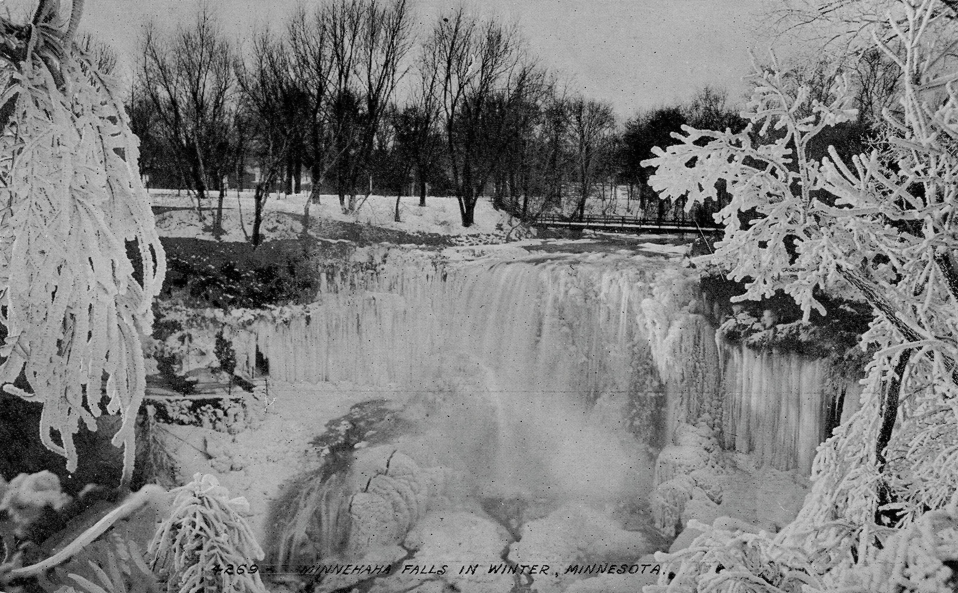
Minnehaha Falls on a postcard around 1910.
I recently received a photo from Edward Tobin Thompson of Maple Grove that I like as well as any.

Minnehaha Falls in January, 1899. (Photo courtesy Edward Tobin Thompson)
The photo, dated January 15, 1899, comes from an old family photo album. Ed doesn’t know who is standing at the foot of the falls, but it is likely the same man pictured on the park bench below, a photo that carries the same date and inscription on the back.

Resting on a bench in Minnehaha Park, January 1899. Judging from the hat, this may be the same man posing in front of the falls. (Photo courtesy Edward Tobin Thompson)
Ed guesses that the man is one of his Tobin ancestors. The Tobins immigrated from Ireland and settled in Wisconsin about 1846, he says. They later lived in the Upper Peninsula of Michigan before moving to Montana.

An imitation Minnehaha Falls? Date and place unknown. (Courtesy Edward Tobin Thompson)
Ed also sent this photo of a waterfall without a label from the same album and he wondered if it could be Minnehaha Falls as well. I don’t think so because in hundreds of pictures I’ve never seen the lip of the falls or the pattern of falling water like this, or the pool of water below the falls so large. Any opinions? Are you watching, Karen Cooper? (Karen has to be the world’s leading authority on images of Minnehaha Falls.) If not Minnehaha Falls, what falls? Any other cataracts in Wisconsin or Minnesota like this? Send in your guesses.
Danger Under the Falls
When photos appeared in the StarTribune recently of people behind the frozen falls, it brought to mind a story from Frank Leslie’s Illustrated Newspaper dated December 25, 1869, which was featured in Minnesota History, the magazine of the Minnesota Historical Society.

An engraving of photographer Charles Zimmerman being knocked unconscious by an icicle, November 28, 1869.
The article described a near tragedy when the falls wasn’t completely frozen. The article was illustrated by the engraving at right. This is how the events involving well-known photographer Charles Zimmerman were originally described in the newspaper:
“Wishing to obtain winter views of a place Longfellow has immortalized in his classic verse, Mr. Zimmerman passed under the falls. An hour later, a Mr. Haines, while exploring the rocks, happened to look behind the curtain of water as it leaped from the edge of the precipice to the abyss beneath and was startled by what he saw. A large icicle weighing between two and three hundred pounds, loosened by the thaw, had severed its connection with the roof above, and had fallen on Mr. Zimmerman, crushing him down, and leaving him insensible beneath it. Mr. Haines quickly relieved the prostrate artist, whom he found nearly frozen. Indeed, had succor been delayed half an hour longer, the unfortunate man would have most certainly died.”
The photographer conked on the head by the giant icicle, Charles Zimmerman, became one of the most prolific shooters of scenes in St. Paul and Minneapolis in the late 1800s. Most of his photographs were sold as stereoviews, the side-by-side photos that took on a 3D appearance when viewed through a stereoscope. If Zimmerman had perished that day under the ice of Minnehaha Falls we would not have nearly so thorough or enjoyable a record of life in Minneapolis in the 19th Century.
Don’t Be Left Insensible
I’d recommend that you not climb up under the falls either. (It is illegal!) Maybe you will do something memorable someday, as Charles Zimmerman did, if you live a little longer.
David C. Smith
© 2015 David C. Smith
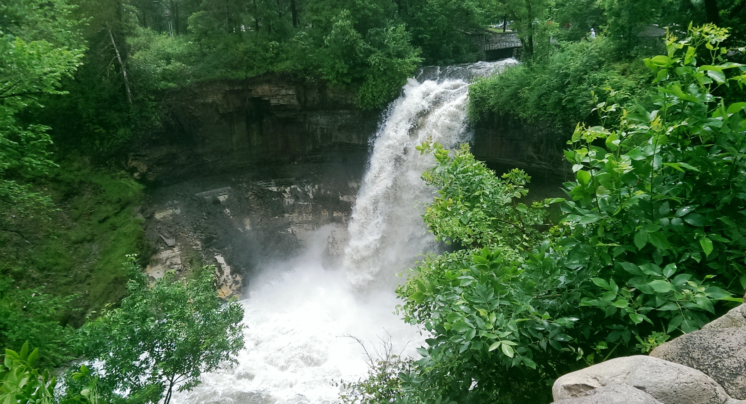
Mississippi River flood
Filed under: Minneapolis parks, Minnehaha Creek, Minnehaha Falls, Mississippi River | Tags: Ford Dam, Minnehaha Falls, Mississippi River
Leave a comment Saturday afternoon I spent a bit more time looking at high water around the city. On that gorgeous afternoon, Minneapolis parks were heavily patronized, partly because of the beautiful day and partly because people were curious about the effects of our summer deluge.
The banks of the Mississippi River that I helped clean in April were under water again. Maybe when these flood waters subside, Friends of the Mississippi River should sponsor another trash pick up. Or we could each take a trash bag along when we go out for riverside hikes.
More evidence of high water on the big creek at the Ford Dam.

High water over the Ford Dam, June 21, 2014. Late last summer, there was no water flowing over the dam and below the dam was mostly dry land. (David C. Smith)

Last summer you could walk from the locks to the island where the submerged trees are now. The Ford Dam is just to the left of this photo. (David C. Smith, June 21, 2014)
Both photos were taken from the bluff at Minnehaha Park and the Soldiers Home. Water levels in Minnehaha Creek had subsided little, if at all, from Thursday to Saturday. Water was still thundering over Minnehaha Falls.
David C. Smith
Minnehaha Falls and Creek: Flood Stage
Filed under: Minneapolis Lakes, Minneapolis parks, Minnehaha Creek, Minnehaha Falls | Tags: Hiawatha Golf Course, Minnehaha Creek, Minnehaha Falls, Minnehaha Parkway
Comments (10) As we await another early evening thunderstorm, I will post a few historic photos of Minnehaha Creek and Minnehaha Falls taken earlier this afternoon. I call them historic because I’ve never seen the creek this high. One man I encountered on my explorations claimed it was a record water level for the creek. I’ll have to look that up.
The entire length of the creek was flooded, of course, even a few hours after the rain had stopped, but these three photos establish landmarks.

The bridge to nowhere. The creek normally flows under the bridge near the top of the photo. Minnehaha Parkway at Humboldt Avenue South, south of the Lynnhurst Recreation Center. (David C. Smith)

Minnehaha Parkway at 16th Avenue South. (David C. Smith)

Looking west on Minnehaha Parkway at Cedar Avenue South. (David C. Smith)
A man I met near Cedar Avenue claimed that the water reached a similar level after a 1988 thunderstorm, but the water subsided very quickly. Today it didn’t. Minnehaha Parkway was barricaded at many points east of Lake Harriet.

More than a water hazard. Hiawatha Golf Course looking south from E. 43rd Street near Standish. That is not Lake Hiawatha in the foreground. (David C. Smith)

A romantic interlude at the famous rapids of Minnehaha Creek! This is only a few yards upstream from the Hiawatha statue. (David C. Smith)
Some early descriptions of the Falls mentioned the heavy mist generated by the falls. That was true today. There was no rain falling while I was taking the pictures below, but I could feel the water in the air. Not quite as dramatic as Victoria Falls, where the cloud of mist over the falls is visible for miles — it’s called Mosi-o-Tunya, the Smoke that Thunders — but still impressive for this normally modest stream in mid-summer.
The falls made famous by Henry Wadsworth Longfellow. I recently discovered startling early plans for the park at the falls that I am waiting for permission to reveal. Stay tuned. (David C. Smith)
Unfortunately such high water levels, like the strong winds of recent years, require expensive cleanup efforts from the park board, stretching already tight park maintenance budgets. Kudos and thanks to the park board crews that will put our water-logged parks in beautiful condition yet again.
David C. Smith
© David C. Smith
Does anyone have any pictures to post of Bassett’s Creek in Theodore Wirth Park or downstream to Bryn Mawr before it dives underground? Is Shingle Creek any better?
Friday Photos: Thousands of Historical Aerial Views
Filed under: Minneapolis Park History Resources | Tags: Borchert Map Library, Minnehaha Auto Tourist Camp, Minnehaha Falls, Minnesota Historical Aerial Photos Online, University of Minnesota Digital Content Library
Comments (8) The closest thing to time travel. That’s what today’s photo recommendation gives you through more than 100,000 photos that allow you to track the growth of Minneapolis — and the rest of the state — from the sky.
I’m not aware of any larger local source of aerial photography than Minnesota Historical Aerial Photos Online (MHAPO). The collection is part of the John Borchert Map Library at the University of Minnesota. It was created by Joseph Koeller in consultation with the Borchert Library staff.
I’ve written before of the Borchert Map Library because I use their maps often, especially their plat maps of Minneapolis from 1892 and 1903, which I have on my “favorites” bar on my computer.
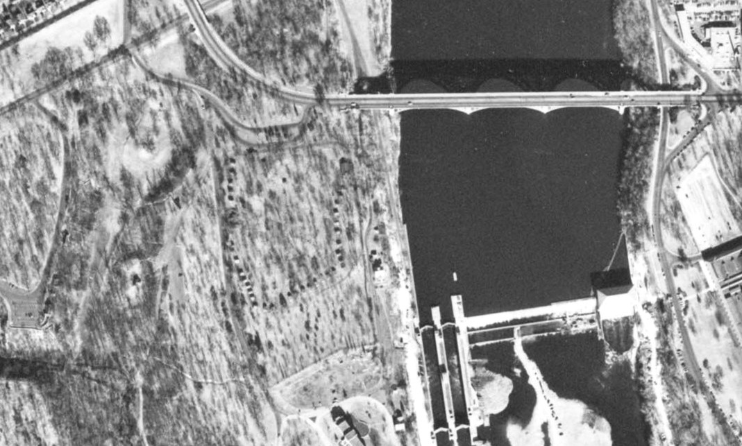
While researching the history of the auto tourist camp, which the park board operated at Minnehaha Falls from 1920s into the mid-1950s, I wanted to get some sense of the layout of the 35 cabins that were offered for rent on a nightly basis. I had never found any depiction of the layout of the camp until I found this photo from October 1953 at the MHAPO site. See the U-shape of dark dots on the bluff to the left of the Ford Dam? Gotta be those cabins. It’s the Wabun picnic area now. I’ll be writing more about the tourist camp soon.
For more recent aerial photos of many parts of Minneapolis and the metropolitan area, I go to the University of Minnesota’s Digital Content Library. Below are two photos from that collection using the search term “Minnehaha Park.” They provide a marvelous way to track changes in the landscape. The only shortcoming of this superb collection of images is that they are not dated.

Long ago you could drive up to the edge of Minnehaha Falls. You could watch the falls from your car. A park drive passed between the falls and the pavilion with the red roof.
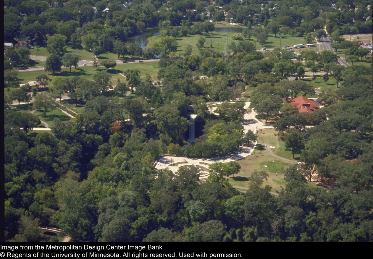
After the 1992 renovation of the park, the parking lot was moved away from Minnehaha Falls and cars could no longer drive right to the edge of the gorge. The former parking lot was replaced by the garden in this picture, which features some verses from Henry Wadsworth Longfellow’s “Song of Hiawatha”, to which the Falls owed its world-wide renown.
Note that both photos were taken before Hiawatha Avenue was expanded and put under a land bridge at Minnehaha Parkway (upper right corner of the photos) in the 1990s. Had the Minnesota highway department had its way, the horizontal stretch of green near the top of the picture would have become an elevated freeway in the 1960s. The Minneapolis park board went all the way to the U. S. Supreme Court in a successful effort to block that freeway. That is an important story of true park heroes, such as Robert Ruhe, Walter Carpenter, Ed Gearty and others, which I hope to tell in greater detail soon.
Some of the photos and maps in the Digital Content Library collection require login to see more than a thumbnail, but many permit viewing in greater detail by the general public.
It’s worth noting that both the Borchert and Digital Content Library collections are the product of our state university—a demonstration that all of us can benefit from the presence of a major university in our community. Our taxes at work! Yeah, I complain about taxes too, but things like parks and libraries and universities and historical societies contribute enormously to the richness of our lives. My life anyway. Nearly all the resources I draw on to produce these articles are public resources. They are available to all without charge. They are an important part of our heritage—and, I hope, our legacy.
David C. Smith
© David C. Smith 2013
The Worst Idea Ever #8: Power Boat Canal from Minnetonka to Harriet
Filed under: Minneapolis Lakes, Minneapolis Parks: General | Tags: 1911 Minneapolis Civic Celebration, Lake Harriet, Lake Hiawatha, Lake Minnetonka, Lake Nokomis, Minnehaha Creek, Minnehaha Falls
Comments (1) Ok, it wasn’t really a Minneapolis park project, but it still deserves a laugh: Minnehaha Creek converted into a 30-foot-wide power boat canal from Lake Minnetonka to Lake Harriet!

Lake Harriet could have been more like Lake Minnetonka.
Minneapolis was obsessed in the spring of 1911 with the upcoming Civic Celebration during which the channel between Lake Calhoun and Lake of the Isles would be opened. That was a very good thing. Huzzah, huzzah. But the attention it was drawing to the city also focused a lot of eyes on a very bad thing: Minnehaha Creek was nearly dry — in the spring! — which meant almost no water over Minnehaha Falls. Minneapolis could hardly celebrate the opening of the lake connection at the same time it suffered the ignominy of a dry Minnehaha Falls. The many out-of-town visitors anticipated for the celebration would surely want to see both. And let’s face it, a fifty-foot waterfall written about by a Harvard poet, which attracted visitors from around the world was a bit more impressive to most people than a short canal under a busy road and railroad tracks. The Minneapolis PR machine could call the city the “Venice of North America” all it wanted with its new canal, but visitors’ imaginations were still probably fueled more by the images of the famous poet’s noble heathen, beautiful maiden, and “laughing waters.”
The generally accepted solution to the lack of water over Minnehaha Falls was to divert Minnehaha Creek into Lake Amelia (Nokomis), drain Rice Lake (Hiawatha), dam the outlet of the creek from Amelia to create a reservoir, and release the impounded water as needed — perhaps 8 hours a day — to keep a pleasing flow over the falls. Unfortunately, with all the last-minute dredging and bridge-building for the Isles-Calhoun channel, that couldn’t be done in 1911 between April and July 4, when the Civic Celebration would launch.
Into this superheated environment of waterways and self-promotion stepped Albert Graber, according to the Saturday Evening Tribune, May 28, 1911. With the backing of “members of the board of county commissioners, capitalists, attorneys and real estate dealers”, Graber proposed to dredge Minnehaha Creek into a canal 30-feet wide from Lake Minnetonka to Lake Harriet. This would provide not only a water superhighway from Minnetonka to Minneapolis, and boost real estate prices along the creek, but it would also create a much larger water flow in Minnehaha Creek, solving the embarrassment of no laughing water.
“The plan, say the promoters, would enable residents of summer houses on the big lake to have their launches waiting at the town lake.”
Saturday Evening Tribune, May 28, 1911
Sure, there were problems. Not every plan could be perfect. The plan would require dismantling the dam at Gray’s Bay at the head of Minnehaha Creek, which might lower the level of Lake Minnetonka. But Graber and his backers had thought of that. The Minnesota River watershed in the area of St. Bonifacius and Waconia would be diverted into Lake Minnetonka — no problem! — which also solved another bother: it would reduce flooding on the Minnesota River.
The dam at Gray’s Bay had been operated by Hennepin Country since 1897. Many people then and now consider the dam the cause of low water flow in Minnehaha Creek, but the earliest reference I can find to low water in the creek was in 1820, when the soldiers of Fort Snelling wanted to open a mill on Minnehaha Creek, but were forced to move to St. Anthony Falls due to low water. That was even before two intrepid teenagers from the fort discovered that the creek flowed out of a pretty big lake to the west.
Graber estimated that dredging Minnehaha Creek would cost about $4,000 a mile for the nine miles between the two lakes. He and his backers, which included an officer of the Savings Bank of Minneapolis (who presumably had a summer house on the big lake and could put a launch on the town lake), provided assurances that the money to finance the project could be “readily found.”
The Evening Tribune article concluded with an announcement that meetings of those interested in the project would be held in the near future with an eye to beginning work before the end of the summer. Graber noted that his inspection of the project had been, no surprise, “superficial”, but that he would make a thorough report soon to his backers. I can find no evidence that the idea progressed any further.
The Board of Park Commissioners would have had no role in the plan, except, perhaps, allowing power boats to enter and be anchored on Lake Harriet. (I think they would have said no.) Park board ownership of Minnehaha Creek west of Lake Harriet to Edina wasn’t proposed until 1919 and the deal wasn’t done until 1930.
David C. Smith
© 2013 David C. Smith

