Archive for the ‘Brownie Lake’ Tag
1955 Was a Very Dry Year
Filed under: Minneapolis parks | Tags: Bassett's Creek, Brownie Lake, Fairchild Aerial Surveys, Lake Calhoun, Lake of the Isles, Minnehaha Creek, Mississippi River, St.Anthony Falls
 Comments (9)
 It’s not a common sight. I’d never seen it myself until I saw this picture from Fairchild Aerial Surveys taken in 1955. St. Anthony Falls is completely dry.

The concrete apron at St. Anthony Falls is bone dry in 1955. The 3rd Avenue Bridge crosses the photo. Dry land — even a small structure — left (west) of the falls stand where the entrance to the lock is now. (Fairchild Aerial Surveys, Minneapolis Park and Recreation Board)
Water levels were down everywhere at the time. Meteorological charts list 1955 as the 13th driest year on record in Minneapolis, but a look at longer-term data reveal that rainfall had been below normal for most of the previous 40 years. Downstream from St. Anthony Falls, the river was also very low, revealing the former structure of the locks at the Meeker Island Dam.

The old lock structure from the Meeker Island Dam protrudes from the low water in 1955. The old lock and dam between Franklin Avenue and Lake Street were destroyed when the new “high dam” or Ford dam was built near the mouth of Minnehaha Creek downriver. (Fairchild Aerial Surveys, Minneapolis Park and Recreation Board)
That dry spell had a significant impact on park property. Many park board facilities, from beach houses to boat houses and docks, were permanent structures that required proximity to the water’s edge. Parks were also landscaped and mowed to the water line and, since the depression, at least, many lakes had WPA-built shore walls that looked goofy a few feet up on dry land.
Park board annual reports provide time-lapse updates.
1948: Minnehaha Creek dry most of the year, lakes down 1.5 feet.
1949: Chain of Lakes 2 feet below normal, rainfall 2.5 inches below normal, water in Minnehaha for limited time during year
1950: Lake levels at record lows, lake channels dredged 4.5 feet deeper to allow continued use, water in Minnehaha Creek for only brief period in spring
1951: Record snowfall and heavy rains raised lake levels 0.44 feet above normal in April; flooding problems along Minnehaha Creek golf courses required dikes to make courses playable; attendance at Minnehaha Park high all year due to impressive water flow over falls.
1952: Wet early in year, dry late; lake levels stable except those that depend on groundwater runoff, such as Loring Pond and Powderhorn Lake, which were down considerably at end of year
1953: Lake levels fluctuated 1.5 feet from early summer to very dry fall; flow in Minnehaha Creek stopped in November; U.S. Geological Survey began testing water flow in Bassett’s Creek for possible diversion
1954: Again, water level fluctuations; near normal in early summer, low in fall; Minnehaha Creek again dry in November.
1955: Fall Chain of Lakes elevation lowest since 1932, but Lake Harriet near historical normal; Minnehaha dry most of year
1956: Lakes 4 feet below normal, weed control required, boat rentals incurred $10,000 loss
1957: City water — purchased at a discount! — pumped into lakes raised lake levels 1.5 feet; park board began construction of $210,000 pipeline from Bassett’s Creek, which, unlike Minnehaha Creek, had never been completely dry, to Brownie Lake.
1958: Second driest year on record; Minnehaha Creek dry second half of year; pumps activated on pipeline from Bassett’s Creek, raised water level in lakes 4.2 inches by pumping 84,000,000 gallons of water.
1959: Dry weather continued; Park board suggested reduction in water table may be result of development; Park board won a lawsuit against Minikahda Club for pumping water from Lake Calhoun to water golf course. When Minikahda donated lake shore to park board for West Calhoun Parkway in 1908 it retained water rights, but a judge ruled the club couldn’t exercise those rights unless lake level was at a certain height — higher than the lake was at that time — except in emergencies when it could water the greens only. Lakes were treated with sodium arsenite to prevent weed growth in shallower water; low water permitted park crews to clean exposed shorelines of debris.
1960: Lake levels up 4 feet due to pumping and rain fall; channels between lakes opened for first time in two years; hydrologist Adolph Meyer hired to devise a permanent solution to low water levels.

To celebrate the rise in water levels sufficient to make the channels between the lakes navigable after being closed for a couple of years, park superintendent Howard Moore helped launch a canoe in the channel between Lake of the Isles (in background) and Lake Calhoun in 1960. He seems not to mind that one foot is in the drink. (Minneapolis Park and Recreation Board)
That’s more than a decade’s worth of weather reports. The recommendation of hydrologist Adolph Meyer was very creative: collect and recycle water from the air-conditioners in downtown office buildings and stores, and pump it to the lakes. That seemed like a good idea until the people who ran all those air-conditioners downtown thought about it and realized they could recycle all that water themselves through their own air-conditioners and save a lot of money on water bills. End of good idea. Instead the park board extended its Chain of Lakes pumping pipeline from Bassett’s Creek all the way to the Mississippi River. But that’s a story for another time.
If you’ve followed the extensive shoreline construction at Lake of the Isles over the last many years, you know that water levels in city lakes remains an important, and costly, issue—and it probably always will be. It’s the price we pay for our city’s water-based beauty.
David C. Smith
Afterthought: The lowest I ever remember seeing the river was following the collapse of the I-35W bridge. The river was lowered above the Ford Dam to facilitate recovery of wreckage from that tragedy. Following a suggestion from Friends of the Mississippi River, my Dad and I took a few heavy-duty trash bags down to the river bank near the site of the Meeker Island Dam to pick up trash exposed by the lower water levels. Even then the water level wasn’t as low as in the Fairchild photos.
Brownie Lake Long Ago
Filed under: Minneapolis Lakes, Minneapolis parks | Tags: Brownie Lake, Charles J. Hibbard, Theodore Wirth Park
Comments (2) As we look forward to improvements at Brownie Lake later this year and in 2013 I find it informative to look at photos of the area long ago. Of course the construction of the Prudential Building (now housing Target offices) next to the lake in 1954 changed the lake environs considerably. (See a photo of the building under construction here.) But the lake is also hemmed in by a freeway that keeps expanding on the north and a railroad/trail corridor that keeps shrinking on the south.

An undated photo labelled “Brownie Lake with Cedar Lake in the distance.” (C. J. Hibbard & Co., MPRB)
This photo puzzles me, however. If it is Brownie Lake what is the trestle on the near side of the lake in the photo? I’ve never seen that before. Can anyone enlighten me?

Charles J. Hibbard, 1916 (Minnesota Historical Society)
The back of the photo bears the stamp of C. J. Hibbard & Co. Charles Hibbard was an active photographer in Minnesota from about 1899 until his death in 1924. Those dates establish the range of years in which the Brownie Lake picture above could have been taken.
Hibbard wasn’t directly associated with parks, although many of his photos were taken in parks, but he deserves an entry of his own here some day. Based on the photos I’ve seen he was the preeminent photographer of the city. He chronicled many places and events in Minneapolis and the state. The detail and composition of his photos are remarkable.
Both of the photos below were taken at the intersection of Theodore Wirth Parkway and Highway 12 (I-394). In the first photo, a bridge is being built to carry Wirth Parkway traffic over the new four-lane highway. This photo shows the early stages of the construction of a wider highway. Notice how narrow Highway 12 was. Trees and telephone poles hug the edge of the road.

Highway 12 and Glenwood (Wirth) Parkway, 1949 (MPRB)
The second photo, also labelled as being shot in 1949, shows the progression in road building. Today’s I-394 is, of course, much wider than the four lane highway shown here. The wetland at the north end of Brownie Lake has also been filled in.

Highway 12 expands and eats into Wirth Park, 1949 (Minneapolis Star Journal, Minnesota Historical Society)
Expansion of Highway 12 into I-394 eventually took more of the parks. On the other side of the ledger, however, the wide swath of railroads in the upper third of the photo have been converted partly into bicycle trails.
David C. Smith
Lost Minneapolis Parks: The Complete List, Part I
Filed under: Lost Minneapolis Parks, Minneapolis Parks: General | Tags: Brownie Lake, Elwell Field, The Gateway, Theodore Wirth Park
Comments (3) I’ve written about several parks in Minneapolis that are no more. Since then I’ve been asked if there is a list of those “lost” parks. The short answer is, “Not until now.” Here’s the first part of an alphabetical list I’ve compiled from park board proceedings and annual reports.
19th Avenue South and South 1st Street. 1.0 acre. The park board’s 1948 annual report noted that the site near Seven Corners had been graded and frames had been installed for swings, teeter-totters and slides for small children. The plan was to complete the playground in 1949. This parcel was leased specifically for use as a playground. I don’t know the terms of the lease, but it was still included in park inventory as leased land in the 1964 annual report. The U of M’s West Bank softball fields are now near the site. 19th Avenue South at that point is the approach to the 10th Avenue Bridge over the Mississippi River.
Bassett Triangle. 7th Avenue North and 7th Street North, 0.03 acre. Acquired from the city council December 3, 1924. Returned to the city council in 1968, after the board hired appraisers in 1967 to try to sell the property. The site is now occupied by a Wells Fargo Bank. The property was named for Joel Bean Bassett, who owned much of the land in the vicinity in the 1800s. Bassett’s Creek, underground not far away, is also named for him.
Bedford Triangle. Orlin Avenue SE and Bedford Avenue SE, 0.01 acre. This little triangle in Prospect Park was still carried on the park board’s inventory the last time I checked, but it was listed as “paved.” There is no visual evidence of the triangle. Read more about this and other triangles in the meandering streets below Tower Hill.
Brownie Lake (partial). Theodore Wirth Park west of Brownie Lake and south of Highway 12, 32 acres. The land was sold in 1952 to the Prudential Insurance Company for $200,000 and some additional land.

The southern end of Theodore Wirth Park west of Brownie Lake got a makeover when the Prudential Insurance Company purchased the land for its regional headquarters in 1952. It was the largest section of park land the Minneapolis park board has ever sold. Construction is underway in this 1954 photo. (Minneapolis Star Journal Tribune, Minnesota Historical Society)
The park board bowed to intense public pressure to sell the land beside the lake. Prudential had made it clear that the site adjacent to the lake was the only site it would consider for its offices in the city. Ultimately the park board was convinced that the benefit to the Minneapolis economy was a greater good than keeping the land as a park. The board justified its action in part by asserting that with the growth of traffic on Highway 12 (now I-394) and the widening of that road, the land west of Brownie Lake had already been isolated from the rest of Wirth Park anyway.
Cedar Avenue Triangle. Cedar Avenue and 7th Street South, 0.02 acre. The triangle was offered to the park board by Edmund Eichorn on April 15, 1891. After delaying a decision for a couple of months, the board agreed to pay Eichhorn $2,394 over ten years without interest. The triangle, adjacent to what is now the Cedar Avenue exit ramp from I-94 westbound, was sold to the state highway department in 1965 for $1,000. In April of that year the board approved a resolution to sell the property for $1,000 plus “other valuable considerations.” Later that year the board approved dropping the “other valuable considerations” clause.
Crystal Lake Triangle. West Broadway and 30th Avenue North, 0.05 acre. The triangle was supposedly purchased July 21, 1910 and sold to the state in 1962 for $2,700. It once sat at the edge of what is now the hideous intersection of Theodore Wirth Parkway, West Broadway (County Highway 81) and Lowry Avenue. Imagine if Phelps Wyman’s 1921 plan for that complex intersection had been used. What a difference it would have made in that part of Minneapolis. It would’ve been gorgeous.
Dell Place. Dell Place between Summit and Groveland avenues, 0.04 acre. Transferred from the city council April 27, 1883 when the park board was created. Citizens near the tiny lot petitioned the park board in 1907 to plant and maintain the grounds, which the park board agreed to do — if residents of the area would first pay to have the parcel curbed and filled to street grade. The street triangle was sold to the Minnesota highway department for I-94 interchanges in 1964 for $1,350. The park board had rejected the state’s first offer of $450. The park board’s appraisers valued the land at $2,250, but the park board accepted an internmediate figure instead of proceding to court with litigation.
Elwell Field I. East Hennepin and 5th Avenue SE, 3.7 acres. Purchased in 1939 from the Minneapolis Furniture Company for $5,000. Sold to Butler Manufacturing in 1952 for $55,000. The somewhat isolated field, surrounded by industrial buildings, was sold with the promise to the neighborhood to acquire another playground nearer Holmes School. Eventually the land adjacent to the school was purchased as a playground. The school on the former Holmes site, built in 1992, is now named Marcy Open School.

The first Elwell Field, 1952. Across the field is a building of the Butler Manufacturing company, which purchased the field the year the picture was taken. (Norton and Peel, Minnesota Historical Society)
Elwell Field II. 9th Avenue SE between SE 4th Street and SE 5th Street, 1 acre. The former site of Trudeau School was acquired February 4, 1953 in a trade with the school board. The park board gave up Sheridan Field next to Sheridan School at Broadway and University Avenue NE for the Trudeau property. The second Elwell Field was condemned by the state highway department for I-35W in 1962. The park board accepted a negotiated payment of $125,000 for the park in 1966.
Franklin Triangle. Franklin Terrace and 30th Avenue South, 0.05 acre. Transferred to the park board from the city council August 13, 1915 and accepted and named by the park board September 6, 1916. Taken by the state highway department for I-94 in 1962 in exchange for $1 and “other valuable considerations” again.

The beautiful cover of the park board’s 1915 annual report depicted the fountain at The Gateway. (Minneapolis Park and Recreation Board)
The Gateway. Hennepin and Nicollet avenues, 1.22 acres. There is still a Gateway park property at Hennepin and 1st Street South, but it’s not in the same location, so I consider this original Gateway a lost park. I have already provided the outline of the story for the original Gateway on the history pages of the Minneapolis Park and Recreation Board’s website at minneapolisparks.org.
Groveland Triangle. Groveland and Forest avenues, 0.21 acre. The triangle was purchased in November 1910 for $8,979. It was sold to the state highway department for the construction of I-94 in 1964 for $8,900.
That’s all for Part I of Lost Minneapolis Parks. Part II — H-R — will be out soon.
Historical profiles of all existing Minneapolis parks can be found at the website of the Minneapolis park board. Each park has its own page with a “History” tab.
If you remember anything about any of the lost parks mentioned here, please send me a note so we can preserve something of those parks — especially the property beside Brownie Lake. Any memories before Prudential moved in?
David C. Smith
© David C. Smith
The “Brownie” in Brownie Lake
Filed under: Minneapolis parks | Tags: Agnes "Brownie" McNair Hull, Brownie Lake, Cedar Lake Parkway, Charles M. Loring, Minneapolis parks, William McNair, Wilson Park
Comments (2) In the historical profile I wrote about Brownie Lake for the Minneapolis Park and Recreation Board, I reported that I had found a handwritten note on an old park board document that attributed the lake’s name to the nickname of William McNair’s daughter. Now, I’ve also found a newspaper reference to that.
The Minneapolis Tribune of November 13, 1910 reported on the origin of the names of Minneapolis lakes. The article said Brownie Lake was taken from the nickname of Mrs. Louis K. Hull. Louis Hull, a prominent young attorney in Minneapolis, married Agnes McNair, one of two daughters of William McNair, on December 12, 1892.
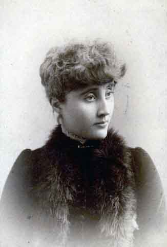
William McNair was an influential attorney and businessman in Minneapolis who had died in 1885. Among his many real estate holdings in the city was a 1,000-acre farm that stretched across much of near north Minneapolis to include Brownie Lake. At the time of his death he was said to be in negotiation with the park board to donate a 100-foot-wide strip of land for a parkway that would have extended from Lake of the Isles, around Cedar Lake, to Farview Park in north Minneapolis. It was said he already owned nearly all the land that would be required for that four-mile parkway. His obituary (September 16, 1885, Minneapolis Tribune) claimed that he was building a mansion at 13th and Linden (facing Hawthorne Park) that would rival W. D. Washburn’s “Fair Oaks” in south Minneapolis. Louise McNair, his widow, apparently finished it, judging by this photo. Whatever happened to it? Did it outlive Fair Oaks?

A curiosity about Brownie Lake: about half of the lake was platted into streets and “blocks.” The map of Cedar Lake and environs in the 1909 annual report of the park board shows Drew, Chowen and Beard avenues platted through Brownie Lake. Much of the land for Cedar Lake Parkway, and park board control of Cedar Lake, came from donations by McNair’s widow, Louise. She was the sister of McNair’s first law partner, Eugene Wilson, who was an important park commissioner and the attorney for the first park board. Hawthorne Park, where the McNair’s were building their mansion, was later renamed Wilson Park after Eugene Wilson. Wilson Park was condemned in the 1960s to become part of the I-94 interchange.

The park and playground west of Cedar Lake, which has always been known as Reserve Block 40, but never formally named, is in a neighborhood known as McNair Park. As residents of the Bryn Mawr neighborhood consider renaming Reserve Block 40, they could do worse than to keep the McNair Park name.
A final bit of Brownie Lake-related trivia: One of the pall bearers at William McNair’s funeral was Charles M. Loring. What makes that noteworthy in these days of political and philosophical rancor is that Loring and McNair were local leaders among Republicans and Democrats respectively. Clearly they were able to see past their political differences.
David C. Smith
© David C. Smith

