Archive for the ‘Folwell Park’ Tag
The Street with the Most Parks?
Filed under: Minneapolis parks | Tags: Alexander von Humboldt, Bethune Park, Creekview Park, Folwell Park, Humboldt Triangle, Lynnhurst Park
 Comments (2)
 Last week the park board sent out notifications of the official opening of new facilities at two parks. First, on Wednesday there was a ribbon cutting at the new skate park at Folwell Park in north Minneapolis. Then on Friday, the ribbon was cut for a new playground at Lynnhurst Park in south Minneapolis. The ceremonies were attended by the park commissioner for each district, Charles Rucker at Folwell and Cathy Abene at Lynnhurst.
Google Maps tells me the parks are about 7.6 miles apart as the crow flies — and that crow would be flying almost exactly due north or south, because the two parks are both on Humboldt Avenue. Or its equivalent. Humboldt Avenue South on the east side of Lynnhurst Park is now called West Minnehaha Parkway which connects Lake Harriet to Minnehaha Creek south of 50th Street and the Lynnhurst Recreation Center.
Coincidentally, I visited Folwell Park the Sunday before the ribbon cutting. It is one of the most underappreciated and on that perfect Sunday afternoon one of the most underused parks in the city. I visited the park precisely because of its location on Humboldt Avenue. I had recently read a fascinating biography of Alexander von Humboldt, the man for whom the avenue was named. The book is a powerful reminder of the interconnectedness of everything on the planet.
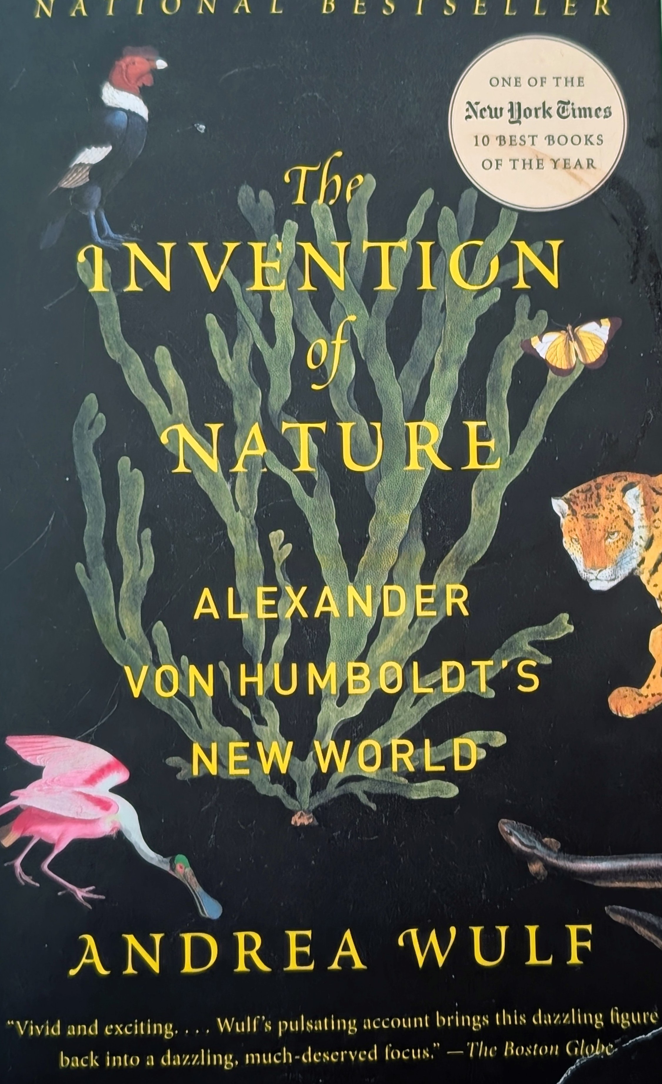
Humboldt was a German scientist known and revered around the world (when nearly all people still believed in science!) in the early 1800s. St. Paul’s Humboldt High School is also named for him as are many places, natural features around the globe, and many species of flora and fauna — as well as an asteroid, a mineral, and a geographical feature of the moon.
Folwell and Lynnhurst are not the only parks that sit along Humboldt Avenue. The avenue also runs on the west side of Bethune Park and on the east side of Shingle Creek and Creek View Park.
There’s also the modest Humboldt Triangle on Humboldt Avenue North which played a role in the impending fight between the park board and the Minnesota highway department over the taking of park land for highways. You can read about that in my history of the triangle on the Park Board’s website. (Yikes! Note my error in calling von Humboldt by the wrong first name there; he was Alexander, not Friedrich.)
The improvements to Folwell and Lynnhurst were both part of the Minneapolis Park and Recreation Board’s 20-year Neighborhood Park Plan in partnership with the City of Minneapolis. A Youth Activities Grant from Hennepin County also contributed to the skate park at Folwell.
David Carpentier Smith
100 Years Ago: Altered Electoral Map and Shorelines
Filed under: Grand Rounds, Minneapolis Golf Courses, Minneapolis Park Board, Minneapolis Parks: General, Mississippi River | Tags: Dr. Martin Luther King Park, Folwell Park, Lake Calhoun, Lake Nokomis, Phelps Park, St. Anthony Boulevard, Theodore Wirth
Comments (10) What has changed in 100 years? A few times on this site, I have looked back 100 years at park history. I’ll expand my scope this year because of extraordinary political developments. Politics first, then parks.
The national electoral map flipped. The electoral map of the 1916 Presidential contest is astonishing. Woodrow Wilson, a Democrat, won a close re-election against Republican candidate Charles Hughes, a Supreme Court Justice. Compare red and blue states below to today. Nearly inverted. The Northeast, Upper Midwest and Far West — well, Oregon — voted alike. Republican. And lost.

The 1916 electoral map was nearly opposite of the 2016 electoral map in terms of party preference. Unlike 2016, President Wilson won both the popular vote and the electoral vote, but his electoral-vote margin was smaller than Donald Trump’s. If the total of votes cast in 1916, fewer than 19 million, seems impossibly low even for the population at that time, keep in mind that only men could vote. (Source: Wikipedia)
While Minnesota’s electoral votes were cast for the Republican — although Hughes received only 392 more votes than Wilson out of nearly 400,000 cast — Minneapolis elected Thomas Van Lear as its mayor, the only Socialist to hold that office in city history. One hundred years later, Minneapolis politics are again dominated by left-of-center politicians.
The population of Minneapolis in 1916 and 2016 was about the same: now a little over 400,000, then a little under. Minneapolis population peaked in mid-500,000s in mid-1950s and dropped into mid-300,000s in late 20th Century. One hundred years ago, however, Minneapolis suburbs were very sparsely populated.
The world 100 years ago was a violent and unstable place. World War I was in its bloody, muddy depths, although the U.S. had not yet entered the war, and Russia was on the verge of revolution. Now people are killed indiscriminately by trucks, guns, and bombs. People worldwide debated then how to address the excesses of capitalists, oligarchs and despots unencumbered by morality. We still do.
One notable change? Many Americans campaigned in 1916 to put women in voting booths, in 2016 to put a woman in the Oval Office.
Continuing Park Growth: North and South
How about progress in parks? The Minneapolis park board added significantly to its playground holdings in 1916 and 1917 as public demand for facilities and fields for active recreation increased. In North Minneapolis, Glenwood (Theodore Wirth) Park was expanded and land for Folwell Park was acquired. In South Minneapolis, Nicollet (Rev. Dr. Martin Luther King, Jr.) Park and Chicago Avenue (Phelps) Park were purchased and land for Cedar Avenue Park was donated. In 1917, the first Longfellow Field was sold to Minneapolis Steel and steps were initiated to replace it at its present location.
One particular recreational activity was in park headlines in 1916 for the very first time. A nine-hole course was opened that year at Glenwood (Theodore Wirth) Park, the first public golf course in Minneapolis. Golf was free and greens weren’t green, they were made of sand. In less than ten years, the park board operated four 18-hole courses (Glenwood [Wirth], Columbia, Armour [Gross], and Meadowbrook) and was preparing to add a fifth at Lake Hiawatha.
The Grand Rounds were nearly completed conceptually, when first plans for St. Anthony Boulevard from Camden Bridge on the Mississippi River to the Ramsey County line on East Hennepin Avenue were presented in 1916. Park Superintendent Theodore Wirth also suggested that the banks of the Mississippi River above St. Anthony Falls might be made more attractive with shore parks and plantings, even if the railroads maintained ownership of the land. One hundred years later we’re still working on that, but have made some progress including the continuing purchase by the Park Board of riverfront lots as they have become available.These have been the only notable additions to park acreage in many years.
One important result of the increasing demand for playground space in Minneapolis one hundred years ago was the passage by the Minnesota legislature in 1917 of a bill that enabled the park board to increase property tax collections by 50%. In 2016, the Park Board and the City Council reached an important agreement on funding to maintain and improve neighborhood parks.
Altered Shorelines
In a city blessed with water and public waterfronts, however, some of the most significant issues facing the Minneapolis park board in 1917 involved shorelines — beyond beautifying polluted river banks.
The most contentious issue was an extension of Lake Calhoun, a South Bay, south on Xerxes Avenue to 43rd Street. Residents of southwest Minneapolis wanted that marshy area either filled or dredged — dry land or lake. There was no parkway at that time around the west and south shore of Lake Calhoun from Lake Street and Dean Parkway to William Berry Parkway. As a part of plans to construct a parkway along that shoreline, the park board in 1916 approved extending Lake Calhoun and putting a drive around a new South Bay as well.
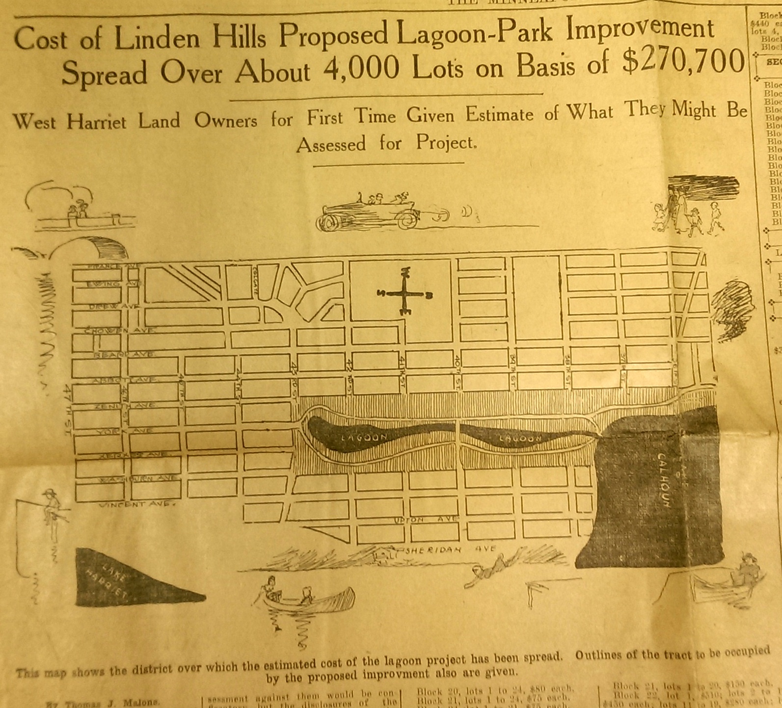
This drawing from a 1915 newspaper article shows the initial concept of a South Bay and outlines how it would be paid for. (Source: Minneapolis Sunday Tribune, June 20, 1915)
The challenge, of course was how to pay for it. The park board’s plan to assess property owners in the area for the expensive improvements was met with furiuos opposition and lawsuits. Many property owners thought that assessments they were already paying for acquisitions and improvements over the years at Lake Calhoun, Lake Harriet and William Berry Park were too heavy. The courts eventually decided in favor of the park board’s right to assess for those improvements, but by then estimated costs for the project had increased and become prohibitive and the South Bay scheme was abandoned.
Instead land for Linden Hills Park was acquired in 1919 and the surrounding wet land was drained into Lake Calhoun in the early 1920s. Dredged material from the lake was used to create a better-defined shoreline on the southwestern and northwestern shores of the lake in 1923 in preparation for the construction of the parkway.
Flowage Rights on the Mississippi River and a Canal to Brownie Lake
Minneapolis parks also lost land to water in 1916. The federal government claimed 27.6 acres of land in the Mississippi River gorge for flowage rights for the reservoir that would be created by a new dam to be built near Minnehaha Creek. Those acres, on the banks of the river and several islands in the river, would be submerged behind what became Lock and Dam No. 1 or the Ford Dam. In exchange for the land to be flooded, the park board did acquire some additional land on the bluffs overlooking the dam.
The other alteration in water courses was the dredging of a navigable channel between Cedar Lake and Brownie Lake, which completed the “linking of the lakes” that was begun with the connection of Lake of the Isles and Lake Calhoun in 1911. The land lost to the channel was negligible and probably balanced by a slight drop in water level in Brownie Lake. (A five-foot drop in Cedar Lake was caused by the opening of the Kenilworth Lagoon to Lake of the Isles in 1913.)
Another potential loss of water from Minneapolis parks may have occurred in 1917. William Washburn’s Fair Oaks estate at one time had a pond. I don’t know when that pond was filled. The estate became park board property upon the death of Mrs. Washburn in 1915. Perhaps in 1917 when the stables and greenhouses on the southwest corner of the property were demolished, the south end of the estate was graded and the pond was filled. Theodore Wirth’s suggestion for the park, presented in 1917, included an amphitheater in part of the park where the pond had once been.
The Dredge Report
The year 1917 marked the end of the most ambitious dredging project in Minneapolis parks — in fact the biggest single project ever undertaken by the park board until then, according to Theodore Wirth. The four-year project moved more than 2.5 million cubic yards of earth and reduced the lake from 300 shallow acres to 200 acres with a uniform depth of 15 feet.
That wasn’t the end of work at Lake Nokomis, however. The park surrounding the lake, especially the playing fields northwest of the lake couldn’t be graded for another five years, after the dredge fill had settled.
Dredging may again be an issue in 2017 if the Park Board succeeds in raising funds for a new park on the river in northeast Minneapolis. Dredges would carve a new island out of land where an old man-made island once existed next to the Plymouth Avenue Bridge. But that may be a long time off — and could go the way of South Bay.
Park Buzz
One other development in 1917 had more to do with standing water than was probably understood at the time. The Park Board joined with the Real Estate Board in a war on mosquitoes. However, after spending $100 on the project and realizing they would have to spend considerably more to achieve results, park commissioners terminated the project. It was not the first or last battle won by mosquitoes in Minneapolis.
As we look again at new calendars, it’s always worth taking a glance backward to see how we got here. For me, it is much easier to follow the course of events in Minneapolis park history than in American political history.
David C. Smith
Comments: I am not interested in comments of a partisan political nature here, so save those for your favorite political sites.
Minnehaha Park Fireplace Mystery Solved
Filed under: Minneapolis parks, Minnehaha Falls | Tags: Folwell Park, Keewaydin Park, Marv Nelson, McRae Park, Minneapolis Veterans Hospital, Minnehaha Dog Park, Minnehaha Park
Comments (3) The mystery of the fireplace in the dog park at Minnehaha Park has been solved thanks to reader “Tom.” Many people have followed this issue or expressed an interest in it and I know that many readers don’t check back to see comments on posts, so I wanted to bring this comment to your attention.

The fireplace surrounded by picnic tables in 1935. (Minnesota Historical Society)
This is the photo of the fireplace that Tom found in the collection of the Minnesota Historical Society, which includes more than 230,000 photographs. As I’ve noted many times, that collection is invaluable and immensely enjoyable. The picnic ground belonged to the Minneapolis Veterans Hospital according to the photo description. Tom further notes that the park board acquired this land in 1959. Thanks for your comment, Tom. Does anyone want to tell us when the fireplace and picnic ground were built?
Excellent Comments
I would suggest that you check back on your favorite park subjects occasionally to see recent comments, or subscribe to comments on any post. Especially interesting in recent months have been
Chuck Solomon’s comment in which he named all of the coaches and nearly every player from a McRae Park football photo
Another tribute to Marv Nelson, a youth football coach at Folwell Park in the 1960s and 1970s
Memories of Keewaydin Park, especially kids’ games and hockey.
These are just a few of the comments in recent months. Thanks to everyone who has commented on the articles here or has contacted me personally with more stories. I appreciate them all. Stories: that’s what this web site is all about.
David C. Smith
© 2014 David C. Smith
Minneapolis Park Memory: More Folwell Football
Filed under: Minneapolis Park Memory | Tags: Bob Shogren, Folwell Park, Football, Jim Krave
Leave a comment In September of ’63 dad dropped off Mike Boe and myself at Folwell for Pee Wee football. We were coached by Bob Shogren a corpulent but athletic looking guy who showed up at our practices in a big yellow cab. Word was that Bob had signed with the Cowboys, but had a knee problem that ended his career. Bob seemed to know what he was doing, and taught us about ‘dives’, ‘cross-bucks’, ‘sweeps’, and ‘reverses.’ We learned the idiosyncrasies of the ‘safety’ and the ‘on-side’ kick.
Saturday morning, 45 minutes before kickoff we would assemble in the Folwell pavilion, a strange salmon-colored stucco structure built into a hillside in the middle of the park for the weigh in. Pee Wees could weigh no more than 100 lbs without equipment. A couple of the guys, had a heck of a time making weight.
We then slipped into our gear, a helmet, jersey, and shoulder pads. Football pants were optional, and if they did appear they were the tan canvas ones right out of Norman Rockwell.
This left the game, which consisted of 4 seven-minute quarters, played on a hard pan field marked with powdered lime or pea gravel. We played with a yellow Penn Rubber Co. black striped football, which I never saw any where else.
Two high school-age refs and a volunteer chain gain kept things in order as the assembled parents on the sideline cheered us on and we all enjoyed what at that age was a simple and nonviolent game.
Jim Krave
Thanks for the memory, Jim.
Minneapolis Park Memory: Coach Marv Nelson
Filed under: Minneapolis Park Memory, Minneapolis Parks: General | Tags: Folwell Park, Football, Marv Nelson
Comments (13) I was at a Patrick Henry Foundation ‘doings’ a couple of weeks ago and Marv Nelson’s name came up. Marv was a milk driver for Ewalds or Clover Leaf, but his passion was sports. He coached baseball, football, and hockey and the Cootie VFW was the sponsor, so his teams were the ‘Antsinpants’, but also called Marv’s Boys. It’s not like there was just one team. There were peewees, cubs, and midgets and Marv would have players on the midget teams coach the cubs and the peewees. Marv followed the Henry thing, so everything was red and gray. He always wore a sweat shirt, khakis (work pants, not dockers) and a red ball cap. He had glasses, a snarl and a cauliflower ear. He was ancient in 1965 and coached several more years. He was at Folwell, Bohanan, Shingle Creek. Any given spring there were at least 100 kids on Marv’s Boys teams. The northside never saw anyone like him.
The VFW also sponsored a “Cootie Bum Band” which would march in parades far and wide all through the 70s.
Jim Krave
Inspiration, Ideas and Ideals (Courtesy of William Watts Folwell)
Filed under: Minneapolis Parks: General | Tags: Folwell Park, Minneapolis parks, William Watts Folwell
Comments (1) Park history provides more than pretty pictures. Thanks to people such as William Folwell, it also gives us inspiring words. Such inspiration has perhaps never been needed more than now when political discourse is dominated by petty self-interest and shallow swagger.
“We owe it to our children and to all future dwellers in Minneapolis to plan on a great and generous scale. If we fail to accomplish, let them know it was not for lack of ideas or ideals.”
— William W. Folwell, President, Minneapolis Board of Park Commissioners, Eighteenth Annual Report, 1900

William W. Folwell attended the dedication of facilities at Folwell Park, July 4, 1925. He was 92. (Minnesota Historical Society, por 12574 r18)
David C. Smith

