Archive for the ‘Minneapolis Golf Courses’ Category
100 Years Ago: Altered Electoral Map and Shorelines
Filed under: Grand Rounds, Minneapolis Golf Courses, Minneapolis Park Board, Minneapolis Parks: General, Mississippi River | Tags: Dr. Martin Luther King Park, Folwell Park, Lake Calhoun, Lake Nokomis, Phelps Park, St. Anthony Boulevard, Theodore Wirth
 Comments (10)
 What has changed in 100 years? A few times on this site, I have looked back 100 years at park history. I’ll expand my scope this year because of extraordinary political developments. Politics first, then parks.
The national electoral map flipped. The electoral map of the 1916 Presidential contest is astonishing. Woodrow Wilson, a Democrat, won a close re-election against Republican candidate Charles Hughes, a Supreme Court Justice. Compare red and blue states below to today. Nearly inverted. The Northeast, Upper Midwest and Far West — well, Oregon — voted alike. Republican. And lost.

The 1916 electoral map was nearly opposite of the 2016 electoral map in terms of party preference. Unlike 2016, President Wilson won both the popular vote and the electoral vote, but his electoral-vote margin was smaller than Donald Trump’s. If the total of votes cast in 1916, fewer than 19 million, seems impossibly low even for the population at that time, keep in mind that only men could vote. (Source: Wikipedia)
While Minnesota’s electoral votes were cast for the Republican — although Hughes received only 392 more votes than Wilson out of nearly 400,000 cast — Minneapolis elected Thomas Van Lear as its mayor, the only Socialist to hold that office in city history. One hundred years later, Minneapolis politics are again dominated by left-of-center politicians.
The population of Minneapolis in 1916 and 2016 was about the same: now a little over 400,000, then a little under. Minneapolis population peaked in mid-500,000s in mid-1950s and dropped into mid-300,000s in late 20th Century. One hundred years ago, however, Minneapolis suburbs were very sparsely populated.
The world 100 years ago was a violent and unstable place. World War I was in its bloody, muddy depths, although the U.S. had not yet entered the war, and Russia was on the verge of revolution. Now people are killed indiscriminately by trucks, guns, and bombs. People worldwide debated then how to address the excesses of capitalists, oligarchs and despots unencumbered by morality. We still do.
One notable change? Many Americans campaigned in 1916 to put women in voting booths, in 2016 to put a woman in the Oval Office.
Continuing Park Growth: North and South
How about progress in parks? The Minneapolis park board added significantly to its playground holdings in 1916 and 1917 as public demand for facilities and fields for active recreation increased. In North Minneapolis, Glenwood (Theodore Wirth) Park was expanded and land for Folwell Park was acquired. In South Minneapolis, Nicollet (Rev. Dr. Martin Luther King, Jr.) Park and Chicago Avenue (Phelps) Park were purchased and land for Cedar Avenue Park was donated. In 1917, the first Longfellow Field was sold to Minneapolis Steel and steps were initiated to replace it at its present location.
One particular recreational activity was in park headlines in 1916 for the very first time. A nine-hole course was opened that year at Glenwood (Theodore Wirth) Park, the first public golf course in Minneapolis. Golf was free and greens weren’t green, they were made of sand. In less than ten years, the park board operated four 18-hole courses (Glenwood [Wirth], Columbia, Armour [Gross], and Meadowbrook) and was preparing to add a fifth at Lake Hiawatha.
The Grand Rounds were nearly completed conceptually, when first plans for St. Anthony Boulevard from Camden Bridge on the Mississippi River to the Ramsey County line on East Hennepin Avenue were presented in 1916. Park Superintendent Theodore Wirth also suggested that the banks of the Mississippi River above St. Anthony Falls might be made more attractive with shore parks and plantings, even if the railroads maintained ownership of the land. One hundred years later we’re still working on that, but have made some progress including the continuing purchase by the Park Board of riverfront lots as they have become available.These have been the only notable additions to park acreage in many years.
One important result of the increasing demand for playground space in Minneapolis one hundred years ago was the passage by the Minnesota legislature in 1917 of a bill that enabled the park board to increase property tax collections by 50%. In 2016, the Park Board and the City Council reached an important agreement on funding to maintain and improve neighborhood parks.
Altered Shorelines
In a city blessed with water and public waterfronts, however, some of the most significant issues facing the Minneapolis park board in 1917 involved shorelines — beyond beautifying polluted river banks.
The most contentious issue was an extension of Lake Calhoun, a South Bay, south on Xerxes Avenue to 43rd Street. Residents of southwest Minneapolis wanted that marshy area either filled or dredged — dry land or lake. There was no parkway at that time around the west and south shore of Lake Calhoun from Lake Street and Dean Parkway to William Berry Parkway. As a part of plans to construct a parkway along that shoreline, the park board in 1916 approved extending Lake Calhoun and putting a drive around a new South Bay as well.
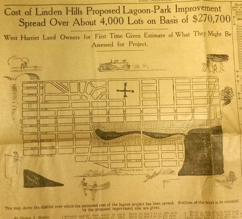
This drawing from a 1915 newspaper article shows the initial concept of a South Bay and outlines how it would be paid for. (Source: Minneapolis Sunday Tribune, June 20, 1915)
The challenge, of course was how to pay for it. The park board’s plan to assess property owners in the area for the expensive improvements was met with furiuos opposition and lawsuits. Many property owners thought that assessments they were already paying for acquisitions and improvements over the years at Lake Calhoun, Lake Harriet and William Berry Park were too heavy. The courts eventually decided in favor of the park board’s right to assess for those improvements, but by then estimated costs for the project had increased and become prohibitive and the South Bay scheme was abandoned.
Instead land for Linden Hills Park was acquired in 1919 and the surrounding wet land was drained into Lake Calhoun in the early 1920s. Dredged material from the lake was used to create a better-defined shoreline on the southwestern and northwestern shores of the lake in 1923 in preparation for the construction of the parkway.
Flowage Rights on the Mississippi River and a Canal to Brownie Lake
Minneapolis parks also lost land to water in 1916. The federal government claimed 27.6 acres of land in the Mississippi River gorge for flowage rights for the reservoir that would be created by a new dam to be built near Minnehaha Creek. Those acres, on the banks of the river and several islands in the river, would be submerged behind what became Lock and Dam No. 1 or the Ford Dam. In exchange for the land to be flooded, the park board did acquire some additional land on the bluffs overlooking the dam.
The other alteration in water courses was the dredging of a navigable channel between Cedar Lake and Brownie Lake, which completed the “linking of the lakes” that was begun with the connection of Lake of the Isles and Lake Calhoun in 1911. The land lost to the channel was negligible and probably balanced by a slight drop in water level in Brownie Lake. (A five-foot drop in Cedar Lake was caused by the opening of the Kenilworth Lagoon to Lake of the Isles in 1913.)
Another potential loss of water from Minneapolis parks may have occurred in 1917. William Washburn’s Fair Oaks estate at one time had a pond. I don’t know when that pond was filled. The estate became park board property upon the death of Mrs. Washburn in 1915. Perhaps in 1917 when the stables and greenhouses on the southwest corner of the property were demolished, the south end of the estate was graded and the pond was filled. Theodore Wirth’s suggestion for the park, presented in 1917, included an amphitheater in part of the park where the pond had once been.
The Dredge Report
The year 1917 marked the end of the most ambitious dredging project in Minneapolis parks — in fact the biggest single project ever undertaken by the park board until then, according to Theodore Wirth. The four-year project moved more than 2.5 million cubic yards of earth and reduced the lake from 300 shallow acres to 200 acres with a uniform depth of 15 feet.
That wasn’t the end of work at Lake Nokomis, however. The park surrounding the lake, especially the playing fields northwest of the lake couldn’t be graded for another five years, after the dredge fill had settled.
Dredging may again be an issue in 2017 if the Park Board succeeds in raising funds for a new park on the river in northeast Minneapolis. Dredges would carve a new island out of land where an old man-made island once existed next to the Plymouth Avenue Bridge. But that may be a long time off — and could go the way of South Bay.
Park Buzz
One other development in 1917 had more to do with standing water than was probably understood at the time. The Park Board joined with the Real Estate Board in a war on mosquitoes. However, after spending $100 on the project and realizing they would have to spend considerably more to achieve results, park commissioners terminated the project. It was not the first or last battle won by mosquitoes in Minneapolis.
As we look again at new calendars, it’s always worth taking a glance backward to see how we got here. For me, it is much easier to follow the course of events in Minneapolis park history than in American political history.
David C. Smith
Comments: I am not interested in comments of a partisan political nature here, so save those for your favorite political sites.
The Last of the Deluge: Minnehaha Creek Floods Meadowbrook Golf Course
Filed under: Minneapolis Golf Courses, Minneapolis parks, Minnehaha Creek | Tags: Hiawatha Golf Course, Meadowbrook Golf Course, Minnehaha Creek, Theodore Wirth Golf Course
Leave a comment Ok, enough about flood waters—but I had to post a couple more shots of water winning. These were taken at Meadowbrook Golf Course, the Minneapolis park course located in St. Louis Park and Hopkins on Excelsior Boulevard. (Click here to learn why the Minneapolis Park Board owns a golf course outside city limits. In fact, it owns four courses outside of Minneapolis: Theodore Wirth, Francis A. Gross, Fort Snelling and Meadowbrook.)

Meadowbrook Lake! Meadowbrook Golf Course — seen here from Excelsior Boulevard in St Louis Park — usually doesn’t have a lake in the middle of it. A pond on Minnehaha Creek on the eastern edge of the course — several hundred yards from this scene — was created in the late 1920s shortly after the course opened, because high water in the creek flooded part of the course. The pond was dredged to hold potential flood water and the earth dredged for the pond was used to raise the level of the course around it. That has worked pretty well through the history of the course — but not when Minnehaha Creek rises this much. This photo was taken more than a week after the heavy rains of June 19. (David C. Smith)
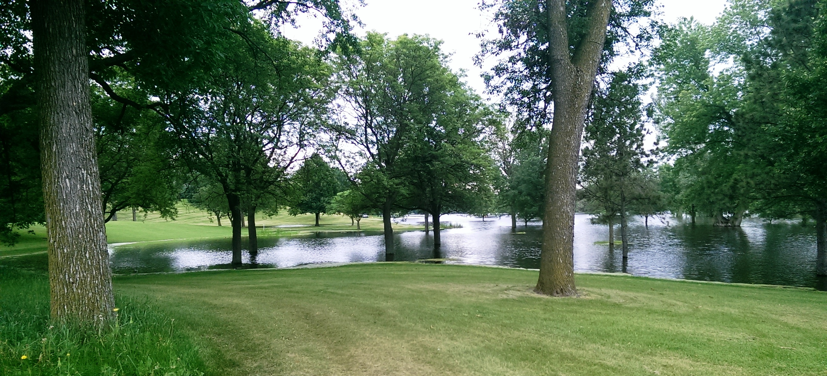
Another shot of the new lake in Meadowbrook Golf Course taken from near Excelsior Boulevard. (David C. Smith)

A different “lake” view, this looking east from Meadowbrook Road through the heart of the golf course. The 14 water hazards the course normally features appear to have merged into one. (David C. Smith)
As of this afternoon, the only Minneapolis public courses that remain closed due to flooding are Meadowbrook and Hiawatha. Only this afternoon, Theodore Wirth began allowing the use of carts again. There is no target date for when the two closed courses will reopen, but it’s likely to be awhile—especially with another 2-4 inches of rain forecast for this weekend.
Not only will cleanup and repair of these courses be expensive, but the revenue they typically generate will be lost to the Park Board for much of the summer.
David C. Smith
© 2014 David C. Smith
Bryn Mawr Golf Course Update
Filed under: Minneapolis Golf Courses, Minneapolis parks | Tags: Bryn Mawr, Golf, Interlachen Golf, Minikahda
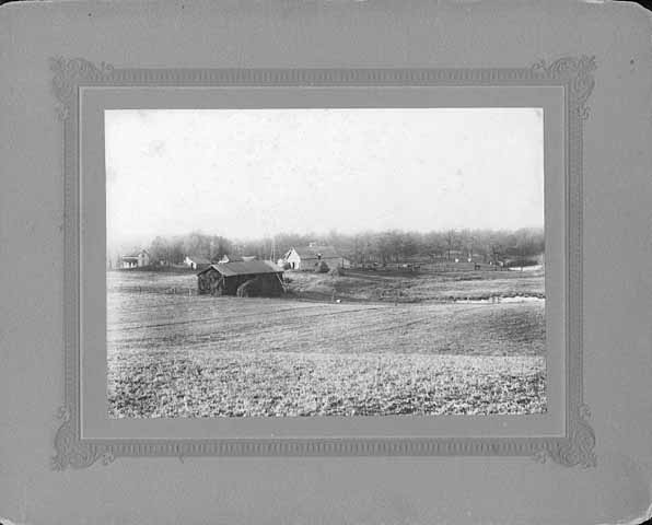
Comments (2) I recently met with Joe Bissen who is writing a book on lost Minnesota golf courses. We walked around the Bryn Mawr neighborhood trying to determine the location of the old clubhouses of the Bryn Mawr Golf Course. The course, which existed from 1898 to 1911 near the Penn Avenue-Cedar Lake Road intersection, spawned both the Minikahda and Interlachen clubs before it closed and the course disappeared.

Golfing at Bryn Mawr in 1898. (Minnesota Historical Society)
The Bryn Mawr course had two clubhouses. The first was located at 95 Elm Street, now Morgan Avenue South, which had been a private residence of the Woodburn family before it was purchased in 1898 and converted into a clubhouse. The second clubhouse was built nearby. Bissen has found the address of the second clubhouse in 1908 to be 97 Oliver Avenue North.
Here’s the challenge. At that time Superior Avenue, what is now roughly I-394, was the dividing line between north and south street addresses, but now that dividing line is about a half-mile north at Chestnut Avenue. What was once Oliver Avenue North in Bryn Mawr is now Oliver Avenue South. Can anyone shed light on the present address of what was once 95 Oliver Avenue North? Joe and I suspect it was in the 400 or 600 block of what is now Oliver Avenue South. (Futher complicating addresses in the neighborhood there are no 500 addresses—straight from 490s to 600s!)
Can any Bryn Mawr historians solve this puzzle? Let me know and I’ll put you in touch with Joe. Would property abstracts show old addresses? And why (when) was Bryn Mawr moved from north to south?
Joe Bissen is researching lost golf courses throughout the state, so if you know of other courses, such as the Camden Golf Club in north Minneapolis, which disappeared with hardly a trace, Joe would like to know more about them.
David C. Smith
Bombers Over Lake Nokomis
Filed under: Minneapolis Golf Courses, Minneapolis Lakes, Minneapolis parks | Tags: Hiawatha Golf Course, Lake Hiawatha, Lake Nokomis, Wold Chamberlain Field
Comments (2) My favorite photo of Lake Nokomis was taken in 1932. The true subject of the photo was a squadron of Martin bombers visiting Wold-Chamberlain Field from Langley Field, Virginia, but beneath them is a fascinating scene of park developments.

The Martin Bomber was the first American airplane built specifically to carry bombs. First built during WWI, the biplane version of the bomber was replaced by a monoplane version designed in 1932. (Minnesota Historical Society)
The photographer isn’t listed in the Minnesota Historical Society’s database, but it may have been taken by J. E. Quigley Aerial Photography. Quigley produced most of the other aerial photos of Minneapolis from that era.
The bare ground at the left wingtip of the middle plane is the Hiawatha Golf Course under construction. The course didn’t open until 1934. Dredging in Lake Hiawatha had just been completed in 1931.
It doesn’t show up well at this size, but the Nokomis Beach is packed (beneath the front airplane). You can see the diving towers in the lake.
Also note how barren the Nokomis lakeshore is. It had been created from lake dredgings only 15 years earlier.
Four years after dredging was completed at Lake Nokomis and the dredge fill had settled, the park board cleared and graded the land. (Minneapolis Park and Recreation Board)
The dredge fill settled for four years before it was cleared of brush and willows that had grown up in the intervening years and the land was graded for athletic fields. The huge piles of brush in the background were burned. Of course the land was graded by horse teams. Even with that much time for the dredge fill to settle before it was graded, the playing fields continued to settle and were re-graded in the 1930s as a WPA project.
Even after ten years of tree growth, the lake shore doesn’t look very shaded in the 1932 photo.
The Cedar Avenue Bridge at the bottom of the aerial photo was the subject of great debate at the park board, Minneapolis City Council, the Hennepin County Board and Village Council of Richfield in the 1910s. Park superintendent Theodore Wirth’s plan for the improvement of Lake Nokomis in the 1912 annual report included rerouting Cedar Avenue around the southwest corner of the lake to eliminate a “very unsightly” wooden bridge over the edge of lake at the time. Even though the park board owned all the shores of the lake and the lake bed, the south end of the lake was then in Richfield, which is why the county and Richfield were involved in decisions on the bridge. Despite the park board position that building a bridge would be more expensive and less attractive, it was built—and paid for with Minneapolis bond funds—partly due to opposition by Richfield landowners to plans to reroute Cedar. By 1926 that line of opposition would have been partially removed when Minneapolis annexed about a mile-wide strip of Richfield that placed all of Lake Nokomis inside Minneapolis city limits.
David C. Smith
Minneapolis Park Memory: Treasure
Filed under: Minneapolis Golf Courses, Minneapolis Park Memory, Minneapolis Parks: General | Tags: Hiawatha Golf Course, Lake Harriet, Minnehaha Park, Powderhorn Park
Comments (1) How I have enjoyed the Minneapolis parks: watching fireworks at Powderhorn Park; concerts at Lake Harriet, with picnics on the hill; swimming and canoeing at Calhoun; walking in Minnehaha Park and eating crab cakes at Sea Salt; walking and biking at Nokomis; watching my children play hockey at various parks, and baseball at McRae and Diamond Lake; teaching the children to skate at Diamond Lake; my sons in their early teens taking the bus from our home at 48th and Clinton all the way to Theodore Wirth Park to play golf; my boys golfing at Hiawatha and telling us that they played with two really nice “old guys.” (These “old guys” happened to be friends of ours from church and were our age, in their 40s.)
My son Glen would leave the house in the summer early in the morning, bike to Lake Harriet with his fishing equipment, climb on a tree branch overhanging the lake and stay until suppertime. He enjoyed being outdoors even if he didn’t catch fish.
But here is my most treasured memory: In 1945, my future husband took me canoeing at Calhoun and then into Lake of the Isles, and gave me my engagement ring.
Alice Streed

The Romantic Route (from City of Parks, Minneapolis Park and Recreation Board)
First African-American golfers in Minneapolis
Filed under: Minneapolis Golf Courses, Minneapolis Parks: General | Tags: Minneapolis golf, Minneapolis parks
Leave a comment I don’t have plans to write more about the first private golf courses in the Minneapolis area, as noted in my last post, but I do have interesting information on the creation of the first public golf courses in Minneapolis parks. Someday.
I’ll also write about efforts to integrate the private golf clubs that operated out of Minneapolis park golf courses in the early 1950s. At the center of that story were representatives of the Twin City Golf Association, an organization of black golfers — Frederic Jones, Bert Davison, John Williams, L. Howard Bennett and others — and one of the more colorful park commissioners ever, Ed Haislett. Haislett was a boxing champion, a professor, and the author of a book on boxing that was plagiarized by martial artist movie star Bruce Lee. How’s that for a resume?
Minneapolis Golf Clubs Go To War
Filed under: Minneapolis Golf Courses, Minneapolis Parks: General | Tags: Minneapolis golf, Theodore Wirth Park
Comments (2) One more bit of information about the oldest golf courses in Minneapolis, then I’ll move on.
I found this item in The American Golfer, June 1917:
“Four private golf clubs in Minneapolis are going to utilize a portion of their grounds for raising foodstuffs this summer. At the University Club more than 25 acres will be plowed up. The Minneapolis Club has set aside 4 acres for potatoes, and Interlachen and Minikahda will devote all available spaces to small garden truck. One hunderd caddies of the Town and Country Club have organized a military company.”
The actions were in response to the United States entry into the “Great War” in April 1917.
The golf course at the University of Minnesota and the first public golf course in Minneapolis—at Glenwood Park, now Theodore Wirth Park—had only opened in 1916. Both courses were nine holes at that time.
After the Minneapolis Board of Park Commissioners opened the Glenwood golf course in June, 1916, The American Golfer noted that only Oakland and Portland among “western” cities did not have municipal golf courses.
David C. Smith
The Mother of All Minneapolis Golf Courses: Bryn Mawr II
Filed under: Minneapolis Golf Courses, Minneapolis Parks: General | Tags: Bryn Mawr, Interlachen Club, Minikahda Club, Minneapolis golf, Minneapolis parks, Theodore Wirth Park
Comments (3) When the golf and social activities of the Bryn Mawr Club shifted to the newly opened Minikahda Club at Lake Calhoun in July 1899, the Bryn Mawr golf course and club house didn’t stand empty for long. Two weeks after the Minikahda Club opened—and promptly became the hub of Minneapolis social life—golfers were already at work to get back on the Bryn Mawr links.
The Minneapolis Tribune on August 9, 1899 attributed the interest in reviving a golf club at Bryn Mawr to “young businessmen who find the Minikahda links at too great a distance from the city.” The paper speculated that the organizers of the new club also expected that the links could be used “at comparatively little expense.” A meeting of those interested in organizing the new club was announced at the West Hotel.
In a little more than a week, the new Bryn Mawr Golf club had been officially created with a membership limit of 200 (compared to Minikahda’s 700) and initiation fees of $10 for men and $5 for women. Curiously, the club was organized as a corporation that was to be limited to ten years. Why that provision, reported in the Tribune of August 18, was made in the club’s organization eludes me, unless it could have been based on a lease for the land. That provision may have been a factor in the creation of another well-known club when those ten years were up.
Initial reports were that the new club would also use the old club house, but that didn’t last long. By the time the new club held its annual meeting on March 19, 1900 prior to its first full season in operation, it already had architectural plans drawn for a new two-story club house that would cost about $2,000. It had “all the necessary adjuncts of a modern club on a small scale,” according to the Tribune.
One reason for the new club house and perhaps a reason the old club house’s previous occupants abandoned it for new digs at Lake Calhoun was revealed when the Minneapolis Tribune reported that the new Bryn Mawr club house would be “erected near the green, so as to avoid the lengthy walk occasioned by the location of the old club house.”
The exact location of the new club house wasn’t cited, but was evidently nearer the present intersection of Laurel and Cedar Lake Road than the earlier Elm Street address. The new club also lengthened two holes at Bryn Mawr making the course a few hundred yards longer. Despite the increased length, the “bogey” for the course (par) was reported in the Tribune as 38, or seven strokes lower than the bogey score when the course was established two years earlier. The Tribune also reported that club member F. A. Stuart had already posted a course record of 42. Players were clearly getting better.
The new club hired a part-time instructor, Martin Watson, who split his time between the Bryn Mawr course and the brand new Lafayette Club course on Lake Minnetonka. Martin was the brother of Minikahda pro William Watson.
The other big golfing news of 1900 in Minneapolis was foreshadowed by an article in the Minneapolis Tribune, June 17, 1900, which reported that Minneapolis Mayor James Gray had tried his hand at golf for the first time at a new St. Paul course at Merriam Park. (The course was bounded by Selby, Summit, Snelling and Prior.) The humorous piece detailed Gray’s adventures on the new course. The afternoon of golf must have made a big impression on His Honor because Harper’s Official Golf Guide, published in 1901, listed a Lake Harriet Golf Club in Minneapolis organized in September, 1900. The listing for the club included Mayor Gray as a “Principal Member.” The listing for the club and its “nine-hole course” in the guide provides no information on the location of the course.
(I can find no other mention of a proposed or actual course anywhere near Lake Harriet. If any readers have more info, I’d love to know.)
The Bryn Mawr course was often referred to in the press as the “businessman’s course.” Newspaper accounts of local golf competitions among clubs noted also that some golfers were members of both Minikahda and Bryn Mawr. Although Bryn Mawr never promoted the social aspects of club life as Minikahda did, the club did expand its offering in 1900 with the addition of two tennis courts and a handball court.
The end of the Bryn Mawr Golf club was announced in the September 4, 1909 issue of the Minneapolis Morning Tribune. “When the Bryn Mawr Golf club closes its present season it will move from its grounds…and next year will find the home of this socio-athletic organization farther out in the country,” the paper reported. The paper speculated that grounds would be found beside Lake Minnetonka. It claimed that the old Bryn Mawr clubhouse site would be taken over by a newly organized tennis club.
In late November, however, the Morning Tribune reported quite a different location for the new club. “Options have been secured by the Bryn Mawr Golf club on 150 acres of land bordering Mirror Lake, three miles beyond the Harriet loop and bonds are being sold to enable the promoters to consummate the deal,” the newspaper reported on November 28. The Bryn Mawr Golf club was about to transform into Interlachen Country Club.
The little $2,000 club house at Bryn Mawr was scheduled to be replaced by a $25,000 club house (soon increased to $30,000) at what would become Interlachen. By January 9, 1910 the newly organized Interlachen club announced that it had acquired 146 acres of land between the Brookside and Mendelsohn stations on the Minnetonka streetcar line for the new country club at a cost of about $55,000. Golf play continued at Bryn Mawr for the 1910 season while the new course and club house were being constructed.
The demise of the Bryn Mawr Golf club was best described by a golf columnist of the Minneapolis Morning Tribune, May 14, 1911. “The cozy little club with its congenial membership was crowded out by the growth of the city,” he wrote, “and thus passed into history an organization which was within the reach of the small salaried man and yet claimed as members some of the most prominent businessmen of the city.” The Tribune’s golf writer, George Rhame, who was a member of Bryn Mawr and Interlachen wrote in 1913 that Bryn Mawr had “passed into history when the sporty little nine hole course was cut up into building lots.”
With the formal opening of Interlachen Country Club in late July 1911 it became the second child of the nine-hole course and club at Bryn Mawr. Two of the oldest and most prominent private clubs in the Minneapolis area were both given life by Bryn Mawr, the modest little club that could be reached by streetcar.
It’s interesting to note that the location of Interlachen, one of the most prestigious country clubs in the area, was chosen partly because it was accessible by streetcar. “The Bryn Mawr club was one of the most representative clubs in the city, likewise it was democratic,” wrote the Minneapolis Morning Tribune on May 8, 1910. “The necessity arose for more grounds and while the desire was for a country club, it was also requisite that a site should be selected within reach of the members who depend on the street cars for transportation.”
I don’t suppose Interlachen has many members these days who take the bus to play a round of golf.
At about the time that the Bryn Mawr golf course went out of business, the Minneapolis park board was acquiring land nearly surrounding the old course. In 1908 the park board purchased more than 500 acres to add to Glenwood (Wirth) Park west of Bryn Mawr. In 1911 it purchased most of the land for what is now Bryn Mawr Meadow Park. The remaining land along Bassett’s Creek between Bryn Mawr and Glenwood was acquired by purchase and donation in the 1930s.
In the mid-1920s the Minneapolis Board of Park Commissioners added what was then it’s fourth golf course, Meadowbrook, next door to Interlachen.
David C. Smith
The Mother of All Minneapolis Golf Courses: Bryn Mawr I
Filed under: Bryn Mawr, Lake Calhoun, Minneapolis Golf Courses, Webber Park | Tags: Bryn Mawr, Lake Calhoun, Minikahda Club, Minneapolis golf, Minneapolis parks
Comments (2) The first golf course in Minneapolis was not Minikahda. A year before Minikahda opened, many of its members, Minneapolis’s highest society, played at a course much closer to the central city. The first Minneapolis golf course and club were in Bryn Mawr. The course didn’t last long, a little more than 10 years, but it did spawn two of the more famous golf courses in Minnesota: Minikahda and Interlachen.
When I discovered Warren Manning’s proposal for a public golf course at The Parade in 1903, I became curious about the first golf played in Minneapolis. I wanted to know what led up to the park board creating the first public golf course at Glenwood (Wirth) Park in 1916. I was surprised to learn about courses, or plans for them, at four locations in the city by 1900. The only one that still exists is Minikahda, which overlooks Lake Calhoun.
The first mention I can find of a golf course in Minneapolis — St. Paul already had Town and Country just across the Mississippi River at Lake Street — was in a Minneapolis Tribune article from April 23, 1898, which noted that twenty men who were interested in golf and wanted links closer than Town and Country had met at the West Hotel on Hennepin Avenue for the purpose of forming a Minneapolis golf club. The paper reported, “The grounds proposed are in Bryn Mawr and the high land west, ideal in location and well adapted to links, with sufficient hazards to make the game interesting.” The article also mentioned that the course was advantageously placed near the streetcar line, which ran out Laurel Avenue.
Less than two weeks later, the Tribune reported that the Minneapolis Golf Club had been formally organized, the links were almost ready for play, and a greenskeeper—Scottish, of course—had been hired away from the Chicago Golf Club in Wheaton, Illinois. He called the new course the “best inland links he had seen,” according to a Tribune article a few days later.
The Bryn Mawr clubhouse was formally opened on June 18. The Tribune reported the next day that several hundred people attended. “An orchestra greeted the visitors with music,” wrote the Tribune, “and there was a stream of handsome turnouts over the Laurel avenue bridge, bringing the women in their lovely summer frocks to smile on the men in their gay golfing suits.”
The nine-hole course measured a bit over 2300 yards with only two holes longer than 300 yards. The first tee was west of the clubhouse and the first green was on the east side of Cedar Lake Road. The second green was across that highway and a small pond.
Par for the course, at that time referred to as “bogey,” was set at 45 strokes. That must have seemed an impossible achievement for club members, based on early scores. At the first handicap tourney on the day the clubhouse opened, Martin Hanley beat a field of 40 golfers for the prize of a box of gutta percha balls. His net score was 101. Adding his handicap of 30, he had actually played the course in 131 strokes! That’s not three over par, it’s nearly three times par. The game was young. Hanley remained one of the club’s top golfers after the club moved to Minikahda.
It’s worth noting that the most thorough description of the new course and club appeared on May 15, 1898 in the Tribune’s society column, not its sports pages. The list of the first 200-plus members reads like a who’s who of early Minneapolis society: Pillsbury, Peavey, Heffelfinger, Jaffray, Rand, Lowry, Bell, Dunwoody, Christian, Morrison, Koon, Loring. The original plan was to admit 150 men and 100 women as members, but the initial number of female applicants was a bit lower than expected at only 62.
The new club had not only a course and greenskeeper, but a club house. The Woodburn residence had been “secured” for that purpose. The clubhouse featured “capacious rooms” and “broad verandas” and was being renovated to provide locker rooms and a restaurant. The location of the clubhouse is indicated by a report in the Saint Paul Globe of July 27, 1898 of a fire at the “quarters of the Bryn Mawr Golf club at the rear of 95 Elm Street.” Elm Street was later renamed Morgan Avenue North. So what was then 95 Elm Street would now likely be in Bryn Mawr Meadows—but that was more than ten years before Bryn Mawr Meadows was a park. The Globe reported that the total loss from the fire was not expected to exceed $200, so it was not likely a factor in the decision of the club to build a new clubhouse in a new—and now famous—location the next year.
Over the winter the members of the Bryn Mawr golf club must have become dissatisfied with the course or clubhouse or both, because the membership built a new golf course and a much grander clubhouse near the western shore of Lake Calhoun, the Minikahda Club.
On June 25, 1899 the Minneapolis Tribune reported, “Although somewhat late in starting its tournament season, the golf club which is now using the Bryn Mawr links until the Minikahda links are completed, had its tournament yesterday afternoon.” Some of the golfers at the club must have been quick learners, because early in the club’s second season scores had dropped dramatically. C. T. Jaffray won the opening tournament with a score of 85. The Tribune noted that the club was looking forward to the opening of the Minikahda clubhouse in “about three weeks.”
Roughly on schedule, the Tribune announced on July 14, “the activities that have centered around the Bryn Mawr links since the first of the season will be transferred tomorrow afternoon to the Minikahda links…The new club house on the west shore of Lake Calhoun is practically finished.”

That was not the end of the Bryn Mawr golf links, but before it was resurrected another Minneapolis golf course emerged. “The Camden Park golf club has been organized among the young men in the employ of the C. A. Smith Lumber company,” the Minneapolis Tribune reported on July 21, 1899. The new club had a membership of 25 and growing. “It plays over a beautiful course of nine holes laid out in the Camden park region and crosses the creek three times,” wrote the Tribune. The reference must have been to Shingle Creek.
As with the Bryn Mawr course, it is not clear that the club owned the land on which it had laid out its holes. Although the Tribune noted that the new club was “particularly fortunate in its course” and that the club “anticipates becoming a large and influential organization some day,” this article is the only mention I can find in Minneapolis newspapers of a golf course in north Minneapolis. A description of the course was included in Harper’s Official Golf Guide published in 1901, with distances and “bogey” for nine holes and the clubs officers. Based on newspaper descriptions of a course that crossed a creek, the course was perhaps laid out on land that became part of Camden (Webber) Park when the park board acquired land for that park in 1908.
Next: The Mother of All Minneapolis Golf Courses: Bryn Mawr II. A new Bryn Mawr Golf Club leads to yet another famous club.
David C. Smith
Was landscape architect Warren Manning the first to propose a public golf course in a Minneapolis park?
Filed under: Landscape Architects, Minneapolis Golf Courses, Minneapolis Parks: General | Tags: Horace Cleveland, Minneapolis golf, Minneapolis parks, Sculpture Garden, The Parade, Thomas Lowry, Warren Manning
Comments (2) Under the headline “Fine Park Is Assured”, the Minneapolis Tribune ran a story on November 15, 1903 that contained details I had never seen on plans for a golf course and baseball field in a Minneapolis park. The basic facts of the article are well-known: Thomas Lowry, along with William Dunwoody and Seurity Bank, offered to donate land at the foot of Lowry Hill for what eventually became The Parade.
What was new (to me) in the story was that when Lowry submitted his proposal to donate land down the hill from his mansion he also submitted designs for the park. The plans were prepared by well-known landscape architect Warren Manning at Lowry’s request. Lowry also offered to foot the cost of implementing Manning’s plan. Lowry eventually did donate thousands of dollars to help the park board convert the land to a park, but Manning’s plans were never mentioned in park board records.
Continue reading
