Archive for the ‘Minnehaha Creek’ Category
Ironing Out Minnehaha Creek’s Wrinkles
Filed under: Minneapolis parks, Minnehaha Creek, Minnehaha Falls | Tags: Minnehaha Creek
 Comments (4)
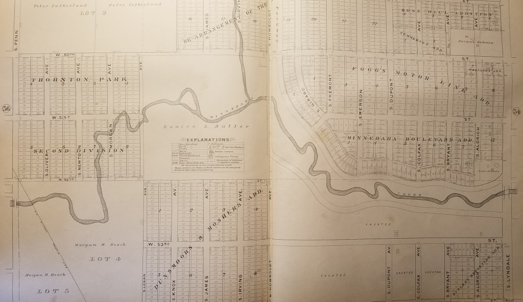
 A reader checked in a few weeks ago with a question: Did Minnehaha Creek ever cross West 54th Street in the southwest corner of Minneapolis?
I pulled out my 1903 Minneapolis Real Estate Atlas and was surprised to find that the creek did cross what is now West 54th St. for a few hundred feet. At that time, 54th St. was the southern city limit of Minneapolis.

The park board didn’t acquire this section of Minnehaha Creek — from Humboldt to Zenith — until 1930, and graded and straightened sections of the creek in 1932. The creek would have been straightened here as elsewhere to avoid the expense of building bridges. (Read more about the acquisition and development of this section of Minnehaha Creek. Go to the “History” tab at the bottom of the page.)
The section of Minnehaha Creek acquired in 1930 never had a parkway built along it as was done east of Humboldt. That was partly because some homes had already been built near the creek and also because the creek banks were much steeper here than to the east. But even if it had been perfectly flat and unoccupied, the Great Depression had set in so there was no money for new parkways.
According to Hennepin County property records the first house along this section of W. 54th St. was not built until 1942. That was a rarity because very few houses were built in Hennepin County during World War II due to a shortage of labor and materials. The rest of the houses along the street were built after the war, mostly from 1948 on.
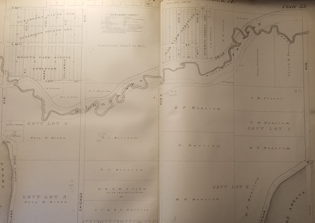
What other changes were made to the course of Minnehaha Creek over the years? Here are three other sections of the creek from the 1903 atlas that you can compare to Google Maps to see what’s changed. Most of the changes were made in the 1920s partly to make it easier to improve the parkway to accommodate car traffic and partly to shorten the course of the creek to try to increase water flow over Minnehaha Falls in drought years — which was most years in the 1920s-1950s. No one seemed to like an empty creek and dry falls.

You can view many other early maps of Minneapolis — and spend hours and hours of COVID-avoidance free time — at the University of Minnesota’s John Borchert Map Library website. Countless maps — and aerial photography as well. You’ll be happier and smarter. Stay healthy.
David Carpentier Smith
Accept When Offered: A Brief History of Minnehaha Parkway
Filed under: Minneapolis parks, Minnehaha Creek, Minnehaha Falls | Tags: Charles M. Loring, Horace Cleveland, Minnehaha Creek, Minnehaha Parkway history, Theodore Wirth
Comments (3) Given recent discussion of the history of Minnehaha Parkway, I thought it might be useful to consider a brief timeline of when and why the parkway was acquired by the Minneapolis Board of Park Commissioners and how it was developed. I wrote some of this for the Minneapolis Park and Recreation Board in 2008, but it is not presently accessible at minneapolisparks.org. Most other individual park histories, such as Minnehaha Park, are available there under the “History” tab on each park page. I would encourage you to read them.
Park board records do not reveal the origin of the idea of a parkway along the valley of Minnehaha Creek. The first mention of a park along the creek is in the park board proceedings of October 8, 1887 when, after hearing from “interested parties,” the park board resolved that when lands along Minnehaha Creek “are offered, they be accepted” between Lake Harriet and the Soldier’s Home. (The Soldier’s Home was then planned to be built at the mouth of Minnehaha Creek on the Mississippi River on land donated to the state by the city. Minnehaha Falls was not yet a park, although it was in the works.) As part of the resolution, the park commissioners expressed their intent to create a parkway beside the creek when they deemed best to do so—meaning if they ever had the money.

An early 1900s postcard image of the parkway and path at an unknown location. Don’t you want to follow that path? It’s a favorite image I included in City of Parks: The Story of Minneapolis Parks
Today Minnehaha Parkway begins at Lake Harriet Parkway on the south shore of Lake Harriet and Continue reading
Shared History: Edina’s Early Days
Filed under: Lake Harriet, Landscape Architects, Minneapolis Parks: General, Minnehaha Creek | Tags: Edina History, H.W.S. Cleveland, Horace Cleveland, Minnehaha Creek
Comments (4) Edina and Minneapolis share more than France Avenue—and history buffs aren’t restricted by city boundaries.
Henry Brown played an important role in the history of Edina as well as the history of Minnehaha Falls as a Minneapolis park.
There is a Chowen Park in both Edina and Minneapolis.
Minnehaha Creek flows through Minneapolis parkland before it gets to Edina — and, of course, all of Minnehaha Creek after it leaves Edina on its way through Minneapolis to Minnehaha Falls and the Mississippi River is parkland.
The Interlachen neighborhood grew up around a golf course created by golfers who had outgrown their nine-hole Bryn Mawr course near downtown Minneapolis.
That’s just a taste of the rich information on Edina history—and Minneapolis history— on the web site of realtor Ben Ganje. Go to the neighborhood directory on his site then look at the right margin for a list of Edina neighborhoods. Each of Edina’s 45 official neighborhoods is profiled with historical info and interesting bits of trivia.
I read about Todd Park because of my interest in famous diva Emma Abbott, a Minneapolis girl made good. Her father was one of those first interested in developing this part of Edina.
Why was I interested in Emma Abbott? She was buried next to her husband in Oak Grove Cemetery in his home town, Gloucester, Mass. Their monument is the most impressive in that cemetery, which I visited this fall.

Emma Abbott’s memorial in Oak Grove Cemetery, Gloucester, Mass. Designing the cemetery was one of H.W.S. Cleveland’s first commissions as a landscape architect in 1854. (Photos: David C. Smith)
Laying out Oak Grove Cemetery was one of the first commissions Horace William Shaler Cleveland received as a landscape architect.  He was hired for that job, with his young partner Robert Copeland, in 1854. The next year they tackled the design of the much more prestigious Sleepy Hollow Cemetery in Concord, Mass., the eventual resting place of many of the great writers of early America: Ralph Waldo Emerson, Henry David Thoreau, Louisa May Alcott, Nathaniel Hawthorne and his wife, Sophia, who was a childhood friend of Horace Cleveland.
More Edina History of Interest to Minneapolitans
Another Edina neighborhood profile I liked was Creek Knoll, which borders Minneapolis and was first promoted as a residential development for its nearness to Lake Harriet.
Also check out the profile of Morningside, a neighborhood that was also subdivided and developed partly because of the rapidly rising prices of residential lots nearer Lake Harriet in the early 1900s.
For those of you interested in park history in general, you might want to read about park development at Pamela Park, Bredesen Park and also the land once owned by four-term Minneapolis mayor, George Leach, that became Braemar Golf Course. The Lake Cornelia history also presents some of the challenges of park making as well as stormwater management that face cities as well as suburbs.
Can you still catch northern pike in Centennial Lakes?
Worth a look if you want to know more about our southwestern neighbor—and our metropolitan area from water management and freeways to shopping centers.
David C. Smith
The Last of the Deluge: Minnehaha Creek Floods Meadowbrook Golf Course
Filed under: Minneapolis Golf Courses, Minneapolis parks, Minnehaha Creek | Tags: Hiawatha Golf Course, Meadowbrook Golf Course, Minnehaha Creek, Theodore Wirth Golf Course
Leave a comment Ok, enough about flood waters—but I had to post a couple more shots of water winning. These were taken at Meadowbrook Golf Course, the Minneapolis park course located in St. Louis Park and Hopkins on Excelsior Boulevard. (Click here to learn why the Minneapolis Park Board owns a golf course outside city limits. In fact, it owns four courses outside of Minneapolis: Theodore Wirth, Francis A. Gross, Fort Snelling and Meadowbrook.)

Meadowbrook Lake! Meadowbrook Golf Course — seen here from Excelsior Boulevard in St Louis Park — usually doesn’t have a lake in the middle of it. A pond on Minnehaha Creek on the eastern edge of the course — several hundred yards from this scene — was created in the late 1920s shortly after the course opened, because high water in the creek flooded part of the course. The pond was dredged to hold potential flood water and the earth dredged for the pond was used to raise the level of the course around it. That has worked pretty well through the history of the course — but not when Minnehaha Creek rises this much. This photo was taken more than a week after the heavy rains of June 19. (David C. Smith)
Another shot of the new lake in Meadowbrook Golf Course taken from near Excelsior Boulevard. (David C. Smith)

A different “lake” view, this looking east from Meadowbrook Road through the heart of the golf course. The 14 water hazards the course normally features appear to have merged into one. (David C. Smith)
As of this afternoon, the only Minneapolis public courses that remain closed due to flooding are Meadowbrook and Hiawatha. Only this afternoon, Theodore Wirth began allowing the use of carts again. There is no target date for when the two closed courses will reopen, but it’s likely to be awhile—especially with another 2-4 inches of rain forecast for this weekend.
Not only will cleanup and repair of these courses be expensive, but the revenue they typically generate will be lost to the Park Board for much of the summer.
David C. Smith
© 2014 David C. Smith
Mississippi River flood
Filed under: Minneapolis parks, Minnehaha Creek, Minnehaha Falls, Mississippi River | Tags: Ford Dam, Minnehaha Falls, Mississippi River
Leave a comment Saturday afternoon I spent a bit more time looking at high water around the city. On that gorgeous afternoon, Minneapolis parks were heavily patronized, partly because of the beautiful day and partly because people were curious about the effects of our summer deluge.
The banks of the Mississippi River that I helped clean in April were under water again. Maybe when these flood waters subside, Friends of the Mississippi River should sponsor another trash pick up. Or we could each take a trash bag along when we go out for riverside hikes.
More evidence of high water on the big creek at the Ford Dam.

High water over the Ford Dam, June 21, 2014. Late last summer, there was no water flowing over the dam and below the dam was mostly dry land. (David C. Smith)

Last summer you could walk from the locks to the island where the submerged trees are now. The Ford Dam is just to the left of this photo. (David C. Smith, June 21, 2014)
Both photos were taken from the bluff at Minnehaha Park and the Soldiers Home. Water levels in Minnehaha Creek had subsided little, if at all, from Thursday to Saturday. Water was still thundering over Minnehaha Falls.
David C. Smith
Minnehaha Falls and Creek: Flood Stage
Filed under: Minneapolis Lakes, Minneapolis parks, Minnehaha Creek, Minnehaha Falls | Tags: Hiawatha Golf Course, Minnehaha Creek, Minnehaha Falls, Minnehaha Parkway
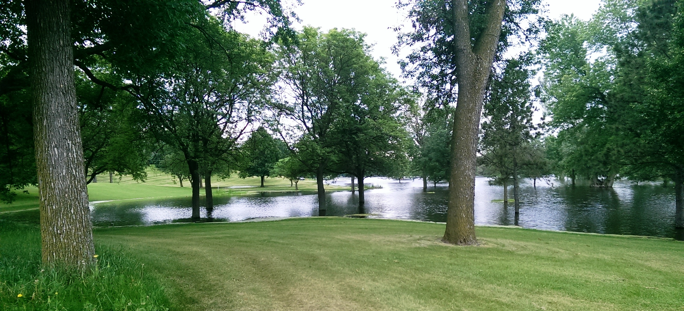
Comments (10) As we await another early evening thunderstorm, I will post a few historic photos of Minnehaha Creek and Minnehaha Falls taken earlier this afternoon. I call them historic because I’ve never seen the creek this high. One man I encountered on my explorations claimed it was a record water level for the creek. I’ll have to look that up.
The entire length of the creek was flooded, of course, even a few hours after the rain had stopped, but these three photos establish landmarks.

The bridge to nowhere. The creek normally flows under the bridge near the top of the photo. Minnehaha Parkway at Humboldt Avenue South, south of the Lynnhurst Recreation Center. (David C. Smith)
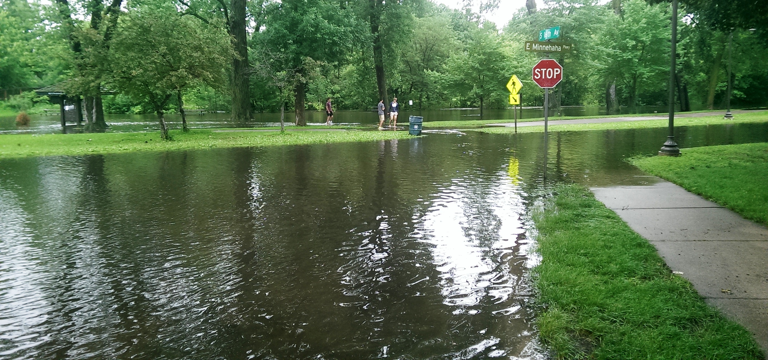
Minnehaha Parkway at 16th Avenue South. (David C. Smith)

Looking west on Minnehaha Parkway at Cedar Avenue South. (David C. Smith)
A man I met near Cedar Avenue claimed that the water reached a similar level after a 1988 thunderstorm, but the water subsided very quickly. Today it didn’t. Minnehaha Parkway was barricaded at many points east of Lake Harriet.

More than a water hazard. Hiawatha Golf Course looking south from E. 43rd Street near Standish. That is not Lake Hiawatha in the foreground. (David C. Smith)

A romantic interlude at the famous rapids of Minnehaha Creek! This is only a few yards upstream from the Hiawatha statue. (David C. Smith)
Some early descriptions of the Falls mentioned the heavy mist generated by the falls. That was true today. There was no rain falling while I was taking the pictures below, but I could feel the water in the air. Not quite as dramatic as Victoria Falls, where the cloud of mist over the falls is visible for miles — it’s called Mosi-o-Tunya, the Smoke that Thunders — but still impressive for this normally modest stream in mid-summer.
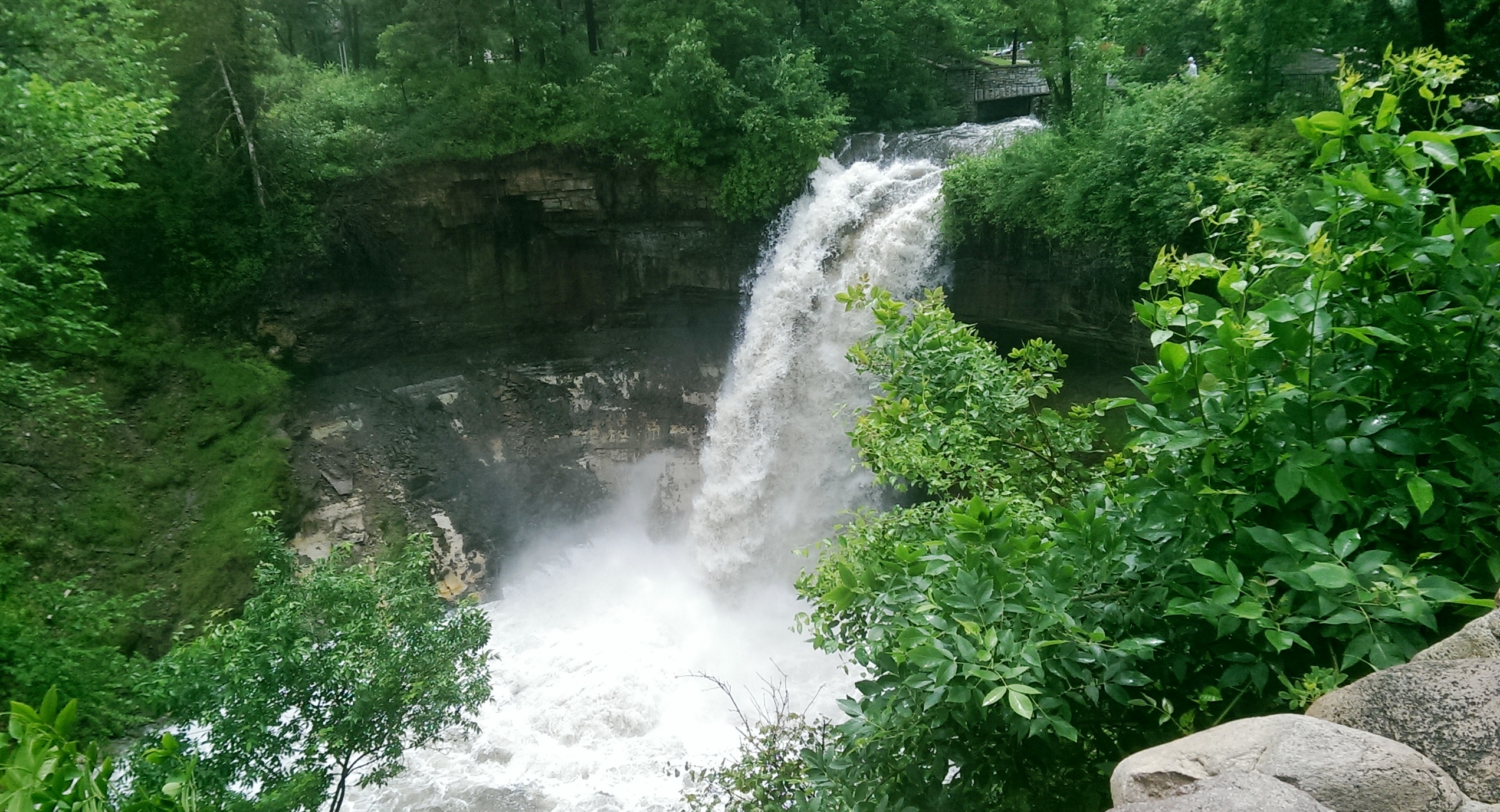
The falls made famous by Henry Wadsworth Longfellow. I recently discovered startling early plans for the park at the falls that I am waiting for permission to reveal. Stay tuned. (David C. Smith)
Unfortunately such high water levels, like the strong winds of recent years, require expensive cleanup efforts from the park board, stretching already tight park maintenance budgets. Kudos and thanks to the park board crews that will put our water-logged parks in beautiful condition yet again.
David C. Smith
© David C. Smith
Does anyone have any pictures to post of Bassett’s Creek in Theodore Wirth Park or downstream to Bryn Mawr before it dives underground? Is Shingle Creek any better?
CMPC: Park Property Monuments?
Filed under: Minneapolis parks, Minnehaha Creek | Tags: Minnehaha Creek
Comments (5) This week I was included in an e-mail discussion between MaryLynn Pulscher and Annie Olson at the park board and Daniel Fearn. Daniel had found two interesting metal markers in the ground near Minnehaha Creek.

Marker near Minnehaha Creek (Daniel I. Fearn)
Daniel wondered if CMPC was an acronym for City of Minneapolis Park Commission. My reaction, as well as MaryLynn’s, was that wasn’t likely because the park board until 1969 always marked everything BPC for “Board of Park Commissioners.” The Minneapolis was generally understood.
A web search, however, turned up a document from a Hennepin County Survey that indicates the CMPC stamp may have been used on park board survey monuments. On that document a monument with a similar marker found at 50th and Cedar during the Minneapolis City Survey in 1937 was called a “park board monument”
Do you know the real story of the CMPC markers? Have you seen other markers like this anywhere else in the city? Were they on park boundaries? Or do I have to call the county surveyor’s office to resolve this?
Send photos if you have ’em.
David C. Smith
More Bassett’s Creek
Filed under: Minneapolis parks, Minnehaha Creek | Tags: Bassett's Creek, Minnehaha Creek, Neiman Sports Complex
Leave a comment Interesting thoughts from readers on city and park board treatment of Bassett’s Creek:
Is it possible that Minneapolis spent as much or more tunneling Bassett’s Creek in an attempt to improve north Minneapolis than it spent building a parkway along Minnehaha Creek? Someone would have to go through financial reports to determine the city/Bassett’s Creek figures. Building two tunnels, the second one 80 feet beneath downtown Minneapolis, must have had a fairly hefty price tag. What if you threw in the federal and park board dollars from the time of Civilian Conservation Corps and Works Progress Administration projects in the 1930s until now on Bassett’s Creek above ground from Bryn Mawr into Theodore Wirth Park?
Perhaps the park board’s biggest missed opportunity in dealing with Bassett’s Creek was the decision to build a competition-quality youth sports complex—the one named for Leonard Neiman—at Fort Snelling instead of in Bryn Mawr/Harrison. I don’t recall what Bryn Mawr or Harrison residents thought of the idea when it was considered in the late 1990s. Does anyone remember that discussion? It would certainly be a better location for youth sports than the distant fields of Fort Snelling (for people living almost anywhere in Minneapolis—south, north, northeast, or southeast). Whether building that complex in the central city would have spurred other development or at least raised awareness of Bassett’s Creek is hard to say, but it could’ve been positive for the neighborhoods beside and above the creek.
David C. Smith

