Minnehaha Falls and Creek: Flood Stage
As we await another early evening thunderstorm, I will post a few historic photos of Minnehaha Creek and Minnehaha Falls taken earlier this afternoon. I call them historic because I’ve never seen the creek this high. One man I encountered on my explorations claimed it was a record water level for the creek. I’ll have to look that up.
The entire length of the creek was flooded, of course, even a few hours after the rain had stopped, but these three photos establish landmarks.

The bridge to nowhere. The creek normally flows under the bridge near the top of the photo. Minnehaha Parkway at Humboldt Avenue South, south of the Lynnhurst Recreation Center. (David C. Smith)
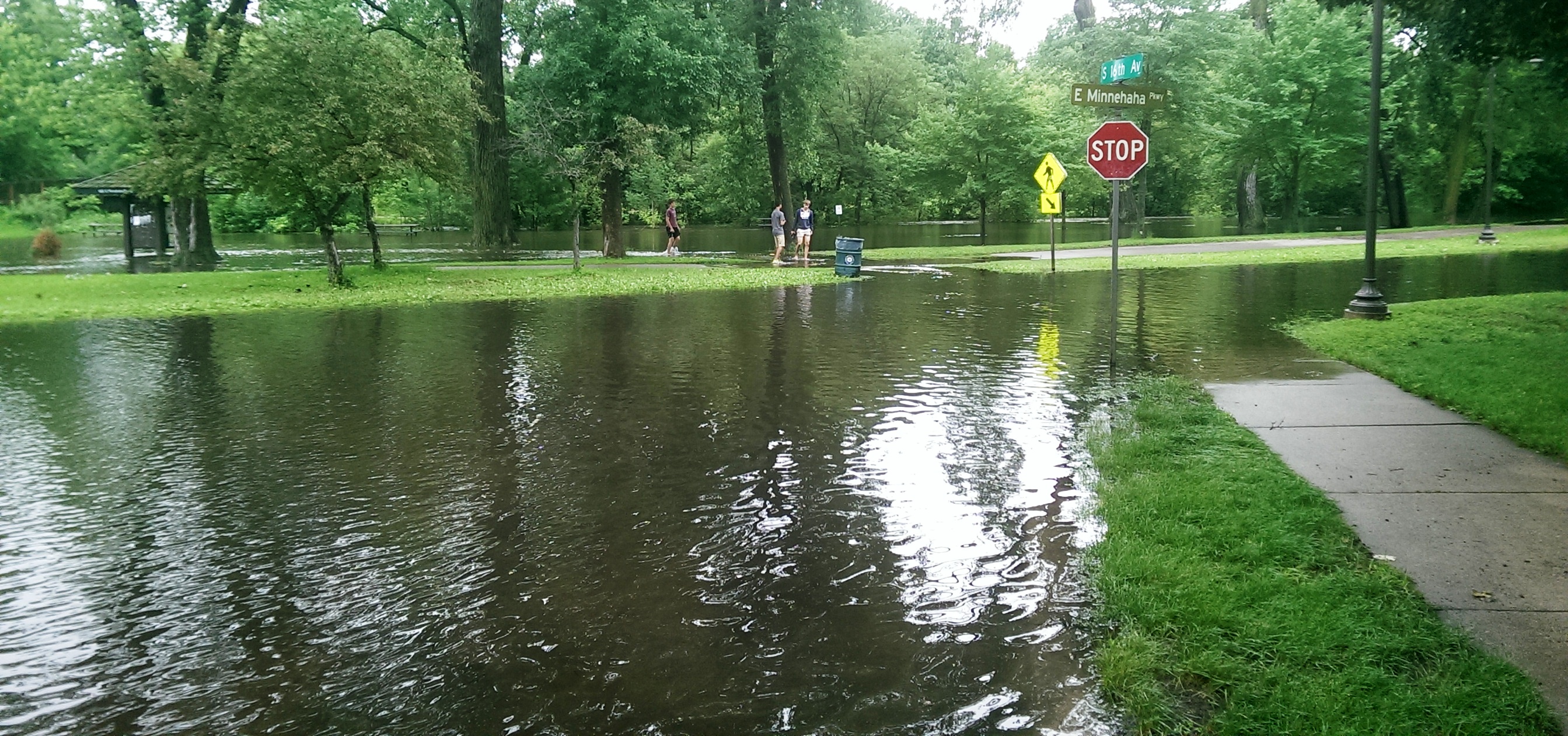
Minnehaha Parkway at 16th Avenue South. (David C. Smith)

Looking west on Minnehaha Parkway at Cedar Avenue South. (David C. Smith)
A man I met near Cedar Avenue claimed that the water reached a similar level after a 1988 thunderstorm, but the water subsided very quickly. Today it didn’t. Minnehaha Parkway was barricaded at many points east of Lake Harriet.

More than a water hazard. Hiawatha Golf Course looking south from E. 43rd Street near Standish. That is not Lake Hiawatha in the foreground. (David C. Smith)

A romantic interlude at the famous rapids of Minnehaha Creek! This is only a few yards upstream from the Hiawatha statue. (David C. Smith)
Some early descriptions of the Falls mentioned the heavy mist generated by the falls. That was true today. There was no rain falling while I was taking the pictures below, but I could feel the water in the air. Not quite as dramatic as Victoria Falls, where the cloud of mist over the falls is visible for miles — it’s called Mosi-o-Tunya, the Smoke that Thunders — but still impressive for this normally modest stream in mid-summer.
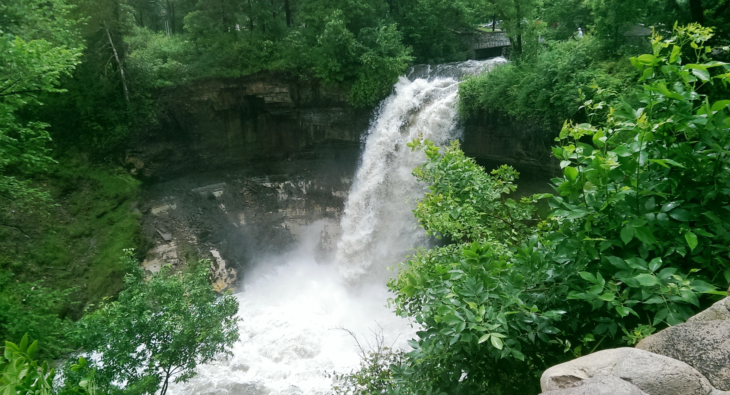
The falls made famous by Henry Wadsworth Longfellow. I recently discovered startling early plans for the park at the falls that I am waiting for permission to reveal. Stay tuned. (David C. Smith)
Unfortunately such high water levels, like the strong winds of recent years, require expensive cleanup efforts from the park board, stretching already tight park maintenance budgets. Kudos and thanks to the park board crews that will put our water-logged parks in beautiful condition yet again.
David C. Smith
© David C. Smith
Does anyone have any pictures to post of Bassett’s Creek in Theodore Wirth Park or downstream to Bryn Mawr before it dives underground? Is Shingle Creek any better?


I grew up in the neighborhood of 48th St and 13th Ave south, 2 blocks north of the creek. I remember the biggest floods being in the Spring when the ice would break up and block the creek. It would get so deep that homes across the street would have sandbags protecting them.
Thanks for that info Jack. Do you recall what years that happened?
I grew up near Minnehaha Creek on 2nd Avenue and remember some early spring floods in the late 1950s that might rival the current flood, but never this late in the spring or summer season. The Minnehaha Creek Watershed District may have data on record floods for the creek.
A great place to check. Click here for an excellent source of creek info. The site claims that Lake Minnetonka, the source of the creek, reached all-time high levels this afternoon.
David C. Smith
One wonders if the wide falls pre WPA would have handled the flow better versus the deep cut that is present now.
Excellent point, Sean. Using the pedestrian bridge above the falls to constrict water flow, ensuring some water over the falls in drier times, has to be one of the most questionable pieces of park planning ever in Minneapolis. The result has been serious erosion of the limestone cap at the falls — and we still have no water over the falls in the driest times, such as late last summer.
David C. Smith
The local news this morning declared current Minnehaha Creek water levels to be the highest in recorded history … period.
I’m not surprised. Thanks, Don.
I would trust that statement if it comes from the Minnehaha Creek Watershed District. I was at the creek near my house on Garfield Avenue yesterday and today. The lower part of the boardwalk was under water yesterday and it’s not today. I’m surprised that the creek level has dropped one to two feet already from the high point on Thursday, June 19th.
That’s good news. Thanks for the update, Tom.