Archive for the ‘Dean Parkway’ Tag
Dean Parkway History
I was asked yesterday about the history of Dean Parkway, the short parkway that connects the west side of Lake of the Isles to Bde Maka Ska from the southern shore of Kenilworth Lagoon to Lake Street. I’ve provided below a brief history of the parkway, which I originally wrote for the Minneapolis Park and Receation Board (MPRB) in 2008. MPRB’s website–minneapolisparks.org–provides histories of most parks in the system, but some of the parkway histories were dropped when the website was redesigned some time back. The Park Board’s website still provides historical information on most park properties and they continue to update my original drafts with recent developments.
I will review the historical information at the MPRB site to see if any other parkway histories could be posted here. I have already posted the original histories I wrote for East River Parkway and West River Parkway.
A historical note: the Dean Parkway history as well as others were written before the name of Lake Calhoun was changed to Bde Maka Ska. I have not gotten around to editing my old drafts to reflect that change. Someday!
Dean Parkway
Location: SW corner of Lake of the Isles to NW corner of Lake Calhoun
Size: 13.02 acres
Name: Named for Joseph Dean, an early settler in Minneapolis, whose children donated most of the land for the parkway.
Acquisition and Development
Park board records list the official date of the acquisition of Dean Parkway, which connects Lake of the Isles to Lake Calhoun, as July 6, 1892. But that date doesn’t tell the whole story.
Joseph Dean, his son, Alfred Dean, and others had offered to donate land to the park board for a lake-area parkway as early as October 1884. The original proposition was to donate land from Hennepin Avenue (which at that time was a parkway!) to Lake Calhoun—what is now Lake Street—and from Lake Calhoun to Lake of the Isles.
According to the 1892 annual report, the donation was accepted, in part, in 1887. (The annual report of 1886 already included Dean Parkway in the description of Lake of the Isles Boulevard and the 1887 annual report broke out the length of Dean Parkway—1.1 miles at the time—from the rest of the Lake of the Isles parkway.) The land connecting Calhoun and Isles and a 1200-foot strip of land along the north shore of Lake Calhoun was accepted from the Deans, but there were strings attached. The donors of the land asked that a road be opened along the entire length of the parkway by October 1, 1887. “That condition has never been complied with,” the board reported in the 1892 annual report, “because of more urgent calls for the expenditure of park funds in other directions.”
Attempts to resolve the issue were a bit messy from the start. In July 1889, Charles Loring, who had negotiated the original donation of the Dean’s land, as well as the donation of most of the shore of Lake of the Isles, perhaps a bit embarrassed that terms he had negotiated had not been complied with by the board, called the board’s attention to the matter of the delayed improvements. A month later park superintendent William Berry provided the board an estimate of the cost of building a 40-foot-wide parkway: $3,530. It was money the park board wouldn’t spend.
But there was another issue that complicated the affair: the track of the Chicago, Minneapolis and St. Paul Railroad crossed the land and a parkway would have to pass under those tracks, which had been built up over low-lying land. In late 1889, the park board began discussions with the railroad about building the drive under their track.
In 1890 and again in 1891, the heirs of Joseph Dean asked that the parkway be built as promised. The apparent patience of the Deans may have been rewarded along the way, however, by none other than Charles Loring. In November 1889, the park board had authorized Loring to negotiate with the owners of land lying between Lake Calhoun and Lake Harriet to acquire a parkway connecting those lakes. The owners of the largest piece of that land were the Deans. The park board’s instructions to Loring in those negotiations were to buy the land at the best price he could, but not to exceed $55,000 for the parcel owned by the Deans.
When Loring returned to the park board in January 1890 with an agreement to purchase the Dean’s land for what eventually became William Berry Park, he had agreed to pay them $77,000. The possibility that Loring had agreed to sweeten the deal for the Deans, perhaps as a reward for their patience over Dean Parkway, is suggested by the fact that the other parcel of land needed for William Berry Park was purchased for $36,000 from the Ueland family—exactly the “not to exceed” price specified by the board in Loring’s instructions.
The Dean’s may have received some additional compensation for their patience with the board when they sold to the board in 1891 the two blocks of land connecting east Calhoun and east Isles, which they had at one time donated. The park board had abandoned that donation, where the channel connecting the lakes was eventually built, so it could be replatted to straighten a proposed parkway there. The purchase price for that land was $22,565, payable without interest over ten years. But in a deal that was always perhaps too complicated, the Deans agreed to pay back up to half that amount through assessments on their remaining property in the vicinity.
The park board’s annual report in 1892 reported what seemed to be the happy conclusion of the acquisition of the Dean’s land connecting the lakes on the east when it reported that the “missing link” of the southwestern parkway system finally had been acquired. The report continued that the land “will certainly be of inestimable value should the discussed project of connecting these lakes by a canal be consummated.” This is the first mention in park board documents of the linking of Lake of the Isles and Lake Calhoun, which was eventually done in 1911.
The extent of Loring’s involvement in the resolution of the Dean Parkway issue was clear when, after the board and the Deans reached agreement on building the parkway in 1892, the Deans informed the board that they had executed a warranty deed for the property for the park board and left it in the possession of Charles Loring who would deliver it to the park board after a carriage drive was constructed over the property. What makes that action remarkable is that at the time Loring was no longer a park commissioner.
The railroad bridge over Dean Parkway, which had held up construction for some time, was not completed until 1896. Bridges over and under railroad tracks were a significant cost in the creation of the park system. For instance, the land for Dean Parkway was mostly donated and the initial parkway construction cost roughly $3,500, but the one railroad bridge cost more than $5,200.
Park superintendent Theodore Wirth submitted a plan in 1910 to improve the parkway and recommended in 1913 that the plan be executed, in part because the railroad had built a new concrete bridge over the parkway and the dredge working in Lake Calhoun had deposited on the northwest shore of the lake considerable fill needed for the parkway. The road work, which would cost nearly $8,000, was begun in 1914, at which time more than 55,000 cubic yards of fill were used from the Calhoun dredging. The road and walks were completed to subgrade and finished the next year.
At the time, park superintendent Theodore Wirth suggested that with the ground filled and leveled it could at some time become a playground. Wirth later referred to the improvements to Dean Parkway as an example of how swamps could be drained and how once-impassable roads could be made among the best in the park system.
In 1951 the City Engineering Department completed a new arrangement of the intersection of Dean Parkway with Lake Street, complete with traffic signals, intended to alleviate traffic problems.
Dean Parkway was not finally paved until 1972. The most recent improvements to Dean Parkway, including repaving and traffic calming measures were completed in 1996.
Trivia
The 750 feet of road from Dean Parkway to Cedar Lake over the tracks of the then Minneapolis and St. Louis Railroad did not become a part of the Grand Rounds until 1929. That year the city and the railroad paid for the park board to pave the short connecting strip and it was turned over to the park board as part of the parkway system. The connection had long been planned but never took place officially until then. Park superintendent Theodore Wirth had campaigned for the strip to be turned over to the park board as early as 1920. The park board had submitted a plan to the city planning commission in 1923 to make that connection as the park board was contemplating the acquisition of the east and north shores of Cedar Lake.
David Carpentier Smith
Restored Posts: Makwa Club, Toboggans, Building Restrictions, Parkways
Filed under: Minneapolis Parks: General | Tags: Calhoun Parkway, Dean Parkway, Harry Perry Robinson, Lake Calhoun
 Comments (4)
 In response to requests and my own whimsy I have restored several posts to these pages today.
I restored one post at the request of author Joe McAleer, whom I met through these pages. He is just finishing a biography of one of the most fascinating characters I’ve come across in Minneapolis history, Harry Perry Robinson. Joe’s book is entitled Escape Artist: The Nine Lives of Harry Perry Robinson, which is due out in June 2019 from Oxford University Press. Robinson visited Minneapolis as a young Englishman right out of college in the 1880s and made the city his home for several years while writing for local newspapers, becoming besties with many influential Minneapolitans and marrying the daughter of Thomas Lowry. He achieved his greatest fame as a correspondent covering World War I from the trenches of France for London newspapers and was knighted for his efforts. I’m really looking forward to reading his life story.
Due to a link in the piece Robinson inhabits on this site, I also restored some of my favorite photos: the toboggan slide from Queen Avenue out onto Lake Harriet. There is much to see in those images from 1914.
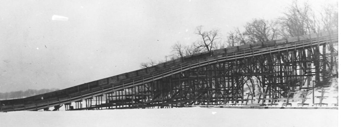
The impressive structure of the Lake Harriet toboggan slide (Minneapolis Park and Recreation Board)
Given continuing discussions of building near Minneapolis lakes, I wanted to restore a piece I wrote a few years ago about how the city passed the first ordinance limiting building heights around lakes. It was passed in 1912 in response to a threat to build a hotel beside Lake of the Isles at 25th Street.
I also reposted stories on the intersection of Dean Parkway and Calhoun Parkway.
I’ve reposted a few other pieces that seemed worthwhile, which I’ll let you discover for yourself by scrolling through the site.
David C. Smith
In the past I included my email address on everything I posted here, but due to the volume of spam I received I had to quit doing that. But you can always reach me by posting a comment on some post or page on this site. Every comment is reviewed before it is posted, so they all come to my attention.
Approaching Lake Calhoun — A Couple Years Later
Filed under: Minneapolis Parks: General | Tags: Dean Parkway, Lake Calhoun
Comments (5) Julieann Swanson, Assistant Curator of Digital Collections and Archives at the University of Minnesota’s College of Design just sent a fabulous photo of the Lake Street, Dean Parkway, and West Calhoun Parkway intersection from about 1956 in response to my post earlier today. See Julieann’s comments on that post for more information on this photo and the Digital Content Library.
Looking west on Lake Street toward the intersection with Dean Parkway and West Calhoun Parkway. (Photo: University of Minnesota, Digital Content Library)
Julieann suggested that the photo is circa 1955, but I’ve advanced it a year to 1956, because I believe that is a red 1956 Chevy sitting at the east-bound stop light. And, yes, the traffic lights are quite visible in this photo! Would that car have been called, “Cherry”? I’m a little too young to remember ’50s slang.
Thanks, Julieann.
David C. Smith
© 2013 David C. Smith
Approaching Lake Calhoun
Filed under: Minneapolis Parks: General | Tags: Dean Parkway, Lake Calhoun, William Berry Parkway
Comments (7) Two photos from the 1950s, and two that are much older, show how people got to Lake Calhoun once upon a time. Both photos are from the Minnesota Historical Society’s online collection. I haven’t written about that collection in some time, but I continue to use it extensively for research on Minneapolis parks and other historical subjects. You should take a look if you haven’t before. It’s a treasure.
The first photo shows the intersection of Lake Street, Dean Parkway and West Calhoun Parkway, looking west.
Many Minneapolis parkways were once called “boulevards”, but that changed in 1968 when the Minneapolis park board renamed nearly all of them “parkways.” The park board wanted to create uniformity in treatment, but also believed that by calling them parkways, people would better understand that they were owned by the park board and were part of the park system. I still refer to them as boulevards at times, out of habit, as do many others. Curiously, Google maps hedges, labelling the road around the west side of Lake Calhoun “W Calhoun Pkwy” and “Calhoun Blvd”.
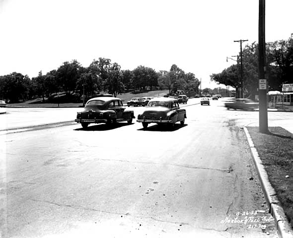
Travelling west on Lake St. at Dean Parkway. West Calhoun parkway begins at far left. (Norton and Peel, Minnesota Historical Society)
Note that the lot on the southwest corner of the intersection (upper left) is still undeveloped in 1953.
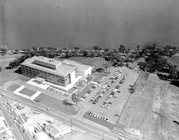
Aerial view, 1956. Excelsior Blvd. is in the foreground. Minnesota Historical Society)
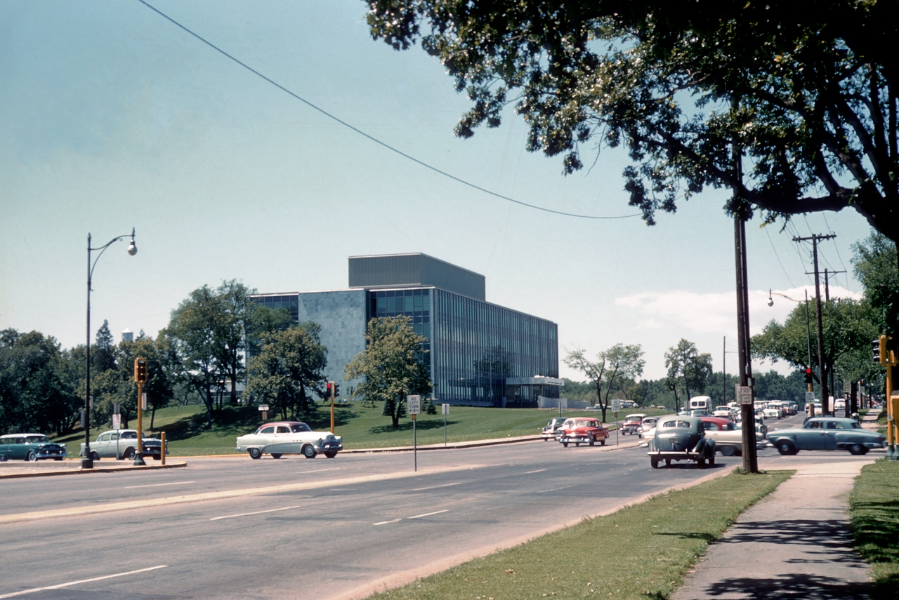
The earliest photos I’ve found of the American Hardware Mutual Insurance Company building on the site are dated 1956, such as this aerial photo from the Minneapolis Star Journal Tribune.
The park board never owned that piece of land, although it would have been a good addition to the lake park. The park board reported in 1916 that the purchase of 93 acres on that corner was pending, but the deal never was completed. The land behind the building to the southwest was once a small bay of the lake, which the park board filled with material dredged from the lake bottom.
Perhaps it’s simply an issue of the resolution of this photo, but I don’t see traffic lights even though it appears that east- and west-bound traffic is stopped. The lights must have been installed about this time, because the city engineer had developed an initial plan for lights at this increasingly busy intersection in 1951.
The photo below was taken at the opposite, or southeastern, corner of Lake Calhoun at about the same time.

36th Street approaching the southeastern corner of Lake Calhoun, 1955. Lakewood Cemetery is on the left. (Norton and Peel, Minnesota Historical Society)
The photo is notable especially because the foundation of the street railway bridge over 36th Street still stands. This was the location of the rails that went to Lake Harriet and beyond to Excelsior and Lake Minnetonka. Of course, there were no traffic lights at the intersection of 36th and East Calhoun Parkway either.

East Calhoun Parkway in about 1890. Looking north from Lakewood Cemetery.(Minnesota Historical Society)
The trestle had been there since before the park board built the parkway. (See more on the Lyndale Railway Company at Lake Calhoun and Lake Harriet.) In the photo at right you can see the bridge foundation (far right), in front of the carriage turning east onto 36th Street. The fountain in the boulevard for watering horses was an interesting touch. So was the scalloped hedge between the parkway and the lake. Does anyone know when the street railway bridge supports were torn down?
Most of the earliest parkways around lakes ran right along the water’s edge. That feature of early parkways is more prominent in the photo below of the end of Calhoun Parkway in about 1905. At that time the parkway ended where it turned south to connect to Lake Harriet. The land behind the photographer in this photo was private land all the way around the west shore of the lake back to Lake Street and the top photo.

The end of Calhoun Parkway at the south end of Lake Calhoun in 1905. The road turned to the right, the future William Berry Parkway, connecting to Lake Harriet. (Minnesota Historical Society)
The photo below shows the approach to the north end of Lake Calhoun from about the same time period as the photo above.

The north shore of Lake Calhoun from Lake Street, facing west in about 1902. (Minnesota Historical Society)
This photo shows Lake Street facing west at the northeast corner of Lake Calhoun. This was before the park board acquired the north shore of the lake. The only park land around the lake at this time was Calhoun Parkway beginning at the left of this photo and continuing to the previous photo.
David C. Smith

