Approaching Lake Calhoun
Two photos from the 1950s, and two that are much older, show how people got to Lake Calhoun once upon a time. Both photos are from the Minnesota Historical Society’s online collection. I haven’t written about that collection in some time, but I continue to use it extensively for research on Minneapolis parks and other historical subjects. You should take a look if you haven’t before. It’s a treasure.
The first photo shows the intersection of Lake Street, Dean Parkway and West Calhoun Parkway, looking west.
Many Minneapolis parkways were once called “boulevards”, but that changed in 1968 when the Minneapolis park board renamed nearly all of them “parkways.” The park board wanted to create uniformity in treatment, but also believed that by calling them parkways, people would better understand that they were owned by the park board and were part of the park system. I still refer to them as boulevards at times, out of habit, as do many others. Curiously, Google maps hedges, labelling the road around the west side of Lake Calhoun “W Calhoun Pkwy” and “Calhoun Blvd”.
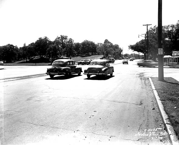
Travelling west on Lake St. at Dean Parkway. West Calhoun parkway begins at far left. (Norton and Peel, Minnesota Historical Society)
Note that the lot on the southwest corner of the intersection (upper left) is still undeveloped in 1953.
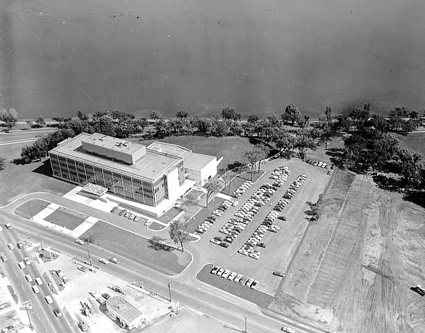
Aerial view, 1956. Excelsior Blvd. is in the foreground. Minnesota Historical Society)
The earliest photos I’ve found of the American Hardware Mutual Insurance Company building on the site are dated 1956, such as this aerial photo from the Minneapolis Star Journal Tribune.
The park board never owned that piece of land, although it would have been a good addition to the lake park. The park board reported in 1916 that the purchase of 93 acres on that corner was pending, but the deal never was completed. The land behind the building to the southwest was once a small bay of the lake, which the park board filled with material dredged from the lake bottom.
Perhaps it’s simply an issue of the resolution of this photo, but I don’t see traffic lights even though it appears that east- and west-bound traffic is stopped. The lights must have been installed about this time, because the city engineer had developed an initial plan for lights at this increasingly busy intersection in 1951.
The photo below was taken at the opposite, or southeastern, corner of Lake Calhoun at about the same time.

36th Street approaching the southeastern corner of Lake Calhoun, 1955. Lakewood Cemetery is on the left. (Norton and Peel, Minnesota Historical Society)
The photo is notable especially because the foundation of the street railway bridge over 36th Street still stands. This was the location of the rails that went to Lake Harriet and beyond to Excelsior and Lake Minnetonka. Of course, there were no traffic lights at the intersection of 36th and East Calhoun Parkway either.

East Calhoun Parkway in about 1890. Looking north from Lakewood Cemetery.(Minnesota Historical Society)
The trestle had been there since before the park board built the parkway. (See more on the Lyndale Railway Company at Lake Calhoun and Lake Harriet.) In the photo at right you can see the bridge foundation (far right), in front of the carriage turning east onto 36th Street. The fountain in the boulevard for watering horses was an interesting touch. So was the scalloped hedge between the parkway and the lake. Does anyone know when the street railway bridge supports were torn down?
Most of the earliest parkways around lakes ran right along the water’s edge. That feature of early parkways is more prominent in the photo below of the end of Calhoun Parkway in about 1905. At that time the parkway ended where it turned south to connect to Lake Harriet. The land behind the photographer in this photo was private land all the way around the west shore of the lake back to Lake Street and the top photo.

The end of Calhoun Parkway at the south end of Lake Calhoun in 1905. The road turned to the right, the future William Berry Parkway, connecting to Lake Harriet. (Minnesota Historical Society)
The photo below shows the approach to the north end of Lake Calhoun from about the same time period as the photo above.

The north shore of Lake Calhoun from Lake Street, facing west in about 1902. (Minnesota Historical Society)
This photo shows Lake Street facing west at the northeast corner of Lake Calhoun. This was before the park board acquired the north shore of the lake. The only park land around the lake at this time was Calhoun Parkway beginning at the left of this photo and continuing to the previous photo.
David C. Smith


[…] also reposted stories on the intersection of Dean Parkway and Calhoun […]
In the Park Board real estate file for Lake Calhoun I have a copy of a quit claim deed from the Minneapolis & St. Paul Suburban Railroad Company to the City in February, 1954, for the vacated former street car right of way along the east side of Lake Calhoun. At the end of the document, the railroad reserves the right to continue to operate streetcars “until discontinuance is requested” by the railroad and authorized by the City. Within 90 days of such discontinuance the bridge, ducts, electric cables, etc., are to be removed. There’s no way to tell from the document when discontinuance occurred, unfortunately.
Renay Leone
Thanks, Renay. Even if we don’t know the discontinuance date, it’s nice to have the date of the quit claim: not long before the picture in the blog post was taken. For those of you who don’t know, Renay is a real estate attorney who was hired to organize the park board’s property records, a huge task. I really appreciate Renay’s input on this blog. She’s helped answer a number of questions for me.
[…] the Lake Street, Dean Parkway, and West Calhoun Parkway intersection from about 1956 in response to my post earlier today. See Julieann’s comments on that post for more information on this photo and the Digital […]
Hi David,
Thank you for the interesting post today. Our website, The Digital Content Library (www.dcl.umn.edu) here at the University of Minnesota displays a few images of the corner of Lake Street and Dean Parkway, as described in your post. We acquired the images from the now defunct Cerny and Associates architectural firm, who designed the American Hardware Mutual Insurance Company building located on that intersection.
I am happy to email you a color copy of one of the images to be shared on this blog. Our copy is from the same vantage point as yours, only in color, ca. 1955. Note that there are traffic lights in our ca. 1955 image.
You and your readers may also search the collection, however the images are only viewable as a thumbnail size for viewers outside of the University of Minnesota community, since it is a teaching and learning site.
All the Best-
Julieann Swanson
Assistant Curator
Digital Collections and Archives
University of Minnesota
Thanks, Julieann, you curate a marvelous asset. I would encourage everyone to visit your site. Another treasure.
I’d love to post the image you descibed of that intersection. You can email it to me at minneapolisparkhistory[at]q.com.
If anyone were interested in viewing or acquiring images from your library, but are not students or teachers at the U of M, would it be possible? If so, what would someone need to do?
Thanks again.
Thanks David, yes, viewers outside of the University of Minnesota community may view the website at http://www.dcl.umn.edu. Thumbnail size images are viewable for the general public, however, our copyright agreement does not allow us to grant access to anything larger than thumbnail size for non-educators or non-students. We will sometimes allow special permission in special circumstances. Thank you for your kind words about our collection, and helping to promote our site. We are big fans of your blog.
Best Regards,
Julieann