Archive for the ‘Prospect Park’ Tag
Norma Olson Remembers Prospect Park Triangles
Filed under: Minneapolis parks | Tags: Maris Thomes, Norma Olson, Pratt School, Prospect Park, Tower Hill
 Comments (5)
 In Devon, England last week a former resident of Minneapolis found this website and was intrigued by my account a few years ago of the smallest parks in Minneapolis, the triangles in Prospect Park, near Tower Hill. Becky Stannard, my correspondent, remembered them well, having attended Pratt School. But she had more than memories, she had a story about how the boulders appeared on the triangles there. It was written by her mother, Norma Olson. I have printed it below, with thanks to Becky and Norma.
Maris’s Mini Parks
By Norma Olson, 2-28-94
In Prospect Park
Where we lived for 40 years
Scattered through the neighborhood
At the intersections of streets
Are small triangles and squares of land
Left over from the making of streets
Whose design was influenced
By the old cow paths
Dating back to farming days.
When Lady Bird declared
With enthusiasm, if not passion
That Beauty was important
That wherever possible, in America
We plant a shrub or tree
We took it to heart.
The local Beauty Committee
Especially Maris Thomes
Who has lived some in Japan
Started talking about the opportunity
Offered by our bits and pieces — the triangles.
She cocked her head and mused
Wouldn’t it be nice
If we had some big rocks
To help us dress up those triangles?
For some months, after finding myself
President of the Minneapolis Committee on Urban Environment
An organization with big ideas, little power and no budget
I had been visiting around City Hall
With the pros at the Park Board, the Housing Authority and Public Works
It’s sort of a treat for middle management bureaucrats
To dream a little and to visit with neighborhood people
Who aren’t asking for anything.
While I knew most of these folks from other contexts
They might have eyed me with
A certain amusement
But a condition of trust existed.
On this day, in late winter I dropped in on Martin,
Associate Operations Engineer
At Public Works, during his coffee break.
“Well, come in and sit a spell. What are you up to today, Norma?”
“Nothing much.”
“Don’t tell me you don’t have a project up your sleeve.”
“Well, there is Maris’ dream.”
“Heavens, what’s that?”
“Well, you know all those triangles in our neighborhood
That you folks long ago left behind
When you designed the streets.
They look bad but they could be a visual asset.”
“How so?”
“We have in mind that we’d like to do
Something with them.
Like clean them up, do some planting.
Maris says we need some big rocks
To add a sculptural quality.
Remember, Martin, you asked me and I thank you.
So thanks for listening.
But as you can see, I’m not setting
The world on fire.”
One evening in early fall, the phone rang at 10 P.M.
“Hello, Norma, this is your friend
Martin from Public Works.
You know, we are excavating
For those huge storm sewers all over S.E.
And you can’t believe the big rocks we are encountering
I mean two or three tons.
Could you use some?
“Oh, yes!”
“How many”
“Twenty-seven. Three for each of the nine street triangles
We talked about earlier.
But we’ve got no trucks, no transport, no manpower, no budget.”
“Well, no problem,” says Martin.
“If you will wait until the ground freezes
So we don’t break the curbs driving over them
And if you will let me know
Exactly where you want them
I will deliver them to you in the evening
And give you warning when they are coming.”
Agreed.
Maris responded to this offer with wild enthusiasm.
And with three weeks of lead-time!
Preparing plans would be easy. Agreed.
Being an artist, it was not difficult for her to take
Measurements of the nine sites.
And in consultation with resident architects
She mapped each triangle xxxing in the rock locations
Respecting that some would be more round or oblong
Than others.
Then came the phone call.
Meet Martin at the Franklin Hill triangle at 8 P.M. tomorrow night.
Before midnight, under Maris’ directions
All 27 rocks were in place
In dynamic groupings of three.
In the morning, neighbors looked out on a new landscape.
Well, not everyone was enchanted.
Bill called to say, “Do you know that one neighbor is hopping mad
To find those big rocks on her triangle.”
But the unfriendly soil was worked
Tulips bought with memorial money were planted
A few shrubs went in
And we sat back to wait for spring.
Propriety residents from the immediate rock locations
Joined the work crews
And soon the neighborhood had a new visual identity
The triangles had become a unifying factor in the
Neighborhood design.
Then came the day
When the street repaving crews showed ready and raring to tear up
Existing curbs and streets. Panics. The phone rang off the hook.
We went immediately to see
Perry, the chief of Public Works and told him our story
And insisted that the triangles had to be respected as follows:
Leave the rocks in place or replace them precisely if the have to be moved.
Let the new landscape designs for the neighborhood include the triangles.
Assign a budget number for new materials
As compensation for time and plant materials expended.
These requests were in written form
We were accompanied on this mission by the
Administrative Assistant of our Alderman.
Perry was impressed that the requests were reasonable
Agreement was reached. The neighborhood was reassured.
And so the newly curbed triangles, after consulting, were
Expertly planted with many new evergreens as a base
Were ready for spring materials.
And so they have become a vital part of
The Neighborhood landscape
With adjacent owners feeling possessive
Looking after maintenance.
Mandy managed her triangles.
Kate planted a tree for John Berryman
The Franklin Avenue Bridgehead Planting included a Ginkgo Tree.
It was a project of enormous satisfaction to me
Because it cost so little, brought staff and citizens
Into an effective working relationship
And strengthened the neighborhood
With another point of pride. It was fun making it happen.
Thanks also to Maris Thomes, Martin, Perry, Bill, Kate, Mandy and everyone else who took part in this successful collaboration.
While on the subject of Prospect Park and Tower Hill, I have a question. Does anyone know the inside story on what happened to plans to vacate Malcolm Ave. S.E. between Pratt School and Tower Hill Park? I recently came across park board resolutions and drawings of plans to vacate the street and turn it into a playground for the school. The original plans were dated 1928, but the issue was raised again in 1950 in response to petitions from the neighborhood and another resolution was approved to complete those plans. The park board announced in the 1950 annual report that the vacation of Malcolm Ave. had added 0.17 acres to Tower Hill Park. But Malcolm Ave. still runs between the school and park. Was it closed, then reopened? I’m sure someone knows the story. Please share.
David C. Smith
Prospect Park Memories
Filed under: Minneapolis Park Memory | Tags: Luxton Park, Prospect Park, Tower Hill Park
Leave a comment Joan Pudvan’s comment on the previous post reminded me to share a wonderful image of Tower Hill that she sent to me.

Tower Hill, by Opal Raines, in about 1944. This is the cover illustration of Memories of Prospect Park, edited by Joan Pudvan. (Image courtesy of Joan Pudvan)
For more memories of a neighborhood, Prospect Park in southeast Minneapolis, and two parks, Tower Hill and Luxton, I’d encourage you to have a look at the book Joan put together, Memories of Prospect Park, in 2001. The book is a compilation of memories from many people covering the years 1910-1950. The book is available at the Minneapolis Central branch of the Hennepin County Library and the Minnesota Historical Society Library in St. Paul.
David C. Smith
I Finally Made It!
Filed under: Minneapolis Parks: General, Tower Hill Park | Tags: Prospect Park, Tower Hill, Witch's Hat
Comments (6) I finally climbed the Witch’s Hat Tower in Tower Hill Park. The erstwhile water tower was completed in 1914 after the park was acquired by the Minneapolis Board of Park Commissioners. I have already written about the tower here and here and here. Today I’m just providing proof of my climb with photos and a few brief observations.
Most years the tower is only open one night a year, the night that Pratt School has its ice cream social, which was last Friday, but this year the tower will also be opened to celebrate the dedication of the tower 100 years ago. That will take place July 12 and 13. So you get an extra chance to see the view from the top this summer.

The view west toward downtown — and into the sun. Pratt School is at the bottom. I took the picture a little after 5 p.m. I didn’t have to wait in line to make the climb, but by the time I descended about 100 people were in line waiting their turn. (David C. Smith)
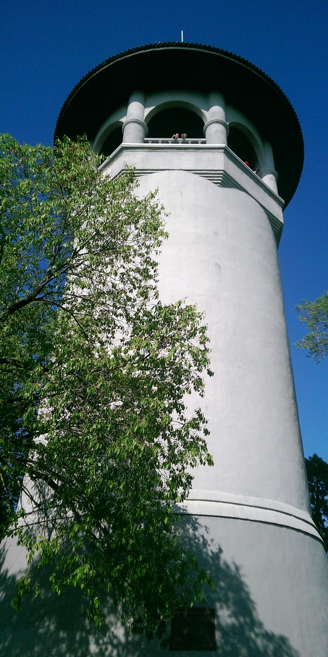
The Witch’s Hat from the terrace near the entrance to the tower. It was a perfect day for a view. It really is this white and sky really was this blue. My Dad, who turns 90 this year, chose not to climb the 100+ steps to the top of the tower, but still enjoyed the spectacular view from the terrace. Even if you miss the few chances to climb the tower, visit the park for beautiful views of the city. (David C. Smith)

The view from the Witch’s Hat to the southwest, across Prospect Park and the Mississippi River into South Minneapolis. This was my favorite view, in part, because of how well the Mississippi River is hidden. You can tell it’s there and you can see part of the railroad bridge over the river, but it is amazing how such a prominent and predominant geographical feature can be swallowed by the landscape. I couldn’t help but imagine the wildness of the view from here 150 years ago — before buildings and also before the Minneapolis park board planted hundreds of thousands of trees along city streets. Early writers note that what is now South Minneapolis, from the river gorge to the lakes in the southwestern part of the city, was mostly treeless prairie. The Tower Hill Park tennis courts are visible in the lower right corner. (David C. Smith)

The top of the stairs down the Witch’s Hat. (David C. Smith)

The spiral staircase of the Witch’s Hat. It was narrow enough that I had press up against the wall and suck in my (shrinking) stomach to pass people going the other way. The large deck at the top of the tower was intended to be a bandstand for concerts, but musicians had a difficult time getting their instruments up this narrow staircase. Imagine lugging a bass, bass drum or tuba up or down. But others were once able to enjoy the view any time. When the tower was first opened in 1914, the park board paid a park keeper to open the tower to the public five days a week. (David C. Smith)
If you took better photos than I did, please email them and I’ll post them here.
David C. Smith
© 2014 David C. Smith
Witch’s Hat Centennial at Tower Hill
Filed under: Tower Hill Park | Tags: Frederick W. Cappelen, Prospect Park, Tower Hill Park, Witch's Hat
Comments (3) 
The above image, a poster from the 60-year anniversary of the construction of the Witch’s Hat on Tower Hill, was sent to me by a reader in the Netherlands. The top is apparently from Frederick W. Cappelen’s original design for the tower in 1913. The bottom is a groovy, so ’70s, panorama of Tower Hill.
My correspondent from the Netherlands, who spent part of his youth in Prospect Park, wanted to know if a poster had been created for the centennial of the tower.
I’m happy to report that plans are in the works for a poster and a t-shirt featuring the tower. Joe Ring informs me that because the official dedication of the tower didn’t take place until the summer of 1914, even though construction began in 1913, the neighborhood is holding the centennial this year instead of last year.
So it looks like we may have two opportunities to climb the tower this summer and see what has to be the grandest panorama available in these parts.
Pratt School, across the street from the park, is having its annual ice cream social May 30, 5-8 p.m.. That is typically the only day of the year when the tower is opened to the public. So enjoy some ice cream, listen to some music and climb the tower that night.
But Joe informs me that the tower will be open for its centennial celebration on July 12 and 13, as well, with another concert planned for July 15. Definitely more dates to put on your summer calendar.
David C. Smith
© 2014 David C. Smith
Triangle Followup: Prospect Park, Laurel and Sibley Triangles
Filed under: Minneapolis Parks: General, Prospect Park, Sibley Field | Tags: Laurel Triangle, Prospect Park, Sibley Field, Sibley Triangle
Comments (3) Summer gardens are gone and I never got a good picture of another beautiful park triangle: Sibley Triangle located in northeast Minneapolis where Washington Street NE and Fifth Street NE meet. (For earlier posts on park triangles see this one on small triangles and this one on triangles in Prospect Park.) Every time I was in the neighborhood I was without camera, so if any readers have photos I’d like to post them. The garden is planted and maintained by volunteer Robin Russell, who has done a fantastic job. Sibley Triangle is another of Minneapolis’s six triangles that are listed as 0.01 acre. The park board acquired the little triangle from the city in 1920.
Like Sibley Field in south Minneapolis, it was named for Henry Hastings Sibley, but the triangle was named first. Apparently having a little street triangle named for Sibley did not sufficiently honor Minnesota’s first governor, so the larger neighborhood park was named for him too — three years later. (The larger park had previously been referred to as Cedar Avenue Heights Park. See more here.)
I was also informed by Michelle Kellogg of the park board that the volunteer who deserves the credit for maintaining the tranquil gem of Laurel Triangle in Bryn Mawr is Patty Wycoff. Thanks Patty!

Laurel Triangle 2011
Finally, I spent an enjoyable evening in July with the Prospect Park Garden Club at the home of Mary Alice Kopf talking about triangles and other parks in the neighborhood. Thanks to Julie Wallace who dug up the info from neighborhood association documents that Bedford Triangle and Clarence Triangle were altered in 1979. Bedford Triangle was obliterated and the street on one side of Clarence Triangle was removed so it now appears to be part of the yard on the northwest corner of the Bedford and Clarence intersection. The only thing that suggests it is not private property is a boulder on the corner — as in the other Prospect Park triangle parks. I learned that night that the boulders were unearthed during the construction of I-94 through the neighborhood.
David C. Smith
Prospect Park Garden Club wins Triangle Award; Orlin Triangle is smallest park.
Filed under: Bryn Mawr, Minneapolis parks, Prospect Park | Tags: Bryn Mawr, Elmwood Triangle, Laurel Triangle, Orlin Triangle, Prospect Park, Rollins Triangle
Comments (1) An update on the smallest park triangles:
The beautiful triangles in Prospect Park are maintained by the Prospect Park Garden Club. I learned that in the delightful backyard of Mary Alice Kopf last Saturday during the Annual Garden Walk and Plant Sale sponsored by the Prospect Park Garden Club. Nobody I talked to in Prospect Park knew, however, why some triangles were taken over by the park board and others weren’t. So if you know…
I am certain now that Orlin Triangle is the smallest of the street triangles in the Minneapolis park system.

Orlin Triangle in Prospect Park is the smallest park in Minneapolis.
The second smallest is Elmwood Triangle at Luverne and Elmwood just north of Minnehaha Creek near Nicollet. Basic grass and tree — and two dead end signs. Seems a bit ominous.

Elmwood Triangle, the second smallest park in Minneapolis, listed at 0.01 acre. Based on my rough measurements, bigger than Orlin Triangle.
The most attractive triangle park outside of Prospect Park is Laurel Triangle in Bryn Mawr. My next task is to find out who takes care of this park. Laurel Triangle was purchased by the park board for $700, most of which went to pay back taxes, in 1911, so it’s a little older park officially than the Prospect Park triangles.

Laurel Triangle, at Laurel and Cedar Lake Road, is beautiful too, in a wilder way than the Prospect Park triangles. So big it has two sidewalks and two stop signs. There’s a little stone bench next to the tree that I’d love to sit on with a cup of coffee.
Another of the smallest triangles is Rollins Triangle at Minnehaha and E. 33rd St. across from Peace Coffee. Quite a different environment on a busy thoroughfare and considerably larger than the smallest. Farther south, Adams Triangle on Minnehaha and 42nd, is one-third-acre, one of the larger triangles.

Rollins Triangle has a newspaper stand, a bus bench, vent pipes and a bit of a garden that’s overgrown. Definitely larger.
Most triangles are named for streets, but Rollins was named for the real estate development, Rollins Addition, in the neighborhood. It was taken over by the park board at the request of the city council in 1929 and officially named in 1931.
Someday soon I’ll visit the two remaining triangles listed at 0.01 acre in the park board’s inventory, Sibley and Oak Crest in northeast Minneapolis. But judging by their images on Google maps they are both larger than triangles shown here.
I purchased several plants for my yard at the Prospect Park Garden Sale at Pratt School. This whole business of planting triangles inspired me. And that was one objective of early park planners — to encourage us to replicate the pretty little public gardens on our own property.
David C. Smith
Did You Know? Tower Hill is not named for the “Witch’s Hat” tower.
Filed under: Minneapolis Parks: General | Tags: Prospect Park, Tower Hill Park, Witch's Hat
Comments (5) The park was named “Tower Hill” in 1909 four years before the water tower with the tall roof was built.
After purchasing the land for the park in 1906, the park board named the park “St. Anthony Heights.” Residents of the area petitioned the board to change the name to “Tower Hill,” which it did finally in 1909. The name was based on a long-gone observation tower built on the hill by an entrepreneur: for a dime anyone could climb the tower.
In the annual report for 1908 park superintendent Theodore Wirth presented his plan for improving the park, which included a suggestion to build an observation tower on what he called the “small plateau” at the center of the park. He continued: “This tower should be built of stone or steel and ought to be from 50 to 60 ft. high.” The park board never built that tower, but gave permission to the Minneapolis water department to build a water tower in the park in 1913 — the Witch’s Hat tower that still stands.

The Witch’s Hat photographed beautifully from Stadium Village by April M. King, aka Marumari. Pratt School is in the foreground.
The expansive viewing area at the top of the tower certainly fulfilled Wirth’s desire for an observation tower, although park board records do not indicate that it was a condition for granting permission to build the water tower in a park. In 1914 the city council asked the park board to provide a caretaker for the park, so people could climb the tower. The park board complied, providing a caretaker who opened the tower to the public five days a week.
As with so many park programs over the years it is easier to pinpoint when a service or program began than when it ended. There is no indication in park board records of when it stopped providing a caretaker to open the tower to the public.
David C. Smith
Lost Minneapolis Parks: A Fifth Prospect Park Triangle
Filed under: Lost Minneapolis Parks, Minneapolis parks | Tags: Midway Triangle, Prospect Park, Tower Hill Park, Witch's Hat
Comments (1) A fifth Prospect Park triangle was added to Minneapolis parks inventory in 1919 when the City Council turned over a 0.03-acre triangle at the intersection of Bedford Street and University Avenue S.E. The Minneapolis Board of Park Commissioners (BPC) instructed the superintendent to plant shrubbery on the triangle and to maintain it. It was named Midway Triangle. The City Council must have forgotten that it gave the land to the BPC—or ignored the fact—because in November 1944 the BPC adopted a resolution that “inasmuch as the intersection of University Avenue and Bedford Street, including what was formerly Midway Triangle, has been paved,” it was turning over the land to the City Council. There is still a remnant of the triangle at the intersection, just enough curbed space to hold a traffic signal, a light post and some signs.
The entire neighborhood might have looked quite different if the Minneapolis park board had acted on John Pillsbury’s proposal in 1887. Pillsbury was the former Governor of Minnesota and former Minneapolis park commissioner and still the president of the University of Minnesota’s Board of Regents at the time, who had just donated a $150,000 building to the University. He proposed that University Avenue be made a parkway from Central Ave. to the county line (the boundary with St Paul) and that from Oak Street east the parkway be 120 feet wide, or more than 50% wider than it is now.
That might have been spectacular, but it is also possible that a parkway on University Avenue would have suffered the same fate as early parkways on Hennepin Avenue from Loring Park to Lakewood Cemetery and Lyndale Avenue North from Loring Park to Farview Park. They were eventually abandoned by the BPC as parkways and returned to the control of the City of Minneapolis, because they carried too much traffic to be true parkways. I suspect the same would have happened to a parkway on University Avenue; it was a major thoroughfare. But it’s fun to speculate and try to picture a beautiful wide boulevard approaching the University of Minnesota from the east—in the shadow of Tower Hill.
David C. Smith
The Award for Prettiest Triangles Goes to….Prospect Park!
Filed under: Minneapolis Parks: General | Tags: Bryn Mawr, Prospect Park, Tower Hill Park, Witch's Hat
Comments (5) The prettiest little parks in Minneapolis are in Prospect Park.
I visited that neighborhood recently — it’s not a place you pass through conveniently on your way to anywhere else — to see what kind of damage the Emerald Ash Borer had done to Tower Hill Park.

The view from Tower Hill. One of three “overlook” views of the city from parks that you should check out. The others are Deming Heights Park and Theodore Wirth Park. (All photos: Talia Smith)
Last year nearly 80 diseased ash trees were removed from the park in which the green beetle had staked its first claim in Minneapolis. I anticipated seeing the Witch’s Hat on a bald head. Not so. Other species, especially the old oaks, make the absence of ashes barely noticeable. Several new trees had been planted, but the vegetation around the hill and tower is very dense. Given the weather of the last few months, the park, as well as the rest of the neighborhood, had the feel of a rain forest. The gentle mist at the time exaggerated the effect.
While in the neighborhood I wanted a closer look at the street triangles that are owned as parks by the MPRB. My recollection from visiting them a few years ago was that they were among the smallest “parks” in the city and the MPRB inventory lists Orlin Triangle (SE Orlin at SE Melbourne) as one of six triangles that measure 0.01 acres. The other one-hundredth-acre parks are Elmwood, Laurel, Oak Crest, Rollins and Sibley, all triangles; however, all but Elmwood appear to the naked eye to be considerably larger than Orlin.
Orlin Triangle measures roughly 30 feet per side. What’s remarkable about the triangle though is that it is a little garden. The unifying element of the little triangle gardens in Prospect Park is that each has one, two or three boulders.

Orlin Triangle, the littlest and one of the prettiest parks.
The first record I can find of requests to have the park board take over Prospect Park street triangles was in 1908. In response to a petition from the Prospect Park Improvement Association, the park board agreed on September 7, 1908 to plant flowers and shrubbery on the triangles and care for them if the neighborhood would curb them and fill them with “good black soil,” and “obtain the consent of the City Council to the establishment of such triangles.” The triangles were apparently at that time just wide and probably muddy spots in the roads.
The association reported in November of that year that the triangles were ready for planting. There is no indication in park records of how many triangles were involved or exactly where they were. Nor is there any record of whether the park board planted the flowers and shrubs as promised, or cared for them.
The next time I can find those properties mentioned in park board proceedings is 1915 when the City Council officially asked the Board of Park Commissioners to take control of four triangles in Prospect Park, which the park board agreed to do in October, 1915. In November the board named the four after the streets on which they were located: Barton, Bedford, Clarence and Orlin. Bedford was at some point paved over and no longer exists.

The mystery triangle at Clarence and Seymour. Love the maple tree. That’s Tower Hill Park in the background.
As for Clarence Triangle, its official address is listed in the middle of a block of houses and there is no traffic triangle at the corner of Bedford and Clarence where it is supposed to be. There is a triangle, however, at Clarence and Seymour, which is considerably smaller than the 0.02 acre that Clarence Triangle is listed at. If this were a park triangle it would easily be the smallest in the park system, measuring only 20 feet per side.
Somebody must mow the grass around the little maple tree. Did MPRB plant the maple tree or did someone else? Was it the same someone elses who maintain the other triangles in Prospect Park?
The other impressive non-park triangle in Prospect Park is at Orlin and Arthur. This is a three-boulder triangle blooming with gorgeous flowers. I’m sure the rest of the park system would be honored if this, too, were an official triangle park.
These little gems of gardens are what the park founders had in mind for the park system. They didn’t imagine giant sports complexes or ball fields in parks. They imagined parks to be little places of beauty — civilizing natural beauty — which is why they agreed to make parks of small odd lots at street intersections anyway. When you see the triangle parks of Prospect Park, you will understand better the intentions of the founders of Minneapolis parks.
Somebody deserves an award for maintaining those beautiful triangles, I just don’t know who to give it to. If you do, let me know.
The runner-up for prettiest triangle is Laurel Triangle at the intersection of Laurel Ave. and Cedar Lake Road in Bryn Mawr. Whoever planted and tends that garden deserves praise too.
David C. Smith

