Archive for the ‘Theodore Wirth’ Tag
See You at the Superintendent’s House
Filed under: Minneapolis parks | Tags: Lyndale Farmstead, Theodore Wirth, Theodore Wirth House
 Leave a comment
 A last-minute notice: Stop by the Superintendent’s House, often called the Wirth House, in Lyndale Farmstead Park today, May 17, and say hello. Park Superintendent Al Bangoura has once again opened the historic house where he lives (he pays rent!) to the public as a part of the Doors Open weekend. The historic home was built by the Minneapolis Board of Park Commissioners as a home and office for Superintendent Theodore Wirth in 1910.
I’ll be there along with Al and others who are knowledgeable about the house history, including some former residents. We’ll be there today only — no Sunday opening this year — from 10 am to 5 pm.
If you still don’t have your copy of City of Parks, or you need one for a gift, you can buy one there and I’ll sign it for you. All proceeds to the park board.
David Carpentier Smith
Open Door at the Superintendent’s House
Filed under: Minneapolis Parks: General | Tags: Lyndale Farmstead, Theodore Wirth
Leave a comment Today and tomorrow, May 13 and 14, the Minneapolis Park Superintendent’s House in Lyndale Farmstead Park will be open to the public from 10 a.m. to 5 p.m. It’s a rare opportunity to see the interior of the home–and office–built for acclaimed Park Superintendent Theodore Wirth in 1910. The house is currently the home of Park Superintendent Al Bangoura and family. They have kindly agreed to open their historic residence to the public this weekend.
I will be at the house to talk about parks, Theodore Wirth, and the house. I hope you will drop by and say hello. We will even have copies of City of Parks for sale. I would be glad to autograph a copy for you–and maybe one for your Mother for a special Mother’s Day gift. No formal presentations are planned, but we’d be happy to try to answer your questions about the house and park. This will be a great chance for you to meet Al Bangoura and his wife, Kendra Lewis, too. We will also be joined part of the weekend by Dana Wirth Sparks, great granddaughter of Theodore Wirth, and by Mark Ruhe, who lived in the house when his father, Robert Ruhe, was park superintendent in the 1960s and ’70s.
I’ve written about the house and some of the controversy surrounding its construction here. You can read much more about the park and house by clicking on the “History” tab on the Lyndale Farmstead Park page at Minneapolisparks.org.
I hope to see you there. I’ll be on the lower level of the house in what was once a drafting room and Theodore Wirth’s office. A word of caution: the staircase to the lower level is steep and there is no elevator.
David C. Smith
H.W.S. Cleveland: Old New Posts
Filed under: Minneapolis parks | Tags: Bde Maka Ska, Frederick Law Olmsted, H.W.S. Cleveland, Lake Calhoun, Lake Harriet, Theodore Wirth
Leave a comment A few years ago I deleted several posts on this site about Horace William Shaler Cleveland because I intended to use that information in a biography of Cleveland. I have since been distracted from that project and while I still plan to pick it up again, I thought it useful to re-post some of that information about a man who contributed so much to Minneapolis’s quality of life. So for the next few days I will post some of those hidden historical nuggets about Cleveland and his work in Minneapolis parks. I think much of the information I have discovered about Cleveland’s interactions with Frederick Law Olmsted may also be of interest due to the extensive coverage of Olmsted’s work in the past year.
The first “re-post” is from 2010 when I wrote about the history of plans to connect Lake Calhoun to Lake Harriet by a canal. (When I wrote these pieces about Lake Calhoun that was still it’s legal name. It has since been changed to Bde Maka Ska, but I have not edited those articles to reflect the new name.)
Connecting Lake Harriet and Lake Calhoun
David C. Smith
Lake Hiawatha Water Management
Filed under: Minneapolis Park Board, Minneapolis parks | Tags: Hiawatha Golf Course, Lake Hiawatha, Minnehaha Creek, Theodore Wirth
Comments (3) The Minneapolis Park and Recreation Board (MPRB) recently published background documents on water management issues at Lake Hiawatha and Hiawatha Golf Course that have guided priority-setting and decison-making for the past two years. I would encourage everyone with an interest in the subject to have a look at the papers in the “What’s New” tab at the bottom of the linked page. For many of those most involved in the issue, this review of the project may be redundant, but for many others it will establish a useful starting point for discussion. Even for experts, these documents may provide a good review of the analysis and evaluations upon which park board staff have relied.
What I have not found in those otherwise useful briefings was a recap of historical events to put water levels in perspective. So….here goes. Let’s turn the clock back again. (For more background on the creation of Lake Hiawatha and the adjacent Hiawatha Golf Course and some cool “before” photos, read my recent post Troublesome Lake Hiawatha.)
Lake Depth
Theodore Wirth’s initial plan for dredging Lake Hiawatha was to dredge to a depth of 14 feet. Due to budget concerns, however, he had reduced his dredging plan to a depth of ten feet when contracts were let. In his 1929 annual report (dated January 1, 1930), he wrote that ten feet “as called for in the present contract is the very minimum depth a lake should be, and the only reason for specifying such a minimum depth was to keep the cost…down.” He added, however, that due to money saved through a very competitive bidding process, “it is my earnest recommendation that it be increased to fourteen feet.” His argument was twofold: one, it would produce a “cleaner” sheet of water with less vegetation; two, it would bring the land area to a “higher and more desirable grade at a reasonable cost of $35,000.” That additional four feet of dredging, he noted the next year, had produced an additional 270,000 cubic yards of material.
By the time grading of the new golf course was done, Wirth wrote in his 1932 report that a low lake level and favorable weather had “permitted the creation of much more undulation than hoped for in the great area of level land devoted to the golf course…with the happy result that the eighteen holes will be a more interesting course than it was anticipated could be made.” Had more extensive grading also produced more low areas that could eventually flood?
Lake Level
The lake level used as the average in the contemporary water management study reached via the link at the top of this post is 812.8 ft MSL or above mean sea level. The measurement of levels has changed a few times in the last century. The water levels cited in park board reports from its beginning in 1883 through the time Lake Hiawatha was dredged were in feet above “city datum.” Never mind what that means for a moment. In his 1931 annual report Wirth gives a “normal” elevation of Lake Hiawatha as 100 city datum. To translate city datum measures to contemporary MSL measures requires the addition of roughly 710 ft to the city datum. (If a geodesist finds that I’m off, please let me know a better translation.)
Yikes! That means today’s “normal” of 812.8 ft. MSL is nearly three feet above normal in Wirth’s time of about 810 ft MSL. Take three feet of water off Lake Hiawatha today and most of the golf course and all surrounding neighborhood basements are dry.
But wait, there’s more!
Although 100 was considered the normal level for Lake Hiawatha in 1931 the actual water level that year—the year dredging was finished in a very dry year—was only 96.25! In today’s terms that would be about 806.25 ft MSL, or six-and-a-half feet, roughly one Kawhi Leonard, below today’s normal!
Wirth provided this data in a section of his 1932 report that explained how the park board had contracted with the city to pump city water into the lakes to raise levels. In 1931 the park board paid the city $1,422.25 to pump 113,780,090 gallons of city water into Lake Hiawatha to raise its level to 98.62 ft or roughly 208.62 ft MSL, still four feet below today’s normal! The same year the park board paid the city $3,071.09 to pump 245,687,400 gallons into the Chain of Lakes (Cedar, Isles and Calhoun) and $1,201.19 to pump 96,095,580 gallons into Nokomis.
Why did they do it? Wirth’s words:
“As an experiment to find out definitely how practical and at what cost it would be feasible to raise our lake levels during dry periods, and in order to have the appearance of our lakes in presentable condition for the Knights Templar Conclave in June, together with a desire to have the bathing beaches at certain lakes made available for use…It will be difficult to operate our Lake Calhoun and Lake Nokomis bath houses efficiently with the present elevation of water.”
While noting that given the board’s finances it would be difficult to find the funds to pump water into the lakes in 1933, the Great Depression was grinding people and landscapes to dust, Wirth estimated it would cost $21,762.50 to pump the 1.741 billion gallons of water needed to raise the lakes to normal elevations. (Precision was one of Wirth’s strong suits—as was his compulsion to make his parks “presentable”.) That money was not forthcoming from the park board’s budget, and that year the situation was the “worst in memory,” Wirth wrote. But water was pumped thanks to the city council which had “come to the rescue”.
Not the End
That beneficence was not, of course, the end of water level problems in Minneapolis lakes. By the mid-1950s the situation was so bad that a pipeline was built from Bassett’s Creek to Brownie Lake to pump water into the lakes and ultimately Minnehaha Creek. Unlike Minnehaha Creek, Bassett’s Creek seldom went completely dry. Even that wasn’t a long-term solution. The park board considered a famous hydrologist’s recommendation in the 1960s to capture water from the air conditioners of downtown office buildings to recycle through the lakes. But the owners of those buildings knew a good idea when they heard one and began recycling their air conditioning water back through their own plants. So the park board eventually built a pipeline from the Mississippi River to the lakes, but that failed too when high phosphate levels in river water threatened lake health. So as you can see, through most of park board history the big challenge was how to raise lake levels, not lower them.
Despite the park board’s ownership of the land fronting on lakes and creeks—one of the marvels of the city—we should keep in mind that the park board cannot manage water tables. Has the park board altered shore lines and creek beds? Absolutely. And anytime that is done there can be unintended consequences that can play out over many years. (“Don’t mess with Mother Nature,” some would say! I am presently writing about one of those decisions that still could have very sad consequences.) But water tables, precipitation and run-off (climate change!) are not within the park board’s control—even when, as at present, park commissioners envision a role for the park board in issues outside the purview of historical park and recreation management. And although I am not a hydrologist, it does not seem logical to me that past park board water-shaping efforts—short of building dams, which they did not do except at Longfellow Lakelet and Shingle Creek—could have been the cause of higher water tables across a wide section of the city.
In my opinion, informed by what I know of the history of the area, the groundwater issue is one for which the park board should not take primary responsibility. I think it demands a broader solution that the city or county and state should address—with input from the park board as a significant stakeholder. Just because the easiest place to dump water from south Minneapolis is into property controlled by the park board (Lake Hiawatha) does not make excess water the park board’s unique problem.
The larger issue in this as in so many issues we wrestle with today is the relative weight of individual interests and collective interests. Striking that balance has always been at the core of the American Experiment. Pursuing that line of thinking, I checked when some of the houses now threatened by high water levels were built. Of all those houses that were actually surveyed for the water management study conducted in 2017 for the park board, only one of 28 was built after 1954 according to Hennepin County property records. Nearly half were built before 1932 when the park board finished dredging Lake Hiawatha. In other words, they were built when water levels did not seem to pose a threat.
I hope you will take a closer look at the background information posted by the park board at minneapolisparks.org. I would also encourage you to subscribe to email updates from the park board on the status of plans for Lake Hiawatha and other park areas of interest.
David Carpentier Smith
Accept When Offered: A Brief History of Minnehaha Parkway
Filed under: Minneapolis parks, Minnehaha Creek, Minnehaha Falls | Tags: Charles M. Loring, Horace Cleveland, Minnehaha Creek, Minnehaha Parkway history, Theodore Wirth
Comments (3) Given recent discussion of the history of Minnehaha Parkway, I thought it might be useful to consider a brief timeline of when and why the parkway was acquired by the Minneapolis Board of Park Commissioners and how it was developed. I wrote some of this for the Minneapolis Park and Recreation Board in 2008, but it is not presently accessible at minneapolisparks.org. Most other individual park histories, such as Minnehaha Park, are available there under the “History” tab on each park page. I would encourage you to read them.
Park board records do not reveal the origin of the idea of a parkway along the valley of Minnehaha Creek. The first mention of a park along the creek is in the park board proceedings of October 8, 1887 when, after hearing from “interested parties,” the park board resolved that when lands along Minnehaha Creek “are offered, they be accepted” between Lake Harriet and the Soldier’s Home. (The Soldier’s Home was then planned to be built at the mouth of Minnehaha Creek on the Mississippi River on land donated to the state by the city. Minnehaha Falls was not yet a park, although it was in the works.) As part of the resolution, the park commissioners expressed their intent to create a parkway beside the creek when they deemed best to do so—meaning if they ever had the money.

An early 1900s postcard image of the parkway and path at an unknown location. Don’t you want to follow that path? It’s a favorite image I included in City of Parks: The Story of Minneapolis Parks
Today Minnehaha Parkway begins at Lake Harriet Parkway on the south shore of Lake Harriet and Continue reading
Commemorating the “Great War” in Minneapolis Parks: Cavell, Pershing, Longfellow, an Airport and a Memorial Drive
Filed under: Minneapolis parks | Tags: Cavell Park, Charles M. Loring, Edith Cavell, Football, Gen. John Pershing, Memorial Parkway, Pershing Park, Theodore Wirth, Victory Memorial Drive
Leave a comment As we remember the war that didn’t end all wars, which ended 100 years ago this weekend, I searched through my archives for park stories related to World War I. I found several that are worth sharing. I also wanted to make available the history of Victory Memorial Drive, created in the aftermath of that horrific war, which I wrote for the Minneapolis Park and Recreation Board.
When the deadliest of all wars began, an English non-combatant nurse was an early casualty. The story of Edith Cavell soon was known around the world. She was so famous that a Minneapolis school, then park, were named for her. Read the story of Cavell Park and a follow-up story with photos and a comment.
Minneapolis parks also commemorate the most famous American soldier of that war, the commander of American forces, Gen. John “Blackjack” Pershing, for whom Pershing Park is named.
I’ve also re-published the story of how today’s Longfellow Field , the second property with that name, was created when the first Longfellow Field was sold to a munitions maker during the war. Also included in that post is a sidebar on how the Minneapolis airport, owned and developed by the Minneapolis Park Board, was named Wold-Chamberlain Field for two young pilots from Minneapolis who died in France during the war.
Finally, I’ve published below the story of how Minneapolis created a memorial drive in honor of Americans who had died serving their country through World War I. Many of us still know that parkway as Victory Memorial Drive, even though its official name has been Memorial Parkway for 50 years.
Victory Memorial Drive or Memorial Parkway
The parkway was originally named Glenwood-Camden Parkway when the land was acquired for the parkway in 1911, referring to its route from Glenwood Park to Camden Park. (Before the name was adopted it was referred to informally as North Side Parkway.) It was officially named Victory Memorial Drive in 1919 and included all of Memorial Parkway, what is now Theodore Wirth Parkway and Cedar Lake Parkway. The name was changed to Memorial Parkway in 1968 and applies only to the parkway from Lowry Avenue to Webber (Camden) Park. In 2010, the park board approved the use of Victory Memorial Drive again as a renovation and a 90th anniversary celebration were planned. The parkway now contains 75.23 acres.
The idea of a parkway encircling the city, today’s Grand Rounds, is nearly as old as the park board itself. When landscape architect Horace Cleveland submitted to the first park board his formal “suggestions” for a system of parks and parkways in 1883 he envisioned parkways connecting major parks in each section of the city. His original vision for a system of parkways was largely achieved decades later, although most of those parkways ended up being further from the center of city than Cleveland would have liked.
The first suggestions for a parkway in northwest Minneapolis came in 1884 when commissioners proposed a parkway around the western shore of Cedar Lake and from there through north Minneapolis to Farview Park. Some commissioners thought this was a more scenic and certainly less expensive route for a parkway into north Minneapolis than a direct route form Loring Park to Farview Park along Lyndale Avenue North. The western route had the advantage that the owner of considerable land west of Cedar Lake and in north Minneapolis, William McNair, had offered to donate land for a parkway.
Recognizing that the best route for that parkway would actually pass outside of Minneapolis city limits into what is now Golden Valley, the park board even went so far as to introduce a bill to the state legislature in 1885 that would give the park board the power to acquire land outside the city limits. The legislature granted that power to the park board.
In the summer of 1885, the park board arranged a meeting with McNair, a close friend of several of the first park commissioners, to acquire a strip of land 150-feet wide for the parkway. Charles Loring, the president of the park board then, wrote in 1890 that ultimately the board rejected McNair’s offer of free land because the route around Cedar Lake was too far from the city. McNair died in the fall of 1885 and the matter was not pursued. (Many years later the park board had discussions with McNair’s heirs about acquiring that land once again, but other than the purchase of some of McNair’s land along Cedar Lake, nothing came of the those discussions.)
The idea of a parkway around the city was revived by park commissioner William Folwell in 1891, after the acquisition of the first sixty acres of Saratoga Park, which would eventually be renamed Glenwood Park, then Theodore Wirth Park. In a special report to the board on park expansion, Folwell urged the board not to limit parkway development to the southwestern part of the city around the lakes. Giving the credit for the idea to his friend Horace Cleveland, Folwell proposed a parkway around Cedar Lake, through the new Saratoga Park to a large northwestern park, then across the city to another large park in northeast Minneapolis, continuing down Stinson Boulevard to the Mississippi River at the University of Minnesota, and then along the river to Minnehaha Park. Folwell suggested the parkways could be called the “Grand Rounds.”
The idea—and the name—struck a chord, but before the park board could build the connecting parkways, it needed the anchoring parks. And those would take many years to acquire. Keeping the idea of a northwestern parkway alive, Folwell wrote in 1901 that “but for the sudden deaths of two public-spirited citizens, the Hon. W.W. McNair and the Hon. Eugene M. Wilson, the grand rounds would long since have been extended from Calhoun to Glenwood Park and thence along the west boundary of the city to the north line.”
The idea of the northwestern parkway came up again in 1909, after the board had expanded Glenwood (Wirth) Park from its original sixty-six acres to more than eight hundred acres and also acquired Camden (Webber) Park in north Minneapolis. The park board had acquired Columbia Park in northeast Minneapolis less than two years after Folwell’s proposal. With parks to connect, the desire to build parkways between them took on new urgency.
At the end of 1909, the park board asked park superintendent Theodore Wirth to prepare plans for a parkway from Glenwood Park to Camden Park. The following year, July 21, 1910, the park board designated land for the parkway, on the condition that residents of the area would not request improvements on the land for some years, except for opening a road from 19th Avenue North (Golden Valley Road) into Glenwood (Wirth) Park. With only that stretch of road completed residents of north Minneapolis would have a parkway connection to the lakes in south Minneapolis and Minnehaha Park beyond. The only controversy surrounding the location of the new parkway, which was through open farmland, was whether the east-west section should follow 43rd Avenue or 45th Avenue. The preference expressed by the Camden Park Commercial Club for 45th Avenue seemed to resolve the issue for the board.
A total of 170 acres were acquired for the parkway at a cost of nearly $170,000. The parkway on the western city limit was 333-feet wide and the east-west section on 45th Avenue was 200 feet wide. The cost of the land for the parkway, along with land for the expansion of Glenwood Park and the purchase of the west shore of Cedar Lake, a total of $350,000, was paid for partly with bonds—30%—and the remainder with assessments on property deemed to be benefited by the new parkway.
Construction of the parkway, in keeping with promises that it would take some time, began in 1913 when the parkway was built from 16th Avenue North to 19th. The next stage of the parkway from 19th to Lowry Avenue was begun in 1916, but due to spending constraints during World War I, it wasn’t completed and opened to traffic until 1920. Park superintendent Theodore Wirth called the parkway “one of the most impressive parts of the Grand Rounds system.” In the 1916 annual report, Wirth presented plans for completing the parkway north of Lowry Avenue, then east to Camden (Webber) Park. Noting that “the country traversed is rather uninteresting,” Wirth proposed a straight parkway on the west side of the land, leaving space on the east side of the parkway for playgrounds and athletic fields.
Wirth altered his plans for the parkway in 1919 when former park board president Charles Loring made a generous offer to the park board. Loring had already donated to the park board the recreation shelter in Loring Park and had paid for the construction of an artificial waterfall flowing into Glenwood (Wirth) Lake. Loring had long desired to create a memorial to American soldiers. In 1908 he had commissioned a young Minneapolis architect, William Purcell, to design a memorial arch dedicated to soldiers. Where he hoped to place the arch is not known. But in the wake of World War I, Loring proposed another kind of monument; he would plant memorial trees to soldiers along the city’s parkways. Wirth had a better idea. He thought the planned Camden-Glenwood Parkway was the ideal place to plant rows of stately elm trees as a memorial. Loring liked the idea and agreed to pay for the trees and fund a $50,000 trust account for their perpetual care. The result was a memorial drive, with the parkway centered on the strip of land, instead of off to one side.
The board accepted Loring’s offer, named the new parkway Victory Memorial Drive, and Wirth set out to find the perfect tree. He found a type of elm, called the Moline elm, in nurseries in Chicago and New York, and brought them to the park board’s nursery at Glenwood (Wirth) Park in 1919, so they would be well-established for replanting along the parkway when it was finished.
With memorial trees ready to be planted, and an additional 5.3 acres of land acquired for a monument at the northwest corner of the parkway, the final three miles of the Victory Memorial Drive were completed in 1921. On June 11, 1921 the new parkway, and its news trees, were dedicated in a grand ceremony. Loring, then age 87, was not healthy enough to attend, but drove over the new parkway the day before with his old friend William Folwell.
Later that year both General John Pershing and Marshal Ferdinand Foch, the French commander of Allied forces during World War I, visited the parkway and expressed their admiration for the living memorial. The name of each soldier from Hennepin County who had died in war was placed on a wooden cross in front of a tree. Unfortunately the special elms selected for the drive weren’t hardy enough for Minnesota’s winters and were replaced in 1925.
The wooden crosses were replaced as well in 1928, on the tenth anniversary of the end of World War I, when bronze crosses and stars, each inscribed with the name of a soldier, were installed.
The original wooden flag pole installed as a monument where the northbound parkway turns east at 45th Avenue was replaced by a bronze flag pole and ornamental base in 1923 by the American Legion of Hennepin County. A statue of Abraham Lincoln, a replica of St. Gaudens’ famous sculpture, was installed at the intersection in 1930.
In November 1959, the park board received a scare when consultants hired by the Hennepin County Board recommended that the county take over the parkway for the purpose of creating a county highway. The park board registered its opposition to the proposal in early 1960, as did the Veterans of Foreign Wars, who opposed the “desecration” of memorials to soldiers.
While the conversion of Memorial Parkway into a freeway appears not to have been seriously considered, two years later the board still included Victory Memorial Drive among parks and parkways that could be reduced or lost to freeways. During the 1960s and after when freeways were built across the city, the park board did lose two parks (Wilson Park and Elwell Park) and parts of several more to freeways. But all of those losses were for interstate freeways, not county highways.
Many of the majestic elms in two rows beside the parkway succumbed to Dutch Elm disease in the 1970s and after. Now a less uniform growth of a variety of trees covers the parkway with shade.
The parkway, flag plaza and monuments were renovated prior to the 90th anniversary of the dedication of the parkway and monuments in 2011. Eight intersections across the parkway were vacated, trails were repaved, and new lighting was installed.
Impact on Recreation Programs
One other impact of WWI on parks in Minneapolis as elsewhere was an increase in recreation programming as part of a national reponse to the alarmingly poor physical condition of so many young men who entered the U.S. Army. It was thought that better recreation programs might make the army’s training tasks somewhat easier. The subject might be worth a bit of research someday.
David C. Smith
Sheepish: What’s Old is New in Park Maintenance
Minneapolis is now in its second year of testing goats to control invasive plants, especially buckthorn, in parks. The concept may be novel, but it’s not new.
Long ago in park history, attention focused on sheep rather than goats, but you say ovine, I say hircine. I don’t see much difference between sheep and goats to control plants; whether you ride a Toro or a Deere, the grass gets cut.

Goats eating big weeds in Wirth Park. Not really. These are tree-climbing goats in Morocco, not Minneapolis. Photo: Marco Arcangeli.
The idea of sheep in Minneapolis parks was first proposed in 1906 by recently hired park superintendent Theodore Wirth. He proposed putting sheep in what was then Glenwood Park (the park was renamed for Wirth in 1938). He wrote in the annual report that year,
“There is nothing prettier in landscape effect than a flock of sheep grazing on the meadow and hill-sides.”
Of course Theodore Wirth grew up in Switzerland, so the sight of flocks on a hillside probably stirred warm memories of childhood for him. But he also had the park example of sheep in New York’s Central Park. The huge open space today called the Sheep Meadow in Manhattan was once actually a meadow filled with sheep. Wirth was a great admirer of Frederick Law Olmsted who designed Central Park, so what was good enough for the master was good with him too.
(Keep reading, there’s lots of links to restored blog posts at the end of this goat story.) Continue reading
Defining Wirth
Filed under: Minneapolis Park Board, Minneapolis parks | Tags: Charles M. Loring, Hennepin County Library, Lyndale Farmstead, Phelps Park, Theodore Wirth
Comments (5) The Minneapolis Park Board and Hennepin County Library report that we are probably only weeks away from the transfer of the park board’s historical archives to the downtown Minneapolis library. A valuable trove of historical information will be preserved, protected and made available to the public as never before.

Theodore Wirth outside the house built by the park board at Lyndale Farmstead in 1910. This 1927 Christmas card was found in the park board files moved from the City Hall clock tower to park board headquarters to prepare them for their imminent transfer to the Hennepin County Library. (Minneapolis Park and Recreation Board.)
Among the more intriguing documents discovered in preparing those archives for transfer to a better place was a letter from Theodore Wirth to Charles Loring, July 4, 1905, after Wirth visited Minneapolis to consider taking the position of Superintendent of Parks. Upon returning to his home in Hartford, Connecticut, where he held a similar position, Wirth wrote to thank Loring for his hospitality and, more importantly, to outline his terms for accepting the position in Minneapolis.
The letter was an exciting discovery because for many years I and others have looked for evidence that Loring and the park board had agreed in 1905 to build a house for Wirth. That house was eventually built in 1910, four years after Wirth came to Minneapolis, at Lyndale Farmstead on Bryant Avenue near Lake Harriet. Theodore Wirth lived in the house until 1945, ten years after he retired as park superintendent. It was occupied by succeeding superintendents from then until David Fisher moved out of the house to one of his own choosing in the mid-1990s. The house became the residence of the superintendent once again in 2010, however, when Jayne Miller chose to live there when she moved to Minneapolis.
The construction of a house on park property for Wirth was very controversial in 1910. The park board’s authority to build it was challenged in court. The park board justified its decision in part by claiming that the structure was not just a residence, but an administration building—and also claimed that the house fulfilled a condition of Wirth’s employment years earlier.
Although park board plans to build the house as a residence for Wirth survived a court challenge—by a split vote in the Minnesota Supreme Court—historians, including me, had found no proof that the park board had agreed to provide housing for Wirth. I had seen a copy of Wirth’s five-page letter from 1905 proposing the terms of his employment, but the pertinent portions of that copy were utterly illegible. Now, we can read them in Wirth’s original ink.

In his July 4, 1905 letter Wirth wrote that among his conditions for accepting the park superintendent’s job in Minneapolis, “I would expect that as soon as circumstances permit I be furnished a house and privileges similar to what I am having now.” As superintendent of parks in Hartford, Connecticut, Wirth and his family lived on the second floor of a large house that stood on land donated as a park to Hartford. The ground floor of that house served as a concession stand and visitors center. (Minneapolis Park and Recreation Board)
In a subsequent letter to Loring, Wirth wrote that while he was torn between staying in Hartford or moving to Minneapolis, he had stated his terms for accepting the Minneapolis job and the park board had agreed to them, so he felt honor-bound to accept the new job. That is as close as we can get, without seeing Loring’s actual response to Wirth, to knowing that Loring and the park board had agreed to meet Wirth’s expectation of a house.
Why had the original letter been missing for so long? We found it in a file of park board correspondence not from 1905, but 1911! No one ever would have looked for it there. I suspect it was filed there after the court case had been decided and the supporting documents were no longer needed and were thrown into a current file. It probably hadn’t been looked at between 1911 and last summer.
Proper Attribution: A Park within a Half-mile of Every Residence?
Another discovery of interest to me in the documents soon to take up permanent residence at the library was a memorandum from Wirth that sheds light on the often-repeated claim that he championed a playground within a half-mile of every residence in the city.
The attribution of that claim to Wirth often presumes that he not only supported it but that it originated with him. I have scoured Wirth’s writing and the park board’s published records for the source of that particular measure for playground location. No luck. I couldn’t find that standard proposed by Wirth even in the hundreds of pages he wrote for his annual reports.
The only similar claim I was able to find was in the autobiography of Wirth’s son Conrad, who was the director of the National Park Service 1951-1964. In Parks, Politics and the People, published in 1980, more than 30 years after his father’s death, Conrad associated the “park within a half mile” concept with his father.
Then came the deep dive into once dusty archive boxes. A 1916 committee file contained many petitions signed by residents of south Minneapolis asking for a park at 39th and Chicago — what eventually became Phelps Field. Theodore Wirth submitted his opinion to a joint committee considering the issue. He opposed the playground because it was within the district already served by Nicollet (Martin Luther King) Field and Powderhorn Park. He explained,
“It is conceded by playground authorities from all parts of the country that one good-sized playground per square mile of city area is sufficient for even densely populated districts.”
That hardly seems the statement of a man who had created the standard. While I have not researched the subject on a national scale to see where the standard did originate, it appears that the park per square mile standard was already widely used. Keep in mind that Minneapolis was fairly late to the practice of establishing playgrounds under the auspices of a park board, so it was an unlikely pioneer in developing standards for playground locations. To the credit of Minneapolis and Theodore Wirth, however, Minneapolis probably came closer to meeting that standard eventually than almost all other cities.
By the way, the park board did not take Wirth’s advice in this instance and approved the acquisition of Phelps Field despite its proximity to other playgrounds and the large amount of grading that Wirth asserted would be required to make the land into usable playground space.
Hundreds more documents, like these, that provide information and insights into the creation and evolution of Minneapolis’s parks will soon be available to everyone at the library.
Congratulations!
The transfer of the park board archives culminates the work of several years. Park commissioners, led by Scott Vreeland, superintendent Jayne Miller, and park board staff, especially Dawn Sommers and former real estate attorney Renay Leone, deserve thanks for their commitment to preserving park historical records. The project also owes a great deal to the cooperation of Josh Schaffer in the City Clerk’s office, and Ted Hathaway, director of Special Collections at Hennepin County Library.
I would encourage local historians, especially those with an interest in the first half of the 20th Century, as well as park enthusiasts, to take a look at the archives once Ted and his staff at the library can make them available. They provide a fascinating historical view of not just a park system, but a city.
David C. Smith
100 Years Ago: Altered Electoral Map and Shorelines
Filed under: Grand Rounds, Minneapolis Golf Courses, Minneapolis Park Board, Minneapolis Parks: General, Mississippi River | Tags: Dr. Martin Luther King Park, Folwell Park, Lake Calhoun, Lake Nokomis, Phelps Park, St. Anthony Boulevard, Theodore Wirth
Comments (10) What has changed in 100 years? A few times on this site, I have looked back 100 years at park history. I’ll expand my scope this year because of extraordinary political developments. Politics first, then parks.
The national electoral map flipped. The electoral map of the 1916 Presidential contest is astonishing. Woodrow Wilson, a Democrat, won a close re-election against Republican candidate Charles Hughes, a Supreme Court Justice. Compare red and blue states below to today. Nearly inverted. The Northeast, Upper Midwest and Far West — well, Oregon — voted alike. Republican. And lost.

The 1916 electoral map was nearly opposite of the 2016 electoral map in terms of party preference. Unlike 2016, President Wilson won both the popular vote and the electoral vote, but his electoral-vote margin was smaller than Donald Trump’s. If the total of votes cast in 1916, fewer than 19 million, seems impossibly low even for the population at that time, keep in mind that only men could vote. (Source: Wikipedia)
While Minnesota’s electoral votes were cast for the Republican — although Hughes received only 392 more votes than Wilson out of nearly 400,000 cast — Minneapolis elected Thomas Van Lear as its mayor, the only Socialist to hold that office in city history. One hundred years later, Minneapolis politics are again dominated by left-of-center politicians.
The population of Minneapolis in 1916 and 2016 was about the same: now a little over 400,000, then a little under. Minneapolis population peaked in mid-500,000s in mid-1950s and dropped into mid-300,000s in late 20th Century. One hundred years ago, however, Minneapolis suburbs were very sparsely populated.
The world 100 years ago was a violent and unstable place. World War I was in its bloody, muddy depths, although the U.S. had not yet entered the war, and Russia was on the verge of revolution. Now people are killed indiscriminately by trucks, guns, and bombs. People worldwide debated then how to address the excesses of capitalists, oligarchs and despots unencumbered by morality. We still do.
One notable change? Many Americans campaigned in 1916 to put women in voting booths, in 2016 to put a woman in the Oval Office.
Continuing Park Growth: North and South
How about progress in parks? The Minneapolis park board added significantly to its playground holdings in 1916 and 1917 as public demand for facilities and fields for active recreation increased. In North Minneapolis, Glenwood (Theodore Wirth) Park was expanded and land for Folwell Park was acquired. In South Minneapolis, Nicollet (Rev. Dr. Martin Luther King, Jr.) Park and Chicago Avenue (Phelps) Park were purchased and land for Cedar Avenue Park was donated. In 1917, the first Longfellow Field was sold to Minneapolis Steel and steps were initiated to replace it at its present location.
One particular recreational activity was in park headlines in 1916 for the very first time. A nine-hole course was opened that year at Glenwood (Theodore Wirth) Park, the first public golf course in Minneapolis. Golf was free and greens weren’t green, they were made of sand. In less than ten years, the park board operated four 18-hole courses (Glenwood [Wirth], Columbia, Armour [Gross], and Meadowbrook) and was preparing to add a fifth at Lake Hiawatha.
The Grand Rounds were nearly completed conceptually, when first plans for St. Anthony Boulevard from Camden Bridge on the Mississippi River to the Ramsey County line on East Hennepin Avenue were presented in 1916. Park Superintendent Theodore Wirth also suggested that the banks of the Mississippi River above St. Anthony Falls might be made more attractive with shore parks and plantings, even if the railroads maintained ownership of the land. One hundred years later we’re still working on that, but have made some progress including the continuing purchase by the Park Board of riverfront lots as they have become available.These have been the only notable additions to park acreage in many years.
One important result of the increasing demand for playground space in Minneapolis one hundred years ago was the passage by the Minnesota legislature in 1917 of a bill that enabled the park board to increase property tax collections by 50%. In 2016, the Park Board and the City Council reached an important agreement on funding to maintain and improve neighborhood parks.
Altered Shorelines
In a city blessed with water and public waterfronts, however, some of the most significant issues facing the Minneapolis park board in 1917 involved shorelines — beyond beautifying polluted river banks.
The most contentious issue was an extension of Lake Calhoun, a South Bay, south on Xerxes Avenue to 43rd Street. Residents of southwest Minneapolis wanted that marshy area either filled or dredged — dry land or lake. There was no parkway at that time around the west and south shore of Lake Calhoun from Lake Street and Dean Parkway to William Berry Parkway. As a part of plans to construct a parkway along that shoreline, the park board in 1916 approved extending Lake Calhoun and putting a drive around a new South Bay as well.
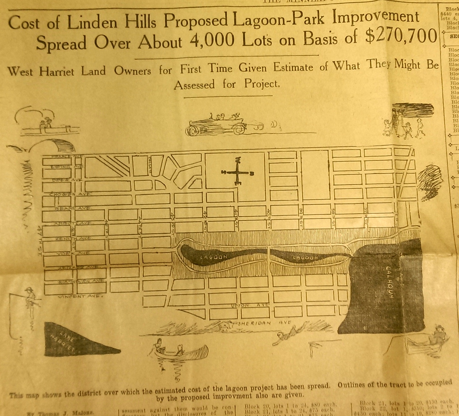
This drawing from a 1915 newspaper article shows the initial concept of a South Bay and outlines how it would be paid for. (Source: Minneapolis Sunday Tribune, June 20, 1915)
The challenge, of course was how to pay for it. The park board’s plan to assess property owners in the area for the expensive improvements was met with furiuos opposition and lawsuits. Many property owners thought that assessments they were already paying for acquisitions and improvements over the years at Lake Calhoun, Lake Harriet and William Berry Park were too heavy. The courts eventually decided in favor of the park board’s right to assess for those improvements, but by then estimated costs for the project had increased and become prohibitive and the South Bay scheme was abandoned.
Instead land for Linden Hills Park was acquired in 1919 and the surrounding wet land was drained into Lake Calhoun in the early 1920s. Dredged material from the lake was used to create a better-defined shoreline on the southwestern and northwestern shores of the lake in 1923 in preparation for the construction of the parkway.
Flowage Rights on the Mississippi River and a Canal to Brownie Lake
Minneapolis parks also lost land to water in 1916. The federal government claimed 27.6 acres of land in the Mississippi River gorge for flowage rights for the reservoir that would be created by a new dam to be built near Minnehaha Creek. Those acres, on the banks of the river and several islands in the river, would be submerged behind what became Lock and Dam No. 1 or the Ford Dam. In exchange for the land to be flooded, the park board did acquire some additional land on the bluffs overlooking the dam.
The other alteration in water courses was the dredging of a navigable channel between Cedar Lake and Brownie Lake, which completed the “linking of the lakes” that was begun with the connection of Lake of the Isles and Lake Calhoun in 1911. The land lost to the channel was negligible and probably balanced by a slight drop in water level in Brownie Lake. (A five-foot drop in Cedar Lake was caused by the opening of the Kenilworth Lagoon to Lake of the Isles in 1913.)
Another potential loss of water from Minneapolis parks may have occurred in 1917. William Washburn’s Fair Oaks estate at one time had a pond. I don’t know when that pond was filled. The estate became park board property upon the death of Mrs. Washburn in 1915. Perhaps in 1917 when the stables and greenhouses on the southwest corner of the property were demolished, the south end of the estate was graded and the pond was filled. Theodore Wirth’s suggestion for the park, presented in 1917, included an amphitheater in part of the park where the pond had once been.
The Dredge Report
The year 1917 marked the end of the most ambitious dredging project in Minneapolis parks — in fact the biggest single project ever undertaken by the park board until then, according to Theodore Wirth. The four-year project moved more than 2.5 million cubic yards of earth and reduced the lake from 300 shallow acres to 200 acres with a uniform depth of 15 feet.
That wasn’t the end of work at Lake Nokomis, however. The park surrounding the lake, especially the playing fields northwest of the lake couldn’t be graded for another five years, after the dredge fill had settled.
Dredging may again be an issue in 2017 if the Park Board succeeds in raising funds for a new park on the river in northeast Minneapolis. Dredges would carve a new island out of land where an old man-made island once existed next to the Plymouth Avenue Bridge. But that may be a long time off — and could go the way of South Bay.
Park Buzz
One other development in 1917 had more to do with standing water than was probably understood at the time. The Park Board joined with the Real Estate Board in a war on mosquitoes. However, after spending $100 on the project and realizing they would have to spend considerably more to achieve results, park commissioners terminated the project. It was not the first or last battle won by mosquitoes in Minneapolis.
As we look again at new calendars, it’s always worth taking a glance backward to see how we got here. For me, it is much easier to follow the course of events in Minneapolis park history than in American political history.
David C. Smith
Comments: I am not interested in comments of a partisan political nature here, so save those for your favorite political sites.
Minnesota River Valley National Park?
Filed under: Minneapolis parks | Tags: Friends of the Mississippi River, Harold W. Lathrop, Minnesota River, Mississippi National River and Recreation Area, National Park Service, Theodore Wirth
Comments (2) What does the Minnesota River have to do with Minneapolis parks? The Minneapolis Board of Park Commissioners, in 1934, tried to help Minnesota Gov. Floyd B. Olson convince the federal government to acquire the Minnesota River valley from Shakopee to Mendota and make it a national park.
I only have the bare bones of the story, but I wanted to throw them out there so someone else could expand it if so inclined. I find this bit of history particularly interesting in light of important efforts by Friends of the Mississippi River and the National Park Service to protect and preserve our rivers. In 1934, Gov. Olson wrote to the Minneapolis park board asking for assistance. I’ve reproduced the letter in full.
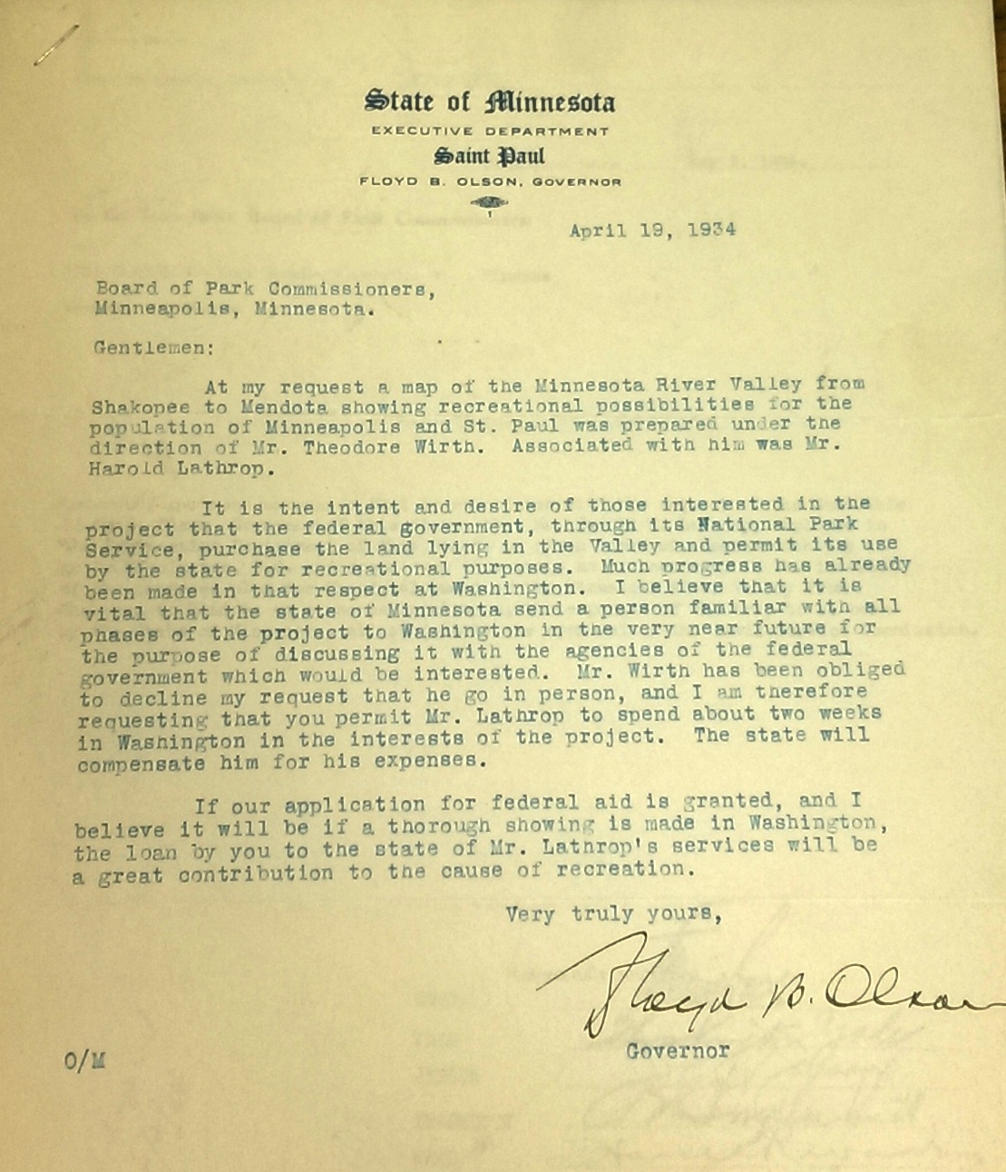
Gov. Floyd B. Olson asked the Minneapolis park board for help in creating a national park of the Minnesota River Valley in April 1934.
Always willing to cooperate on park projects, the Minneapolis park board, with Supt. Theodore Wirth’s support, voted on May 2 to give Harold Lathrop, “an employee in the Engineering Department,” leave of absence with pay to go to Washington, D.C. “and spend such time as is necessary in the interest of the proposed plan.”
It’s obvious from Gov. Olson’s letter that he had already secured the assistance of Wirth and Lathrop, and the park board presumably, in creating a map of the “recreational possibilities” of the area. I have never seen such a map created solely for that purpose, but in 1935, the park board published Theodore Wirth’s Tentative Study Plan for the West Section of a Metropolitan Park System. That report contained a detailed map of all of Hennepin County and more, including the closeup below of the Minnesota River Valley. (The full report and map are appended to the park board’s 1935 annual report.)

Detail of park possibilities in the Minnesota River Valley, Shakopee to Mendota, from a 1935 study plan by Theodore Wirth. Harold Lathrop, a park board employee in the engineering department, assisted Wirth on the report. (Minneapolis Park and Recreation Board.)
I don’t know what became of Gov. Olson’s idea of a national park when Lathrop went off to Washington, D.C. An update came a month later when, at its June 6 meeting, the park board approved Wirth’s recommendation that Lathrop be given two months leave of absence without pay “to act as Project Director for the Federal Government in connection with the proposed Minnesota River Valley development.”
Barbara Sommer writes in Hard Work and A Good Deal that Lathrop was then hired by the National Park Service, which ran the Civilian Conservation Corps (CCC), a federal work-relief program, to supervise CCC work in state parks in Minnesota. There is no indication that any of that work involved a potential park along the Minnesota River. The young National Park Service employee running the CCC program was Conrad Wirth, Theodore’s middle son. Conrad’s performance in that role set him on a trajectory to become the Director of the National Park Service in the 1960s.
I don’t believe Lathrop ever returned to the Minneapolis park board. From his job coordinating federal work in state parks, he was hired as the first director of Minnesota State Parks less than a year later in July 1935. He held Minnesota’s top state parks job until 1946, when he supposedly retired at age 45. Eleven years later, however, he became the first director of state parks in Colorado. Colorado’s first state park is named Lathrop Park.
That’s all I know of the proposed Minnesota River Valley National Park—an intrigue sparked by one letter from the governor in a correspondence file. If you know more, I’d be happy to hear from you.
David C. Smith
P.S. Timely! Friends of the Mississippi River is hosting a fundraiser tomorrow night — October 4—at the Nicollet Island Pavilion in Minneapolis. Suggested donation $100. Worthy cause! Also read the current StarTribune series on threats to the health of the Mississippi.
Update for Historians and Grammarians
Filed under: Minneapolis parks | Tags: Bassett's Creek, Beard Plaisance, Historic Minneapolis Tribune, King's Highway, Minnesota Reflections, Theodore Wirth
Leave a comment A brief Minneapolis park history update. Essential for Minneapolis historians. Trivial for grammarians.
Grammarians first: King’s Highway, Bassett’s Creek, but not Beard’s Plaisance. (This apostrophic comment was begun here.) The “pleasure ground” was originally named “The Beard Plaisance.” Perhaps the ground had been Henry Beard’s, but without pleasure. Who knows? By the time the transfer of title to the land from Beard to the park board took place, Beard’s assets were in receivership—not much pleasure in that—and the park board did end up writing his receiver a check for about eight grand. But it’s never been clear to me if that payment was for The Beard Plaisance, Linden Hills Parkway or the Lake Harriet shoreline, all of which belonged to Beard at one point. (Beard built the city’s first consciously “affordable” housing for laborers and their families. He built a block of apartments on Washington Avenue—complete with a sewage system, before the city had one—near the flour mills.)
By the way, King’s Highway was a name given by the park board to a stretch of Dupont Avenue when it asked the city to turn over that section of street as a parkway. The park board did not name Bassett’s Creek; the name was commonly used as the name for the creek about 75 years before the park board acquired the land for a park with that name.
More trivia before we get to the important stuff. The Beard Plaisance is one of four Minneapolis park properties with “the” as part of the official name. There is another with a “the” that is widely used, but was not part of an officially approved name. Can you name the other three parks with an official “the”? Bonus points for naming the one with an unofficial “the”.
Spoiler: I’ll type the names backward to give you time to think. edaraP ehT, llaM ehT, yawetaG ehT. The park property with an unofficial “the”: selsI eht fo ekaL. The lake was named long before the park board was created, and it’s usage was so widely accepted that the park board never had to adopt or approve the name—much like Calhoun, Harriet and Cedar.
Speaking of lake names, which Minneapolis lake had the most names? I’d vote for Wirth Lake, or Theodore Wirth Lake for sticklers. Previously it had been Keegan’s Lake and Glenwood Lake. Part of the original Glenwood Park, which became Theodore Wirth Park, was first named Saratoga Park, but that didn’t include what was then Keegan’s Lake.
Now the Big News for Historians
Historic Minneapolis Tribune. The digital, searchable historic Minneapolis Tribune is now back online. Thank you, thank you to all the people at the Hennepin County Library and the Minnesota Historical Society who worked hard to make this happen. Here’s the link. Woo-hoo! (Thanks to Wendy Epstein for bringing this to my attention.)
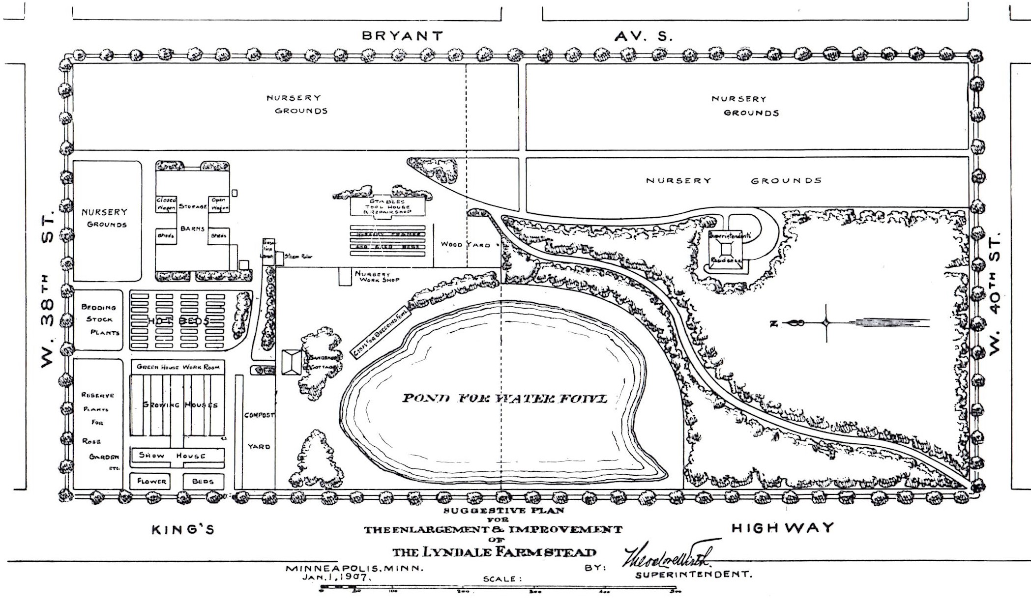
Minnesota Reflections. The Minnesota Digital Library has posted about 150 items from park board annual reports at Minnesota Reflections. The items scanned were fold-out plans, maps, charts, tables and photos that could not be properly scanned during the efforts of Google Books, Hathitrust and other libraries to digitize annual reports. Most of the fold-outs had been printed on very fragile tissue paper, so digitization has not only made them accessible, but will preserve them. I hope you have a chance to look at some of them. All were produced while Theodore Wirth was Superintendent of Minneapolis parks, when he was also the landscape architect. So they are especially useful as a means of examining his view of parks and his design priorities.
Keep in mind that most of the plans Wirth presented in annual reports were “proposals” or “suggestions” and many were never built as he first proposed. Some designs were fanciful, others represented an ideal or a wish list of amenities from which the park board usually negotiated more modest facilities. During most of Wirth’s tenure, neighborhood parks were only developed if property owners in the area agreed in advance to pay assessments on their property. Property owners essentially had veto power over park designs they considered extravagant. As plans were scaled down and the price of improvements dropped, more owners were willing to approve the assessments. Wealthier neighborhoods were more likely to approve park facilities than poorer ones, and neighborhoods with more homeowners were more likely to approve plans than neighborhoods with more apartment owners.
After several of his plans were rejected for the improvement of Stevens Square, a residential area that then, as now, was primarily apartment buildings, an exasperated Wirth urged the park board to consult not only landlords, but their tenants as well.
If you’re looking for plans relating to specific parks, you might want to consult the index of annual report plans (foldouts as well as those printed on a single-page), which I published a couple of years ago in Volume I: 1906-1915, Volume II: 1916-1925 and Volume III: 1926-1935.
There will be much more to come from the Minneapolis Park and Recreation Board on the Minnesota Reflections site, including Annual Reports and Proceedings in the public domain that are not yet on Google Books or Hathitrust, as well as, we hope, many more published after 1922. We also hope that many historical photos of Minneapolis parks will be added to the site.
Minneapolisparks.org. In case you missed it, the park board introduced a completely new website at minneapolisparks.org this spring One advantage of the new design from a history perspective is that the historical profile of each park property is accessible from its individual park page. You no longer have to download the profiles of all 190 or so parks to get the ones you want. Have a look. The park histories are a good starting point for more research. If you have questions or corrections — or interesting sidebars — on anything in those histories let me know, and I’ll either publish them here or, as appropriate, pass the corrections on to park board staff.
Since the new park pages were introduced, the links to those park histories in my posts here for the past five years are broken. I will try to update them soon, but with more than 230 articles published here, it may take me a while to get to them all.
David C. Smith
Theodore Wirth, Francis Gross and Me: A Friday Photo and a Re-assessment
Filed under: Minneapolis Park Hero, Minneapolis parks | Tags: Francis A. Gross, Hubert H. Humphrey, Lyndale Park, Theodore Wirth
Comments (2) 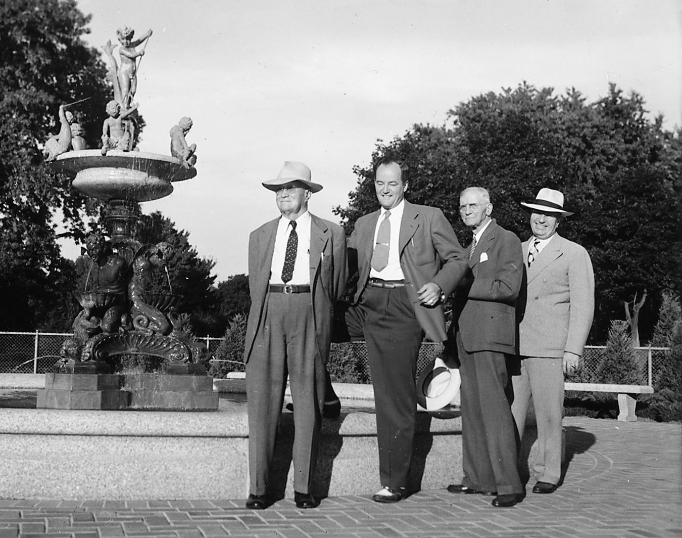
The dedication of Heffelfinger Fountain in Lyndale Park, 1947. This is the only photo I’ve seen of Theodore Wirth and Francis Gross together. They are joined by an even better-known Minneapolitan. From left: Park Superintendent Emeritus Theodore Wirth, Minneapolis Mayor Hubert H. Humphrey, Park Board President Francis A. Gross, Park Superintendent Charles E. Doell. Wirth was then 84 and Gross 77. The fountain had been discovered and purchased in Italy by Frank Heffelfinger, shipped to Minneapolis, and given to the park board. (Minneapolis Park and Recreation Board)
As I began my initial, intensive assault on Minneapolis park history in 2007 to write City of Parks, I was inclined to attribute the great success of our park system to Theodore Wirth — as so many people do. I had heard his name—attached as it was to a park, lake and parkway — for many years, and I promptly read his book on the park system—part history, part memoir.
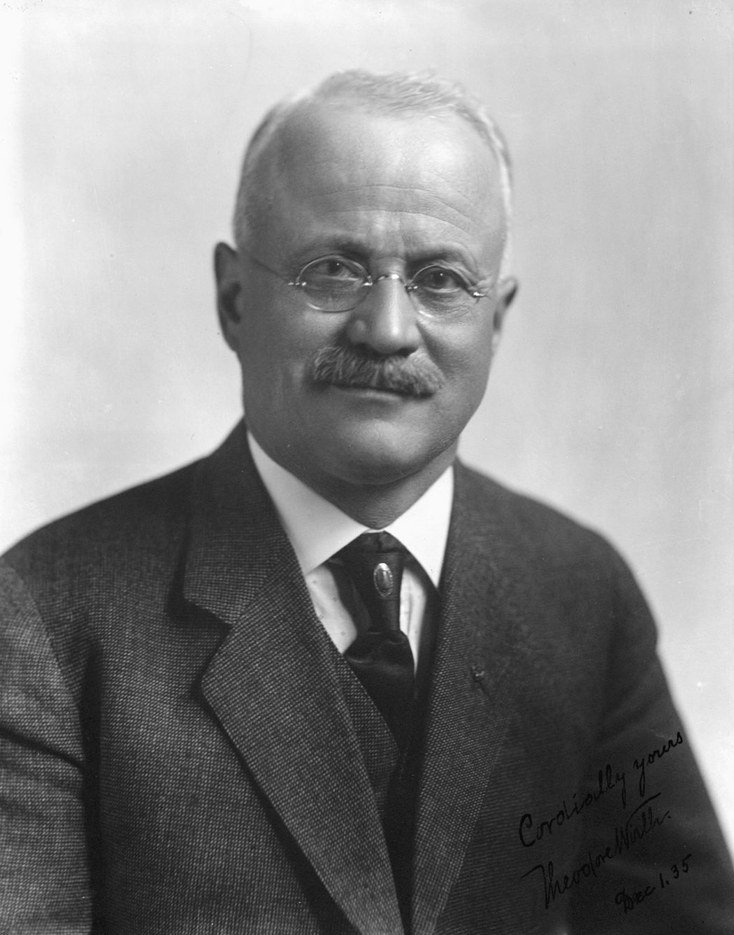
Theodore Wirth was superintendent of Minneapolis parks for 30 years, 1906-1935. (Minneapolis Park and Recreation Board)
It was the beginning of an up-and-down ride for me with Mr. Wirth and his legacy, one that I am reexamining in light of comments by Francis Gross in the autobiography he wrote in 1938.
I knew little about Wirth in 2007, but I did recall vividly being introduced to a Swedish gentleman at a party in Stockholm, Sweden in 1986 who, when he learned where I was from, gushed about what a great park planner Theodore Wirth had been. He knew much more about Wirth than I did and …Read more about how Francis Gross convinced me that Theodore Wirth was a good guy

