Troublesome Lake Hiawatha
Of all Minneapolis lakes, the one that might not exist if it hadn’t been dredged nearly a century ago is Lake Hiawatha.
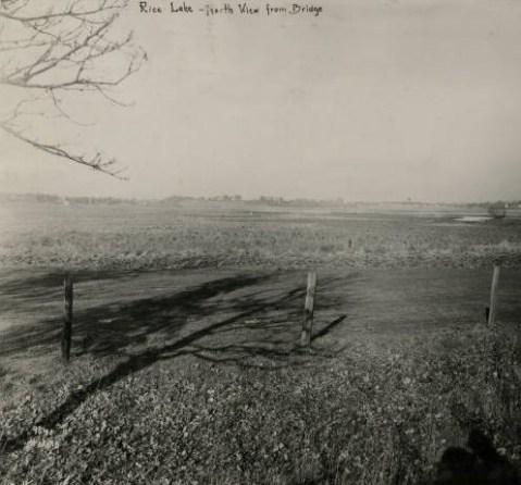
Lake Hiawatha, then Rice Lake, middle right, looking north from bridge over Minnehaha Creek in 1915. (Photo by Charles J. Hibbard from the Minneapolis Park and Recreation Board in the Minnesota Reflections Digital Library.)

Lake Hiawatha before dredging and golf course creation looking south in 1922. Lake Nokomis, with a lakeshore already defined by dredging, is on the horizon just right of center. (Hibbard, Minnesota Reflections Digital Library.)

It’s hard to tell from this 1929 photo looking east across the Lake Hiawatha and soon-to-be golf course how much water is standing. (Hibbard, Minnesota Reflections Digital Library. The same collection has many more photos of the area from different years.)
When you see the lake today, it’s hard to imagine that these photos show the same property. And it likely wouldn’t exist as a lake today if not for golf. The photos also illustrate the problems that still exist with excess water on the golf course and in the neighborhood.
Lake Hiawatha, or Rice Lake as it was called until 1925, was viewed primarily for its relationship to Minnehaha Creek for much of Minneapolis’s early history. As described in the history of Lake Hiawatha Park I wrote for the park board, the lake was viewed as a potential reservoir to maintain a constant flow of water over Minnehaha Falls. Absent that, Theodore Wirth argued that the lake would be more attractive as a meadow than a swamp and recommended draining it by diverting Minnehaha Creek through Lake Nokomis.
What changed thinking about the lake was golf. The Lake Hiawatha wetland was viewed as the only undeveloped plot of land in south Minneapolis large enough to hold a golf course. (In the late 1910s, 150 acres was considered sufficient for a golf course.) Minneapolis’s first two golf courses were at Wirth Park (then Glenwood) and Columbia Park in north Minneapolis. Gross (then Armour) and Meadowbrook golf courses, were added in the mid-1920s, both outside city limits and neither in south Minneapolis.
The other reason for maintaining Lake Hiawatha as a lake and dredging it much deeper is obvious when you look at the panoramic view above: the property was dead flat. Now I’m not a golfer, but I understand from those who are that dead flat does not make the most interesting golf courses (unless you’re being caressed by ocean breezes). To create a course that was more “sporty” in Theodore Wirth’s words, some variances in terrain would have to be created. For a park board that had little extra dirt—fill was always in demand because most neighborhood parks had been created on low lying land that was of little use, thus cheap, and needed filling—the best place to get fill was from a lake bottom. Wirth had already followed that formula at Lake of the Isles, Lake Calhoun, Cedar Lake and Lake Nokomis. He had used dredged material to reshape lakefront and create firmer shorelines. Why not dredge Lake Hiawatha, making it a “real” lake, and use the dredge “spoils” to create a golf course with (small) hills? One stone. Two birds. The results: another blue sheet of water, one less swamp (considered detrimental to health and beauy at that time), and another golf course, which proved in its early days to be one of the most profitable in the city.
Those who love the lake but hate the golf course might want to keep in mind that they may have one because of the other.
But that’s only part of the story that I’m still investigating. The other part of the story is what Theodore Wirth and park commissioners assumed about natural water levels in the Minnehaha Creek watershed. In the first few decades of the park board’s existence, water levels in the city’s lakes and creeks may have been higher than normal, although Minnehaha Creek was still dry at times. By the 1920s, however, water levels appear to have dropped and they remained low for the next few decades at least. That was when Lake Hiawatha and the Hiawatha Golf Course were created. In many years mid-century, there was no water in Minnehaha Creek except early spring and late fall. In the late 1950s water levels in the Chain of Lakes were sometimes seven feet below where they had been fifty years earlier.
The assumptions made about water levels, which affected depths of dredging and heights of filling, continue to impact how water flows or doesn’t in and around Lake Hiawatha and the golf course today when water levels are near all-time highs.
I mention this history today to remind people that a park system built around water—from the acquisition of Loring Pond and Lake Harriet in the 1880s; to renovation plans for Lake Hiawatha, Minnehaha Parkway and the Lake Calhoun boathouse site; to the development of new waterfront properties along the Mississippi River downtown and in North and Northeast—require special planning, precautions and contingencies especially in a time of climate change. Water levels will fluctuate. Know the depth before you dive.
As a postscript I’m told that some seats remain on the bus tour I’m leading of the city’s lakes, streams, ponds and river on August 17. The tour is organized by Preserve Minneapolis. Reserve your seat on the bus for the two-hour tour here.
David Carpentier Smith


[…] of south Minneapolis. Park Board superintendent Theodore Wirth had called the lake “more attractive as a meadow than a swamp.” The local press dismissed the wild rice as a weedy slough. The logic was aesthetic, […]
[…] What I have not found in those otherwise useful briefings was a recap of historical events to put water levels in perspective. So….here goes. Let’s turn the clock back again. (For more background on the creation of Lake Hiawatha and the adjacent Hiawatha Golf Course and some cool “before” photos, read my recent post Troublesome Lake Hiawatha.) […]
I grew up on both sides of the creek in the Tangletown areas in the 1950’s-60’s. It was one of our favorite playgrounds. There were some occasional seasonal and storm related wet basements then. The later regulated Gray’s Bay Dam helped.vs the early effort. Unfortunately, there are a number of lower and formerly swampy areas in Mpls that should have never been built on. These areas were certainly known, but development was allowed anyway. There is often a future price to pay for such. Factual history and science are a good basis for planning, that leadership may chose to ignore. Also a question-With the proposal to redo the creek and lake parkways, what are the funding sources for this large project? I thought the park system has had $ problems for even basic maintenance for some time now.
Oh yes, I have been wondering too about the source of the financing for all these big new plans for the parkways and parks.
Thanks for your comments Dan and Laurie.
When considering funding for projects along Minnehaha Creek it’s important to keep in mind that they are part of a Master Plan presently being prepared that will guide improvements over the next 20 years. Any of the projects actually undertaken would be spread over many years. Minnehaha Parkway is also part of a “regional” park. Since the 1970s, some parks throughout the Twin Cities have been designated as regional parks, meaning that many people outside of a taxing district use them. For instance, many visitors from around the state visit Minnehaha Parkway and Minnehaha Falls, but they don’t pay MInneapolis property tax. Therefore the state contributes money to the maintenance and improvement of those parks. Only fair! The same is true of regional parks in other cities. Other Minneapolis parks are designated as “neighborhood” parks, which serve mostly people who live near them. Those parks are paid for out of property taxes.
The case of Lake Hiawatha is further complicated, as least as far as water issues are concerned, by the fact that the Minnehaha Creek watershed extends well outside Minneapolis borders, so many agencies–city, county and state–are involved in resolving those water issues–and paying for them.
Thank you for your research and passing on this information David. We at Nokomis/Hiawatha Water Sustainability and Save Hiawatha 18 have been diligently seeking to bring officials together to study the relationship of the creek, Hiawatha, Nokomis and other parts of the watershed and how development, precipitation, and current water management is affecting those of us who live in the epicenter of the watershed. Adding more water to our already saturated community will only continue to cause costly infrastructure problems and water infiltrating basements. Your historical context is very helpful in giving people an understanding of how we need to move forward with careful decision making based on science before we make drastic changes. Many homeowners in the Nokomis and Minnehaha Creek neighborhoods are experiencing the costly effects of current water management practices. The Park Board continues to create plans without a comprehensive understanding of how each change will affect others downstream. Thank you for your continued efforts to enlighten people through facts and history!
Thanks, Joan. I know these are very complex issues and I appreciate your efforts to address them. There is always an upstream and a downstream!
Another really interesting and needed perspective. I have a cabin on the Upper St. Croix river and am all too aware that in the end, water will do what water wants to do, no matter how we attempt to “control” it.
Thanks, Laurie. A contractor friend says, “Water always wins.” But what an incredible treasure it is for the health and beauty–the park board’s motto–of our city and state.
As always, David, wonderful retelling of history and great perspective.
Thanks, Joe. Good to hear from you. (Joe wrote a fun book on Minnesota golf courses — Fore! Gone: Minnesota’s Lost Golf Courses 1897-1999. Minnesota golfers should have a copy.
Hi – I would like to share your article about Lake Hiawatha to a local FB group. Do I have your permission? Also, I don’t see a “share” button. Maybe that’s on purpose!
Thanks –
Rita Sandstrom
Hi Rita, Thanks for reading. Please do share it with others. I’ll look into adding a share button.