Archive for the ‘Bassett’s Creek’ Tag
Update for Historians and Grammarians
Filed under: Minneapolis parks | Tags: Bassett's Creek, Beard Plaisance, Historic Minneapolis Tribune, King's Highway, Minnesota Reflections, Theodore Wirth
 Leave a comment
 A brief Minneapolis park history update. Essential for Minneapolis historians. Trivial for grammarians.
Grammarians first: King’s Highway, Bassett’s Creek, but not Beard’s Plaisance. (This apostrophic comment was begun here.) The “pleasure ground” was originally named “The Beard Plaisance.” Perhaps the ground had been Henry Beard’s, but without pleasure. Who knows? By the time the transfer of title to the land from Beard to the park board took place, Beard’s assets were in receivership—not much pleasure in that—and the park board did end up writing his receiver a check for about eight grand. But it’s never been clear to me if that payment was for The Beard Plaisance, Linden Hills Parkway or the Lake Harriet shoreline, all of which belonged to Beard at one point. (Beard built the city’s first consciously “affordable” housing for laborers and their families. He built a block of apartments on Washington Avenue—complete with a sewage system, before the city had one—near the flour mills.)
By the way, King’s Highway was a name given by the park board to a stretch of Dupont Avenue when it asked the city to turn over that section of street as a parkway. The park board did not name Bassett’s Creek; the name was commonly used as the name for the creek about 75 years before the park board acquired the land for a park with that name.
More trivia before we get to the important stuff. The Beard Plaisance is one of four Minneapolis park properties with “the” as part of the official name. There is another with a “the” that is widely used, but was not part of an officially approved name. Can you name the other three parks with an official “the”? Bonus points for naming the one with an unofficial “the”.
Spoiler: I’ll type the names backward to give you time to think. edaraP ehT, llaM ehT, yawetaG ehT. The park property with an unofficial “the”: selsI eht fo ekaL. The lake was named long before the park board was created, and it’s usage was so widely accepted that the park board never had to adopt or approve the name—much like Calhoun, Harriet and Cedar.
Speaking of lake names, which Minneapolis lake had the most names? I’d vote for Wirth Lake, or Theodore Wirth Lake for sticklers. Previously it had been Keegan’s Lake and Glenwood Lake. Part of the original Glenwood Park, which became Theodore Wirth Park, was first named Saratoga Park, but that didn’t include what was then Keegan’s Lake.
Now the Big News for Historians
Historic Minneapolis Tribune. The digital, searchable historic Minneapolis Tribune is now back online. Thank you, thank you to all the people at the Hennepin County Library and the Minnesota Historical Society who worked hard to make this happen. Here’s the link. Woo-hoo! (Thanks to Wendy Epstein for bringing this to my attention.)
Minnesota Reflections. The Minnesota Digital Library has posted about 150 items from park board annual reports at Minnesota Reflections. The items scanned were fold-out plans, maps, charts, tables and photos that could not be properly scanned during the efforts of Google Books, Hathitrust and other libraries to digitize annual reports. Most of the fold-outs had been printed on very fragile tissue paper, so digitization has not only made them accessible, but will preserve them. I hope you have a chance to look at some of them. All were produced while Theodore Wirth was Superintendent of Minneapolis parks, when he was also the landscape architect. So they are especially useful as a means of examining his view of parks and his design priorities.
Keep in mind that most of the plans Wirth presented in annual reports were “proposals” or “suggestions” and many were never built as he first proposed. Some designs were fanciful, others represented an ideal or a wish list of amenities from which the park board usually negotiated more modest facilities. During most of Wirth’s tenure, neighborhood parks were only developed if property owners in the area agreed in advance to pay assessments on their property. Property owners essentially had veto power over park designs they considered extravagant. As plans were scaled down and the price of improvements dropped, more owners were willing to approve the assessments. Wealthier neighborhoods were more likely to approve park facilities than poorer ones, and neighborhoods with more homeowners were more likely to approve plans than neighborhoods with more apartment owners.
After several of his plans were rejected for the improvement of Stevens Square, a residential area that then, as now, was primarily apartment buildings, an exasperated Wirth urged the park board to consult not only landlords, but their tenants as well.
If you’re looking for plans relating to specific parks, you might want to consult the index of annual report plans (foldouts as well as those printed on a single-page), which I published a couple of years ago in Volume I: 1906-1915, Volume II: 1916-1925 and Volume III: 1926-1935.
There will be much more to come from the Minneapolis Park and Recreation Board on the Minnesota Reflections site, including Annual Reports and Proceedings in the public domain that are not yet on Google Books or Hathitrust, as well as, we hope, many more published after 1922. We also hope that many historical photos of Minneapolis parks will be added to the site.
Minneapolisparks.org. In case you missed it, the park board introduced a completely new website at minneapolisparks.org this spring One advantage of the new design from a history perspective is that the historical profile of each park property is accessible from its individual park page. You no longer have to download the profiles of all 190 or so parks to get the ones you want. Have a look. The park histories are a good starting point for more research. If you have questions or corrections — or interesting sidebars — on anything in those histories let me know, and I’ll either publish them here or, as appropriate, pass the corrections on to park board staff.
Since the new park pages were introduced, the links to those park histories in my posts here for the past five years are broken. I will try to update them soon, but with more than 230 articles published here, it may take me a while to get to them all.
David C. Smith
Glenwood Spring: A Premier Park — and Water Supply?
Filed under: Minneapolis Parks: General | Tags: Bassett's Creek, Bassett's Creek Valley Park, H.W.S. Cleveland, Horace Cleveland
Comments (1) H.W.S. Cleveland, the landscape architect who created the blueprint for Minneapolis’s park system in 1883, made his first visit to Glenwood Spring near Bassett’s Creek in north Minneapolis in the spring of 1888. In a letter to the Minneapolis Tribune, published April 22, 1888. Cleveland described that visit.
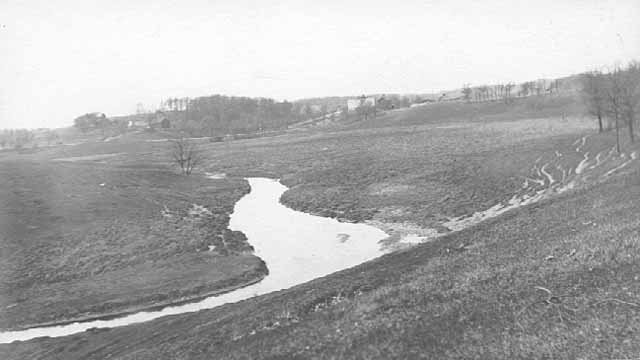
Bassett’s Creek in the vicinity of Glenwood Spring, about 1910 according to the Minnesota Historical Society. I’m not familiar enough with the lay of the land in the area to guess the exact location of this scene, but I was struck by how open the landscape was, especially given Horace Cleveland’s description of “large bodies of very fine native trees” in the vicinity of the spring. Perhaps those groves were behind the photographer. (Minnesota Historical Society)
Cleveland’s letter addressed the subject of the city’s water supply, noting that when he and his family moved to Minneapolis from Chicago in 1886 they experienced deleterious health effects — “winter cholera,” as he put it — that they thought might be associated with Minneapolis tap water. He reported that after they began using Glenwood spring water his family had no further health issues and they also found the spring water more “palatable” than the city water, which was taken from the Mississippi. Cleveland wrote that he had used the spring water for more than a year before he visited the neighborhood of the springs. When he finally did visit,
“I was not alone surprised and delighted by the beauty of the springs themselves, and their topographical surroundings, but amazed and grieved that my attention had not been called to the locality when I first came by invitation of the park commissioners, five years previous, to study the possibilities of park improvements.”
Cleveland claimed that because he was put in charge of an engineer, Frank Nutter, who, he was told, was familiar with all the sites desirable for park purposes, he didn’t feel it necessary to look at areas he was not shown. Cleveland didn’t believe he was deceived or misled, but…
“An hour’s inspection of the area in the neighborhood of these springs satisfied me that no place in the neighborhood of the city, except the vicinity of Minnehaha falls, was so well adapted by nature for the construction of a park, comprising rarely attractive topographical features — while the distance from the center of business was less than half that to Minnehaha, and the apparently unlimited capacity of the springs, which gushed from the hillsides at various points over a widely extended area, seemed to offer every possible opportunity for the ornamental use of water.”
The prospect of bubbling springs of clear water and “hills and valleys of graceful form” that wouldn’t have needed “heavy expense in grading” to be transformed into parkland appealed to Cleveland’s aesthetic sense. He also asked “whether it is worth our while to ascertain the character and capacity of the springs” to supply the entire city with water. Cleveland suggested that if the springs were capable of meeting the city’s water needs, “the city should secure them, and enough land around them to preserve them from contamination, and then enclose the area as an ornamental reservoir as had been done in Philadelphia, New York and Boston.

This photo of the ice house at Inglewood spring was taken in the mid-1890s. (Minnesota Historical Society)
What Cleveland didn’t know at the time was that the Glenwood and Inglewood springs may not have been well-known in 1883, when Nutter hosted Cleveland’s park exploration visit. Most accounts I can find of Glenwood Spring’s history claim it was discovered by William Fruen in 1884, a year after Cleveland wrote his “Suggestions for a System of Parks for the City of Minneapolis.” One account suggests Fruen found the springs in 1882. Some accounts have him discovering Glenwood Spring when building a mill on Bassett’s Creek, others when he was digging a fish pond. The latter tale, probably a tall one, was disseminated on the cached web site of the Glenwood Inglewood Water Company.
Fruen’s history with the spring includes filing the first vending machine patent in U. S. history. He invented a coin-operated machine in 1884 to dispense his spring water by the glass. Fruen also attempted to distribute his water by pipeline as Cleveland thought might be desirable. John West, owner of the posh West Hotel in Minneapolis, Thomas Lowry and Fruen wanted to build a two-mile pipeline from the spring to the West Hotel, and also sought permission to pipe the water into homes and restaurants along the way. That plan was vetoed in 1885 by Mayor George Pillsbury.

The Glenwood-Inglewood Company, 1910. The Glenwood and Inglewood springs were on adjacent property and run as separate water companies until about 1896. Until then, they were competitors. See below. (Minnesota Historical Society)
In the spring of 1885, Fruen published ads in the Tribune touting the purity of water from Glenwood Spring. He published a chemical analysis of the water conducted by Professor James Dodge of the University of Minnesota, who attested, “This water is extremely pure, being almost entirely free from organic matter.”
The ad invited readers to, “Drive out and see as fine a spring as you ever looked upon.” Another admonition in the copy is particularly interesting given the long association in later years of the Glenwood and Inglewood springs:
“Do not confound this spring with the Inglewood. Ours is the Glenwood.”
William Fruen’s son, Arthur, donated 13 acres of land along Bassett’s Creek to the park board in 1930, which was the beginning of Bassett’s Creek Valley Park. Arthur Fruen was a city council member at the time and an ex-officio member of the park board. I don’t know if that 13 acres included the site of the original spring—in other words, if Cleveland’s vision of a park that included the spring was partially realized nearly 50 years after he first saw it.
David C. Smith
© David C. Smith
1955 Was a Very Dry Year
Filed under: Minneapolis parks | Tags: Bassett's Creek, Brownie Lake, Fairchild Aerial Surveys, Lake Calhoun, Lake of the Isles, Minnehaha Creek, Mississippi River, St.Anthony Falls
Comments (9) It’s not a common sight. I’d never seen it myself until I saw this picture from Fairchild Aerial Surveys taken in 1955. St. Anthony Falls is completely dry.

The concrete apron at St. Anthony Falls is bone dry in 1955. The 3rd Avenue Bridge crosses the photo. Dry land — even a small structure — left (west) of the falls stand where the entrance to the lock is now. (Fairchild Aerial Surveys, Minneapolis Park and Recreation Board)
Water levels were down everywhere at the time. Meteorological charts list 1955 as the 13th driest year on record in Minneapolis, but a look at longer-term data reveal that rainfall had been below normal for most of the previous 40 years. Downstream from St. Anthony Falls, the river was also very low, revealing the former structure of the locks at the Meeker Island Dam.

The old lock structure from the Meeker Island Dam protrudes from the low water in 1955. The old lock and dam between Franklin Avenue and Lake Street were destroyed when the new “high dam” or Ford dam was built near the mouth of Minnehaha Creek downriver. (Fairchild Aerial Surveys, Minneapolis Park and Recreation Board)
That dry spell had a significant impact on park property. Many park board facilities, from beach houses to boat houses and docks, were permanent structures that required proximity to the water’s edge. Parks were also landscaped and mowed to the water line and, since the depression, at least, many lakes had WPA-built shore walls that looked goofy a few feet up on dry land.
Park board annual reports provide time-lapse updates.
1948: Minnehaha Creek dry most of the year, lakes down 1.5 feet.
1949: Chain of Lakes 2 feet below normal, rainfall 2.5 inches below normal, water in Minnehaha for limited time during year
1950: Lake levels at record lows, lake channels dredged 4.5 feet deeper to allow continued use, water in Minnehaha Creek for only brief period in spring
1951: Record snowfall and heavy rains raised lake levels 0.44 feet above normal in April; flooding problems along Minnehaha Creek golf courses required dikes to make courses playable; attendance at Minnehaha Park high all year due to impressive water flow over falls.
1952: Wet early in year, dry late; lake levels stable except those that depend on groundwater runoff, such as Loring Pond and Powderhorn Lake, which were down considerably at end of year
1953: Lake levels fluctuated 1.5 feet from early summer to very dry fall; flow in Minnehaha Creek stopped in November; U.S. Geological Survey began testing water flow in Bassett’s Creek for possible diversion
1954: Again, water level fluctuations; near normal in early summer, low in fall; Minnehaha Creek again dry in November.
1955: Fall Chain of Lakes elevation lowest since 1932, but Lake Harriet near historical normal; Minnehaha dry most of year
1956: Lakes 4 feet below normal, weed control required, boat rentals incurred $10,000 loss
1957: City water — purchased at a discount! — pumped into lakes raised lake levels 1.5 feet; park board began construction of $210,000 pipeline from Bassett’s Creek, which, unlike Minnehaha Creek, had never been completely dry, to Brownie Lake.
1958: Second driest year on record; Minnehaha Creek dry second half of year; pumps activated on pipeline from Bassett’s Creek, raised water level in lakes 4.2 inches by pumping 84,000,000 gallons of water.
1959: Dry weather continued; Park board suggested reduction in water table may be result of development; Park board won a lawsuit against Minikahda Club for pumping water from Lake Calhoun to water golf course. When Minikahda donated lake shore to park board for West Calhoun Parkway in 1908 it retained water rights, but a judge ruled the club couldn’t exercise those rights unless lake level was at a certain height — higher than the lake was at that time — except in emergencies when it could water the greens only. Lakes were treated with sodium arsenite to prevent weed growth in shallower water; low water permitted park crews to clean exposed shorelines of debris.
1960: Lake levels up 4 feet due to pumping and rain fall; channels between lakes opened for first time in two years; hydrologist Adolph Meyer hired to devise a permanent solution to low water levels.

To celebrate the rise in water levels sufficient to make the channels between the lakes navigable after being closed for a couple of years, park superintendent Howard Moore helped launch a canoe in the channel between Lake of the Isles (in background) and Lake Calhoun in 1960. He seems not to mind that one foot is in the drink. (Minneapolis Park and Recreation Board)
That’s more than a decade’s worth of weather reports. The recommendation of hydrologist Adolph Meyer was very creative: collect and recycle water from the air-conditioners in downtown office buildings and stores, and pump it to the lakes. That seemed like a good idea until the people who ran all those air-conditioners downtown thought about it and realized they could recycle all that water themselves through their own air-conditioners and save a lot of money on water bills. End of good idea. Instead the park board extended its Chain of Lakes pumping pipeline from Bassett’s Creek all the way to the Mississippi River. But that’s a story for another time.
If you’ve followed the extensive shoreline construction at Lake of the Isles over the last many years, you know that water levels in city lakes remains an important, and costly, issue—and it probably always will be. It’s the price we pay for our city’s water-based beauty.
David C. Smith
Afterthought: The lowest I ever remember seeing the river was following the collapse of the I-35W bridge. The river was lowered above the Ford Dam to facilitate recovery of wreckage from that tragedy. Following a suggestion from Friends of the Mississippi River, my Dad and I took a few heavy-duty trash bags down to the river bank near the site of the Meeker Island Dam to pick up trash exposed by the lower water levels. Even then the water level wasn’t as low as in the Fairchild photos.
More Bassett’s Creek
Filed under: Minneapolis parks, Minnehaha Creek | Tags: Bassett's Creek, Minnehaha Creek, Neiman Sports Complex
Leave a comment Interesting thoughts from readers on city and park board treatment of Bassett’s Creek:
Is it possible that Minneapolis spent as much or more tunneling Bassett’s Creek in an attempt to improve north Minneapolis than it spent building a parkway along Minnehaha Creek? Someone would have to go through financial reports to determine the city/Bassett’s Creek figures. Building two tunnels, the second one 80 feet beneath downtown Minneapolis, must have had a fairly hefty price tag. What if you threw in the federal and park board dollars from the time of Civilian Conservation Corps and Works Progress Administration projects in the 1930s until now on Bassett’s Creek above ground from Bryn Mawr into Theodore Wirth Park?
Perhaps the park board’s biggest missed opportunity in dealing with Bassett’s Creek was the decision to build a competition-quality youth sports complex—the one named for Leonard Neiman—at Fort Snelling instead of in Bryn Mawr/Harrison. I don’t recall what Bryn Mawr or Harrison residents thought of the idea when it was considered in the late 1990s. Does anyone remember that discussion? It would certainly be a better location for youth sports than the distant fields of Fort Snelling (for people living almost anywhere in Minneapolis—south, north, northeast, or southeast). Whether building that complex in the central city would have spurred other development or at least raised awareness of Bassett’s Creek is hard to say, but it could’ve been positive for the neighborhoods beside and above the creek.
David C. Smith
The Myth of Bassett’s Creek
Filed under: Minneapolis parks, Mississippi River | Tags: Bassett's Creek, H.W.S. Cleveland, Horace Cleveland, Minnehaha Creek, Mississippi River
Comments (24) I heard again recently the old complaint that north Minneapolis would be a different place if Bassett’s Creek had gotten the same treatment as Minnehaha Creek. Another story of neglect. Another myth.
You can find extensive information on the history of Bassett’s Creek online: a thorough account of the archeology of the area surrounding Bassett’s Creek near the Mississippi River by Scott Anfinson at From Site to Story — must reading for anyone who has even a passing interest in Mississippi River history; a more recent account of the region in a very good article by Meleah Maynard in City Pages in 2000; and, the creek’s greatest advocate, Dave Stack, provides info on the creek at the Friends of Bassett Creek , as well as updates on a Yahoo group site. Follow the links from the “Friends” site for more detailed information from the city and other sources.
What none of those provided to my satisfaction, however, was perspective on Bassett’s Creek itself after European settlement. A search of Minneapolis Tribune articles and Minneapolis City Council Proceedings, added to other sources, provides a clearer picture of the degree of degradation of Bassett’s Creek — mostly in the context of discussions of the city’s water supply. This was several years before the creation of the Minneapolis Board of Park Commissioners in 1883 — a time when Minnehaha Creek was still two miles outside of Minneapolis city limits. The region around the mouth of Bassett’s Creek was an economic powerhouse and an environmental disaster at a very early date — a mix that has never worked well for park acquisition and development.

Idyllic Minnehaha Creek, still in rural surroundings around 1900, quite a different setting than Bassett’s Creek, which had already been partly covered over by then. (Minnesota Historical Society)
“A Lady Precipitated from Bassett’s Creek Bridge”
Anfinson provides many details of the industrial development of the area around the mouth of Bassett’s Creek from shortly after Joel Bean Bassett built his first farm at the junction of the river and the creek in 1852. By the time the Minneapolis Tribune came into existence in 1867, industry was already well established near the banks of the creek. A June 1867 article relates how the three-story North Star Shingle Mill had been erected earlier that year near the creek. The next March an article related the decision to build a new steam-powered linseed oil plant near the creek on Washington Avenue.
Even more informative is a June 27, 1868 story about an elderly woman who fell from a wagon off the First Street bridge over the creek. “A Lady Precipitated from Bassett’s Creek Bridge, a Distance of Thirty Feet,” was the actual headline. (I’m a little embarrassed that I laughed at the odd headline, which evoked an image of old ladies raining down on the city; sadly, her injuries were feared to be fatal.) But a bridge height of thirty feet? That’s no piddling creek — even if a headline writer may have exaggerated a bit. The article was written from the perspective that the bridge was worn out and dangerous and should have been replaced when the city council had considered the matter a year earlier. Continue reading

