Archive for the ‘Lake Calhoun’ Tag
H.W.S. Cleveland: Old New Posts
Filed under: Minneapolis parks | Tags: Bde Maka Ska, Frederick Law Olmsted, H.W.S. Cleveland, Lake Calhoun, Lake Harriet, Theodore Wirth
 Leave a comment
 A few years ago I deleted several posts on this site about Horace William Shaler Cleveland because I intended to use that information in a biography of Cleveland. I have since been distracted from that project and while I still plan to pick it up again, I thought it useful to re-post some of that information about a man who contributed so much to Minneapolis’s quality of life. So for the next few days I will post some of those hidden historical nuggets about Cleveland and his work in Minneapolis parks. I think much of the information I have discovered about Cleveland’s interactions with Frederick Law Olmsted may also be of interest due to the extensive coverage of Olmsted’s work in the past year.
The first “re-post” is from 2010 when I wrote about the history of plans to connect Lake Calhoun to Lake Harriet by a canal. (When I wrote these pieces about Lake Calhoun that was still it’s legal name. It has since been changed to Bde Maka Ska, but I have not edited those articles to reflect the new name.)
Connecting Lake Harriet and Lake Calhoun
David C. Smith
Minneapolis Park Names Added and Reconsidered
Filed under: Minneapolis parks | Tags: Bde Maka Ska, Ed Currie, Lake Calhoun, LeRoy Hardeman, Pillsbury House
Comments (8) In light of rekindled debates over park names, prompted by the Appeals Court decision rescinding the name change of Lake Calhoun to Bde Maka Ska, the park board’s vote to alter the process for changing parkway names, and debate at the University of Minnesota over changing building names, I revisited my compilation of people commemorated in Minneapolis parks.
I just added two names that were designated since I originally compiled that list.
- Annie Young: the meadow in Riverside Park was named to honor the former park commissioner who died in 2018.
- Mary Merrill: the headquarters building of the Minneapolis Park and Recreation Board, previously unnamed, was named after the former park superintendent and park commissioner, known then as Mary Merrill Anderson, who also served as the acting superintendent in 2018.
Changing Names
The park board suspended its naming rules to approve both names, which had also been done in recent years to name park baseball fields for Rod Carew, Frank Quilici and Sid Hartman. Previous board policy had prevented naming park properties for people still living or for a couple years after they died. The policy was refined after controversy in 1964 over the naming of Todd Park across Portland Avenue from Diamond Lake. George Todd was a park commissioner dying of cancer at the time. The objective was to honor him while still living for his work in creating the park . The policy was also suspended in 1968 to rename Nicollet Field for Martin Luther King, without a waiting period, shortly after his murder.
The park board also, with little discussion, has altered the process for changing parkway names. Continue reading
Linden Hills Boulevard: The Carriage Route to Lake Harriet
Filed under: Minneapolis Parks: General | Tags: Lake Calhoun, Lake Harriet, Linden Hills Boulevard
Comments (6) At a recent picnic with friends who live south of Lake Harriet (Happy Birthday Kathryn!), they were surprised when I told them that the first park connection between Lake Calhoun and Lake Harriet was not William Berry Parkway (which was named Shady Lane until 1968), but Linden Hills Boulevard. The boulevard was conceived as a scenic approach on the ridge overlooking Lake Harriet and the final link from Central (Loring) Park via Kenwood Parkway to Lake of the Isles, around that shoreline and the eastern shore of Lake Calhoun to Lake Harriet.
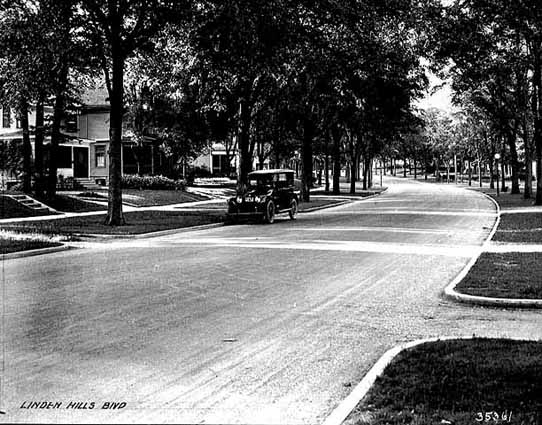
Freshly paved Linden Hills Boulevard in 1921. (Minnesota Historical Society, MH5.9 MP2.2 p31.)
Given the recent interest expressed in the boulevard, I am posting a brief history of the parkway I had written originally for the Park Board website (minneapolisparks.org).
Location: William Berry Parkway to Queen Avenue at West Lake Harriet Parkway
Size: 5.71 acres
Name: The land was referred to as Park Boulevard in park board documents for about 25 years until it was officially named Linden Hills Boulevard, after the surrounding neighborhood, in 1912.
Acquisition and Development: From the first time that Linden Hills Boulevard was included as a separate item in the park board’s inventory in 1914, it was described as having been donated by Henry Beard in 1888. However in 1888, the board paid $8,342 for “satisfaction of Beard contract” which included two years and three months worth of interest on an original amount of $7,200 that the park board owed him. It is unclear what land is referred to in the “Beard contract.” It could include portions of the Lake Harriet shore as well as Beard Plaisance or Linden Hills Boulevard. Beard was one of the original donors of the land around Lake Harriet for park purposes.
Park Boulevard was created to link Lake Calhoun to Lake Harriet. Using the math from the report on the Beard contract, the original deal to acquire the land dated to 1886. The boulevard was intended to be the primary connection between the two lakes until a more direct route between the lakes, eventually named William Berry Parkway, was acquired in 1889.
The boulevard was graded and planted in 1889. In the park board’s 1889 annual report, Charles Loring describes it as the “high land west of the Motor track, overlooking the lake.” At that time there were no homes between the boulevard and the lake. The Motor track Loring referred to was the street railway track. The initial layout of the boulevard was a 40-foot-wide driveway flanked by 10-foot-wide walkways and 20-foot-wide planting spaces, which were covered with loam and seeded.
The first homes on the boulevard were not built for a few years after initial improvements were made. The oldest existing homes along the boulevard, built in 1894, include the house at the corner of 40th St. West and 4208 Linden Hills Boulevard according to Hennepin County’s Interactive property map. A house between the Boulevard and Lake Harriet was built at 4236 Queen Avenue in 1897. The rest of the houses on Queen Avenue and the Boulevard were built in 1900 or later. (Additional research in February 2022 by the other David C. Smith and the Linden Hills History Study Group reveals that building permits were taken out in 1894 also for houses at 4200, 4220 and 4228 Linden Hills Boulevard, all on the west side of the boulevard, and for 4224 Queen Avenue South between the boulevard and the lake. Those four houses are listed on the interactive map as built in 1900.)
Original improvements to the Boulevard in 1889 also included a 70-foot viaduct at the end of the boulevard over the street railway tracks at Queen Avenue. The total cost of the improvements was nearly $7,000. The street railway rebuilt the Queen Avenue bridge in 1905 following extensive negotiations with the park board over who was responsible for it. The park board refused to repair the bridge, because it believed the street railway was responsible.
The Linden Hills Boulevard was improved significantly in 1912 at a cost of nearly $5,000 even though it was no longer the main link from Calhoun to Harriet. With the improvements that year came pressure for a more suitable name than Park Boulevard. The board chose the name Linden Hills Boulevard.
The boulevard was paved for the first time in 1921. The entire length of the parkway was repaved in 1993.
Most of the parkways in Minneapolis were officially named “boulevards” until 1968 when they were all renamed “parkways” to indicate more clearly that they were park property. (They were also later paved with a distinctive red-tinted asphalt to further distinguish them from ordinary city streets.) However, Linden Hills Boulevard was overlooked at the time and is, therefore, the only road owned by the park board still officially called a boulevard—even though it, too, is paved red.
David C. Smith
Restored Posts: Makwa Club, Toboggans, Building Restrictions, Parkways
Filed under: Minneapolis Parks: General | Tags: Calhoun Parkway, Dean Parkway, Harry Perry Robinson, Lake Calhoun
Comments (4) In response to requests and my own whimsy I have restored several posts to these pages today.
I restored one post at the request of author Joe McAleer, whom I met through these pages. He is just finishing a biography of one of the most fascinating characters I’ve come across in Minneapolis history, Harry Perry Robinson. Joe’s book is entitled Escape Artist: The Nine Lives of Harry Perry Robinson, which is due out in June 2019 from Oxford University Press. Robinson visited Minneapolis as a young Englishman right out of college in the 1880s and made the city his home for several years while writing for local newspapers, becoming besties with many influential Minneapolitans and marrying the daughter of Thomas Lowry. He achieved his greatest fame as a correspondent covering World War I from the trenches of France for London newspapers and was knighted for his efforts. I’m really looking forward to reading his life story.
Due to a link in the piece Robinson inhabits on this site, I also restored some of my favorite photos: the toboggan slide from Queen Avenue out onto Lake Harriet. There is much to see in those images from 1914.
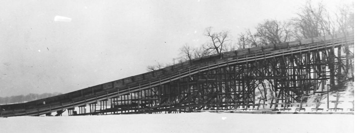
The impressive structure of the Lake Harriet toboggan slide (Minneapolis Park and Recreation Board)
Given continuing discussions of building near Minneapolis lakes, I wanted to restore a piece I wrote a few years ago about how the city passed the first ordinance limiting building heights around lakes. It was passed in 1912 in response to a threat to build a hotel beside Lake of the Isles at 25th Street.
I also reposted stories on the intersection of Dean Parkway and Calhoun Parkway.
I’ve reposted a few other pieces that seemed worthwhile, which I’ll let you discover for yourself by scrolling through the site.
David C. Smith
In the past I included my email address on everything I posted here, but due to the volume of spam I received I had to quit doing that. But you can always reach me by posting a comment on some post or page on this site. Every comment is reviewed before it is posted, so they all come to my attention.
G’day Maka Ska, G’bye Calhoun?
Filed under: Minneapolis Lakes, Minneapolis Park Board, Minneapolis Parks: General | Tags: Bde Maka Ska, Lake Calhoun
Comments (14) Efforts to eradicate the name Lake Calhoun and replace it with Bde Maka Ska have generated a great deal of discussion and passion on many sides. The usage of the recommended new name and its meaning and pronunciation have been badly muddled, however, which confuses the issues unnecessarily.
Let me, a non-Dakota speaker, try to clarify. Bde Maka Ska is one of the Dakota names for the lake that was named Lake Calhoun by white surveyors or soldiers sometime before 1820. We have been told often that the term translates as White Earth Lake. So far, so good. But let’s break it down further.
Translation
Bde: lake
Maka: earth
Ska: whitePronunciation
Bde: The “e”, as in Spanish, is more like “ay” as in day. Hear Crocodile Dundee saying “G’day, mate.” Say b’day like an Australian caricature says “g’day” — rather than b-day which suggests a pronunciation more like a fixture in a French bathroom. G’day. B’day. Closer to one syllable than two.
Makaska: I’ve cheated and put the two words together, which to my ear is how Dakota speakers pronounce them. All a’s are pronounced as in “Ma” for mother. Accent the middle syllable, as if you were saying “my Costco.” MaCostco. Makaska.
This is the easy part and should not have any bearing on the merits of changing the name. It’s not hard to say, so let’s not use that excuse. How do you know how to pronounce “Isles” in “Lake of the Isles” with two of five letters silent? You learned — and thought nothing of it. Not difficult.
Usage
This is a little trickier. I don’t know Dakota patterns of usage, but to my view the Minneapolis park board’s master plan entitled Calhoun/Bde Maka Ska-Harriet, which recommended the name change, is confusing. If we are dropping “lake” from Lake Calhoun and Lake Harriet, in this context shouldn’t we also drop “bde” from Bde Maka Ska. Otherwise it would be Lake Lake White Earth.
In other words, Bde Maka Ska replaces Lake Calhoun, not just Calhoun. Maybe Dakota grammarians would box your ears if you said the equivalent of, “I’m going to bike around Maka Ska this afternoon.” Maybe in Dakota “lake” or “bde” must always be part of a lake name. But if the “bde” doesn’t have to bde there, couldn’t the park board have approved renaming the lake “Maka Ska”? I ask in part because I haven’t heard any objection to the word “lake” itself, although Tony Lake, Lake Street, and Veronica Lake all have had detractors. (I’ve never seen her right eye!)
It matters because any use of Calhoun alone then is unaffected, which is a bit exasperating, because that’s the objectionable part. So on the parkway signs that say East (or West) Calhoun Parkway it was incorrect to add Bde Maka Ska, as was done last year. Only signs that say “Lake Calhoun” should have been changed. Even the vandals of signs at Lake Calhoun last year didn’t know what they were doing when they replaced only Calhoun, but not Lake, with Bde Maka Ska. Pretty ignorant activism.
I raise this issue primarily for clarification. We know some lakes around the world by their indigenous names, Loch Ness comes to mind, and others have retained names given by non-English speakers, such as Lac qui Parle in western Minnesota (not just a lake but a county), a French translation of the Dakota words “lake that speaks”. (Was “bde” part of that Dakota name?)
Something to Consider
So… how should we treat Bde Maka Ska? Wouldn’t it be easier to discuss the merits of a name change if we said we wanted to change the name from Lake Calhoun to Lake Maka Ska? Dakota and Ojibwe names for lakes and places abound in Minnesota and no one seems to have a problem with that. Yet I’ve never seen any other lake named Bde Anything. There are many a “mni” — Dakota for “water” — anglicized to Minnetonka, Minnesota, Minnehaha, but not a “bde” that I know of.
I suspect that some people opposed to renaming the lake get hung up on “bde” for “lake”. It’s a diversion from the real issues, which are, “Calhoun or not?” And, “If not, what?” Lake Maka Ska might eventually be adopted by those who don’t speak Dakota. Bde Maka Ska will take decades longer — if the bde isn’t dropped quickly anyway.
Where Does the Name Come From?
Knowing a bit of the history of Lake Calhoun since 1820, I’m also curious how the lake got the name “White Earth”. We know that parts of the shoreline, especially on the south and west, were quite marshy by the mid- to late-1800s and had to be filled eventually to hold parkways. But we also know from dredging reports that the beach on the north side at the site of the bath house built in 1912 was created or greatly augmented by considerable dredging from sand found on the lake bottom.
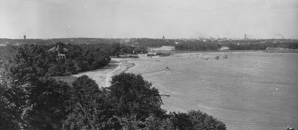
Lake Calhoun’s northwest shore and Bath House in late 1910s, before a parkway existed on the west side of the lake, although there is a light-colored trail or path. The north beach was mostly man-made. Photo likely taken from near the Minikahda Club. (Minneapolis Park and Recreation Board)
To my knowledge the dredging at Lake of the Isles and Cedar Lake produced little sand from those lake bottoms. Lake Harriet has never been dredged. It’s not obvious from any accounts I’ve seen of why “maka ska” or “white earth” was used to distinguish this lake from neighboring lakes in Cloud Man’s time or earlier.
Maybe a geologist could enlighten me. Were there relatively white deposits of sand in the vicinity at some point? What is the geological explanation? (For those of us who still believe in science anyway.) Were the shores of Lake Calhoun once sandy — before beaches, parkways and retaining walls?
If anyone can enlighten us about the Dakota language or can explain the park board’s garbled use of Bde Maka Ska, sometimes as a substitute for Lake Calhoun and others for Calhoun only, or can tell us about “white earth”, please do. I won’t post comments on whether we should keep or erase the Calhoun name; many other venues provide space for those arguments.
David C. Smith
Lake Calhoun Outlet and Lakewood Cemetery Greenhouses
Filed under: Lake Calhoun, Minneapolis Parks: General | Tags: Lake Calhoun, Lakewood Cemetery
Comments (10) I acquired this photograph because it’s the only one I’ve seen of an outlet from Lake Calhoun. But in light of today’s public tours of Lakewood Cemetery’s greenhouses I looked at the picture differently. Until I was told by Katie Thornton at Lakewood that the cemetery once had six huge greenhouses I had no idea what the buildings in this picture near the southeast shore of Lake Calhoun could be. Could they be the original Lakewood greenhouses?
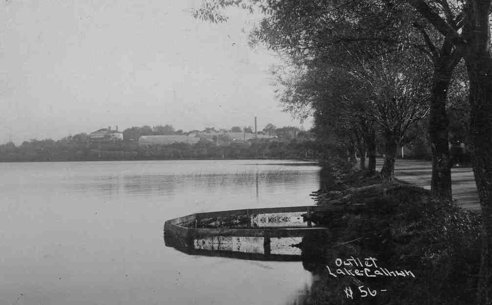
I don’t know the date of this photograph of the south shore of Lake Calhoun — or the photographer. I was interested in it primarily because of the “outlet” and the parkway running so close to the shore. But it may also be the only picture I’ve seen of the Lakewood Cemetery greenhouses. What else could that be near the southeastern shore of the lake? (Photo: David C. Smith Collection)
—
If you make it over to the Lakewood Cemetery greenhouse tour today and I don’t, please ask if their greenhouses are what we see here and let me know what you learn. If you have better information—or guesses—on what those structures might be, please share.
David C. Smith
100 Years Ago: Altered Electoral Map and Shorelines
Filed under: Grand Rounds, Minneapolis Golf Courses, Minneapolis Park Board, Minneapolis Parks: General, Mississippi River | Tags: Dr. Martin Luther King Park, Folwell Park, Lake Calhoun, Lake Nokomis, Phelps Park, St. Anthony Boulevard, Theodore Wirth
Comments (10) What has changed in 100 years? A few times on this site, I have looked back 100 years at park history. I’ll expand my scope this year because of extraordinary political developments. Politics first, then parks.
The national electoral map flipped. The electoral map of the 1916 Presidential contest is astonishing. Woodrow Wilson, a Democrat, won a close re-election against Republican candidate Charles Hughes, a Supreme Court Justice. Compare red and blue states below to today. Nearly inverted. The Northeast, Upper Midwest and Far West — well, Oregon — voted alike. Republican. And lost.

The 1916 electoral map was nearly opposite of the 2016 electoral map in terms of party preference. Unlike 2016, President Wilson won both the popular vote and the electoral vote, but his electoral-vote margin was smaller than Donald Trump’s. If the total of votes cast in 1916, fewer than 19 million, seems impossibly low even for the population at that time, keep in mind that only men could vote. (Source: Wikipedia)
While Minnesota’s electoral votes were cast for the Republican — although Hughes received only 392 more votes than Wilson out of nearly 400,000 cast — Minneapolis elected Thomas Van Lear as its mayor, the only Socialist to hold that office in city history. One hundred years later, Minneapolis politics are again dominated by left-of-center politicians.
The population of Minneapolis in 1916 and 2016 was about the same: now a little over 400,000, then a little under. Minneapolis population peaked in mid-500,000s in mid-1950s and dropped into mid-300,000s in late 20th Century. One hundred years ago, however, Minneapolis suburbs were very sparsely populated.
The world 100 years ago was a violent and unstable place. World War I was in its bloody, muddy depths, although the U.S. had not yet entered the war, and Russia was on the verge of revolution. Now people are killed indiscriminately by trucks, guns, and bombs. People worldwide debated then how to address the excesses of capitalists, oligarchs and despots unencumbered by morality. We still do.
One notable change? Many Americans campaigned in 1916 to put women in voting booths, in 2016 to put a woman in the Oval Office.
Continuing Park Growth: North and South
How about progress in parks? The Minneapolis park board added significantly to its playground holdings in 1916 and 1917 as public demand for facilities and fields for active recreation increased. In North Minneapolis, Glenwood (Theodore Wirth) Park was expanded and land for Folwell Park was acquired. In South Minneapolis, Nicollet (Rev. Dr. Martin Luther King, Jr.) Park and Chicago Avenue (Phelps) Park were purchased and land for Cedar Avenue Park was donated. In 1917, the first Longfellow Field was sold to Minneapolis Steel and steps were initiated to replace it at its present location.
One particular recreational activity was in park headlines in 1916 for the very first time. A nine-hole course was opened that year at Glenwood (Theodore Wirth) Park, the first public golf course in Minneapolis. Golf was free and greens weren’t green, they were made of sand. In less than ten years, the park board operated four 18-hole courses (Glenwood [Wirth], Columbia, Armour [Gross], and Meadowbrook) and was preparing to add a fifth at Lake Hiawatha.
The Grand Rounds were nearly completed conceptually, when first plans for St. Anthony Boulevard from Camden Bridge on the Mississippi River to the Ramsey County line on East Hennepin Avenue were presented in 1916. Park Superintendent Theodore Wirth also suggested that the banks of the Mississippi River above St. Anthony Falls might be made more attractive with shore parks and plantings, even if the railroads maintained ownership of the land. One hundred years later we’re still working on that, but have made some progress including the continuing purchase by the Park Board of riverfront lots as they have become available.These have been the only notable additions to park acreage in many years.
One important result of the increasing demand for playground space in Minneapolis one hundred years ago was the passage by the Minnesota legislature in 1917 of a bill that enabled the park board to increase property tax collections by 50%. In 2016, the Park Board and the City Council reached an important agreement on funding to maintain and improve neighborhood parks.
Altered Shorelines
In a city blessed with water and public waterfronts, however, some of the most significant issues facing the Minneapolis park board in 1917 involved shorelines — beyond beautifying polluted river banks.
The most contentious issue was an extension of Lake Calhoun, a South Bay, south on Xerxes Avenue to 43rd Street. Residents of southwest Minneapolis wanted that marshy area either filled or dredged — dry land or lake. There was no parkway at that time around the west and south shore of Lake Calhoun from Lake Street and Dean Parkway to William Berry Parkway. As a part of plans to construct a parkway along that shoreline, the park board in 1916 approved extending Lake Calhoun and putting a drive around a new South Bay as well.
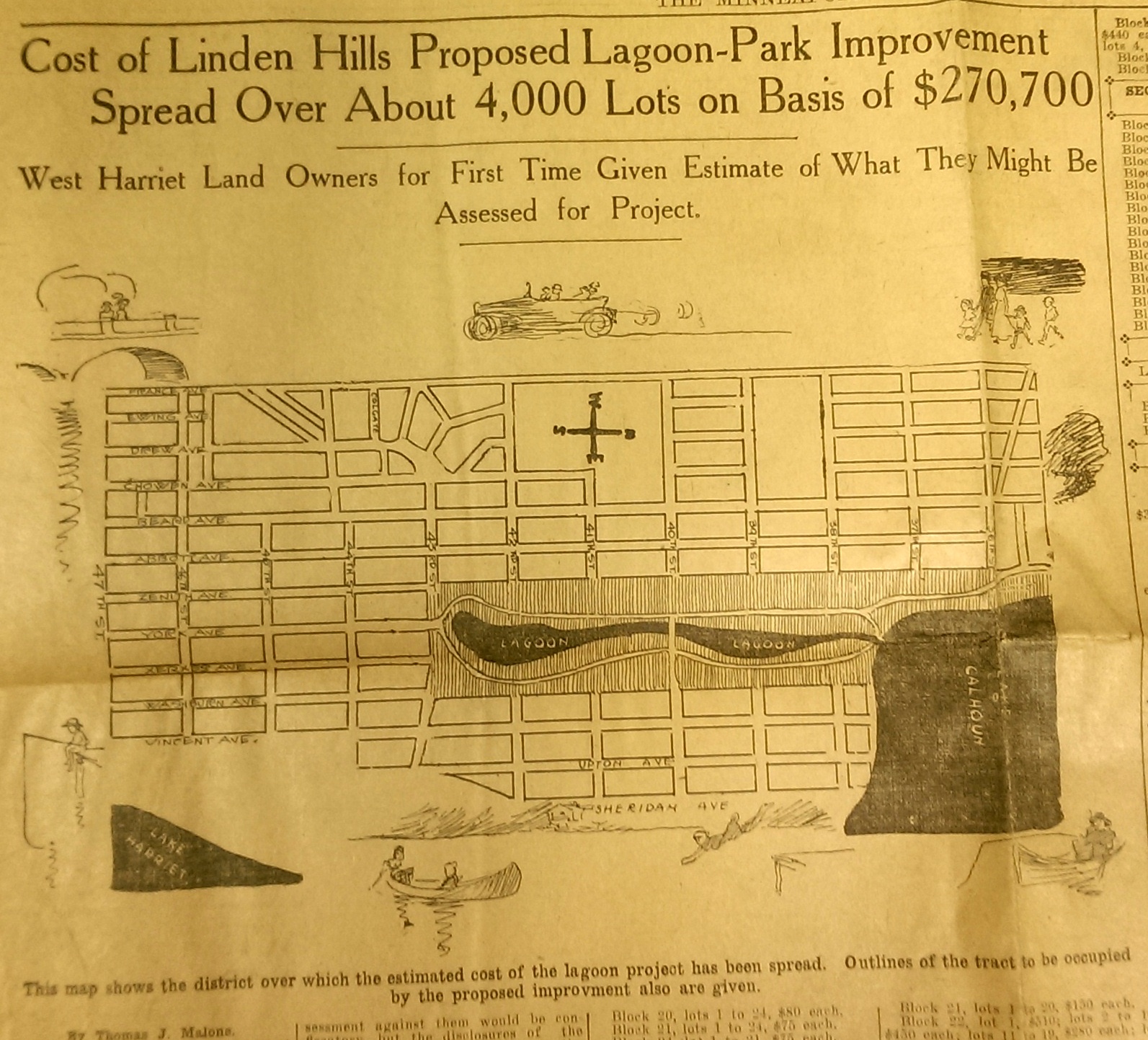
This drawing from a 1915 newspaper article shows the initial concept of a South Bay and outlines how it would be paid for. (Source: Minneapolis Sunday Tribune, June 20, 1915)
The challenge, of course was how to pay for it. The park board’s plan to assess property owners in the area for the expensive improvements was met with furiuos opposition and lawsuits. Many property owners thought that assessments they were already paying for acquisitions and improvements over the years at Lake Calhoun, Lake Harriet and William Berry Park were too heavy. The courts eventually decided in favor of the park board’s right to assess for those improvements, but by then estimated costs for the project had increased and become prohibitive and the South Bay scheme was abandoned.
Instead land for Linden Hills Park was acquired in 1919 and the surrounding wet land was drained into Lake Calhoun in the early 1920s. Dredged material from the lake was used to create a better-defined shoreline on the southwestern and northwestern shores of the lake in 1923 in preparation for the construction of the parkway.
Flowage Rights on the Mississippi River and a Canal to Brownie Lake
Minneapolis parks also lost land to water in 1916. The federal government claimed 27.6 acres of land in the Mississippi River gorge for flowage rights for the reservoir that would be created by a new dam to be built near Minnehaha Creek. Those acres, on the banks of the river and several islands in the river, would be submerged behind what became Lock and Dam No. 1 or the Ford Dam. In exchange for the land to be flooded, the park board did acquire some additional land on the bluffs overlooking the dam.
The other alteration in water courses was the dredging of a navigable channel between Cedar Lake and Brownie Lake, which completed the “linking of the lakes” that was begun with the connection of Lake of the Isles and Lake Calhoun in 1911. The land lost to the channel was negligible and probably balanced by a slight drop in water level in Brownie Lake. (A five-foot drop in Cedar Lake was caused by the opening of the Kenilworth Lagoon to Lake of the Isles in 1913.)
Another potential loss of water from Minneapolis parks may have occurred in 1917. William Washburn’s Fair Oaks estate at one time had a pond. I don’t know when that pond was filled. The estate became park board property upon the death of Mrs. Washburn in 1915. Perhaps in 1917 when the stables and greenhouses on the southwest corner of the property were demolished, the south end of the estate was graded and the pond was filled. Theodore Wirth’s suggestion for the park, presented in 1917, included an amphitheater in part of the park where the pond had once been.
The Dredge Report
The year 1917 marked the end of the most ambitious dredging project in Minneapolis parks — in fact the biggest single project ever undertaken by the park board until then, according to Theodore Wirth. The four-year project moved more than 2.5 million cubic yards of earth and reduced the lake from 300 shallow acres to 200 acres with a uniform depth of 15 feet.
That wasn’t the end of work at Lake Nokomis, however. The park surrounding the lake, especially the playing fields northwest of the lake couldn’t be graded for another five years, after the dredge fill had settled.
Dredging may again be an issue in 2017 if the Park Board succeeds in raising funds for a new park on the river in northeast Minneapolis. Dredges would carve a new island out of land where an old man-made island once existed next to the Plymouth Avenue Bridge. But that may be a long time off — and could go the way of South Bay.
Park Buzz
One other development in 1917 had more to do with standing water than was probably understood at the time. The Park Board joined with the Real Estate Board in a war on mosquitoes. However, after spending $100 on the project and realizing they would have to spend considerably more to achieve results, park commissioners terminated the project. It was not the first or last battle won by mosquitoes in Minneapolis.
As we look again at new calendars, it’s always worth taking a glance backward to see how we got here. For me, it is much easier to follow the course of events in Minneapolis park history than in American political history.
David C. Smith
Comments: I am not interested in comments of a partisan political nature here, so save those for your favorite political sites.
Where’s Waldo? Minnesota, Lair of Giants!
Filed under: Minneapolis Parks: General | Tags: H.W.S. Cleveland, Henry David Thoreau, Horace Cleveland, Lake Calhoun, Minneapolis, Ralph Waldo Emerson
Comments (4) I was researching other things last spring when I found two letters written by Ralph Waldo Emerson to his daughter Ellen from Minnesota in 1867—150 years ago this month.
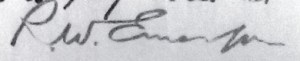
Emerson’s signature on his letter to his daughter Ellen in Concord, Massachusetts, January 31, 1867. (Emerson Family Correspondence, ca. 1725-1900 (MS Am 1280.226) Houghton Library, Harvard University.)
Emerson was on one of his annual lecture tours to the West, but it was his first venture across the Mississippi River into Minnesota.
He seemed to like the place—even commenting in his letter that Minneapolis was “said to be of admirable climate.” Perhaps he was not willing to trust his own judgment on the matter as he was visiting in January and in an account of his visit published in Minnesota History, June 1930, Hubert H. Hoeltje wrote that Emerson travelled from LaCrosse to Winona in an open carriage on a day that the temperature tumbled to 20 below zero. Emerson was kind enough not to frighten his daughter with accounts in his letters of such extreme hardship.
Emerson likely knew something of Minnesota from his old friend Henry David Thoreau who had visited Minneapolis, residing for a time on the shore of Lake Calhoun, in 1861. We also learn from the letters that he had cousins here. And Hoeltje observes in his article that Emerson had purchased property in Wisconsin in 1856.
Despite these connections and a history of lecturing in other not-quite-so-exotic locales since 1852 when he first lectured in St. Louis, Emerson reassured his daughter in his January 31 letter from Faribault that he was “in good new country with plenty of robust people who take kind care of me.” Still he felt it “a little pathetic” that people “born to be delicate and petted” had “removed into this rough yeomanly lair of the giants.”
Writing from St. Paul the next day he recounted for Ellen his meeting with his cousin Hannah Ladd Meyer and her children who lived in Northfield. Hannah, he wrote, “was as good & almost as handsome as in her youth.”
Emerson also recounted that his host in Faribault, grandson of the founder of the eponymous city, had taken him to visit eight “Sioux tepis (conical tents)” near town. He noted that the small village included only older men, women and children as the warriors had been “removed to Nebraska.” With Faribault, who “spoke Indian”, Emerson had visited the tents and in one had listened to two girls sing “quite prettily.” He also wrote that young Faribault, who was three-quarters Indian himself, had gone to school in Montreal and “was as handsome & as accurately dressed and did the honors as gracefully…as any youth from New York could be or do.” Emerson was disappointed that light in the tepis was provided not by burning pine-knots or birchbark, but by kerosene lamps. “I inquired,” he concluded, “whether I could see such another Indian picture between that spot and Boston and I was assured I could not.”
From Faribault, Emerson travelled to St. Paul, which he called a “proud, new, thriving town” of 12-15,000 people with handsome buildings and fine banks. Escorted by Governor William Marshall, he visited the State Capitol, but seemed most struck by the fact that Gov. Marshall was Swedenborgian by religion, a subject on which they conversed.
I do not wish to sow seeds of strife in these troubled times, but I am only here as a chronicler, and am compelled to cite Emerson’s comparison of my present home with my boyhood home.
“Thence to Minneapolis,” Emerson wrote two days later from there, “a town of greatest promise in all the northwest…If Edward [his son, recently graduated from Harvard] were to come west, let him come here. It is the house, St. Paul being only the front door.”
Emerson was not left alone much on his visit. His travelling companion from Faribault to St. Paul was Wisconsin Congressman and future governor, and famous miller, C.C. Washburn, and he ate Sunday dinner in Minneapolis with C.C.’s younger brother and future Minnesota Senator, William Drew Washburn. That day he also visited another cousin, Phebe Chamberlain, whom he had not seen in 30 years.
While in Minneapolis, Emerson lectured twice, once for the Athenaeum Library Association at Harrison Hall and again at the Universalist Church at 4th Ave. South and 5th St. Hubert Hoeltje noted that the only local newspaper coverage of the first Minneapolis lecture cited the time and place and a “large and attentive audience,” but concluded, “lack of space forbids comment.” A newspaper account of Emerson’s second lecture ended with the observation, “So great was the rush of people that scores were unable to obtain admission—among whom was the writer.” That struck me as one of the funniest things I’ve ever read in a newspaper.
As popular as Emerson was, he was not the biggest draw for the lecture series that year. Hoeltje reports, for instance, that Frederick Douglass drew an audience to St. Paul twice as large as Emerson’s. Perhaps Emerson’s star had faded somewhat by then. He had been lecturing for many years and was 63 years old, nearing the end of his lecturing career.
Emerson had nothing to do with Minneapolis parks apart from any influence his philosophy may have had on H. W. S. Cleveland’s view of nature and preservation of natural features of the landscape, especially in cities. Cleveland and his partner at the time, Robert Morris Copeland, had designed Sleepy Hollow Cemetery in Emerson’s hometown of Concord, Mass. in 1855. Emerson was on the committee that commissioned their work and gave the address at the dedication of the cemetery. He was also buried there—along with Thoreau, Nathaniel Hawthorne, and Louisa Mae Alcott. Cleveland and Emerson certainly knew each other. Cleveland scholar Daniel Nadenicek considers Emerson an important influence on Cleveland’s aesthetic. While there are similarities between the two men’s views, the more I have learned of Cleveland’s life, the less weight I have come to place on Emerson’s influence on Cleveland. But that’s probably subject matter for a book one of these days.
For now suffice to say that the frontier city of the northwest that held significant appeal for Emerson in 1867, was also the city in which Cleveland chose to live years later—and beautify with his vision, however it was shaped.
David C. Smith
© 2017 David C. Smith
Thanks Barbara MacLeish for correcting the date Thoreau lived at Lake Calhoun: 1861, not 1860. Corrections are always appreciated.
Charles Loring: “We must control the lake.”
Filed under: Loring Park, Minneapolis Lakes, Minneapolis parks | Tags: Charles M. Loring, Florence Barton Loring, Lake Calhoun, Lake Harriet, Lake of the Isles, Minneapolis parks, Minnehaha Falls
Comments (3) If you have read my history of the Minneapolis park system, City of Parks, you may recall that Charles Loring’s efforts to acquire land around lakes Harriet, Isles and Calhoun remain a subject of speculation. No one has ever found a clear strategy or well-documented plan by Loring, the first president of the Minneapolis Board of Park Commissioners, to acquire the lakes, even though he spent the better part of several years in getting those complicated real estate deals done. I focused mostly on Loring’s desire to create a parkway from Loring Park, then still called Central Park, around the lakes to Lake Harriet, which had been acquired already for the fledgling park board largely by gift. Even the generous gift of land around Lake Harriet by Henry Beard, James Merritt, Charles Reeve and, ultimately, William King, was prompted by the desire to have a parkway around the lake, which accounts for the limits of the original gift: a strip of land only 125 feet wide around Lake Harriet—just enough for a walking path, a carriage way and a few trees or flowers to dress it up.
A new discovery suggests, however, that Loring had much more in mind than parkways. As part of the ongoing project to inventory the park board’s historical records with the goal of making them more accessible to researchers, I recently found a letter written by Loring in 1886 that sheds more light on his thinking about the lakes.
The letter, dated June 14, 1886 and addressed to park board secretary Rufus Baldwin, discusses Loring’s views on what needs to be done to acquire land at Lake of the Isles. Loring notes that Alfred Dean, who owned much of the land that had to be crossed by a parkway at Lake of the Isles, had already told Loring he could do whatever he wished. Loring then wrote,
“My opinion is that we do not want the land on the outside, but do want it next the lake. As the plat now is, the boulevard goes around the little marsh thus.”
Loring then includes a small drawing.
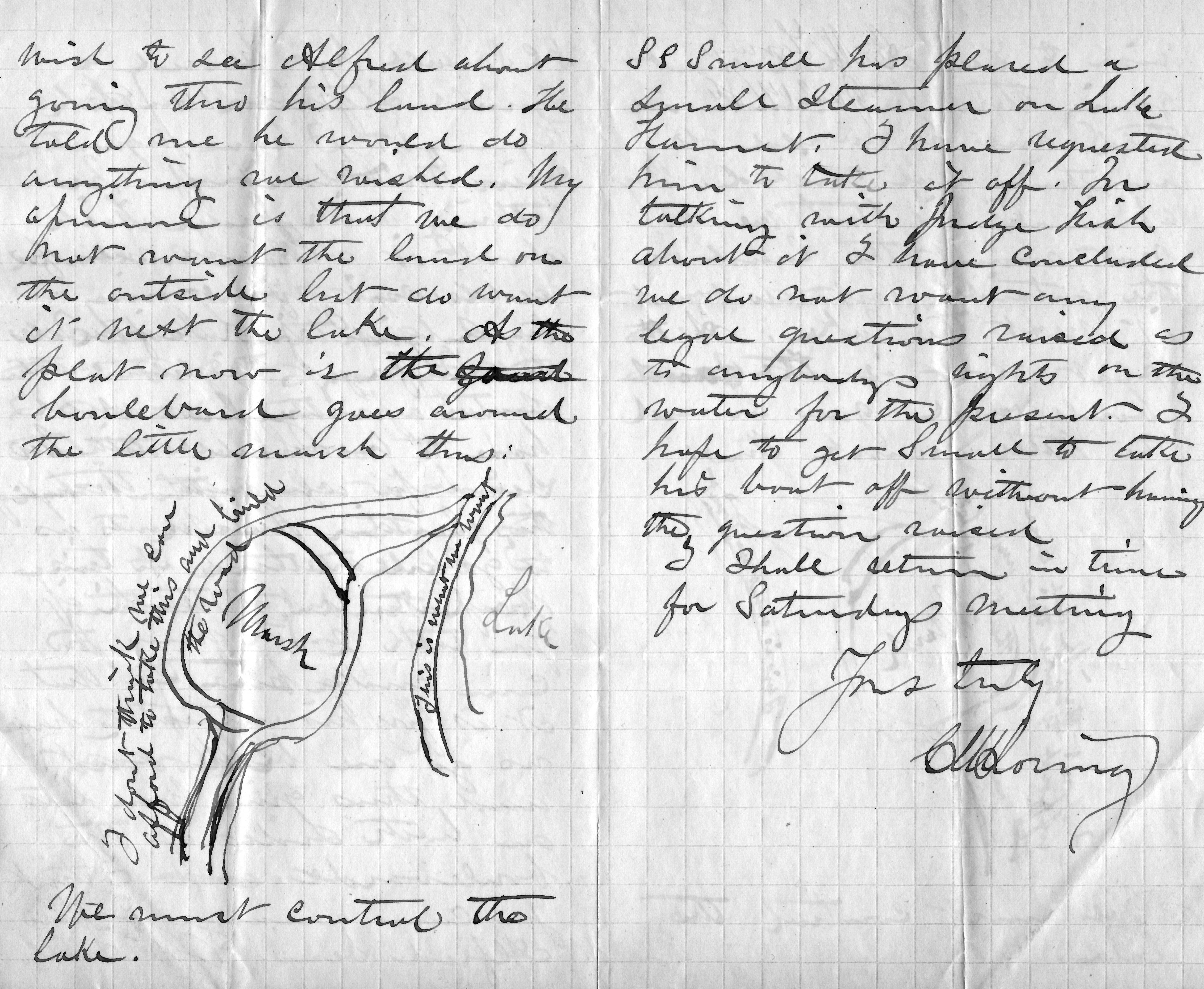
Charles Loring’s letter to Rufus Baldwin, June 14, 1886
He is very explicit, writing on the road next to the lake “This is what we want” and concluding bluntly, “We must control the lake.”
This evidence that Loring was thinking far beyond parkways is reinforced by the concluding page of his letter when he addresses a new topic: boats on Lake Harriet. He notes that a steamer has been placed on the lake and he has asked the owner to remove it, but adds that after talking with “Judge Fish”—park board attorney Daniel Fish—Loring doesn’t want legal questions raised yet about “rights on the water”. Clearly, Loring is thinking about park board control not just of boulevards around the lake, but activity on the lake as well. His earlier comment, “We must control the lake”, takes on even greater significance.
We may owe even more to Charles Loring and his vision than we previously knew.
While on the subject of Loring I want to mention a note I received a while ago from, William Scott, the great-great-nephew of Charles Loring’s second wife Florence Barton Loring. You can read more about his family’s relationship with the Bartons and Lorings in the “Comments” section here.
This is the carte de visite of Florence Barton that he refers to. Thanks to William Scott for sharing the photos below.

Florence Barton, date unknown. (Beal Art Gallery, Harold W. Scott Collection, courtesy William Scott)
This must have been taken long before she married Charles Loring at age 45 in 1895. Read much more about Florence Barton Loring here.
William Scott also sent a photograph of family and friends at Minnehaha Falls in about 1910. Love those hats! The new bridge with the boulder face over a concrete structure was brand new in 1910. Appears to be a dry year.

David C. Smith
© 2016 David C. Smith
1911 Minneapolis Civic Celebration: Junk Mail
Filed under: Minneapolis Lakes, Minneapolis Park Board, Minneapolis parks | Tags: 1911 Minneapolis Civic Celebration, Cedar Lake, Chain of Lakes, Kenilworth Lagoon, Lake Calhoun, Lake of the Isles, Southwest LRT
Leave a comment I have neglected these pages in recent months, yet I have so many good park stories to tell, some of them from readers. I will get to them soon I hope. In the last eight months I have discovered more fascinating information about Minneapolis parks and the people who created them than at any time since my initial research for City of Parks. But until I can get to those stories, I wanted to show you one of the more interesting bits of history I’ve encountered recently. Garish, but oddly charming.
The images below are of a promotional envelope used by a Minneapolis merchant in advance of the July 1911 Civic Celebration that was conceived primarily to celebrate the digging of the channel that connected Lake Calhoun with Lake of the Isles — as is noted at the bottom of the envelope. I found these images on an Ebay auction site and use them with permission of the seller of the envelope who sells mostly postal history under the name of “gregfree”. This envelope is for sale at an opening bid of $150 — more than I can pay. I appreciate gregfree’s willingness to let me share the image with you. Maybe you should buy it. If you do, thank him for me.

A promotional envelope used by a Minneapolis merchant. One of the objectives of the Civic Celebration was to give businesses an opportunity to contact, perhaps entertain and certainly solicit business from their clients throughout the region.
I love the background in green, a photo of the Stone Arch Bridge and Mill District, laid over a map of the city that shows the Chain of Lakes and Minnehaha Creek meeting the Mississippi River in the lower right corner.

The back of the envelope is an advertisement for Minneapolis, and from my perspective the lede is not buried — “Public Park System Unequalled.” That puts the emphasis exactly where it should be!
It’s nice to know that Minneapolis also had the lowest death rate in the United States. How that was measured, I’m not sure.
The coincidence of me finding this image now has a bit of Ouija-Board spookiness to it, because the lake connections have been on my mind — and in the news — a good bit lately. The channel that was celebrated 103 years ago between Isles and Calhoun has been in the news because the developer of a residential building at Knox Avenue and Lake Street has been pumping millions of gallons of water from a flooded underground parking garage into that channel, which has prevented it from freezing and caused considerable increase in phosphorous levels in the lake. More phosphorous means more algae. The Park Board and the City have sued to stop the pumping. Good! Such negligence on the part of a developer is astonishing. Hmmm, what do you think might happen if you put a parking garage below the water table between two lakes? I’m no engineer, but I think I’d be a tad suspicious of anyone who told me, “Hey, no problem.” The next time you hear people complaining about too much government regulation, ask them if it’s cases like this that they have in mind? I hope the Park Board uses every weapon at their disposal in this case to protect our lakes.
The other lake connection issue is not so clear-cut, but may be more important. That is the issue of tunneling under or bridging over the Kenilworth Lagoon that connects Lake of the Isles and Cedar Lake in order to build the Southwest LRT.
The history of other interests, public and private, wanting to take a little park land here or there for this or that good idea is long and sordid. For decades the park board has had to fight those who wanted just an acre or a little easement across park property. If the Park Board had acquiesced, all we’d have left of a magnificent park system would be a couple triangle parks. The reasons for taking park land have often been legitimate. For instance, I’m strongly in favor of better mass transit in Minneapolis and the entire Twin Cities metro area, but only if it doesn’t harm parks — or even the notion of parks. Is a tunnel or a bridge over Kenilworth channel better for the LRT? That question and a hornets nest of others, isn’t the right place to start. The only place to start in my very prejudiced opinion is with “Will it harm park property?” If the Park Board determines that the answer to that question is “Yes,” it is obliged to oppose those plans with all its might — regardless of how small the “harm.” Because in historical terms, “harm” seems more than precedent, it is invitation.
I have more to write about the issue. Did you know that the Park Board once went to the United States Supreme Court to prevent the State of Minnesota from taking Minneapolis parkland? True story. Til then quite an interesting envelope. Thanks again gregfree.
David C. Smith
© 2014 David C. Smith
Approaching Lake Calhoun — A Couple Years Later
Filed under: Minneapolis Parks: General | Tags: Dean Parkway, Lake Calhoun
Comments (5) Julieann Swanson, Assistant Curator of Digital Collections and Archives at the University of Minnesota’s College of Design just sent a fabulous photo of the Lake Street, Dean Parkway, and West Calhoun Parkway intersection from about 1956 in response to my post earlier today. See Julieann’s comments on that post for more information on this photo and the Digital Content Library.
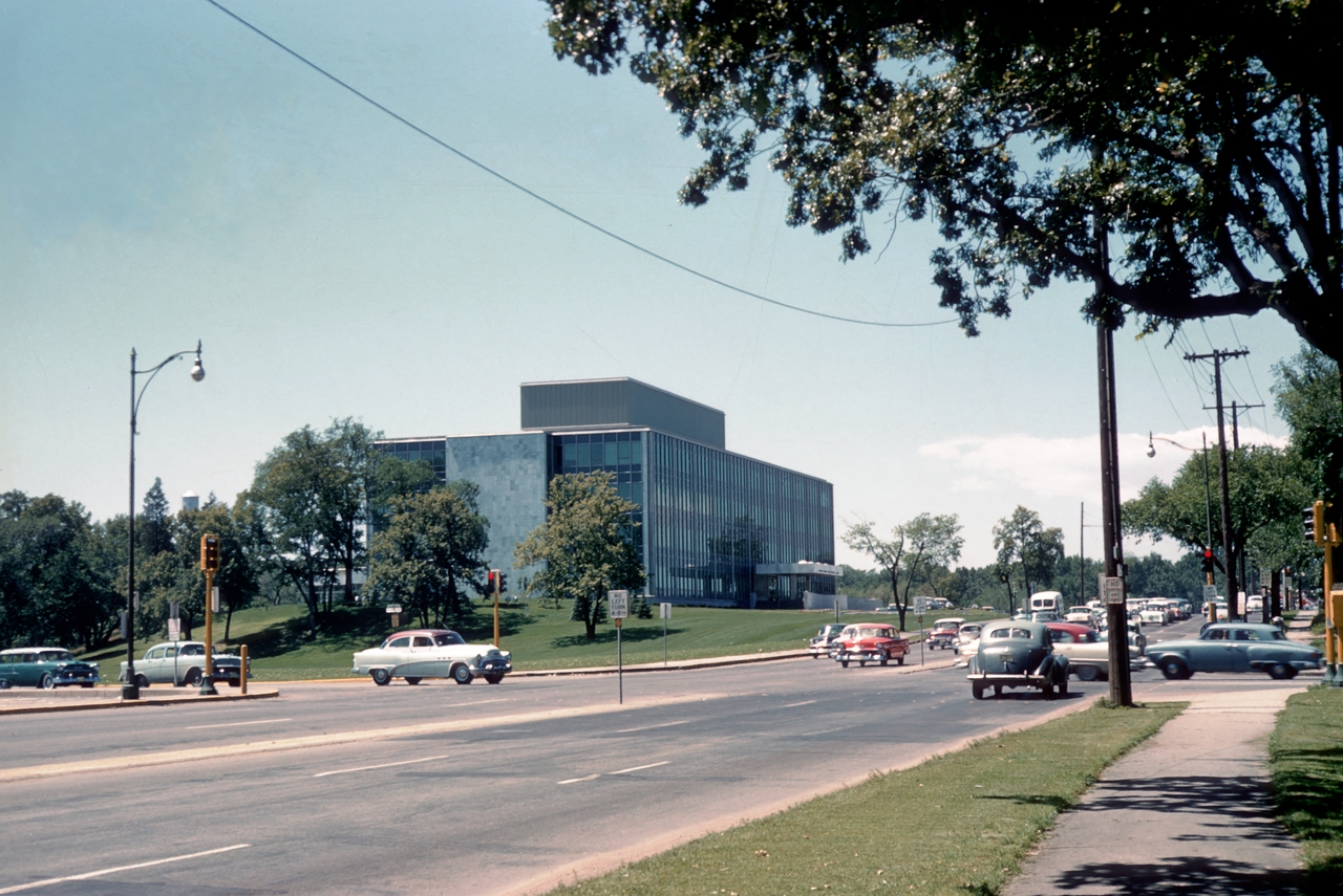
Looking west on Lake Street toward the intersection with Dean Parkway and West Calhoun Parkway. (Photo: University of Minnesota, Digital Content Library)
Julieann suggested that the photo is circa 1955, but I’ve advanced it a year to 1956, because I believe that is a red 1956 Chevy sitting at the east-bound stop light. And, yes, the traffic lights are quite visible in this photo! Would that car have been called, “Cherry”? I’m a little too young to remember ’50s slang.
Thanks, Julieann.
David C. Smith
© 2013 David C. Smith
Approaching Lake Calhoun
Filed under: Minneapolis Parks: General | Tags: Dean Parkway, Lake Calhoun, William Berry Parkway
Comments (7) Two photos from the 1950s, and two that are much older, show how people got to Lake Calhoun once upon a time. Both photos are from the Minnesota Historical Society’s online collection. I haven’t written about that collection in some time, but I continue to use it extensively for research on Minneapolis parks and other historical subjects. You should take a look if you haven’t before. It’s a treasure.
The first photo shows the intersection of Lake Street, Dean Parkway and West Calhoun Parkway, looking west.
Many Minneapolis parkways were once called “boulevards”, but that changed in 1968 when the Minneapolis park board renamed nearly all of them “parkways.” The park board wanted to create uniformity in treatment, but also believed that by calling them parkways, people would better understand that they were owned by the park board and were part of the park system. I still refer to them as boulevards at times, out of habit, as do many others. Curiously, Google maps hedges, labelling the road around the west side of Lake Calhoun “W Calhoun Pkwy” and “Calhoun Blvd”.
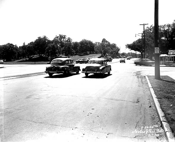
Travelling west on Lake St. at Dean Parkway. West Calhoun parkway begins at far left. (Norton and Peel, Minnesota Historical Society)
Note that the lot on the southwest corner of the intersection (upper left) is still undeveloped in 1953.
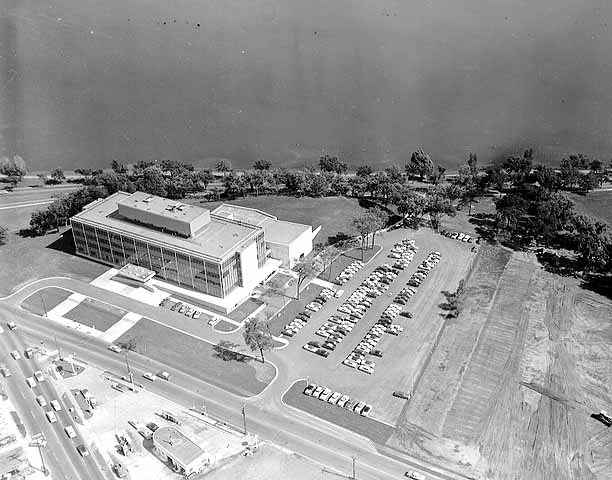
Aerial view, 1956. Excelsior Blvd. is in the foreground. Minnesota Historical Society)
The earliest photos I’ve found of the American Hardware Mutual Insurance Company building on the site are dated 1956, such as this aerial photo from the Minneapolis Star Journal Tribune.
The park board never owned that piece of land, although it would have been a good addition to the lake park. The park board reported in 1916 that the purchase of 93 acres on that corner was pending, but the deal never was completed. The land behind the building to the southwest was once a small bay of the lake, which the park board filled with material dredged from the lake bottom.
Perhaps it’s simply an issue of the resolution of this photo, but I don’t see traffic lights even though it appears that east- and west-bound traffic is stopped. The lights must have been installed about this time, because the city engineer had developed an initial plan for lights at this increasingly busy intersection in 1951.
The photo below was taken at the opposite, or southeastern, corner of Lake Calhoun at about the same time.

36th Street approaching the southeastern corner of Lake Calhoun, 1955. Lakewood Cemetery is on the left. (Norton and Peel, Minnesota Historical Society)
The photo is notable especially because the foundation of the street railway bridge over 36th Street still stands. This was the location of the rails that went to Lake Harriet and beyond to Excelsior and Lake Minnetonka. Of course, there were no traffic lights at the intersection of 36th and East Calhoun Parkway either.

East Calhoun Parkway in about 1890. Looking north from Lakewood Cemetery.(Minnesota Historical Society)
The trestle had been there since before the park board built the parkway. (See more on the Lyndale Railway Company at Lake Calhoun and Lake Harriet.) In the photo at right you can see the bridge foundation (far right), in front of the carriage turning east onto 36th Street. The fountain in the boulevard for watering horses was an interesting touch. So was the scalloped hedge between the parkway and the lake. Does anyone know when the street railway bridge supports were torn down?
Most of the earliest parkways around lakes ran right along the water’s edge. That feature of early parkways is more prominent in the photo below of the end of Calhoun Parkway in about 1905. At that time the parkway ended where it turned south to connect to Lake Harriet. The land behind the photographer in this photo was private land all the way around the west shore of the lake back to Lake Street and the top photo.

The end of Calhoun Parkway at the south end of Lake Calhoun in 1905. The road turned to the right, the future William Berry Parkway, connecting to Lake Harriet. (Minnesota Historical Society)
The photo below shows the approach to the north end of Lake Calhoun from about the same time period as the photo above.

The north shore of Lake Calhoun from Lake Street, facing west in about 1902. (Minnesota Historical Society)
This photo shows Lake Street facing west at the northeast corner of Lake Calhoun. This was before the park board acquired the north shore of the lake. The only park land around the lake at this time was Calhoun Parkway beginning at the left of this photo and continuing to the previous photo.
David C. Smith

