Archive for the ‘Lake Nokomis’ Tag
100 Years Ago: Altered Electoral Map and Shorelines
Filed under: Grand Rounds, Minneapolis Golf Courses, Minneapolis Park Board, Minneapolis Parks: General, Mississippi River | Tags: Dr. Martin Luther King Park, Folwell Park, Lake Calhoun, Lake Nokomis, Phelps Park, St. Anthony Boulevard, Theodore Wirth
 Comments (10)
 What has changed in 100 years? A few times on this site, I have looked back 100 years at park history. I’ll expand my scope this year because of extraordinary political developments. Politics first, then parks.
The national electoral map flipped. The electoral map of the 1916 Presidential contest is astonishing. Woodrow Wilson, a Democrat, won a close re-election against Republican candidate Charles Hughes, a Supreme Court Justice. Compare red and blue states below to today. Nearly inverted. The Northeast, Upper Midwest and Far West — well, Oregon — voted alike. Republican. And lost.

The 1916 electoral map was nearly opposite of the 2016 electoral map in terms of party preference. Unlike 2016, President Wilson won both the popular vote and the electoral vote, but his electoral-vote margin was smaller than Donald Trump’s. If the total of votes cast in 1916, fewer than 19 million, seems impossibly low even for the population at that time, keep in mind that only men could vote. (Source: Wikipedia)
While Minnesota’s electoral votes were cast for the Republican — although Hughes received only 392 more votes than Wilson out of nearly 400,000 cast — Minneapolis elected Thomas Van Lear as its mayor, the only Socialist to hold that office in city history. One hundred years later, Minneapolis politics are again dominated by left-of-center politicians.
The population of Minneapolis in 1916 and 2016 was about the same: now a little over 400,000, then a little under. Minneapolis population peaked in mid-500,000s in mid-1950s and dropped into mid-300,000s in late 20th Century. One hundred years ago, however, Minneapolis suburbs were very sparsely populated.
The world 100 years ago was a violent and unstable place. World War I was in its bloody, muddy depths, although the U.S. had not yet entered the war, and Russia was on the verge of revolution. Now people are killed indiscriminately by trucks, guns, and bombs. People worldwide debated then how to address the excesses of capitalists, oligarchs and despots unencumbered by morality. We still do.
One notable change? Many Americans campaigned in 1916 to put women in voting booths, in 2016 to put a woman in the Oval Office.
Continuing Park Growth: North and South
How about progress in parks? The Minneapolis park board added significantly to its playground holdings in 1916 and 1917 as public demand for facilities and fields for active recreation increased. In North Minneapolis, Glenwood (Theodore Wirth) Park was expanded and land for Folwell Park was acquired. In South Minneapolis, Nicollet (Rev. Dr. Martin Luther King, Jr.) Park and Chicago Avenue (Phelps) Park were purchased and land for Cedar Avenue Park was donated. In 1917, the first Longfellow Field was sold to Minneapolis Steel and steps were initiated to replace it at its present location.
One particular recreational activity was in park headlines in 1916 for the very first time. A nine-hole course was opened that year at Glenwood (Theodore Wirth) Park, the first public golf course in Minneapolis. Golf was free and greens weren’t green, they were made of sand. In less than ten years, the park board operated four 18-hole courses (Glenwood [Wirth], Columbia, Armour [Gross], and Meadowbrook) and was preparing to add a fifth at Lake Hiawatha.
The Grand Rounds were nearly completed conceptually, when first plans for St. Anthony Boulevard from Camden Bridge on the Mississippi River to the Ramsey County line on East Hennepin Avenue were presented in 1916. Park Superintendent Theodore Wirth also suggested that the banks of the Mississippi River above St. Anthony Falls might be made more attractive with shore parks and plantings, even if the railroads maintained ownership of the land. One hundred years later we’re still working on that, but have made some progress including the continuing purchase by the Park Board of riverfront lots as they have become available.These have been the only notable additions to park acreage in many years.
One important result of the increasing demand for playground space in Minneapolis one hundred years ago was the passage by the Minnesota legislature in 1917 of a bill that enabled the park board to increase property tax collections by 50%. In 2016, the Park Board and the City Council reached an important agreement on funding to maintain and improve neighborhood parks.
Altered Shorelines
In a city blessed with water and public waterfronts, however, some of the most significant issues facing the Minneapolis park board in 1917 involved shorelines — beyond beautifying polluted river banks.
The most contentious issue was an extension of Lake Calhoun, a South Bay, south on Xerxes Avenue to 43rd Street. Residents of southwest Minneapolis wanted that marshy area either filled or dredged — dry land or lake. There was no parkway at that time around the west and south shore of Lake Calhoun from Lake Street and Dean Parkway to William Berry Parkway. As a part of plans to construct a parkway along that shoreline, the park board in 1916 approved extending Lake Calhoun and putting a drive around a new South Bay as well.
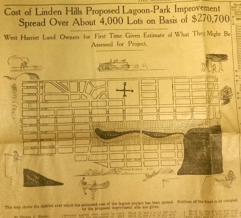
This drawing from a 1915 newspaper article shows the initial concept of a South Bay and outlines how it would be paid for. (Source: Minneapolis Sunday Tribune, June 20, 1915)
The challenge, of course was how to pay for it. The park board’s plan to assess property owners in the area for the expensive improvements was met with furiuos opposition and lawsuits. Many property owners thought that assessments they were already paying for acquisitions and improvements over the years at Lake Calhoun, Lake Harriet and William Berry Park were too heavy. The courts eventually decided in favor of the park board’s right to assess for those improvements, but by then estimated costs for the project had increased and become prohibitive and the South Bay scheme was abandoned.
Instead land for Linden Hills Park was acquired in 1919 and the surrounding wet land was drained into Lake Calhoun in the early 1920s. Dredged material from the lake was used to create a better-defined shoreline on the southwestern and northwestern shores of the lake in 1923 in preparation for the construction of the parkway.
Flowage Rights on the Mississippi River and a Canal to Brownie Lake
Minneapolis parks also lost land to water in 1916. The federal government claimed 27.6 acres of land in the Mississippi River gorge for flowage rights for the reservoir that would be created by a new dam to be built near Minnehaha Creek. Those acres, on the banks of the river and several islands in the river, would be submerged behind what became Lock and Dam No. 1 or the Ford Dam. In exchange for the land to be flooded, the park board did acquire some additional land on the bluffs overlooking the dam.
The other alteration in water courses was the dredging of a navigable channel between Cedar Lake and Brownie Lake, which completed the “linking of the lakes” that was begun with the connection of Lake of the Isles and Lake Calhoun in 1911. The land lost to the channel was negligible and probably balanced by a slight drop in water level in Brownie Lake. (A five-foot drop in Cedar Lake was caused by the opening of the Kenilworth Lagoon to Lake of the Isles in 1913.)
Another potential loss of water from Minneapolis parks may have occurred in 1917. William Washburn’s Fair Oaks estate at one time had a pond. I don’t know when that pond was filled. The estate became park board property upon the death of Mrs. Washburn in 1915. Perhaps in 1917 when the stables and greenhouses on the southwest corner of the property were demolished, the south end of the estate was graded and the pond was filled. Theodore Wirth’s suggestion for the park, presented in 1917, included an amphitheater in part of the park where the pond had once been.
The Dredge Report
The year 1917 marked the end of the most ambitious dredging project in Minneapolis parks — in fact the biggest single project ever undertaken by the park board until then, according to Theodore Wirth. The four-year project moved more than 2.5 million cubic yards of earth and reduced the lake from 300 shallow acres to 200 acres with a uniform depth of 15 feet.
That wasn’t the end of work at Lake Nokomis, however. The park surrounding the lake, especially the playing fields northwest of the lake couldn’t be graded for another five years, after the dredge fill had settled.
Dredging may again be an issue in 2017 if the Park Board succeeds in raising funds for a new park on the river in northeast Minneapolis. Dredges would carve a new island out of land where an old man-made island once existed next to the Plymouth Avenue Bridge. But that may be a long time off — and could go the way of South Bay.
Park Buzz
One other development in 1917 had more to do with standing water than was probably understood at the time. The Park Board joined with the Real Estate Board in a war on mosquitoes. However, after spending $100 on the project and realizing they would have to spend considerably more to achieve results, park commissioners terminated the project. It was not the first or last battle won by mosquitoes in Minneapolis.
As we look again at new calendars, it’s always worth taking a glance backward to see how we got here. For me, it is much easier to follow the course of events in Minneapolis park history than in American political history.
David C. Smith
Comments: I am not interested in comments of a partisan political nature here, so save those for your favorite political sites.
Lake Nokomis Bath House
One of my favorite pictures of Lake Nokomis. Construction of the bath house was completed in 1920, not long before this photo was taken. The barren landscape — on both sides of the lake — is surprising. (Click the image to enlarge.) This is one of many park board photos that may become available to the public in the near future through the Minnesota Digital Library.

The new playing fields and bath house at Lake Nokomis. Early 1920s. Taken from Cedar Avenue. (Minneapolis Park and Recreation Board.)
What became of that bath house? The Minneapolis Star ran the photo below on May 2, 1966. The building had been declared unsafe, but demolition was prompted by thousands of dollars of damage done by vandals that winter. Only the toilet rooms of the bath house were left standing for the summer of 1966. A new, smaller bath house was built the next summer. At the time it was the most heavily used beach in the city.

David C. Smith
The Worst Idea Ever #8: Power Boat Canal from Minnetonka to Harriet
Filed under: Minneapolis Lakes, Minneapolis Parks: General | Tags: 1911 Minneapolis Civic Celebration, Lake Harriet, Lake Hiawatha, Lake Minnetonka, Lake Nokomis, Minnehaha Creek, Minnehaha Falls
Comments (1) Ok, it wasn’t really a Minneapolis park project, but it still deserves a laugh: Minnehaha Creek converted into a 30-foot-wide power boat canal from Lake Minnetonka to Lake Harriet!

Lake Harriet could have been more like Lake Minnetonka.
Minneapolis was obsessed in the spring of 1911 with the upcoming Civic Celebration during which the channel between Lake Calhoun and Lake of the Isles would be opened. That was a very good thing. Huzzah, huzzah. But the attention it was drawing to the city also focused a lot of eyes on a very bad thing: Minnehaha Creek was nearly dry — in the spring! — which meant almost no water over Minnehaha Falls. Minneapolis could hardly celebrate the opening of the lake connection at the same time it suffered the ignominy of a dry Minnehaha Falls. The many out-of-town visitors anticipated for the celebration would surely want to see both. And let’s face it, a fifty-foot waterfall written about by a Harvard poet, which attracted visitors from around the world was a bit more impressive to most people than a short canal under a busy road and railroad tracks. The Minneapolis PR machine could call the city the “Venice of North America” all it wanted with its new canal, but visitors’ imaginations were still probably fueled more by the images of the famous poet’s noble heathen, beautiful maiden, and “laughing waters.”
The generally accepted solution to the lack of water over Minnehaha Falls was to divert Minnehaha Creek into Lake Amelia (Nokomis), drain Rice Lake (Hiawatha), dam the outlet of the creek from Amelia to create a reservoir, and release the impounded water as needed — perhaps 8 hours a day — to keep a pleasing flow over the falls. Unfortunately, with all the last-minute dredging and bridge-building for the Isles-Calhoun channel, that couldn’t be done in 1911 between April and July 4, when the Civic Celebration would launch.
Into this superheated environment of waterways and self-promotion stepped Albert Graber, according to the Saturday Evening Tribune, May 28, 1911. With the backing of “members of the board of county commissioners, capitalists, attorneys and real estate dealers”, Graber proposed to dredge Minnehaha Creek into a canal 30-feet wide from Lake Minnetonka to Lake Harriet. This would provide not only a water superhighway from Minnetonka to Minneapolis, and boost real estate prices along the creek, but it would also create a much larger water flow in Minnehaha Creek, solving the embarrassment of no laughing water.
“The plan, say the promoters, would enable residents of summer houses on the big lake to have their launches waiting at the town lake.”
Saturday Evening Tribune, May 28, 1911
Sure, there were problems. Not every plan could be perfect. The plan would require dismantling the dam at Gray’s Bay at the head of Minnehaha Creek, which might lower the level of Lake Minnetonka. But Graber and his backers had thought of that. The Minnesota River watershed in the area of St. Bonifacius and Waconia would be diverted into Lake Minnetonka — no problem! — which also solved another bother: it would reduce flooding on the Minnesota River.
The dam at Gray’s Bay had been operated by Hennepin Country since 1897. Many people then and now consider the dam the cause of low water flow in Minnehaha Creek, but the earliest reference I can find to low water in the creek was in 1820, when the soldiers of Fort Snelling wanted to open a mill on Minnehaha Creek, but were forced to move to St. Anthony Falls due to low water. That was even before two intrepid teenagers from the fort discovered that the creek flowed out of a pretty big lake to the west.
Graber estimated that dredging Minnehaha Creek would cost about $4,000 a mile for the nine miles between the two lakes. He and his backers, which included an officer of the Savings Bank of Minneapolis (who presumably had a summer house on the big lake and could put a launch on the town lake), provided assurances that the money to finance the project could be “readily found.”
The Evening Tribune article concluded with an announcement that meetings of those interested in the project would be held in the near future with an eye to beginning work before the end of the summer. Graber noted that his inspection of the project had been, no surprise, “superficial”, but that he would make a thorough report soon to his backers. I can find no evidence that the idea progressed any further.
The Board of Park Commissioners would have had no role in the plan, except, perhaps, allowing power boats to enter and be anchored on Lake Harriet. (I think they would have said no.) Park board ownership of Minnehaha Creek west of Lake Harriet to Edina wasn’t proposed until 1919 and the deal wasn’t done until 1930.
David C. Smith
© 2013 David C. Smith
Bombers Over Lake Nokomis
Filed under: Minneapolis Golf Courses, Minneapolis Lakes, Minneapolis parks | Tags: Hiawatha Golf Course, Lake Hiawatha, Lake Nokomis, Wold Chamberlain Field
Comments (2) My favorite photo of Lake Nokomis was taken in 1932. The true subject of the photo was a squadron of Martin bombers visiting Wold-Chamberlain Field from Langley Field, Virginia, but beneath them is a fascinating scene of park developments.

The Martin Bomber was the first American airplane built specifically to carry bombs. First built during WWI, the biplane version of the bomber was replaced by a monoplane version designed in 1932. (Minnesota Historical Society)
The photographer isn’t listed in the Minnesota Historical Society’s database, but it may have been taken by J. E. Quigley Aerial Photography. Quigley produced most of the other aerial photos of Minneapolis from that era.
The bare ground at the left wingtip of the middle plane is the Hiawatha Golf Course under construction. The course didn’t open until 1934. Dredging in Lake Hiawatha had just been completed in 1931.
It doesn’t show up well at this size, but the Nokomis Beach is packed (beneath the front airplane). You can see the diving towers in the lake.
Also note how barren the Nokomis lakeshore is. It had been created from lake dredgings only 15 years earlier.
Four years after dredging was completed at Lake Nokomis and the dredge fill had settled, the park board cleared and graded the land. (Minneapolis Park and Recreation Board)
The dredge fill settled for four years before it was cleared of brush and willows that had grown up in the intervening years and the land was graded for athletic fields. The huge piles of brush in the background were burned. Of course the land was graded by horse teams. Even with that much time for the dredge fill to settle before it was graded, the playing fields continued to settle and were re-graded in the 1930s as a WPA project.
Even after ten years of tree growth, the lake shore doesn’t look very shaded in the 1932 photo.
The Cedar Avenue Bridge at the bottom of the aerial photo was the subject of great debate at the park board, Minneapolis City Council, the Hennepin County Board and Village Council of Richfield in the 1910s. Park superintendent Theodore Wirth’s plan for the improvement of Lake Nokomis in the 1912 annual report included rerouting Cedar Avenue around the southwest corner of the lake to eliminate a “very unsightly” wooden bridge over the edge of lake at the time. Even though the park board owned all the shores of the lake and the lake bed, the south end of the lake was then in Richfield, which is why the county and Richfield were involved in decisions on the bridge. Despite the park board position that building a bridge would be more expensive and less attractive, it was built—and paid for with Minneapolis bond funds—partly due to opposition by Richfield landowners to plans to reroute Cedar. By 1926 that line of opposition would have been partially removed when Minneapolis annexed about a mile-wide strip of Richfield that placed all of Lake Nokomis inside Minneapolis city limits.
David C. Smith
Minneapolis Park Memory: A Wonderful Gift
Filed under: Minneapolis Park Memory | Tags: Columbia Park, Lake Calhoun, Lake Harriet, Lake Nokomis, Minneapolis parks, Minnehaha Creek, Powderhorn Park
Leave a comment About two years ago, when our son-in-law was in the North St. Paul Library, he saw David Smith’s book about Minneapolis parks. He bought one and gave it to me for Christmas. We have enjoyed reading it and looking at the pictures.
Jim became acquainted with Minnehaha Park and Parkway when he came to freshman orientation at Hamline in 1948. He particularly remembers the beauty of the lilac trees. When we lived in Rosemount, we came to Nokomis Park to picnic, swim and sail with friends. When we moved to Columbia Heights, Jim started to bike daily, and a few times each summer, he biked the Grand Rounds. We biked it with a church group a time or two. We continued to do that when we lived in Champlin and in north Minneapolis.
The house we owned since 1985 was near Lake Harriet and we biked around that lake and also Lake Calhoun and Lake of the Isles. We slid in the snow and watched our grandson’s rugby games at Columbia Park. We enjoyed many picnics near each of those lakes and the Rose Garden, Hiawatha, Nokomis, Farwell, Powderhorn and Wirth. Sometimes there were only two of us; other times it was a family gathering. We celebrated many birthdays and events by having picnics at a park. Following Thanksgiving dinner at our house, most of the guests enjoyed a walk around all or part of Lake Harriet. A recent memory is walking with our five-year-old granddaughter to a bridge over Minnehaha Creek and dropping sticks into the water and watching them float away. We are glad that our new home is near the Parkway, Minnehaha Park and Lake Nokomis, so we can continue to enjoy our wonderful gift of parks.
Phyllis Minehart
Minneapolis Park Memory: North to South
Filed under: Minneapolis Park Memory | Tags: Glenwood Park, Lake Hiawatha, Lake Nokomis, Minnehaha Falls, Victory Memorial Drive, Webber Pool
Comments (6) Minneapolis truly is a “City of Parks” for everyone — north, south, east , and west. As a ten-year-old tomboy in north Minneapolis, the neighbor kids and I would hike three miles to Glenwood Park, where we hunted for golf balls at the golf course, climbed the ski jump, and went wading in the creek until the golf workers would yell at us, “Hey, you little brats, get the heck out of that ‘crick’ NOW!” We would find a shady spot and dry off, giggling while eating our peanut butter and jelly sandwiches. Or we would hike along Victory Memorial Drive to the Camden Pool, where every kid in north Minneapolis came to swim or get a bath. It was jam-packed with grubby young bodies all day long! When I was twelve, we moved to south Minneapolis, the Nokomis Lake and Lake Hiawatha area, another neat area for having fun in the parks.
After marriage and four kids, it was my kids who kept up the “fun in the parks” tradition, especially at Minnehaha Park. They investigated every nook and cranny, often ending up at the Falls, where they would crawl down the steep banks to the bottom of the Falls and work their way behind the water falls so nobody could see them and then make scary sounds and howls when little kids came to look at the water falling. Down the path from the Falls to the river was a large tree on a high bank. My son found a sturdy branch to which he tied a long, 2″-wide rope. Then he crawled to the top of the bank, holding the rope firmly an gave a bloodcurdling “Tarzan” yell, swinging form the top of the bank to a small island in the river where he landed. All the kids had a good time with the “Tarzan tree.” There weren’t so many park police or restrictions to keep kids from getting into mischief in the 30s to 60s, but I don’t recall any accidents occurring.
Thanks to Theodore Wirth and the Minneapolis Park Board for their foresight and wonderful planning of our great park system. There is so much for our enjoyment, and it’s free.
Judy Knutson

Webber Pool, year unknown. From the time it was built in 1910 until 1927, water was diverted form Shingle Creek to fill the pool. Beginning in 1927 the pool used filtered and chlorinated city water. In the early years, boys and girls used the pool at different times. One reason for the high wall around the pool was to prevent boys and girls from watching each other swim. In the 1930s, more than 1,500 children under the age of 14 used the pool every summer day. (City of Parks, Minneapolis Park and Recreation Board)

