Archive for the ‘Hiawatha Golf Course’ Tag
Lake Hiawatha Water Management
Filed under: Minneapolis Park Board, Minneapolis parks | Tags: Hiawatha Golf Course, Lake Hiawatha, Minnehaha Creek, Theodore Wirth
 Comments (3)
 The Minneapolis Park and Recreation Board (MPRB) recently published background documents on water management issues at Lake Hiawatha and Hiawatha Golf Course that have guided priority-setting and decison-making for the past two years. I would encourage everyone with an interest in the subject to have a look at the papers in the “What’s New” tab at the bottom of the linked page. For many of those most involved in the issue, this review of the project may be redundant, but for many others it will establish a useful starting point for discussion. Even for experts, these documents may provide a good review of the analysis and evaluations upon which park board staff have relied.
What I have not found in those otherwise useful briefings was a recap of historical events to put water levels in perspective. So….here goes. Let’s turn the clock back again. (For more background on the creation of Lake Hiawatha and the adjacent Hiawatha Golf Course and some cool “before” photos, read my recent post Troublesome Lake Hiawatha.)
Lake Depth
Theodore Wirth’s initial plan for dredging Lake Hiawatha was to dredge to a depth of 14 feet. Due to budget concerns, however, he had reduced his dredging plan to a depth of ten feet when contracts were let. In his 1929 annual report (dated January 1, 1930), he wrote that ten feet “as called for in the present contract is the very minimum depth a lake should be, and the only reason for specifying such a minimum depth was to keep the cost…down.” He added, however, that due to money saved through a very competitive bidding process, “it is my earnest recommendation that it be increased to fourteen feet.” His argument was twofold: one, it would produce a “cleaner” sheet of water with less vegetation; two, it would bring the land area to a “higher and more desirable grade at a reasonable cost of $35,000.” That additional four feet of dredging, he noted the next year, had produced an additional 270,000 cubic yards of material.
By the time grading of the new golf course was done, Wirth wrote in his 1932 report that a low lake level and favorable weather had “permitted the creation of much more undulation than hoped for in the great area of level land devoted to the golf course…with the happy result that the eighteen holes will be a more interesting course than it was anticipated could be made.” Had more extensive grading also produced more low areas that could eventually flood?
Lake Level
The lake level used as the average in the contemporary water management study reached via the link at the top of this post is 812.8 ft MSL or above mean sea level. The measurement of levels has changed a few times in the last century. The water levels cited in park board reports from its beginning in 1883 through the time Lake Hiawatha was dredged were in feet above “city datum.” Never mind what that means for a moment. In his 1931 annual report Wirth gives a “normal” elevation of Lake Hiawatha as 100 city datum. To translate city datum measures to contemporary MSL measures requires the addition of roughly 710 ft to the city datum. (If a geodesist finds that I’m off, please let me know a better translation.)
Yikes! That means today’s “normal” of 812.8 ft. MSL is nearly three feet above normal in Wirth’s time of about 810 ft MSL. Take three feet of water off Lake Hiawatha today and most of the golf course and all surrounding neighborhood basements are dry.
But wait, there’s more!
Although 100 was considered the normal level for Lake Hiawatha in 1931 the actual water level that year—the year dredging was finished in a very dry year—was only 96.25! In today’s terms that would be about 806.25 ft MSL, or six-and-a-half feet, roughly one Kawhi Leonard, below today’s normal!
Wirth provided this data in a section of his 1932 report that explained how the park board had contracted with the city to pump city water into the lakes to raise levels. In 1931 the park board paid the city $1,422.25 to pump 113,780,090 gallons of city water into Lake Hiawatha to raise its level to 98.62 ft or roughly 208.62 ft MSL, still four feet below today’s normal! The same year the park board paid the city $3,071.09 to pump 245,687,400 gallons into the Chain of Lakes (Cedar, Isles and Calhoun) and $1,201.19 to pump 96,095,580 gallons into Nokomis.
Why did they do it? Wirth’s words:
“As an experiment to find out definitely how practical and at what cost it would be feasible to raise our lake levels during dry periods, and in order to have the appearance of our lakes in presentable condition for the Knights Templar Conclave in June, together with a desire to have the bathing beaches at certain lakes made available for use…It will be difficult to operate our Lake Calhoun and Lake Nokomis bath houses efficiently with the present elevation of water.”
While noting that given the board’s finances it would be difficult to find the funds to pump water into the lakes in 1933, the Great Depression was grinding people and landscapes to dust, Wirth estimated it would cost $21,762.50 to pump the 1.741 billion gallons of water needed to raise the lakes to normal elevations. (Precision was one of Wirth’s strong suits—as was his compulsion to make his parks “presentable”.) That money was not forthcoming from the park board’s budget, and that year the situation was the “worst in memory,” Wirth wrote. But water was pumped thanks to the city council which had “come to the rescue”.
Not the End
That beneficence was not, of course, the end of water level problems in Minneapolis lakes. By the mid-1950s the situation was so bad that a pipeline was built from Bassett’s Creek to Brownie Lake to pump water into the lakes and ultimately Minnehaha Creek. Unlike Minnehaha Creek, Bassett’s Creek seldom went completely dry. Even that wasn’t a long-term solution. The park board considered a famous hydrologist’s recommendation in the 1960s to capture water from the air conditioners of downtown office buildings to recycle through the lakes. But the owners of those buildings knew a good idea when they heard one and began recycling their air conditioning water back through their own plants. So the park board eventually built a pipeline from the Mississippi River to the lakes, but that failed too when high phosphate levels in river water threatened lake health. So as you can see, through most of park board history the big challenge was how to raise lake levels, not lower them.
Despite the park board’s ownership of the land fronting on lakes and creeks—one of the marvels of the city—we should keep in mind that the park board cannot manage water tables. Has the park board altered shore lines and creek beds? Absolutely. And anytime that is done there can be unintended consequences that can play out over many years. (“Don’t mess with Mother Nature,” some would say! I am presently writing about one of those decisions that still could have very sad consequences.) But water tables, precipitation and run-off (climate change!) are not within the park board’s control—even when, as at present, park commissioners envision a role for the park board in issues outside the purview of historical park and recreation management. And although I am not a hydrologist, it does not seem logical to me that past park board water-shaping efforts—short of building dams, which they did not do except at Longfellow Lakelet and Shingle Creek—could have been the cause of higher water tables across a wide section of the city.
In my opinion, informed by what I know of the history of the area, the groundwater issue is one for which the park board should not take primary responsibility. I think it demands a broader solution that the city or county and state should address—with input from the park board as a significant stakeholder. Just because the easiest place to dump water from south Minneapolis is into property controlled by the park board (Lake Hiawatha) does not make excess water the park board’s unique problem.
The larger issue in this as in so many issues we wrestle with today is the relative weight of individual interests and collective interests. Striking that balance has always been at the core of the American Experiment. Pursuing that line of thinking, I checked when some of the houses now threatened by high water levels were built. Of all those houses that were actually surveyed for the water management study conducted in 2017 for the park board, only one of 28 was built after 1954 according to Hennepin County property records. Nearly half were built before 1932 when the park board finished dredging Lake Hiawatha. In other words, they were built when water levels did not seem to pose a threat.
I hope you will take a closer look at the background information posted by the park board at minneapolisparks.org. I would also encourage you to subscribe to email updates from the park board on the status of plans for Lake Hiawatha and other park areas of interest.
David Carpentier Smith
Troublesome Lake Hiawatha
Filed under: Minneapolis parks, Minneapolis Parks: General | Tags: Hiawatha Golf Course, Lake Hiawatha
Comments (13) Of all Minneapolis lakes, the one that might not exist if it hadn’t been dredged nearly a century ago is Lake Hiawatha.
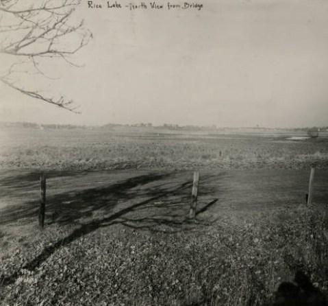
Lake Hiawatha, then Rice Lake, middle right, looking north from bridge over Minnehaha Creek in 1915. (Photo by Charles J. Hibbard from the Minneapolis Park and Recreation Board in the Minnesota Reflections Digital Library.)

Lake Hiawatha before dredging and golf course creation looking south in 1922. Lake Nokomis, with a lakeshore already defined by dredging, is on the horizon just right of center. (Hibbard, Minnesota Reflections Digital Library.)

It’s hard to tell from this 1929 photo looking east across the Lake Hiawatha and soon-to-be golf course how much water is standing. (Hibbard, Minnesota Reflections Digital Library. The same collection has many more photos of the area from different years.)
When you see the lake today, it’s hard to imagine that these photos show the same property. And it likely wouldn’t exist as a lake today if not for golf. The photos also illustrate the problems that still exist with excess water on the golf course and in the neighborhood.
Lake Hiawatha, or Rice Lake as it was called until 1925, was viewed primarily for its relationship to Minnehaha Creek for much of Minneapolis’s early history. As described in the history of Lake Hiawatha Park I wrote for the park board, the lake was viewed as a potential reservoir to maintain a constant flow of water over Minnehaha Falls. Absent that, Theodore Wirth argued that the lake would be more attractive as a meadow than a swamp and recommended draining it by diverting Minnehaha Creek through Lake Nokomis.
What changed thinking about the lake was golf. The Lake Hiawatha wetland was viewed as the only undeveloped plot of land in south Minneapolis large enough to hold a golf course. (In the late 1910s, 150 acres was considered sufficient for a golf course.) Minneapolis’s first two golf courses were at Wirth Park (then Glenwood) and Columbia Park in north Minneapolis. Gross (then Armour) and Meadowbrook golf courses, were added in the mid-1920s, both outside city limits and neither in south Minneapolis.
The other reason for maintaining Lake Hiawatha as a lake and dredging it much deeper is obvious when you look at the panoramic view above: the property was dead flat. Now I’m not a golfer, but I understand from those who are that dead flat does not make the most interesting golf courses (unless you’re being caressed by ocean breezes). To create a course that was more “sporty” in Theodore Wirth’s words, some variances in terrain would have to be created. For a park board that had little extra dirt—fill was always in demand because most neighborhood parks had been created on low lying land that was of little use, thus cheap, and needed filling—the best place to get fill was from a lake bottom. Wirth had already followed that formula at Lake of the Isles, Lake Calhoun, Cedar Lake and Lake Nokomis. He had used dredged material to reshape lakefront and create firmer shorelines. Why not dredge Lake Hiawatha, making it a “real” lake, and use the dredge “spoils” to create a golf course with (small) hills? One stone. Two birds. The results: another blue sheet of water, one less swamp (considered detrimental to health and beauy at that time), and another golf course, which proved in its early days to be one of the most profitable in the city.
Those who love the lake but hate the golf course might want to keep in mind that they may have one because of the other.
But that’s only part of the story that I’m still investigating. The other part of the story is what Theodore Wirth and park commissioners assumed about natural water levels in the Minnehaha Creek watershed. In the first few decades of the park board’s existence, water levels in the city’s lakes and creeks may have been higher than normal, although Minnehaha Creek was still dry at times. By the 1920s, however, water levels appear to have dropped and they remained low for the next few decades at least. That was when Lake Hiawatha and the Hiawatha Golf Course were created. In many years mid-century, there was no water in Minnehaha Creek except early spring and late fall. In the late 1950s water levels in the Chain of Lakes were sometimes seven feet below where they had been fifty years earlier.
The assumptions made about water levels, which affected depths of dredging and heights of filling, continue to impact how water flows or doesn’t in and around Lake Hiawatha and the golf course today when water levels are near all-time highs.
I mention this history today to remind people that a park system built around water—from the acquisition of Loring Pond and Lake Harriet in the 1880s; to renovation plans for Lake Hiawatha, Minnehaha Parkway and the Lake Calhoun boathouse site; to the development of new waterfront properties along the Mississippi River downtown and in North and Northeast—require special planning, precautions and contingencies especially in a time of climate change. Water levels will fluctuate. Know the depth before you dive.
As a postscript I’m told that some seats remain on the bus tour I’m leading of the city’s lakes, streams, ponds and river on August 17. The tour is organized by Preserve Minneapolis. Reserve your seat on the bus for the two-hour tour here.
David Carpentier Smith
The Last of the Deluge: Minnehaha Creek Floods Meadowbrook Golf Course
Filed under: Minneapolis Golf Courses, Minneapolis parks, Minnehaha Creek | Tags: Hiawatha Golf Course, Meadowbrook Golf Course, Minnehaha Creek, Theodore Wirth Golf Course
Leave a comment Ok, enough about flood waters—but I had to post a couple more shots of water winning. These were taken at Meadowbrook Golf Course, the Minneapolis park course located in St. Louis Park and Hopkins on Excelsior Boulevard. (Click here to learn why the Minneapolis Park Board owns a golf course outside city limits. In fact, it owns four courses outside of Minneapolis: Theodore Wirth, Francis A. Gross, Fort Snelling and Meadowbrook.)

Meadowbrook Lake! Meadowbrook Golf Course — seen here from Excelsior Boulevard in St Louis Park — usually doesn’t have a lake in the middle of it. A pond on Minnehaha Creek on the eastern edge of the course — several hundred yards from this scene — was created in the late 1920s shortly after the course opened, because high water in the creek flooded part of the course. The pond was dredged to hold potential flood water and the earth dredged for the pond was used to raise the level of the course around it. That has worked pretty well through the history of the course — but not when Minnehaha Creek rises this much. This photo was taken more than a week after the heavy rains of June 19. (David C. Smith)
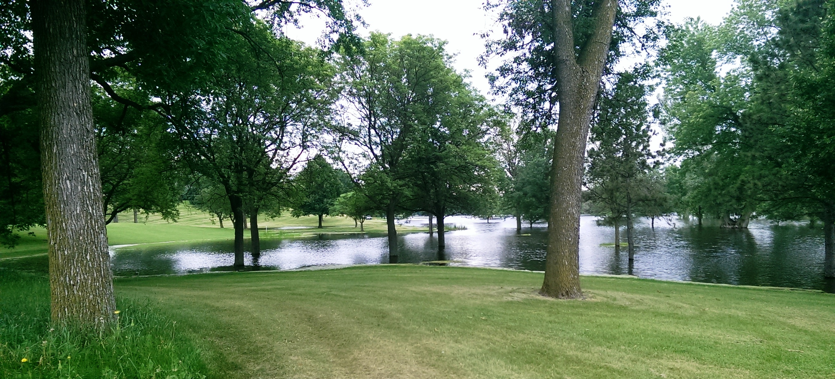
Another shot of the new lake in Meadowbrook Golf Course taken from near Excelsior Boulevard. (David C. Smith)

A different “lake” view, this looking east from Meadowbrook Road through the heart of the golf course. The 14 water hazards the course normally features appear to have merged into one. (David C. Smith)
As of this afternoon, the only Minneapolis public courses that remain closed due to flooding are Meadowbrook and Hiawatha. Only this afternoon, Theodore Wirth began allowing the use of carts again. There is no target date for when the two closed courses will reopen, but it’s likely to be awhile—especially with another 2-4 inches of rain forecast for this weekend.
Not only will cleanup and repair of these courses be expensive, but the revenue they typically generate will be lost to the Park Board for much of the summer.
David C. Smith
© 2014 David C. Smith
Minnehaha Falls and Creek: Flood Stage
Filed under: Minneapolis Lakes, Minneapolis parks, Minnehaha Creek, Minnehaha Falls | Tags: Hiawatha Golf Course, Minnehaha Creek, Minnehaha Falls, Minnehaha Parkway
Comments (10) As we await another early evening thunderstorm, I will post a few historic photos of Minnehaha Creek and Minnehaha Falls taken earlier this afternoon. I call them historic because I’ve never seen the creek this high. One man I encountered on my explorations claimed it was a record water level for the creek. I’ll have to look that up.
The entire length of the creek was flooded, of course, even a few hours after the rain had stopped, but these three photos establish landmarks.

The bridge to nowhere. The creek normally flows under the bridge near the top of the photo. Minnehaha Parkway at Humboldt Avenue South, south of the Lynnhurst Recreation Center. (David C. Smith)
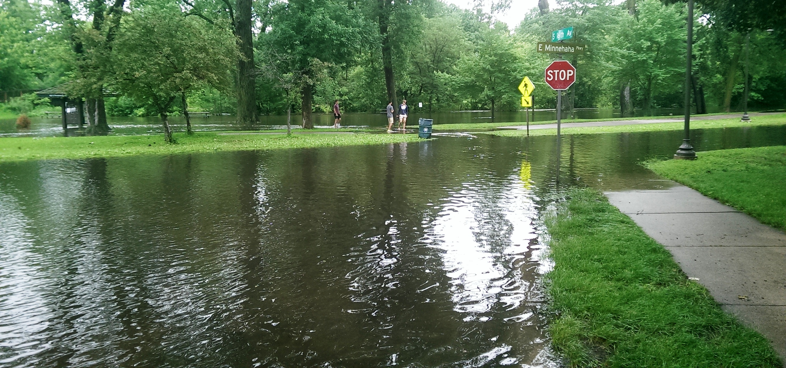
Minnehaha Parkway at 16th Avenue South. (David C. Smith)

Looking west on Minnehaha Parkway at Cedar Avenue South. (David C. Smith)
A man I met near Cedar Avenue claimed that the water reached a similar level after a 1988 thunderstorm, but the water subsided very quickly. Today it didn’t. Minnehaha Parkway was barricaded at many points east of Lake Harriet.

More than a water hazard. Hiawatha Golf Course looking south from E. 43rd Street near Standish. That is not Lake Hiawatha in the foreground. (David C. Smith)

A romantic interlude at the famous rapids of Minnehaha Creek! This is only a few yards upstream from the Hiawatha statue. (David C. Smith)
Some early descriptions of the Falls mentioned the heavy mist generated by the falls. That was true today. There was no rain falling while I was taking the pictures below, but I could feel the water in the air. Not quite as dramatic as Victoria Falls, where the cloud of mist over the falls is visible for miles — it’s called Mosi-o-Tunya, the Smoke that Thunders — but still impressive for this normally modest stream in mid-summer.
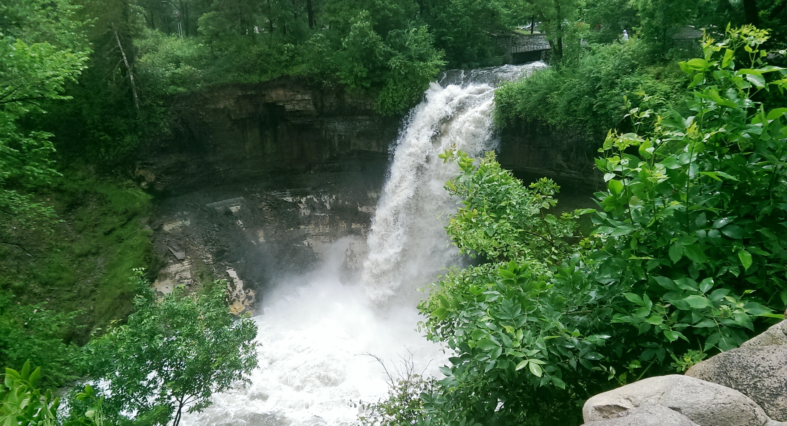
The falls made famous by Henry Wadsworth Longfellow. I recently discovered startling early plans for the park at the falls that I am waiting for permission to reveal. Stay tuned. (David C. Smith)
Unfortunately such high water levels, like the strong winds of recent years, require expensive cleanup efforts from the park board, stretching already tight park maintenance budgets. Kudos and thanks to the park board crews that will put our water-logged parks in beautiful condition yet again.
David C. Smith
© David C. Smith
Does anyone have any pictures to post of Bassett’s Creek in Theodore Wirth Park or downstream to Bryn Mawr before it dives underground? Is Shingle Creek any better?
Bombers Over Lake Nokomis
Filed under: Minneapolis Golf Courses, Minneapolis Lakes, Minneapolis parks | Tags: Hiawatha Golf Course, Lake Hiawatha, Lake Nokomis, Wold Chamberlain Field
Comments (2) My favorite photo of Lake Nokomis was taken in 1932. The true subject of the photo was a squadron of Martin bombers visiting Wold-Chamberlain Field from Langley Field, Virginia, but beneath them is a fascinating scene of park developments.

The Martin Bomber was the first American airplane built specifically to carry bombs. First built during WWI, the biplane version of the bomber was replaced by a monoplane version designed in 1932. (Minnesota Historical Society)
The photographer isn’t listed in the Minnesota Historical Society’s database, but it may have been taken by J. E. Quigley Aerial Photography. Quigley produced most of the other aerial photos of Minneapolis from that era.
The bare ground at the left wingtip of the middle plane is the Hiawatha Golf Course under construction. The course didn’t open until 1934. Dredging in Lake Hiawatha had just been completed in 1931.
It doesn’t show up well at this size, but the Nokomis Beach is packed (beneath the front airplane). You can see the diving towers in the lake.
Also note how barren the Nokomis lakeshore is. It had been created from lake dredgings only 15 years earlier.
Four years after dredging was completed at Lake Nokomis and the dredge fill had settled, the park board cleared and graded the land. (Minneapolis Park and Recreation Board)
The dredge fill settled for four years before it was cleared of brush and willows that had grown up in the intervening years and the land was graded for athletic fields. The huge piles of brush in the background were burned. Of course the land was graded by horse teams. Even with that much time for the dredge fill to settle before it was graded, the playing fields continued to settle and were re-graded in the 1930s as a WPA project.
Even after ten years of tree growth, the lake shore doesn’t look very shaded in the 1932 photo.
The Cedar Avenue Bridge at the bottom of the aerial photo was the subject of great debate at the park board, Minneapolis City Council, the Hennepin County Board and Village Council of Richfield in the 1910s. Park superintendent Theodore Wirth’s plan for the improvement of Lake Nokomis in the 1912 annual report included rerouting Cedar Avenue around the southwest corner of the lake to eliminate a “very unsightly” wooden bridge over the edge of lake at the time. Even though the park board owned all the shores of the lake and the lake bed, the south end of the lake was then in Richfield, which is why the county and Richfield were involved in decisions on the bridge. Despite the park board position that building a bridge would be more expensive and less attractive, it was built—and paid for with Minneapolis bond funds—partly due to opposition by Richfield landowners to plans to reroute Cedar. By 1926 that line of opposition would have been partially removed when Minneapolis annexed about a mile-wide strip of Richfield that placed all of Lake Nokomis inside Minneapolis city limits.
David C. Smith
Minneapolis Park Memory: Treasure
Filed under: Minneapolis Golf Courses, Minneapolis Park Memory, Minneapolis Parks: General | Tags: Hiawatha Golf Course, Lake Harriet, Minnehaha Park, Powderhorn Park
Comments (1) How I have enjoyed the Minneapolis parks: watching fireworks at Powderhorn Park; concerts at Lake Harriet, with picnics on the hill; swimming and canoeing at Calhoun; walking in Minnehaha Park and eating crab cakes at Sea Salt; walking and biking at Nokomis; watching my children play hockey at various parks, and baseball at McRae and Diamond Lake; teaching the children to skate at Diamond Lake; my sons in their early teens taking the bus from our home at 48th and Clinton all the way to Theodore Wirth Park to play golf; my boys golfing at Hiawatha and telling us that they played with two really nice “old guys.” (These “old guys” happened to be friends of ours from church and were our age, in their 40s.)
My son Glen would leave the house in the summer early in the morning, bike to Lake Harriet with his fishing equipment, climb on a tree branch overhanging the lake and stay until suppertime. He enjoyed being outdoors even if he didn’t catch fish.
But here is my most treasured memory: In 1945, my future husband took me canoeing at Calhoun and then into Lake of the Isles, and gave me my engagement ring.
Alice Streed

The Romantic Route (from City of Parks, Minneapolis Park and Recreation Board)

