Archive for the ‘Stone Arch Bridge’ Tag
Rails, Trails, and Sorrow
Filed under: Minneapolis parks | Tags: Cedar Lake Trail, Harry Perry Robinson, John Helland, Joseph McAleer, Peter Harnik, Stone Arch Bridge
 Comments (5)
 My park-related reading and the death of an important Minnesotan converged last week.
I was reading Peter Harnik’s From Rails to Trails: The Making of America’s Active Transportation Network due to my interest in the movement that led to the creation of the Cedar Lake Trail and the conversion of the Stone Arch Bridge into a pedestrian and bicycle trail. Reading about converting railroad tracks to trails took me back to one of my favorite books this year, Escape Artist: The Nine Lives of Harry Perry Robinson by Joseph McAleer. Harry Robinson, among several lifetimes (nine!) worth of accomplishments, was an advocate for creating all those railroads in the late 1800s.

As I was contemplating the efforts to create, then repurpose railroads, I saw the obituary for John Helland and an accompanying tribute to him by Dennis Anderson in the StarTribune . Helland was a retired research and policy analyst for the Minnesota Legislature. What McAleer, Harnik and Helland have in common — superficially, at least — is that I met them through these pages. Rich compensation for work that is otherwise not remunerated. They all wrote to me with questions or comments on my posts here, some of which were public and attributed, others exchanged privately in-person or by email.
I wrote a few months ago that I looked forward to reading McAleer’s biography of Harry Robinson, an Englishman who put his stamp on Minneapolis in the 1880s as a journalist, friend to the powerful, and son-in-law of one of Minneapolis’s most influential men, Thomas Lowry. The book lived up to my expectations as it unfolded the story of Robinson’s journey from itinerant Oxford grad to gold prospector to journalist who was knighted for reporting from the trenches of World War I to spokesman for the expedition that discovered and opened King Tut’s tomb. Robinson had more adventures than you or I and he also wrote brilliantly about those adventures, other pressing issues, and the sometimes unsettling prejudices of his time. McAleer chose wisely in sharing freely with his readers the power and wit of Robinson’s own writing through frequent quotations and excerpts from Robinson’s journalism, correspondence, and fiction. Robinson’s considerable influence was due to his writing skill and it is appropriate that his biographer gives us the flavor of that writing.
It was Robinson’s role of railroad advocate — he founded The Northwestern Railroader, a Minneapolis-based magazine in the 1880s and was later the editor of the Chicago-based Railway Age — that resonated as I read Harnik’s book. Harnik was the cofounder of Rails-to-Trails Conservancy, which advocates converting abandoned railroads to recreation trails. He tells the story of the movement to repurpose an asset at one stage of our history into a quite different asset in a quite different time. Among the projects he mentions are not only the Stone Arch Bridge and Cedar Lake Trail in Minneapolis but also the Cannon Valley Trail in southeastern Minnesota. Harry Robinson was a champion of clearing the land and laying the track, Harnik was a champion of acquiring those same ribbons of land when they no longer carried trains and resurfacing them for recreational use. Both saw value in those strips of land that crisscrossed nearly every county in the country.
Of particular note was that Robinson and Harnik both recognized the necessity of grass roots activism to achieve their objectives. Robinson helped organize “railroad men” into local clubs that largely supported railroad management and their preferred political candidates. Robinson claimed the clubs he helped organize were non-partisan but they generally served Republican interests. After McKinley defeated Bryant in the 1896 presidential election, the new President personally thanked Robinson for his support and organizing efforts on his behalf.
Harnik’s conservancy also recognized the necessity of local champions of rail trails and also asserted its non-partisan nature — more accurately so than Robinson. He cites many examples of cooperation from both sides of the political fence. As different as their objectives appear to have been, I think its fair to say that Robinson and Harnik believed they worked for a common good and both sought allies on carefully targeted issues rather than broader ideological causes.
I was also struck by Robinson’s observations of Americans from his privileged position in English society. McAleer writes, “The American character and can-do spirit had impressed him [Harry] deeply. Twenty years later, Harry reflected on ‘the notion that every American is, without any special training, by mere gift of birthright, competent to any task that may be set him.'”
While our history carries ample warnings of the dangers of an over-zealous belief in American exceptionalism, Harry Robinson’s observations seem corroborated by Peter Harnik’s accounts. He cites many examples of people without prior qualifications taking it upon themselves to organize, plan and execute efforts to secure old railroad beds, tunnels and bridges for public use. In many cases they stood against the formidable might of railroad corporations and at times intransigent public and private bureaucracies. Harnik’s heroes come from all corners of private and public life, from those who had profit and non-profit motives as well as those who really didn’t care much about motives but saw something they thought needed doing and, as Harry Robinson would have appreciated, thought they could do.
As I consumed this stew of railroads and trails, non-partisan commitment to service, and the constantly evolving notion of the public good — against a backdrop of great adventures — came the news that John Helland had died. Dennis Anderson laid out the details of Helland’s service to Minnesota as the legislative staff person responsible for writing many of the state’s environmental and conservation laws. Anderson noted that Helland “and others like him in government, are the dutiful — and smart — ones who write the laws and policies that legislators oftentimes can only imagine.” Anderson also applauded Helland’s professional non-partisanship.
I was especially pleased that Anderson included “smart” in his description of Helland and others like him in government. From my own service in the federal government and from working closely with people in local government service, from municipal to park to library employees, I have enormous respect for employees in the public sector. Their work is in many respects more difficult than work in the private sector because they work for so many bosses and must serve, or at least consider, so many competing agendas. Yet they accomplish so much with intelligence and grace. As did John Helland.
Sir Harry Perry Robinson’s life, apart from adventure and glamor, is at its core a worthwhile jumping off point for consideration of so many pertinent contemporary issues: economics, politics and government, heritage, journalism, relations among nations, and more. Whether we agree or not with his views today, they are threads in the tapestry we have become. McAleer’s book about a man and Harnik’s book about a movement compel us to think about how we define and balance private gain and public good. Helland’s legacy, perhaps even more than the natural resources he helped conserve, is his example of how to pursue that balance.
Lost Minneapolis Parks: Highland Oval
Filed under: Lost Minneapolis Parks, Minneapolis parks | Tags: Charles A. Tenney, H.W.S. Cleveland, Highland Oval, Horace Cleveland, Oak Lake, Samuel Gale, Stone Arch Bridge
Comments (1) The elegant neighborhood on the hills surrounding Oak Lake—now the site of the Farmer’s Market off Lyndale Avenue—has been gone for decades. Oak Lake itself was filled in 100 years ago. You can read the whole story here. The latest news: I finally found a picture of one of the five small parks in the Oak Lake Addition. I give you Highland Oval.

The title on the photo is “Highland Avenue, Oak Lake Division”, but the open space in the middle of the photo can only be Highland Oval. The view is looking northwest. Tiny, isn’t it? But the effort to preserve any open green space in rapidly expanding cities was a novel concept. (Photo by Charles A. Tenney)
The photo was probably taken in the mid-1880s, before the park board assumed responsibility for the land as a park. The land was designated as park in the 1873 plat of the addition by brothers Samuel and Harlow Gale. Although I have no proof, I believe it likely that H.W.S. Cleveland laid out the Oak Lake Addition, owing largely to the known relationship between Cleveland and Samuel Gale. The curving streets that followed topography and the triangles and ovals at street intersections were hallmarks of Cleveland’s unique work about that same time for William Marshall’s St. Anthony Park in St. Paul and later for William Washburn’s Tangletown section of Minneapolis near Minnehaha Creek. It was also characteristic of Cleveland’s work in other cities.
Photographer Charles A. Tenney published a few series of stereoviews of St. Paul and Minneapolis 1883-1885. He was based in Winona and most of his photos are of the area around that city and across southern Minnesota.
Highland Oval was located in what is now the northeastern corner of the market.
As happy as I was to find the Highland Oval photo, my favorite photo by Tenney tells a different story.

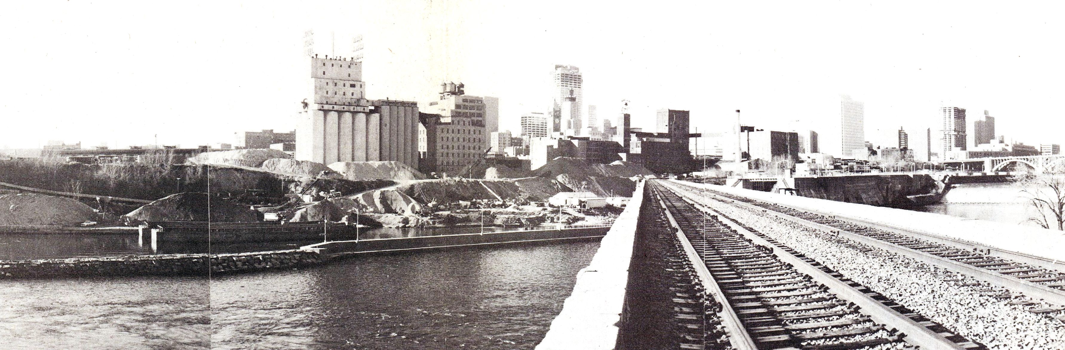
10th Avenue Bridge. (Photo by Charles A. Tenney)
At first glance, this image from Tenney’s Minneapolis Series 1883 was simply the 10th Avenue Bridge below St. Anthony Falls, looking east. The bridge no longer exists, although a pier is still visible in the river. What makes the photo remarkable for me are the forms in the upper left background being built for the construction of the Stone Arch Bridge. (See a closeup of the construction method here.) The Stone Arch Bridge was completed in 1883 — the same year the Minneapolis Board of Park Commissioners was created.
Nearly 100 years after the bridge was built, trains quit using it and several years later the park board, Hennepin County and Minnesota reached an agreement for the park board to maintain the bridge deck for pedestrians and bicyclists, thus helping to transform Minneapolis’s riverfront—a process that continues today.
Note also the low level of the river around the bridge piers. This was long before dams were built to raise the river level to make it navigable.
David C. Smith
© 2015 David C. Smith
Friday Photo: Before the Mills Were Ruins
Filed under: Mill Ruins Park, Minneapolis Parks: General, Mississippi River | Tags: Mill Ruins Park, Mississippi River, Stone Arch Bridge
Comments (8) Let’s go down to the river one more time. I have many favorite pictures of the riverfront when it was the economic engine of Minneapolis, but this is probably at the top of my list.

The west bank of the Mississippi River in downtown Minneapolis, just below St. Anthony Falls, in 1885. (Minnesota Historical Society)
You can see just a dash of the still-new Stone Arch Bridge on the right margin of the photo. The channel here is all tail race — the water that ran out of the mills after generating power.
My favorite part of this photo though is the trestle and railroad tracks that ran between the mills and the river at essentially the level of city streets. Those tail races coming out of the mills are now a part of Mill Ruins Park. The trestle and tracks are gone, but I don’t know when they were torn down. Anybody?
Below are two shots (a 3-for-1 Friday Photo!, the biggest Friday Photo discount ever) of the tail races as they appeared probably in the 1950s.

Tail races, some of which are now visible in Mill Ruins Park. (MPRB)

A closer look at the trail races and water returning to the river after its work was done. (MPRB)
Both photos are undated. They show the water coming out of the tail races. They give a much better sense of the management of water power. I’m not sure of the functions of structures and workers at this point in the water power process.
These structures were razed and covered when the Upper St. Anthony Falls Lock and Dam was built in the 1960s.
For a marvelous 360-degree panorama of Mill Ruins Park and the adjacent lock and dam go here, courtesy of the National Park Service. Learn much more about the lock and dam — one of the biggest mistakes Minneapolis and the U. S. Army Corps of Engineers ever made — at the pages of the Mississippi National River and Recreation Area.
Have a look around the park — if spring ever comes. The transformation is amazing — and thought-provoking.
David C. Smith
© Copyright 2013
Friday Photo: West Riverbank from the Stone Arch Bridge
Filed under: Mill Ruins Park, Minneapolis Parks: General | Tags: Mill Ruins Park, Stone Arch Bridge
Leave a comment I don’t want to overdo the Stone Arch Bridge, but will run that risk with this photo found by Andrew Caddock at the park board. I showed the picture recently to a group of local history buffs and asked for guesses on when it was taken. Guesses ranged mostly from 1930-1960s. The real answer is ….
View from the Stone Arch Bridge. Click for larger image. (Jim Keane, Riverfront News)
…1980. Not that long ago.
The piles of sand and aggregate in front of the old mills were used to make concrete and were owned by Shiely Co. The materials were mixed on site and used in downtown construction projects; the sand and gravel could be transported at much lower cost by barge than by truck. The company first used the area for aggregate storage when it was making the concrete to build the upper lock and dam — on the right of the bridge — which was completed in 1965. Train traffic on the Stone Arch Bridge had stopped a couple of years before this photo was taken.
The photo appeared in the December 1980 issue of Riverfront News, a publication of the Minneapolis Riverfront Coordination Board, which included representatives of the major agencies of Minneapolis government.
The land under the sand piles is now Mill Ruins Park. The Guthrie Theater would be near the left edge of the photo
David C. Smith
Friday Photo: How A Stone Arch Was Made
Filed under: Minneapolis parks, Mississippi River | Tags: Father Hennepin Bluffs, Mill Ruins Park, Stone Arch Bridge
Comments (5) The Stone Arch Bridge over the Mississippi River in downtown Minneapolis is becoming one of the iconic images of the city. Have you ever wondered how those arches were made? I have. So I found this photo of the bridge under construction. The deck of the bridge is maintained by the Minneapolis Park and Recreation Board, so let’s call it a park. Day and night the bridge provides the best views of the city. A hike over the bridge between Mill Ruins and Father Hennepin Bluffs, in either direction, is a must for visitors and residents.
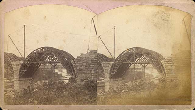
This stereoscope image shows the stone arches being built over forms in 1883. (Henry Farr, Minnesota Historical Society)
The two-track railroad bridge was being built at the time the park board was created in 1883.

The Stone Arch Bridge being completed in 1883. (Burlington Northern, Minnesota Historical Society)
This is another favorite shot of the bridge as it neared completion
David C. Smith
A Railroad Town
Filed under: Minneapolis parks, Mississippi River | Tags: Above The Falls, Mississippi River, Stone Arch Bridge
Comments (1) To reinforce recent articles that addressed the dominance of railroads and mills along the Minneapolis riverfront, I found these photos from about 1920 to be fascinating. Both are from the photo collection of the Minnesota Historical Society, a fabulous resource for understanding how our city and state came to be. The collection includes other aerial photos by Paul W. Hamilton of Minneapolis and St. Paul from the same time. They’re worth a look.

The west bank of the Mississippi River in Minneapolis looking downriver from above St. Anthony Falls. Nicollet Island is far left, the Stone Arch Bridge upper left in about 1921 (Paul W. Hamilton, Minnesota Historical Society)

North Minneapolis at Plymouth and Washington looking east toward the Mississippi River and Plymouth Bridge in background. Railroads consumed a lot of land in about 1920 on the west bank. (Paul W. Hamilton, Minnesota Historical Society)
When you look at these pictures it’s obvious why the Civic Commission and the park board were interested in reclaiming the riverfront 100 years ago.
David C. Smith
Low River Redux
Filed under: Minneapolis parks, Mississippi River | Tags: Ford Dam, Mississippi River, St.Anthony Falls, Stone Arch Bridge
Comments (2) The dry weather this year is evident on the Mississippi River at St. Anthony Falls. A couple weeks ago I posted an aerial photo of St. Anthony Falls when it was very dry in 1955. The water levels on the river appear to be similar now. Larry Dillehay sent this photo taken on the afternoon of October 2. The concrete apron at the Falls isn’t quite dry, but there’s not enough water flowing to make a ripple at the bottom. The horseshoe dam above the falls is now completely out of the water. What a gorgeous day—again.

St. Anthony Falls in a very dry year, as seen from the Stone Arch Bridge, October 2, 2012. (Photo: Larry Dillehay)

Horseshoe dam exposed, with Nicollet Island in background. From 3rd Avenue Bridge just upriver from St. Anthony Falls, October 2, 2012 (Photo: Larry Dillehay)
David C. Smith
Postscript: Both the horseshoe dam and Lock and Dam #1, or Ford Dam, were repaired while the water was at this level, suggesting that while the summer had been very dry, the water levels had been lowered intentionally by the U.S. Army Corps of Engineers to facilitate mainteneance.
Where is De Soto Harbor?
Filed under: Minneapolis parks, Mississippi River | Tags: De Soto Harbor, Ford Dam, Mississippi River, Stone Arch Bridge
Comments (5) With the completion of the High Dam, now the Ford Dam, on the Mississippi River just upstream from Minnehaha Creek in 1917, the Minneapolis park board was pressed to name the new reservoir that formed behind the dam. Without explanation, it settled on the odd name of “De Soto Harbor” on July 3, 1918. I have found no evidence that the name was ever changed, rescinded — or used.

The “High Dam” nearing completion in 1917. It became known as the Ford Dam in 1923. This was before the Ford Bridge was built later in the 1920s. (from City of Parks, Minnesota Historical Society)
The harbor was named for Hernando de Soto, the Spanish explorer who was believed then to have been the first European to see the Mississippi River about 1540. De Soto’s expedition never got anywhere near Minnesota, however, crossing the Mississippi near Memphis, Tennessee. De Soto’s story is one of some “firsts” in European exploration of North America, but also considerable brutality toward native people.
Other names the park board considered for the reservoir were Lafayette Lake, Liberty Lake, Lake Minneapolis and St. Anthony Harbor. (Minneapolis Tribune, June 27, 1918.)
The name chosen was unusual because the park board had not, for the most part, named park properties for people not connected with the history of the city or state. (Logan Park was a notable exception.) The decision to name parks only for people of local historical significance was adopted as an official policy of the park board in 1932. The policy was revised in 1968 to enable Nicollet Park to be renamed Dr. Martin Luther King Park.
Of course, some park features on the Minneapolis map—such as St. Anthony Falls, Lake Harriet, Lake Calhoun, Minnehaha Creek—predate by decades the creation of the park board in 1883.
The park board had been involved in issues surrounding dam construction for years by the time it named the reservoir, first with the Meeker Island Dam and later the “High Dam.” From as early as 1909 the park board had sent representatitives to meetings on high dam construction held by the US Army Corps of Engineers and in 1910 had requested that the park board receive half the electricity generated by the dam in exchange for “flowage rights” over land the park board owned. The government did not agree, even though the park board lost 27 acres of land for the reservoir in 1916. Included in that acreage were several islands in the river. The park board granted rights to cut down timber on one island in the river to a local charity before the trees were submerged. The board noted that neither the park board nor the Corps of Engineers wanted a stand of dead timber in the middle of the new reservoir.
Few photos I have seen give a good picture of water levels in the Mississippi before the dams were built. One of the most dramatic is this one of the Stone Arch Bridge in 1890.

Stone Arch Bridge 1890, before any dams downstream created reservoirs. (Minnesota Historical Society)
I don’t know what month the photo was taken, although foliage says summer. Perhaps the river was unusually low in late summer, but to see the Stone Arch Bridge nearly completely out of the water is unusual.
David C. Smith

