Archive for the ‘Mill Ruins Park’ Category
The Printing Plant and The Parks
Filed under: Grand Rounds, Mill Ruins Park, Minneapolis parks | Tags: James Rice Parkway, Minneapolis Central Riverfront, Stone Arch Bridge, West River Parkway
 Leave a comment
 Amid the debate about what should be done with the Minnesota StarTribune’s former printing plant in the North Loop and complaints about the tardiness of printed newspapers that now arrive in trucks from Des Moines, we’ve lost sight of the transformative effect of that printing plant on the city. When that plant was built forty years ago there was scarcely a North Loop and the Mississippi River was closed to downtown. The deal that was made to build the printing plant changed Minneapolis. For the better.
Since the mid-1970s the city, the park board and the housing authority had been working together through the Riverfront Development Coordinating Board (RDCB) to create a plan to make the central riverfront an asset to the city. Below St. Anthony Falls, both St. Paul and Minneapolis had done a laudable job of protecting the riverbanks through the unique gorge and preserving them in their natural state for posterity — except for the river becoming a reservoir behind the Ford Dam, but that’s another story. But ever since the creation of Minneapolis more than a century earlier, the downtown or central riverfront above the falls was dominated by mills — lumber, then flour — and the railroads that serviced them. The city owed its existence to the river and its waterfall.
By the mid-1900s, however, that had changed. Mills no longer relied exclusively on the power of falling water, they could be built almost anywhere, and railroad travel and shipping was in transition as cars, trucks and airplanes changed the way we consumed and travelled. The two Minneapolis railroad passenger depots, the Milwaukee Road and the Great Northern, closed in 1971 and 1978 respectively. With the closure of the Great Northern Depot on Hennepin Avenue, the Stone Arch Bridge closed, too.
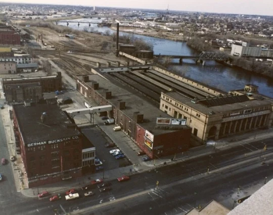
With the closure of the depot, the real estate subsidiary of the Burlington Northern Railroad wanted to develop their land from Hennepin up to the Plymouth Avenue bridge near the top of the photo. And they had a customer. The Minneapolis Star and Tribune wanted to build a new printing plant on the railroad’s land. But to do that they needed some changes in zoning from the city. To encourage that and enhance the value of remaining land for residential development the company offered to donate to the city 22 acres of riverfront. The donation valued at $11 million was accepted by the city in 1985.
One condition attached to the donation was that the park board had to build a parkway along the river — from Plymouth Avenue to Portland Avenue — in two years. So what is now James Rice Parkway was created and dedicated in the fall of 1987 as the Minnesota Twins took on the St. Louis Cardinals in the World Series. As the parkway and riverfront park were being developed, the Minneapolis Star and Tribune’s new printing plant was built, too.
The new parkway was named for James Rice, a state legislator from northeast Minneapolis who played a key role at the Minnesota legislature in securing funding for the construction of the parkway. With the new parkway from the Falls to Plymouth Avenue in place, the park board had a target and incentive to then connect Rice Parkway with West River Parkway which was accomplished with some complicated land deals in the 1990s. As various parcels were acquired for that connection the park board also developed Mill Ruins Park and First Bridge Park and converted the Stone Arch Bridge to an incredible pedestrian amenity. And it made possible a continuous park connection from North Minneapolis to Minnehaha Falls.
That connection was critical to furthering the vision of parks along the whole length of the riverfront in Minneapolis, a vision that is being realized more each year with acquisition and development of parks further and further upriver.
The deal that was made to enable construction of the newspaper printing plant was a turning point in the development of the central riverfront. It opened the riverfront to extensive residential, commercial and entertainment development on former railroad property and beyond. The opening of the river to the city would have likely happened anyway eventually, but it was certainly accelerated by the land donation for a parkway. Let’s hope that the next phase in the history of that parcel of land has as positive an effect on the city.
David Carpentier Smith
Friday Photo: Before the Mills Were Ruins
Filed under: Mill Ruins Park, Minneapolis Parks: General, Mississippi River | Tags: Mill Ruins Park, Mississippi River, Stone Arch Bridge
Comments (8) Let’s go down to the river one more time. I have many favorite pictures of the riverfront when it was the economic engine of Minneapolis, but this is probably at the top of my list.

The west bank of the Mississippi River in downtown Minneapolis, just below St. Anthony Falls, in 1885. (Minnesota Historical Society)
You can see just a dash of the still-new Stone Arch Bridge on the right margin of the photo. The channel here is all tail race — the water that ran out of the mills after generating power.
My favorite part of this photo though is the trestle and railroad tracks that ran between the mills and the river at essentially the level of city streets. Those tail races coming out of the mills are now a part of Mill Ruins Park. The trestle and tracks are gone, but I don’t know when they were torn down. Anybody?
Below are two shots (a 3-for-1 Friday Photo!, the biggest Friday Photo discount ever) of the tail races as they appeared probably in the 1950s.

Tail races, some of which are now visible in Mill Ruins Park. (MPRB)

A closer look at the trail races and water returning to the river after its work was done. (MPRB)
Both photos are undated. They show the water coming out of the tail races. They give a much better sense of the management of water power. I’m not sure of the functions of structures and workers at this point in the water power process.
These structures were razed and covered when the Upper St. Anthony Falls Lock and Dam was built in the 1960s.
For a marvelous 360-degree panorama of Mill Ruins Park and the adjacent lock and dam go here, courtesy of the National Park Service. Learn much more about the lock and dam — one of the biggest mistakes Minneapolis and the U. S. Army Corps of Engineers ever made — at the pages of the Mississippi National River and Recreation Area.
Have a look around the park — if spring ever comes. The transformation is amazing — and thought-provoking.
David C. Smith
© Copyright 2013
Friday Photo: West Riverbank from the Stone Arch Bridge
Filed under: Mill Ruins Park, Minneapolis Parks: General | Tags: Mill Ruins Park, Stone Arch Bridge
Leave a comment I don’t want to overdo the Stone Arch Bridge, but will run that risk with this photo found by Andrew Caddock at the park board. I showed the picture recently to a group of local history buffs and asked for guesses on when it was taken. Guesses ranged mostly from 1930-1960s. The real answer is ….
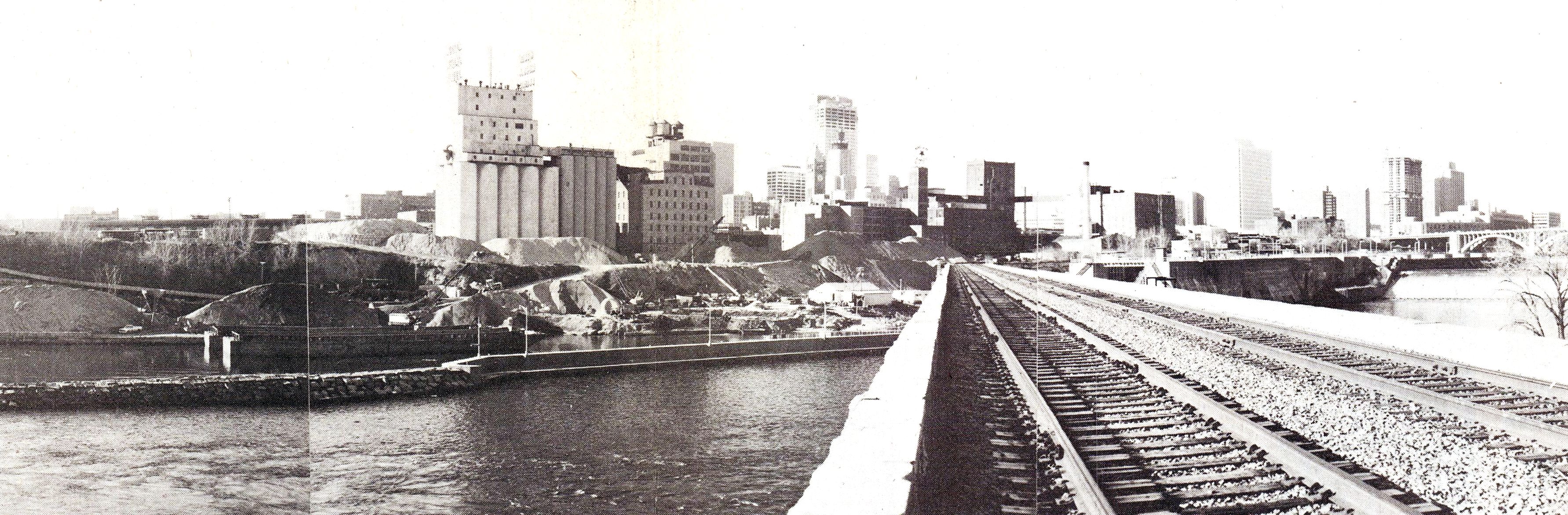
View from the Stone Arch Bridge. Click for larger image. (Jim Keane, Riverfront News)
…1980. Not that long ago.
The piles of sand and aggregate in front of the old mills were used to make concrete and were owned by Shiely Co. The materials were mixed on site and used in downtown construction projects; the sand and gravel could be transported at much lower cost by barge than by truck. The company first used the area for aggregate storage when it was making the concrete to build the upper lock and dam — on the right of the bridge — which was completed in 1965. Train traffic on the Stone Arch Bridge had stopped a couple of years before this photo was taken.
The photo appeared in the December 1980 issue of Riverfront News, a publication of the Minneapolis Riverfront Coordination Board, which included representatives of the major agencies of Minneapolis government.
The land under the sand piles is now Mill Ruins Park. The Guthrie Theater would be near the left edge of the photo
David C. Smith