Archive for the ‘Theodore Wirth Park’ Tag
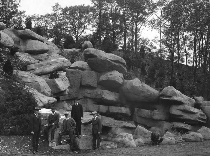
Park Puzzlers: Wirth, Gross and Minnehaha
Filed under: Minneapolis parks | Tags: Gross National Golf Course, Minnehaha Park, St. Anthony Parkway, Theodore Wirth Park
 Comments (3)
 Metal objects have been found in three places which have puzzled people. What are they? Do they serve park purposes?
Michael Fleming asked a question I can’t answer. Maybe one of you can. He sends these two pictures of metal posts in Theodore Wirth Park across Golden Valley Road from the Golden Valley Fire Station near the intersection of Bonnie Lane.


If you know what these are, leave a comment.
I also found another marker on park land similar to the one described by Craig Johnson in a post a few years ago. This marker was found along the sidewalk on the west side of Gross National Golf Course in St. Anthony, presumably on another park boundary. Gross is one of three golf courses owned and operated by the Minneapolis Park and Recreation Board (MPRB) that are wholly or partly outside of Minneapolis city limits. The others are Wirth and Meadowbrook. A fourth golf course operated by the MPRB outside of city limits is on leased land at Fort Snelling. (The park board is the only Minneapolis government entity allowed to own land outside of city limits, which is also why the park board owned and developed the Minneapolis-St. Paul International Airport from 1926 until the Metropolitan Airports Commission was created by the legislature to operate the airport in 1943.)


Finally, Rene Rosengren sent another picture of old machinery near the dog park at Minnehaha.

Based on the information Rene provided, I am quite certain that this is on former Bureau of Mines land and not part of Minnehaha Park. I think it unlikely that this was left behind by limestone quarry work in the park and was part of Bureau of Mines project.
If you have other ideas or can identify these objects, we’d like to hear from you.
David Carpentier Smith
Between Wirth Par 3 Golf Course and Twin Lake: What’s the Story?
Filed under: Wirth Park | Tags: Theodore Wirth Park, Twin Lake
Comments (8) I recently received a question from a reader that I can’t answer, so I thought maybe someone else could. I am not a golfer and I have never explored the area west of the Wirth Par Three golf course. Here’s the question:
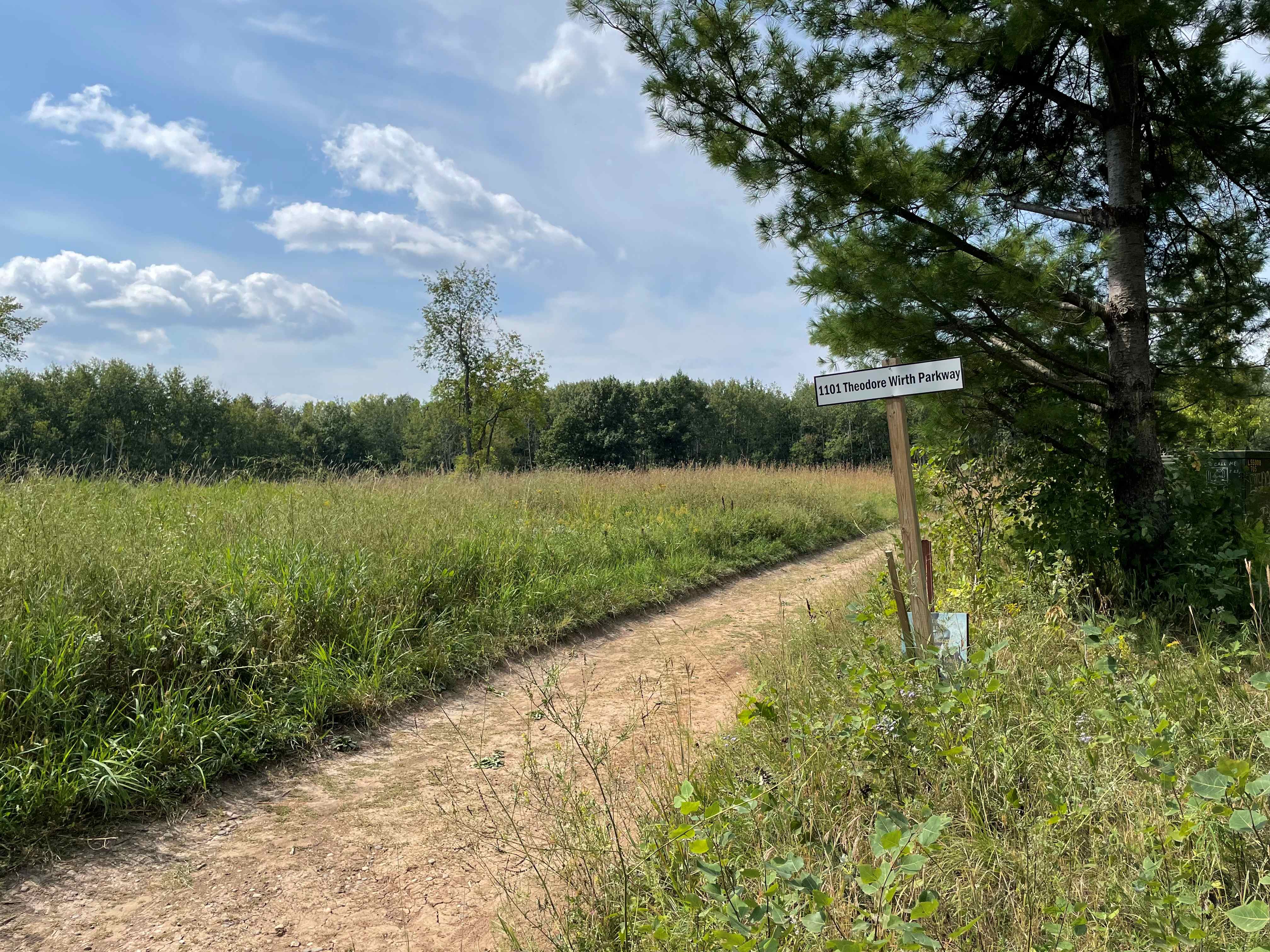
“I am wondering if you know any of the history about a seemingly out-of-place beautiful meadow/clearing just west of the 3rd hole of the Theodore Wirth Par 3 golf course. You cannot see it from the golf course but it’s easily accessible by the trails in the area.
Nestled in the meadow is a grass trail with remnants of an old asphalt trail in a tiny section, which makes me wonder if the area has an interesting “lost” history. A bit further west within those woods are remnants of an old wooden staircase built into the hillside leading down to Twin Lake. I speculate that over 50 years ago that it might have been a popular swimming area for Minneapolis residents.
Any information you may have on that meadow, as well as the history of the staircases down to the lake would be very intriguing.”
Thanks, Derek. If anyone can shed light on the landscape there and its history, please jump in. Any memories of the place?
Did you know that at it’s largest Theodore Wirth Park, previously Glenwood Park, was bigger than Central Park in New York? Park acreage was reduced when Highway 12, now I-394, cut off the southern part of the park. Part of the land south of the highway was sold to The Prudential Company for an office building in the 1950s. That was the largest ever loss of Minneapolis park land in one chunk, although the Ford Dam flooded many acres of park land along the river in the 1910s and freeway construction sliced off pieces of parkland in all parts of the city since the 1960s.
David C. Smith
Derek sent the following photos to illustrate the meadow and path. Thanks!


Charles Spears Interview: In Memoriam
Filed under: Minneapolis parks | Tags: Charles Spears, Eloise Butler Wildflower Garden, Friends of the Wild Flower Garden, The Fringed Gentian, Theodore Wirth Park
Comments (1) I received an email today with news of Charles Spears’ death. Spears was superintendent of Minneapolis parks 1978-1980. Spears spent his life in park management. In addition to his time in Minneapolis, he worked for Nashville and New Orleans city parks, as well as state parks in Kentucky and West Virginia. Although his tenure in Minneapolis was short, I found a brief interview he gave to The Fringed Gentian, the newsletter of the Friends of the Wild Flower Garden. I found it interesting to note what has changed — and what hasn’t — in the last forty-four years of park management.
The interview below is reprinted with permission from the Friends of the Wild Flower Garden. I highly recommend a visit to their website and their newsletter using the links above. Their support of the Eloise Butler Wildlfower Garden in Theodore Wirth Park has been continuous since the “Friends” were established in 1952.
A CONVERSATION WITH CHARLES SPEARS — NEW MINNEAPOLIS PARKS
SUPERINTENDENT 7/13/79
Printed in The Fringed Gentian™ Vol. 27 No.3; Vol. 27 No.4 and Vol. 28 No.1. Interview with Lynn Deweese.
What do you see as the major strengths of the Minneapolis Park System?
The major strength is the legacy that has been left us by previous park boards and superintendents in providing both open spaces and recreational facilities for now and the future. Minneapolis has done an excellent job; in fact, I think it is the finest park system in the United States -because of the lakes, parkways, bikeways, and natural areas such as the Eloise Butler Wild Flower area at Theodore Wirth Park, the Robert’s Bird Sanctuary area at Lake Harriet, and the Diamond Lake area where plans of establishing nature trails around the lake by 1981 are under way.
What do you see as the major weaknesses of the Park System?
Well, I don’t see the weaknesses as being in the System as much as I see financial problems in the future. System-wise, we have property and buildings to do many things – but programing and peoples’ needs are changing fast. But it will change even more dramatically in the next few years due to the gasoline and energy shortages. It is already happening. People will be staying home more and taking shorter trips. They will be home more weekends, seeking more family recreation, more programming, more classes. They will be here to be served more -both city and suburban people. Regional parks will be used more than the state and national parks.
What moves are now being made to cooperate with suburban and county parks?
We are in process now of having meetings with the Hennepin County Park Reserve system, and are trying to plan together so that our cross country walking and biking trails from the city will tie into county and suburban extensions. For instance, the Shingle Creek system will tie in with one that is being built by Brooklyn Center and the Hennepin County Reserve system. This linking of the city with the suburbs by bicycle paths will be increasingly important as bicycles become a more important mode of transportation for
some people in the future. But there must be proper planning and co-ordination of these trails so they do not too often dead end at city boundaries. The regional park system idea is also being studied through the Metropolitan Planning Council which includes Ramsey and other metro counties as well aa Hennepin.
Knowing the special bias of the FRIENDS, what do you see as the place of the Eloise Butler Garden in the park system?
I see it as a very important function, Where else can city youngsters who possibly cannot afford to go to other places find the native plants. I think it is important that they have a place such as your Garden, or the Diamond Lake area, or the refuge at Lake Harriet, or getting back into some other areas that are not mowed so completely. In fact, we are looking at the possibility that we may be mowing too much. Maybe there are places we should not mow to encourage more wild life, for habitat and also maybe to save some money.
Do you see some changes that would be desirable at ELOISE?
I would be open to ideas from people such as the FRIENDS, who are active in that area, and would be guided by what they feel because they have been around it for some time. I think I would like to see a somewhat more active program for the inner-city youth, with perhaps a trained person, or persons, to help with guided walks and the development of wild life appreciation. Staffing and transportation costs have perhaps held back this development. We are starting that sort of programing in the Diamond Lake area, using our own staff -our horticulturist, Mary Maguire Lerman, and our new environmentalist, Mike Ryan.
What role do you see the FRIENDS having?
I see it as one of continuing protection of the area. Without it where would the Garden’s voice come from. There have been periods when lobbying was the only thing the FRIENDS represented. That is one of their strengths. Also, I would like them to work up special projects that might take certain amounts of money not available from the Park’s budget and be active in raising the money. The Garden is a wonderful place, it makes you feel far away from the city.
What sorts of projects do you see the FRIENDS being involved in?
I would see them helping to better interpret what is there – the educational end of the Garden. So people do know what they are seeing and the worth of it. They should come away from there with a better feeling of why it is there in the first place. There are possibilities for good self-guided touring – well signed, etc. I would like to see some evening programs in the Garden. A naturalist might give a night life program one night a week during the season. In some cases that could be on a volunteer basis with members of the group doing that. They’ve got expertise – but what they need to do is share it. Wouldn’t it be nice if some of the FRIENDS could relate experiences and knowledge to youth groups, and others! For instance, this year we’ve changed our day camp program considerably. Instead of taking them out to Hennepin County Park Reserve District and putting them through the programs there – we can’t afford the busing, we can’t afford the cost – so this year we decided to do it in Minneapolis. This year we’re taking them to the Diamond Lake Area on nature hikes, taking them down the Minnehaha Creek on canoe trips. We think they need to develop an appreciation of what we have in the city. I would like to see some of our recreation center staff go through some training that would be involved in some of these things. They would go out to places like the Wild Flower Garden (I’m talking about our staff people here) and be given some background about what it is and what it does. That is the sort of leadership training we are going into. We are starting that at Diamond Lake with guided tours — this has not made use of volunteers there – rather our own staff, our horticulturist – Mary Maguire Lerman and our environmentalist – Mike Ryan. This year we acquired a new environmentalist – Mike Ryan -. He is working on several projects. His main project will be on lake pollution control and the lake level study. Now he’s doing the Diamond Lake thing because of the considerable silting caused by the interstate into that area. A number of people want us to just go in there and dredge it out. That may or may not be the answer there. It depends what sort of wild life you want there. And so the people agreed that he should have an opportunity to look at that and explain to them their alternatives before we do anything.
You may go in there and destroy more habitat by taking something out than you want to destroy. It depends what sort of habitat you want and what you want a place to do. Those are the sort of things he is going to be doing.
Speaking of new programs, how is the development of the Riverfront Plan coming?
It’s coming great. It will probably be a developed park, though there will be areas that will always be protected because they are hard to maintain. Everything from the bluff down will be undeveloped. From the bluff up, it will be more developed. There will be a great river road, bicycle paths, walking paths. These will make the area accessible to more people. I believe the river is considerably cleaner than it was ten years ago. There are plans for boat launching facilities. There will be some zoning to allow for water skiing and
other similar activities – crewing. So that people with different interests will have a place that they can do something. The river is the most exciting thing that is going to be happening around here in the next ten years.
Has there been a recent change in deciding where park plantings are to be placed?
We’ve cut back on the flowers at Lake Harriet, for instance, in order to spread it over the city a little more. We are trying to spread it around more. We feel that all sections of the city have the right to have some. In some p]aces we are putting plantings around a park identification sign in the corner of a park. And people are appreciating this. Now we are going into a program which we will call Foster a Park; wherein we will hope to get some garden clubs and some groups that will adept a certain area, especially some triangles –
we have about 40 triangles in the city that we maintain – and have these neighborhood groups accepting the responsibility for cutting the grass, plant flowers and take care of the watering. These areas could then become oasis in the city. This of course, also gives this group some additional community exposure. And of course these pleasant breaks of green are what makes this city so special.
Has the budget gone down, or is it just that the city has more needs that the same money doesn’t go as far?
Its both. Well, not really; the money itself is not going down as fast as inflation is killing it. Because of inflation our actual spendable money after operating expenses has declined and so we have had to examine our priorities and in some cases make cuts. We don’t like to cut services, but we do have to cut something. This will be a continuing problem. Probably the greatest challenge is that we are going to have more demand because of energy and less money to do it with. And I don’t know how we will make those two meet. People are going to have to take on part of the burden if they want the level of services they have been used to.
We offer our condolences to the Spears family and our appreciation for his service to parks in Minneapolis and the nation. We owe so much to the dedicated and talented park professionals and citizen volunteers who have contributed so enormously to our quality of life.
David C. Smith
Wirth Lake Mystery Structure
Filed under: Minneapolis parks | Tags: Loring Cascade, Theodore Wirth Lake, Theodore Wirth Park
Comments (2) Rod Miller asked if I knew what this was. I didn’t.
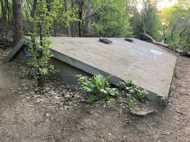
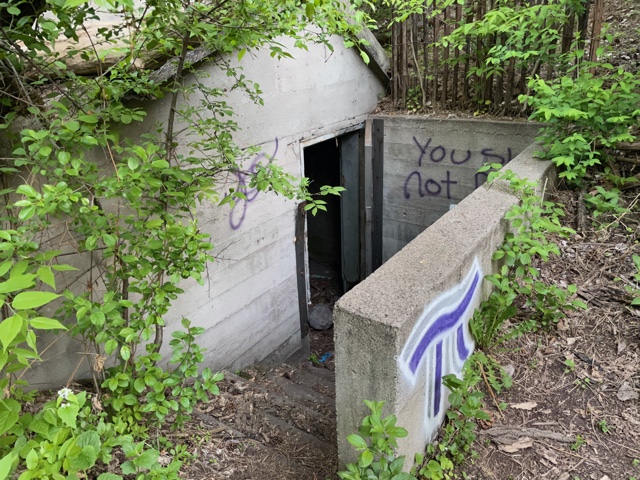
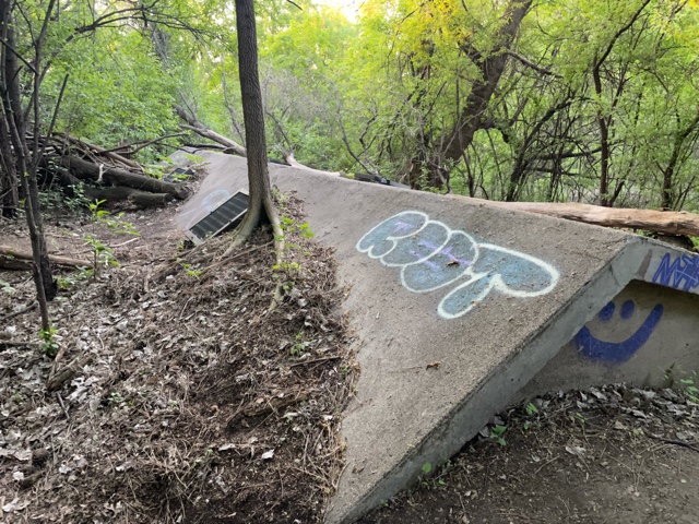
The concrete structure lies west of Wirth Lake between the lake and Theodore Wirth Parkway north of the remnants of the Loring Cascade.
Could it have been a storage facility or root cellar when the park board’s nursery was located in Wirth Park? The nursery was originally established there in the early 1900s on the suggestion of William Folwell to reduce the cost of acquiring the trees being planted throughout the city.
Or was it a structure related to the former farm on the site? The farm house served as a residence for the park board horticulturist unti the mid-1960s. Why was the structure built below grade? Do the concrete construction method or metal grates in the roof help to date the structure?
It is apparently not related to the artificial Loring Cascade which was built in the 1918 and relied on water pumped from the lake. Nor was it likely part of later efforts–beginning in the late 1950s–to pump water from Bassett’s Creek to the Chain of Lakes. There is no sign of the piping that would have been required in those efforts and the structure is probably too far north and west to have been part of those projects.
If you know what the concrete structure was used for and when it was built, please post a comment.
David Carpentier Smith
Ski Jump Update
Filed under: Minneapolis parks, Winter Sports | Tags: Minneapolis Ski Club, Ski Jumping, Skiing, Theodore Wirth Park
Comments (2) So many people have commented on my article posted nearly two years ago about the history of ski jumping in Minneapolis that I thought I should provide an update. I was prompted by an exchange of emails this week with Greg Fangel who is the owner of woodenskis.com, where he buys and sells wooden cross-country skis and provides a great deal of ski information and links to other skiing sites. I’ve edited together some of Greg’s emailed comments below, with thanks.
I’ve been an avid cross-country skier since 1974 and currently live in White Bear Lake. I’ve been researching ski history for the past 5 years or so, mostly from a Mpls/St. Paul/Minnesota point of view. In my research, ski jumping comes into play, since it’s Nordic and one of the early forms of competition. I personally know Norm Oakvik, who is mentioned in your blog. He organized many events and coached USSA teams in Minneapolis. Norm is a legend in the cross-country ski community in the Minneapolis/St. Paul area. I interviewed Norm in November of 1995 for a story in the Løype, a newsletter of the North Star Ski Touring Club.
Norm’s parents were from Norway and Norm started skiing in Minneapolis in the 1930-40s. He competed with the Minneapolis Ski Club in 1940-70s, specializing in Nordic combined in the early years. Nordic combined is ski jumping and cross-country skiing combined into one event. He was a driving force behind the National Nordic ski competition, which was held in Bloomington in 1976. Bill Koch came to ski that event.
In May of 2005 a few of the ‘movers and shakers’ in the Minneapolis ski community wanted to name a trail or system after Norm Oakvik at Theodore Wirth Park. We held a special meeting at Wirth with supporters and Norm present. Norm was so humble, that he didn’t want his name on the trails, even though he spent countless hours trail clearing, grooming, and coaching at Wirth. I don’t know how Norm is doing now, but he was recently in the hospital.
I’ve interviewed ski jumper Adrian Watt from Duluth who participated in the 1968 Winter Olympics and competed at the Glenwood jump in Minneapolis. He has some fascinating stories.
Minneapolis has a rich ski history and that should not be overlooked. We need to preserve that history for generations to come.
Greg Fangel

The ski jump at Glenwood (Wirth) Park in 1923. (Charles J. Hibbard, Minnesota Historical Society)
Greg mentioned that he’s interested in putting together an exhibit on local skiing history for a possible new project at Wirth Park.
Over the past couple years, several veterans of the Minneapolis skiing scene have commented on my original post on Minneapolis ski history. If you haven’t looked at those comments in a while, check them out. Add your own stories either here or on the original post. Thanks!
If you haven’t kept track of what’s going on with cross-country skiing in Minneapolis parks you might be surprised to find out about current trails, especially at Wirth Park. Get more skiing info at minneapolisparks.org.
David C. Smith
Brownie Lake Long Ago
Filed under: Minneapolis Lakes, Minneapolis parks | Tags: Brownie Lake, Charles J. Hibbard, Theodore Wirth Park
Comments (2) As we look forward to improvements at Brownie Lake later this year and in 2013 I find it informative to look at photos of the area long ago. Of course the construction of the Prudential Building (now housing Target offices) next to the lake in 1954 changed the lake environs considerably. (See a photo of the building under construction here.) But the lake is also hemmed in by a freeway that keeps expanding on the north and a railroad/trail corridor that keeps shrinking on the south.

An undated photo labelled “Brownie Lake with Cedar Lake in the distance.” (C. J. Hibbard & Co., MPRB)
This photo puzzles me, however. If it is Brownie Lake what is the trestle on the near side of the lake in the photo? I’ve never seen that before. Can anyone enlighten me?

Charles J. Hibbard, 1916 (Minnesota Historical Society)
The back of the photo bears the stamp of C. J. Hibbard & Co. Charles Hibbard was an active photographer in Minnesota from about 1899 until his death in 1924. Those dates establish the range of years in which the Brownie Lake picture above could have been taken.
Hibbard wasn’t directly associated with parks, although many of his photos were taken in parks, but he deserves an entry of his own here some day. Based on the photos I’ve seen he was the preeminent photographer of the city. He chronicled many places and events in Minneapolis and the state. The detail and composition of his photos are remarkable.
Both of the photos below were taken at the intersection of Theodore Wirth Parkway and Highway 12 (I-394). In the first photo, a bridge is being built to carry Wirth Parkway traffic over the new four-lane highway. This photo shows the early stages of the construction of a wider highway. Notice how narrow Highway 12 was. Trees and telephone poles hug the edge of the road.

Highway 12 and Glenwood (Wirth) Parkway, 1949 (MPRB)
The second photo, also labelled as being shot in 1949, shows the progression in road building. Today’s I-394 is, of course, much wider than the four lane highway shown here. The wetland at the north end of Brownie Lake has also been filled in.

Highway 12 expands and eats into Wirth Park, 1949 (Minneapolis Star Journal, Minnesota Historical Society)
Expansion of Highway 12 into I-394 eventually took more of the parks. On the other side of the ledger, however, the wide swath of railroads in the upper third of the photo have been converted partly into bicycle trails.
David C. Smith
Lost Minneapolis Parks: The Complete List, Part I
Filed under: Lost Minneapolis Parks, Minneapolis Parks: General | Tags: Brownie Lake, Elwell Field, The Gateway, Theodore Wirth Park
Comments (3) I’ve written about several parks in Minneapolis that are no more. Since then I’ve been asked if there is a list of those “lost” parks. The short answer is, “Not until now.” Here’s the first part of an alphabetical list I’ve compiled from park board proceedings and annual reports.
19th Avenue South and South 1st Street. 1.0 acre. The park board’s 1948 annual report noted that the site near Seven Corners had been graded and frames had been installed for swings, teeter-totters and slides for small children. The plan was to complete the playground in 1949. This parcel was leased specifically for use as a playground. I don’t know the terms of the lease, but it was still included in park inventory as leased land in the 1964 annual report. The U of M’s West Bank softball fields are now near the site. 19th Avenue South at that point is the approach to the 10th Avenue Bridge over the Mississippi River.
Bassett Triangle. 7th Avenue North and 7th Street North, 0.03 acre. Acquired from the city council December 3, 1924. Returned to the city council in 1968, after the board hired appraisers in 1967 to try to sell the property. The site is now occupied by a Wells Fargo Bank. The property was named for Joel Bean Bassett, who owned much of the land in the vicinity in the 1800s. Bassett’s Creek, underground not far away, is also named for him.
Bedford Triangle. Orlin Avenue SE and Bedford Avenue SE, 0.01 acre. This little triangle in Prospect Park was still carried on the park board’s inventory the last time I checked, but it was listed as “paved.” There is no visual evidence of the triangle. Read more about this and other triangles in the meandering streets below Tower Hill.
Brownie Lake (partial). Theodore Wirth Park west of Brownie Lake and south of Highway 12, 32 acres. The land was sold in 1952 to the Prudential Insurance Company for $200,000 and some additional land.

The southern end of Theodore Wirth Park west of Brownie Lake got a makeover when the Prudential Insurance Company purchased the land for its regional headquarters in 1952. It was the largest section of park land the Minneapolis park board has ever sold. Construction is underway in this 1954 photo. (Minneapolis Star Journal Tribune, Minnesota Historical Society)
The park board bowed to intense public pressure to sell the land beside the lake. Prudential had made it clear that the site adjacent to the lake was the only site it would consider for its offices in the city. Ultimately the park board was convinced that the benefit to the Minneapolis economy was a greater good than keeping the land as a park. The board justified its action in part by asserting that with the growth of traffic on Highway 12 (now I-394) and the widening of that road, the land west of Brownie Lake had already been isolated from the rest of Wirth Park anyway.
Cedar Avenue Triangle. Cedar Avenue and 7th Street South, 0.02 acre. The triangle was offered to the park board by Edmund Eichorn on April 15, 1891. After delaying a decision for a couple of months, the board agreed to pay Eichhorn $2,394 over ten years without interest. The triangle, adjacent to what is now the Cedar Avenue exit ramp from I-94 westbound, was sold to the state highway department in 1965 for $1,000. In April of that year the board approved a resolution to sell the property for $1,000 plus “other valuable considerations.” Later that year the board approved dropping the “other valuable considerations” clause.
Crystal Lake Triangle. West Broadway and 30th Avenue North, 0.05 acre. The triangle was supposedly purchased July 21, 1910 and sold to the state in 1962 for $2,700. It once sat at the edge of what is now the hideous intersection of Theodore Wirth Parkway, West Broadway (County Highway 81) and Lowry Avenue. Imagine if Phelps Wyman’s 1921 plan for that complex intersection had been used. What a difference it would have made in that part of Minneapolis. It would’ve been gorgeous.
Dell Place. Dell Place between Summit and Groveland avenues, 0.04 acre. Transferred from the city council April 27, 1883 when the park board was created. Citizens near the tiny lot petitioned the park board in 1907 to plant and maintain the grounds, which the park board agreed to do — if residents of the area would first pay to have the parcel curbed and filled to street grade. The street triangle was sold to the Minnesota highway department for I-94 interchanges in 1964 for $1,350. The park board had rejected the state’s first offer of $450. The park board’s appraisers valued the land at $2,250, but the park board accepted an internmediate figure instead of proceding to court with litigation.
Elwell Field I. East Hennepin and 5th Avenue SE, 3.7 acres. Purchased in 1939 from the Minneapolis Furniture Company for $5,000. Sold to Butler Manufacturing in 1952 for $55,000. The somewhat isolated field, surrounded by industrial buildings, was sold with the promise to the neighborhood to acquire another playground nearer Holmes School. Eventually the land adjacent to the school was purchased as a playground. The school on the former Holmes site, built in 1992, is now named Marcy Open School.

The first Elwell Field, 1952. Across the field is a building of the Butler Manufacturing company, which purchased the field the year the picture was taken. (Norton and Peel, Minnesota Historical Society)
Elwell Field II. 9th Avenue SE between SE 4th Street and SE 5th Street, 1 acre. The former site of Trudeau School was acquired February 4, 1953 in a trade with the school board. The park board gave up Sheridan Field next to Sheridan School at Broadway and University Avenue NE for the Trudeau property. The second Elwell Field was condemned by the state highway department for I-35W in 1962. The park board accepted a negotiated payment of $125,000 for the park in 1966.
Franklin Triangle. Franklin Terrace and 30th Avenue South, 0.05 acre. Transferred to the park board from the city council August 13, 1915 and accepted and named by the park board September 6, 1916. Taken by the state highway department for I-94 in 1962 in exchange for $1 and “other valuable considerations” again.

The beautiful cover of the park board’s 1915 annual report depicted the fountain at The Gateway. (Minneapolis Park and Recreation Board)
The Gateway. Hennepin and Nicollet avenues, 1.22 acres. There is still a Gateway park property at Hennepin and 1st Street South, but it’s not in the same location, so I consider this original Gateway a lost park. I have already provided the outline of the story for the original Gateway on the history pages of the Minneapolis Park and Recreation Board’s website at minneapolisparks.org.
Groveland Triangle. Groveland and Forest avenues, 0.21 acre. The triangle was purchased in November 1910 for $8,979. It was sold to the state highway department for the construction of I-94 in 1964 for $8,900.
That’s all for Part I of Lost Minneapolis Parks. Part II — H-R — will be out soon.
Historical profiles of all existing Minneapolis parks can be found at the website of the Minneapolis park board. Each park has its own page with a “History” tab.
If you remember anything about any of the lost parks mentioned here, please send me a note so we can preserve something of those parks — especially the property beside Brownie Lake. Any memories before Prudential moved in?
David C. Smith
© David C. Smith
Another Colorful Name Lost
Filed under: Minneapolis Park Names, Minneapolis Parks: General | Tags: Birch Pond, Glenwood Park, Theodore Wirth Park
Comments (3) The official record of the Minneapolis park board, the published “proceedings,” often don’t tell the whole story. Example: the proceedings of the park board meeting of June 6, 1910 record that the board voted that the “small lake in Glenwood Park between Western Avenue and Superior Avenue” be named “Birch Pond.” That’s been the name ever since.

What the official proceedings didn’t tell us I learned by accident while researching another issue. The June 7, 1910 Minneapolis Tribune noted the previous name of Birch Pond — the vastly more intriguing “Devil’s Glen.” I wonder how the little lake got that name. Probably a good story. But I imagine it was more offensive to some people than a lake named for John C. Calhoun.
The pond was renamed as the parkway beside it was being built by a crew of forty railroad workers imported from Hungary. The previous year, scheduled construction at North Commons and East River Parkway was postponed due to a labor shortage in Minneapolis. The park board took no chance with its new parkway through what was then Glenwood Park, now Theodore Wirth Park, and imported the workers to build it.
David C. Smith
Elusive Minneapolis Ski Jumps: Keegan’s Lake, Mount Pilgrim and Glenwood (Theodore Wirth) Park
Filed under: Minneapolis parks, Winter Sports | Tags: Bryn Mawr, Glenwood Park, Ski Jumps, Skiing, Theodore Wirth Park
Comments (35) The Norwegians of Minneapolis had greater success getting their music recognized in a Minneapolis park than they did their sport. A statue of violinist and composer Ole Bull was erected in Loring Park in 1897.

This statue of Norwegian violinist and composer Ole Bull was placed in Loring Park in 1897, shown here about 1900 (Minnesota Historical Society)
A ski jump was located in a Minneapolis park only when the park board expanded Glenwood (Theodore Wirth) Park in 1909 by buying the land on which a ski jump had already been built by a private skiing club. The photo and caption below are as they appear in the annual report of the Minneapolis Board of Park Commissioners for 1911.* While the park board included these photos in its annual report, they are a bit misleading. Park board records indicate that it didn’t really begin to support skiing in parks until 1920 — 35 years after the first ski clubs were created in the city.

Minneapolis, the American city with the largest population of Scandinavians, was not a leader in adopting or promoting the ski running and ski jumping that originated in that part of the world. Skiing had been around for millenia, but it had been transformed into sport only in the mid-1800s, around the time Minneapolis was founded. Ski competitions then included only cross-country skiing, often called ski running, and ski jumping — the Nordic combined of today’s Winter Olympics. Alpine or downhill skiing didn’t become a sport until the 1900s. Even the first Winter Olympics at Chamonix, France in 1924 included only Nordic events and — duh! — Norway won 11 of 12 gold medals.
The first mention of skiing in Minneapolis I can find is a brief article in the Minneapolis Tribune of February 4, 1886 about a Minneapolis Ski Club, which, the paper claimed, had been organized by “Christian Ilstrup two years ago.” That article said the club “is still flourishing.” Eight days later the Tribune noted that the Scandinavian Turn and Ski Club was holding its final meeting of the year. The two clubs may have been the same.
Ilstrup was one of the organizers two years later of one of the first skiing competitions recorded in Minneapolis, which was described by the Tribune, January 29, 1888, in glowing and self-congratulatory terms.
Tomorrow will witness the greatest ski contest that ever took place in this country. For several years our Norwegian cultivators of the noble ski-sport have worked assiduously to introduce their favorite sport in this country, but their efforts although crowned with success, did not experience a real boom until the Tribune interested itself in the matter and gave the boys a lift.
The Tribune mentioned the participation in the competition of the Norwegian Turn and Ski Club, “Vikings club” and “Der Norske Twin Forening.” The Tribune estimated that 3,000 spectators watched the competition held on the back of Kenwood Hill facing the St. Louis Railroad yard. Every tree had a dozen or so men and boys clinging to the branches, while others found that perches on freight cars in the rail yard provided the best vantage point.

The caption for this photo from the Minnesota Historical Society Visual Resource Database claims the photo is from the winter of 1887, but was almost certainly taken at the ski tournament held on Kenwood Hill late that winter in February, 1888.
The competition consisted of skiers taking turns speeding downhill and soaring off a jump or “bump” made of snow on the hill. Points were awarded for distance and for style points from judges.
The winners of the competition were reported as M. Himmelsvedt, St. Croix Falls, whose best jump was 72 feet, and 14-year-old crowd favorite Oscar Arntson, Red Wing, who didn’t jump nearly as far, but jumped three times without falling. Red Wing was a hot bed of ski-jumping, along with Duluth and towns on the Iron Range. (The winner was perhaps Mikkjel Hemmestveit, who along with his brother, Torger, came from Norway to manufacture skis using highly desirable U.S. hickory. The Hemmestveit brothers are usually associated with Red Wing skiing, however, not St. Croix Falls.)
A Rocky Start
Despite the enthusiasm of the Tribune and the crowds, skiing then disappeared from the pages of the Tribune until 1891, when on March 2, the paper reported on a gathering of thirty members of the Minneapolis Ski Club at Prospect (Farview) Park. “This form of amusement is as distinctively Scandinavian as lutefisk, groet, kringles and shingle bread,” the Tribune reported. “With skis on his feet a man can skim swiftly over the soft snow in level places, and when a slope is convenient the sport resembles coasting in a wildly exhilarating and exciting form,” the report continued. The article also described the practice of building snow jumps on the hill, noting that “one or two of the contestants were skilful enough to retain their equilibrium on reaching terra firma again, and slid on to the end of the course, arousing the wildest enthusiasm.”
The enthusiasm didn’t last once again. The Tribune’s next coverage of skiing appeared nearly eight years later — but it came with an explanation:
During recent winters snow has been a rather scarce article. A few flakes, now and then, have made strenuous efforts to organize a storm, but generally the effort has proven a failure. The heavy snow of yesterday was so unusual that it is hardly to be wondered at that there arose in the breasts of local descendants of the Viking race a longing for the old national pastime, skiing…The sport of skiing was fostered to a considerable extent in the Northwest, and particularly in this city, a few years ago, but the snow famine of late winters put a damper on it.
— Minneapolis Tribune, November 11, 1898
The paper further reported that the “storm of yesterday had a revivifying effect upon the number of enthusiasts” and that the persistent Christian Ilstrup of the Minneapolis Ski Club was arranging a skiing outing on the hills near the “Washburn home” (presumably the orphanage at 50th and Nicollet). The paper also reported that while promoters of the club were Norwegian-Americans, “they do not propose to be clannish in the matter.”
Within a week of that first friendly ski, Continue reading
Glenwood Toboggan Slide II: 1887
Filed under: Minneapolis Parks: General, Winter Sports | Tags: Glenwood Park, Theodore Wirth Park, toboggan slide
Comments (3) Since posting a newspaper photo of a toboggan slide on “Glenwood Hill” in 1887, I found this photo in the Minnesota Historical Society Visual Resources Database. This photo is purportedly of the same toboggan chute on the same hill in the same year, but they are obviously different places. The photo clipped from a newspaper had trees right up to the sides of the track.

The North Star toboggan chute on Glenwood Hill, 1887. (Minnesota Historical Society)
Looking up the hill instead of down, gives a completely different prespective on the possible location of the slide. I doubt that the slide in this photo is in the same location as the ski jumps that were built after the park board acquired land in the vicinity. Any guesses as to the location of this toboggan slide? Or the other one? Which one is the real “North Star” chute?
In the same wonderful photo collection, I found this picture of the St. Paul toboggan slide in front of the State Capitol, which I referred to in my earlier post.

A 1957 photo of the toboggan slide I rode as a kid, a few years later, in front of the State Capitol. (Minnesota Historical Society)
David C. Smith
Glenwood Toboggan Slide: 1887
Filed under: Minneapolis Parks: General, Winter Sports | Tags: Glenwood Park, Theodore Wirth Park, toboggan slide
Comments (4) It’s an old, wrinkled photo clipped from an unidentified newspaper, but it’s also the oldest photo I’ve seen of a toboggan slide in Minneapolis.

A privately run toboggan slide on “Glenwood” hill in 1887, years before the park board acquired land in the area.
The newspaper caption calls it the “North Star” chute and puts the date at 1887. That was two years before the first land (64 acres) was acquired for what was then Saratoga Park. The park was renamed Glenwood Park in 1890 and was renamed for Theodore Wirth in 1938. The majority of the land for the park we know today was acquired in 1909. I suspect that this hill was a part of that acquisition. Although I’m not certain, I think this slide was located near where the ski jumps were later built.
At different times the park board operated toboggan slides at Lake Harriet, Lake Calhoun, Glenwood (Wirth) Park, Columbia Park and Minnehaha Park. I don’t believe any of them were operated after the 1940s, but as always its difficult to discern from park board records when such services or programs were stopped.
The only toboggan slide I remember from growing up in the Twin Cities was the long slide erected on the approach to the State Capitol in St. Paul. I remember it being operated as a part of the St. Paul Winter Carnival. It was one of the highlights of winter life as a boy in St. Paul.
David C. Smith
Minneapolis Park Memory: A Friend of Loring Park
Filed under: Minneapolis Park Memory | Tags: Loring Park, McRae Park, Minneapolis parks, Powderhorn Park, Theodore Wirth Park
Comments (1) After arriving in Minneapolis in September 1941, the first city park I became familiar with was Loring. I had come to enter nurse’s training at Eitel Hospital, and the park was right across the street. The park provided a beautiful view from patients’ rooms. It was also an oasis for student nurses, a place to relax in the summer or go skating on the lagoon in winter. Every nurse who has graduated from Eitel would have special memories of Loring Park.
The park looked different back in the forties. Old, tall trees grew along the edge of the lagoon. Now they are gone and tall grasses grow at the edge of the water. Bright red cannas blossomed in flower beds on the west side of the park. Now, “Friends of Loring” have created a large round garden on the northwest side called “Garden of the Seasons.” A variety of trees and flowers are in the center with benches and a brick path around it. Bricks can be donated in honor or memory of someone. A brick on the east side reads: “Eitel Hospital Nursing School — Class of 1944,” given in tribute to classmates, many of whom had served in the Army Nurse Corps in World War II.
In later years, my family and I enjoyed picnics at Minnehaha Park and viewing the beautiful Falls. Performances by the Aqua Follies at Theodore Wirth Park, and pop concerts at Lake Harriet on Sunday afternoons were great fun. My son as a teenager spent many winter evenings skating and playing hockey at McRae Park. On July 4th, we watched fireworks at Powderhorn Park. The park system provided something special for every season. My husband often said, “Minneapolis is the prettiest city I’ve ever seen.”
Ardelle Lande

Looking west across Loring Park from Eitel Hospital, 1375 Willow Street, in 1939. (Norton and Peel, Minnesota Historical Society, NP129145)
Editor’s note: For more photos of Eitel Hospital visit the Photo Collection of the Minnesota Historical Society.
If you have a Minneapolis Park Memory, send it to minneapolisparkhistory[at]q.com. If you have a digital photo to accompany your memory, we’d love to see it.

