Archive for the ‘Lake Harriet’ Tag
A Red Post Post
Filed under: Minneapolis parks, Minneapolis Parks: General | Tags: Lake Harriet, William Berry Parkway
 Comments (3)
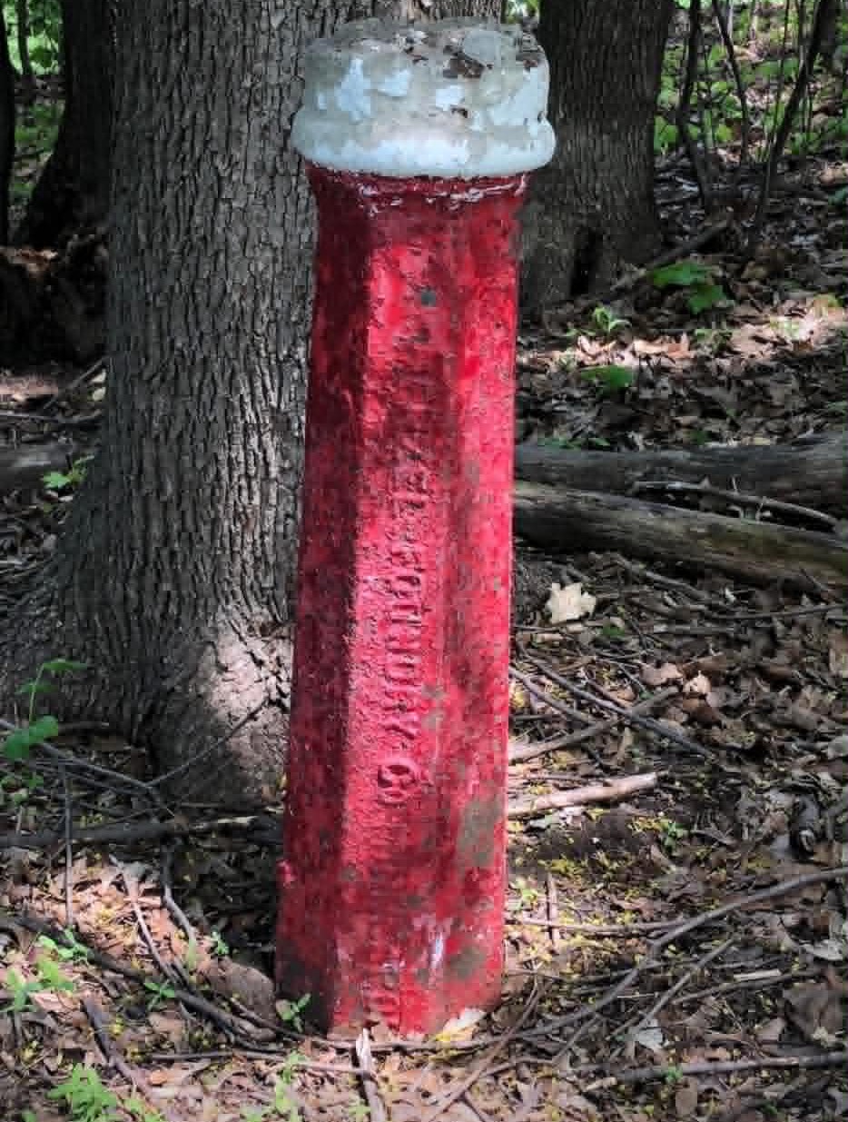
 A reader asked about these red posts with white tops located along William Berry Parkway near Lake Harriet south of the trolley tracks. Two on the east side and one on the west. There are others in the city, too.
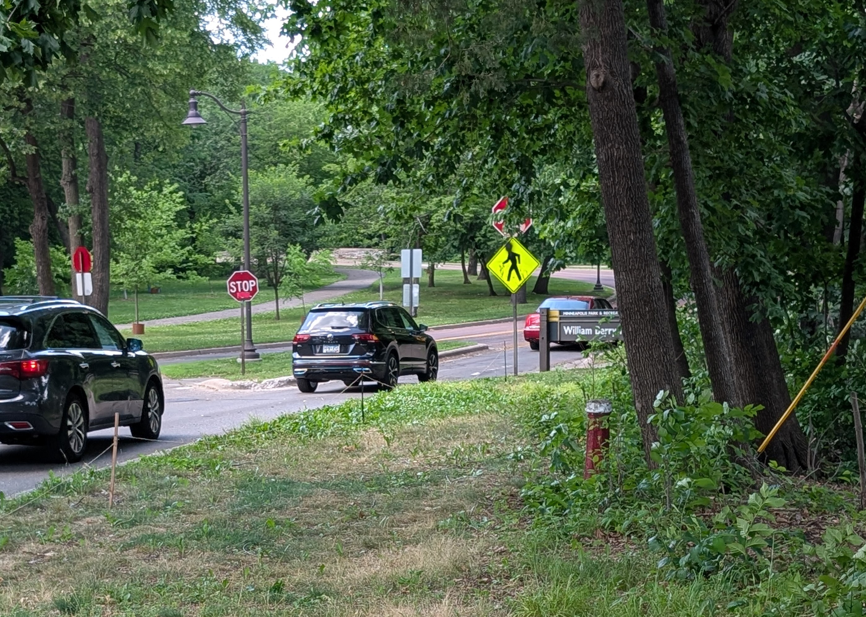
The photo above shows the location of the post near the stop sign leading away from the boat launch parking lot. Another post is across the street to the left.
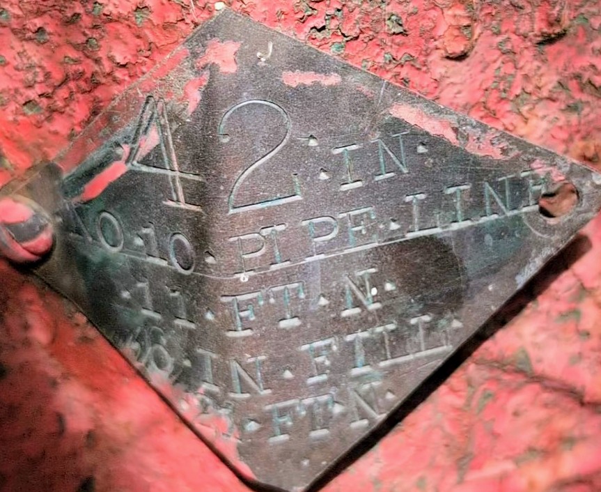
This is the third post which is closer to Lake Harriet and near Lakewood Cemetery’s fence. The cover in the foreground reads “Water Gate” and is likely related. This post has a plate on it that marks a “42 in. No. 10 Pipe Line.” Each of the posts is capped with cement which suggests they may have been vents that are now sealed.
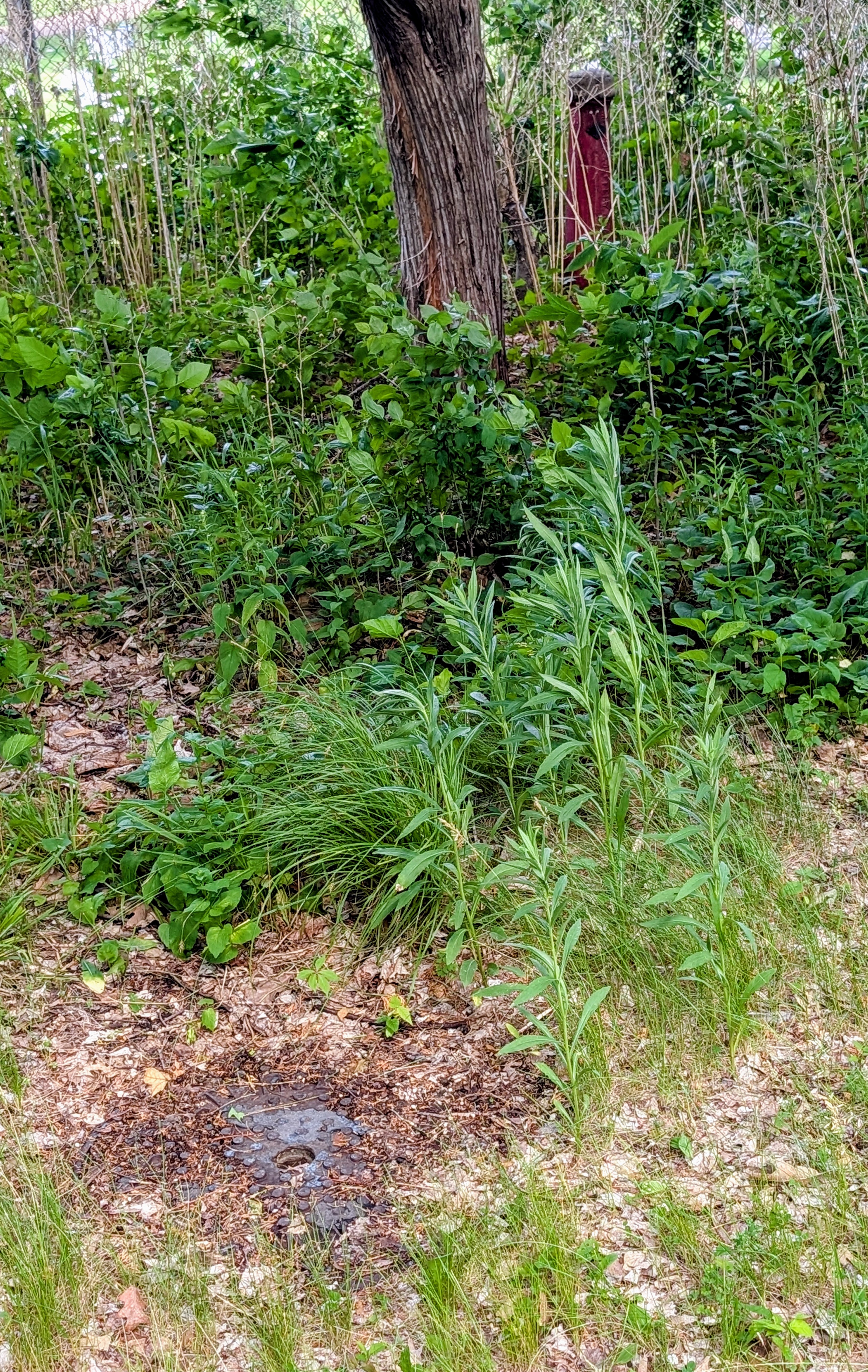
The mystery of the red posts is solved, I believe, by the photo below of another red and white post of sorts taken another 20 yards closer to the lake. I’m a bit puzzled why there is a fire hydrant here as there are no buildings nearby and to my knowledge never have been in this space beween lake, park and cemetery.
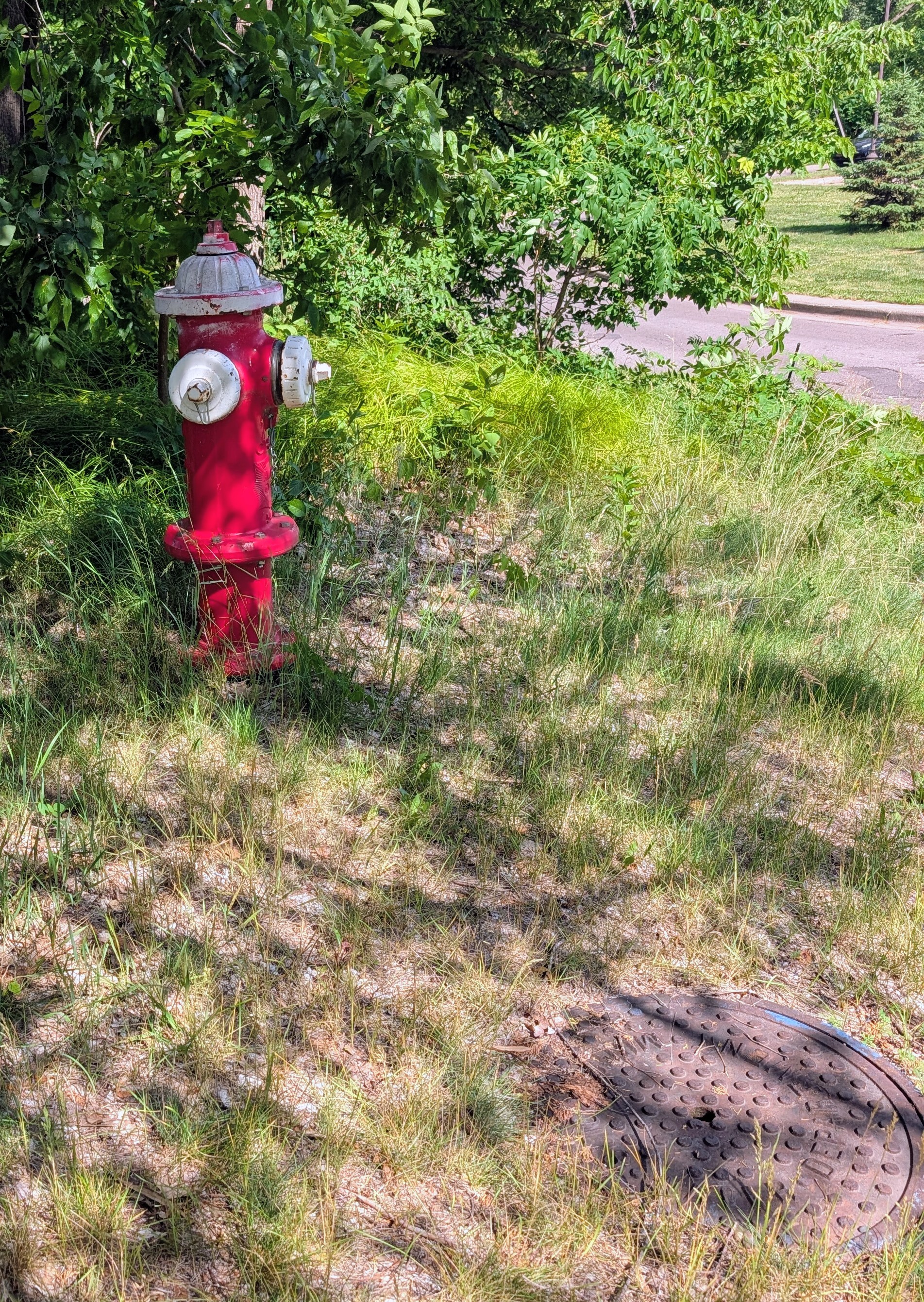
From the placement of the posts it appears that the pipeline may come from the west where there are houses on Queen Avenue and Linden Hills Parkway beyond and it crosses under William Berry Parkway. Why it is placed there however — where it goes — is puzzling. Any explanations?
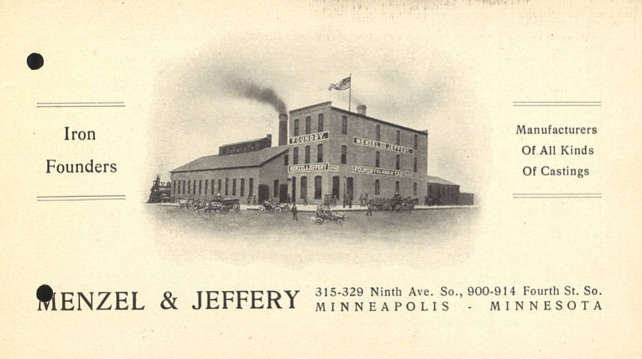
The embossed letters on the side of the posts read, “Menzel & Jeffery,” which was an iron foundry in Minneapolis in the late 1800s and early 20th Century.
Still haven’t heard anything about Eloise Butler’s mystery man mentioned in last post.
David Carpentier Smith
H.W.S. Cleveland: Old New Posts
Filed under: Minneapolis parks | Tags: Bde Maka Ska, Frederick Law Olmsted, H.W.S. Cleveland, Lake Calhoun, Lake Harriet, Theodore Wirth
Leave a comment A few years ago I deleted several posts on this site about Horace William Shaler Cleveland because I intended to use that information in a biography of Cleveland. I have since been distracted from that project and while I still plan to pick it up again, I thought it useful to re-post some of that information about a man who contributed so much to Minneapolis’s quality of life. So for the next few days I will post some of those hidden historical nuggets about Cleveland and his work in Minneapolis parks. I think much of the information I have discovered about Cleveland’s interactions with Frederick Law Olmsted may also be of interest due to the extensive coverage of Olmsted’s work in the past year.
The first “re-post” is from 2010 when I wrote about the history of plans to connect Lake Calhoun to Lake Harriet by a canal. (When I wrote these pieces about Lake Calhoun that was still it’s legal name. It has since been changed to Bde Maka Ska, but I have not edited those articles to reflect the new name.)
Connecting Lake Harriet and Lake Calhoun
David C. Smith
Sharing Streets: An Old Discussion
Filed under: Minneapolis parks | Tags: Edmund Phelps, Grand Rounds, Lake Harriet
Comments (7) The lively continuting discussion of the use of Minneapolis streets and parkways by bicycles, pedestrians and cars reminds me of something I wrote on these pages about six years ago.
That post—100 Years of Engines, Wheels and Metropolitan Parks—addressed the coming of cars to Minneapolis parkways and the increasing importance of automobiles, with a comment on bicyles and horses on parkways, too.

This is one of my favorite park photos. It shows bicycle paths around Lake Harriet in 1896. Notice that the layout of walking path, bicycle path and carriage way, there were no cars yet, is almost identical to today. (Minneapolis Park and Recreation Board)
I regret that we don’t have the “Greater Grand Rounds” that Edmund Phelps (for whom Phelps Park was named) and many others advocated in the early 1900s—one long parkway from White Bear Lake to Lake Minnetonka and along the Minnesota River as well as the Mississippi. Still, what we have is not bad.
David C. Smith
Linden Hills Boulevard: The Carriage Route to Lake Harriet
Filed under: Minneapolis Parks: General | Tags: Lake Calhoun, Lake Harriet, Linden Hills Boulevard
Comments (6) At a recent picnic with friends who live south of Lake Harriet (Happy Birthday Kathryn!), they were surprised when I told them that the first park connection between Lake Calhoun and Lake Harriet was not William Berry Parkway (which was named Shady Lane until 1968), but Linden Hills Boulevard. The boulevard was conceived as a scenic approach on the ridge overlooking Lake Harriet and the final link from Central (Loring) Park via Kenwood Parkway to Lake of the Isles, around that shoreline and the eastern shore of Lake Calhoun to Lake Harriet.
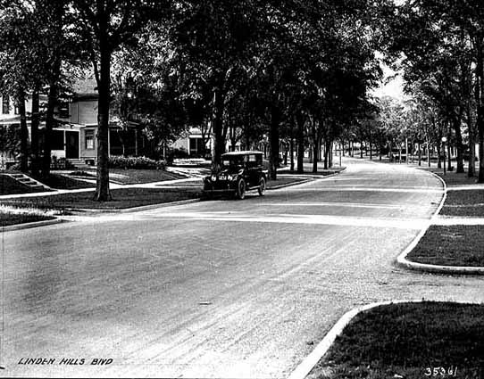
Freshly paved Linden Hills Boulevard in 1921. (Minnesota Historical Society, MH5.9 MP2.2 p31.)
Given the recent interest expressed in the boulevard, I am posting a brief history of the parkway I had written originally for the Park Board website (minneapolisparks.org).
Location: William Berry Parkway to Queen Avenue at West Lake Harriet Parkway
Size: 5.71 acres
Name: The land was referred to as Park Boulevard in park board documents for about 25 years until it was officially named Linden Hills Boulevard, after the surrounding neighborhood, in 1912.
Acquisition and Development: From the first time that Linden Hills Boulevard was included as a separate item in the park board’s inventory in 1914, it was described as having been donated by Henry Beard in 1888. However in 1888, the board paid $8,342 for “satisfaction of Beard contract” which included two years and three months worth of interest on an original amount of $7,200 that the park board owed him. It is unclear what land is referred to in the “Beard contract.” It could include portions of the Lake Harriet shore as well as Beard Plaisance or Linden Hills Boulevard. Beard was one of the original donors of the land around Lake Harriet for park purposes.
Park Boulevard was created to link Lake Calhoun to Lake Harriet. Using the math from the report on the Beard contract, the original deal to acquire the land dated to 1886. The boulevard was intended to be the primary connection between the two lakes until a more direct route between the lakes, eventually named William Berry Parkway, was acquired in 1889.
The boulevard was graded and planted in 1889. In the park board’s 1889 annual report, Charles Loring describes it as the “high land west of the Motor track, overlooking the lake.” At that time there were no homes between the boulevard and the lake. The Motor track Loring referred to was the street railway track. The initial layout of the boulevard was a 40-foot-wide driveway flanked by 10-foot-wide walkways and 20-foot-wide planting spaces, which were covered with loam and seeded.
The first homes on the boulevard were not built for a few years after initial improvements were made. The oldest existing homes along the boulevard, built in 1894, include the house at the corner of 40th St. West and 4208 Linden Hills Boulevard according to Hennepin County’s Interactive property map. A house between the Boulevard and Lake Harriet was built at 4236 Queen Avenue in 1897. The rest of the houses on Queen Avenue and the Boulevard were built in 1900 or later. (Additional research in February 2022 by the other David C. Smith and the Linden Hills History Study Group reveals that building permits were taken out in 1894 also for houses at 4200, 4220 and 4228 Linden Hills Boulevard, all on the west side of the boulevard, and for 4224 Queen Avenue South between the boulevard and the lake. Those four houses are listed on the interactive map as built in 1900.)
Original improvements to the Boulevard in 1889 also included a 70-foot viaduct at the end of the boulevard over the street railway tracks at Queen Avenue. The total cost of the improvements was nearly $7,000. The street railway rebuilt the Queen Avenue bridge in 1905 following extensive negotiations with the park board over who was responsible for it. The park board refused to repair the bridge, because it believed the street railway was responsible.
The Linden Hills Boulevard was improved significantly in 1912 at a cost of nearly $5,000 even though it was no longer the main link from Calhoun to Harriet. With the improvements that year came pressure for a more suitable name than Park Boulevard. The board chose the name Linden Hills Boulevard.
The boulevard was paved for the first time in 1921. The entire length of the parkway was repaved in 1993.
Most of the parkways in Minneapolis were officially named “boulevards” until 1968 when they were all renamed “parkways” to indicate more clearly that they were park property. (They were also later paved with a distinctive red-tinted asphalt to further distinguish them from ordinary city streets.) However, Linden Hills Boulevard was overlooked at the time and is, therefore, the only road owned by the park board still officially called a boulevard—even though it, too, is paved red.
David C. Smith
Dancing with the Fishes
Filed under: Lake Harriet, Minneapolis Parks: General | Tags: Lake Harriet, Lake Harriet Pavilion
Leave a comment Recent news about the discovery of a zebra mussel in Lake Harriet prompted a flurry of activity at the lake to see if more could be found. Thankfully, after nearly 70 hours of searching, no more of the striped invaders were located. Some of that searching was done by divers who filmed their searches.
Although they found no more mussels, what they did find is a bit of a mystery. You can view their discovery on YouTube here. Thanks to MaryLynn Pulscher at the Park Board for the link.
The divers speculated that what they found was a dance floor from one of the old pavilions at the lake. It is entirely possible that what they found was a remnant of an old pavilion, although I have serious doubts if it was dance floor because dancing was frowned on by a significant portion of society in early park history. I’m not aware of dancing at any of the Lake Harriet pavilions. (When the first recreation center was built at Logan Park in 1913, there was angry opposition to it by those who didn’t want any kind of dances held in their neighborhood. To appease them, the Park Board limited the type and frequency of dances that were permitted.)
The first pavilion constructed at water’s edge burned down in 1903. Perhaps part of that wreckage was simply pushed into the lake. I’ve never seen photos or read descriptions of how any remains of that fire were disposed.

First pavilion built on the Lake Harriet shoreline in 1892. The pavilion was designed by Harry Wild Jones. It burned down in 1903. (Minnesota Historical Society)
Another possibility is that when the succeeding pavilion, which extended into the lake, was destroyed by a tornado in 1925, part of the pavilion was blown into the lake and never retrieved.

The new Lake Harriet pavilion, also designed by Harry Wild Jones, and boat dock in 1905. The bandstand seen here on top of the pavilion lasted only one year due to terrible acoustics. It was moved to the east side of the lake at 46th Street where it served as an overlook or “belvidere”.
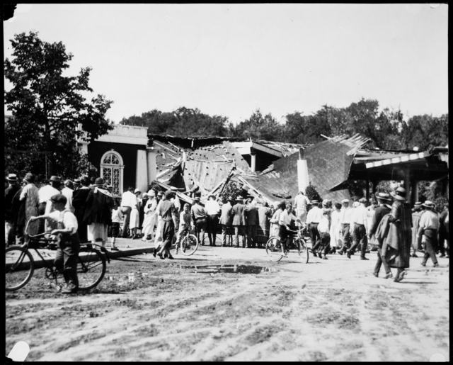
A storm destroyed the Lake Harriet Pavilion in 1925, resulting in two deaths. (Minnesota Historical Society)

This photo was taken very shortly after the Lake Harriet pavilion was destroyed in 1925. It’s the only photo I’ve seen of Lake Harriet without a pavilion. A pile of rubble marks the spot where the pavilion once stood. Did some of that rubble remain in the lake? Or were these extensive boat docks eventually dismantled and scuttled in the lake? (David C. Smith)
The second pavilion designed by Jones, which extended into the lake, was also rearranged in 1912 and 1913 because it had become unsafe for the large crowds that listened to concerts on the rooftop. The pilings under the pavilion were replaced in 1912 and the pavilion was extensively remodeled. Perhaps debris was left in the lake when that work was concluded. Another possibility could be that a portion of one of the two floating band shells that were used in the early history of Lake Harriet entertainment were sunk there.
If the remains found on the bottom of Lake Harriet near the shore were just wood, however, why did they sink instead of floating to shore? It’s hard to imagine someone like park superintendent Theodore Wirth, who served in that capacity 1906-1935, permitting something as unsightly as pavilion wreckage to bob around in one of his lakes until it sank.
I would welcome speculation from our many knowledgable readers on what that wreckage on the bottom of Lake Harriet could be and how it got there.
Before leaving the subject, I want to express my support and gratitude to the park commissioners and staff who have kept our lakes mussel-free for this long and to encourage boat owners to exercise extreme caution when putting their craft into city lakes. I hope the lone zebra mussel found was an anomaly — as it appears to be.
David C. Smith
Charles Loring: “We must control the lake.”
Filed under: Loring Park, Minneapolis Lakes, Minneapolis parks | Tags: Charles M. Loring, Florence Barton Loring, Lake Calhoun, Lake Harriet, Lake of the Isles, Minneapolis parks, Minnehaha Falls
Comments (3) If you have read my history of the Minneapolis park system, City of Parks, you may recall that Charles Loring’s efforts to acquire land around lakes Harriet, Isles and Calhoun remain a subject of speculation. No one has ever found a clear strategy or well-documented plan by Loring, the first president of the Minneapolis Board of Park Commissioners, to acquire the lakes, even though he spent the better part of several years in getting those complicated real estate deals done. I focused mostly on Loring’s desire to create a parkway from Loring Park, then still called Central Park, around the lakes to Lake Harriet, which had been acquired already for the fledgling park board largely by gift. Even the generous gift of land around Lake Harriet by Henry Beard, James Merritt, Charles Reeve and, ultimately, William King, was prompted by the desire to have a parkway around the lake, which accounts for the limits of the original gift: a strip of land only 125 feet wide around Lake Harriet—just enough for a walking path, a carriage way and a few trees or flowers to dress it up.
A new discovery suggests, however, that Loring had much more in mind than parkways. As part of the ongoing project to inventory the park board’s historical records with the goal of making them more accessible to researchers, I recently found a letter written by Loring in 1886 that sheds more light on his thinking about the lakes.
The letter, dated June 14, 1886 and addressed to park board secretary Rufus Baldwin, discusses Loring’s views on what needs to be done to acquire land at Lake of the Isles. Loring notes that Alfred Dean, who owned much of the land that had to be crossed by a parkway at Lake of the Isles, had already told Loring he could do whatever he wished. Loring then wrote,
“My opinion is that we do not want the land on the outside, but do want it next the lake. As the plat now is, the boulevard goes around the little marsh thus.”
Loring then includes a small drawing.
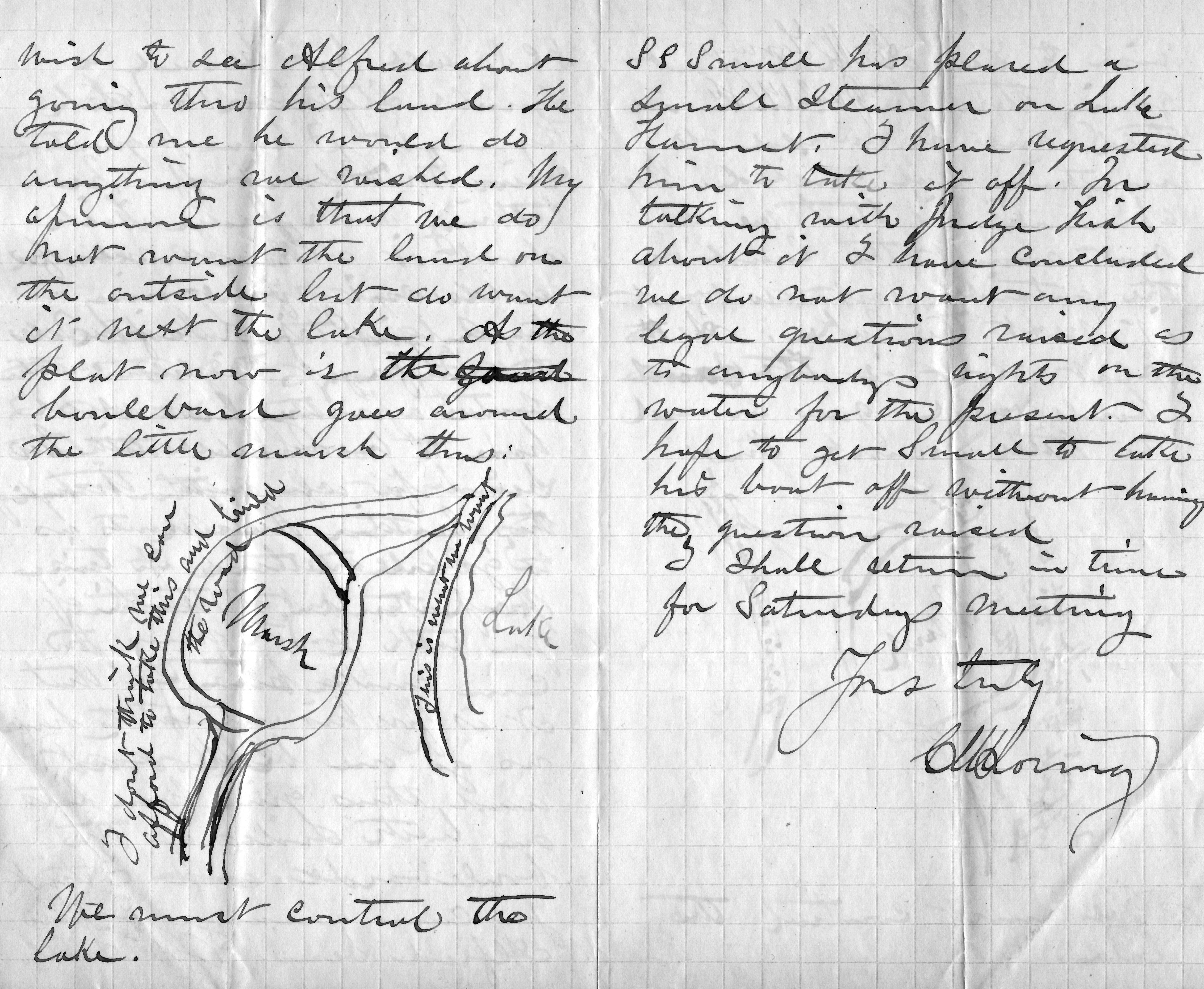
Charles Loring’s letter to Rufus Baldwin, June 14, 1886
He is very explicit, writing on the road next to the lake “This is what we want” and concluding bluntly, “We must control the lake.”
This evidence that Loring was thinking far beyond parkways is reinforced by the concluding page of his letter when he addresses a new topic: boats on Lake Harriet. He notes that a steamer has been placed on the lake and he has asked the owner to remove it, but adds that after talking with “Judge Fish”—park board attorney Daniel Fish—Loring doesn’t want legal questions raised yet about “rights on the water”. Clearly, Loring is thinking about park board control not just of boulevards around the lake, but activity on the lake as well. His earlier comment, “We must control the lake”, takes on even greater significance.
We may owe even more to Charles Loring and his vision than we previously knew.
While on the subject of Loring I want to mention a note I received a while ago from, William Scott, the great-great-nephew of Charles Loring’s second wife Florence Barton Loring. You can read more about his family’s relationship with the Bartons and Lorings in the “Comments” section here.
This is the carte de visite of Florence Barton that he refers to. Thanks to William Scott for sharing the photos below.

Florence Barton, date unknown. (Beal Art Gallery, Harold W. Scott Collection, courtesy William Scott)
This must have been taken long before she married Charles Loring at age 45 in 1895. Read much more about Florence Barton Loring here.
William Scott also sent a photograph of family and friends at Minnehaha Falls in about 1910. Love those hats! The new bridge with the boulder face over a concrete structure was brand new in 1910. Appears to be a dry year.

David C. Smith
© 2016 David C. Smith
Something’s Missing at Lake Harriet
After my post yesterday of Margaret Hall’s letter and a Minnesota Historical Society photo of the tornado-damaged pavilion at Lake Harriet in 1925, I dug out my favorite Lake Harriet photo of all time. Notice what’s missing?
No pavilion!
This photo was taken very shortly after the Lake Harriet pavilion was destroyed. It’s the only photo I’ve seen of Lake Harriet’s north shore without a pavilion. A “temporary” replacement band stand was built the next summer so concerts could continue at the lake. That small band stand stood for 60 years.
A pile of rubble marks the spot in this photo where the pavilion once stood. It’s unlikely that a man as insistent upon beauty and efficiency as park superintendent Theodore Wirth would have allowed the rubble to remain for long, so this photo must have been taken in the few days after the storm in mid-July. Surprisingly, the storm appears not to have damaged the boat docks or boats, lending credence to claims that the pavilion was destroyed by a tornado, not straight-line winds.
Like many others who have developed an interest in local history, I have begun searching for photos that reveal more of the history of a place than one can find in written accounts. One of the best places to find photos — of a certain era — is on postcards. This photo comes from a vintage postcard I purchased. There is no attribution of the photo on the card. It was never mailed, although it was quite beat up. I cropped the creases and stains on the edges of this postcard.
If you have a favorite, non-commercial image of Minneapolis, especially parks, send me a scan or print and I’ll post it here. Please identify the photographer if at all possible.
David C. Smith
Memories of Lake Harriet
Filed under: Minneapolis Lakes, Minneapolis Park Memory, Minneapolis parks | Tags: Lake Harriet, Lake Harriet Pavilion, Lyndale Farmstead, Lyndale Park
Comments (8) The following letter, dated July 9, 2014, was addressed to the Minneapolis Park and Recreation Board:
On July 4, 2014 my daughter sent me pictures of two of my great grandsons enjoying the holiday at Lake Harriet. I recently celebrated my 95th birthday and those pictures brought a deluge of memories to me. My two sisters and I grew up on Bryant Ave. So. in the 4100 block, just a few blocks from Lake Harriet, Lyndale Park and Lyndale Farmstead.
One of my early memories is from the early 1920s when dinners were served in the old pavilion where the modern band shell now stands. It was July 8, 1925 and my father decided it looked too stormy to go to dinner at the pavilion. That evening a tornado struck the area and the pavilion was devastated. Several lives were lost when the pavilion collapsed. I was 6 years old but I remember walking around the lake several days later and seeing the damage to the trees and the lake shore.
A storm destroyed the Lake Harriet Pavilion in 1925, resulting in two deaths. (Minnesota Historical Society)
There is no continuity to these memories as I write them down. Walking to the lake in the early spring and the scent and beauty of the lilacs along King’s Highway. The rose garden in summer which still looked the same in the pictures with the boys. The walk through the woods on the bridle path with the sounds and sights of the birds in the bird sanctuary.
The many picnics we had as a family by the lake and the band concerts that climaxed the day. The salt-water taffy, popcorn and balloons, the walk home along the lake shore through the park where it seemed there were always fire flies lighting our way. Often we left before the end of the concert and if the wind was right, we could hear the band playing the Star Spangled Banner and we knew the concert was over. All summer we swam at the 48th Street beach
I also recall when the launch on Lake Harriet was part of the Minneapolis Street Car Company and made stops at the docks at Penn. Ave., Morgan Ave., 48th Street and 43rd Street. We enjoyed coming from downtown on the Oak Harriet line and transferring to the launch at the pavilion for a cool ride home on a hot summer day, and a short walk home from the 43rd Street dock.
In the winter our sleds were on the easy slopes in the park adjacent to the rose garden. When we grew older, we advanced to Lyndale Farmstead and dared to slide on King’s Hill. At that park we skated all winter, played tennis in the summer and enjoyed the chrysanthemum gardens in the fall.
Another memory of Lyndale Park was the annual pageant with acts from every park in the city. The pageant was magic in the eyes of children.
Over the years I have made many trips back to the Bryant Ave. home. My mother and I would walk around the lake and my children and grandchildren would enjoy the same things I did as a child.
Theodore Wirth’s dream of a park within 6 blocks of every home in Minneapolis has been perpetuated and I, at 95, can from my home in Alaska live these memories.
Margaret J. Hall, Kodiak, Alaska
Note: I was given this letter recently at a meeting at the park board, so I wrote to Ms. Hall to ask her permission to reprint it here. Because the letter was nearly a year old and Ms. Hall was 95 when she wrote it, I wasn’t sure if I would get a response. I was delighted to receive a letter from her this morning granting permission to publish her letter.
She added:
When I got your letter I went to my computer and looked at your blog. (Yes, I do have a computer, but I still prefer letter writing.) More memories immediately came. My letter only included the parks within walking distance of our home and didn’t include the street car rides to Minnehaha Park and all its magic, Sunday rides to Loring Park, and to Powderhorn Park for the fireworks.
As I approach my 96th birthday on June 15th, I think of an ideal celebration: a picnic at Lake Harriet, a ride on the launch, and a band concert in the evening.
Thanks for sharing your memories with us, Margaret. So much has changed in the last century, yet some things endure.
David C. Smith
Two New Park-Related Books by Joe Bissen and Sue Leaf
Filed under: Minneapolis Parks: General | Tags: Bryn Mawr, Camden Park, James Ford Bell Museum of Natural History, Joe Bissen, Lake Harriet, Lyndale Park, Minneapolis golf, Sue Leaf, Thomas Sadler Roberts
Comments (1) I’m happy to recommend two books that I’ve recently added to my shelves on Minneapolis history.
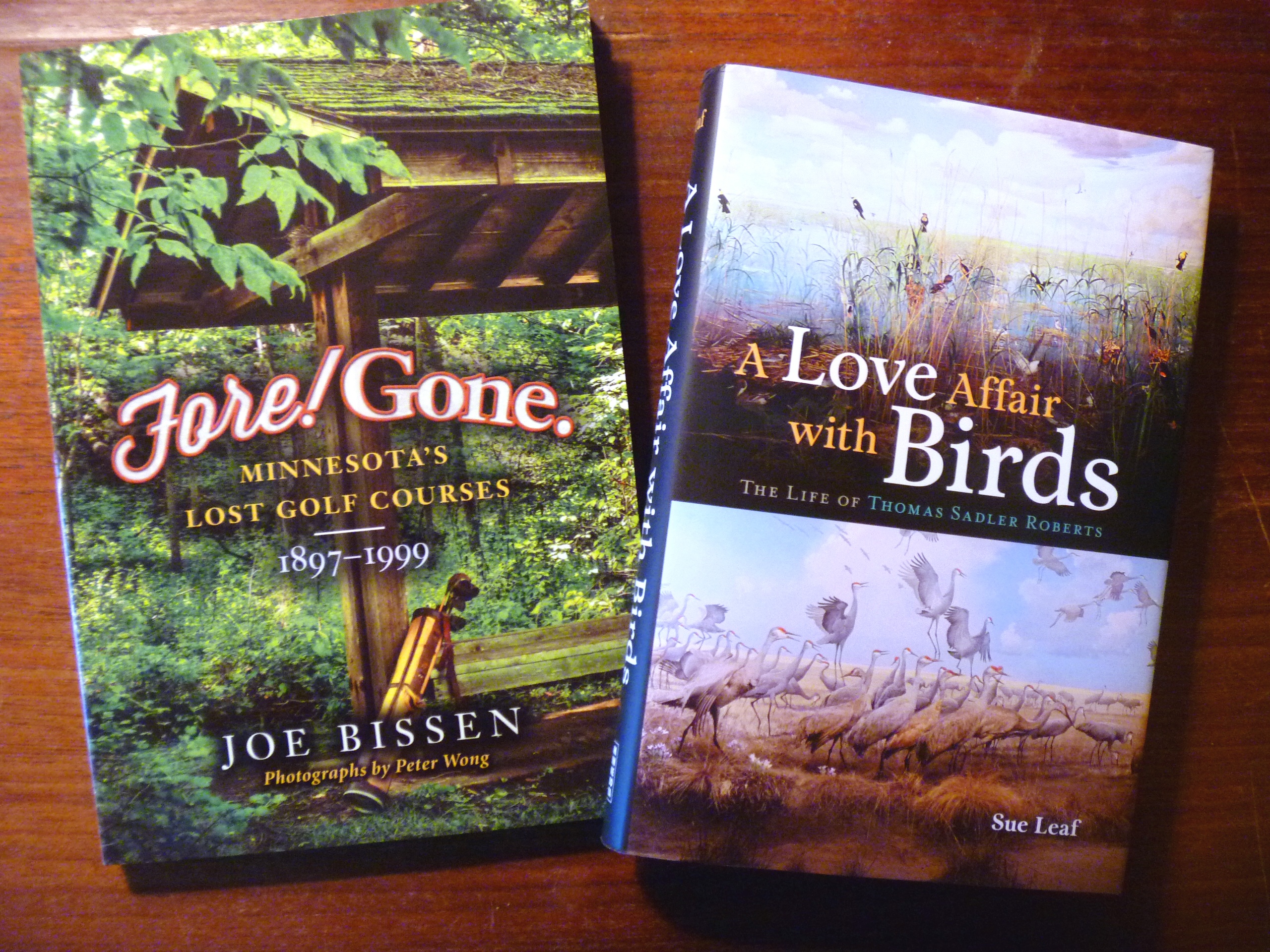
Two recent additions to my Minnesota history book shelves.
Fore! Gone. Minnesota’s Lost Golf Courses 1897-1999 by Joe Bissen. Joe contacted me after reading my pieces on the old Bryn Mawr Golf Club before it spun off Minikahda and then Interlachen. We ended up spending an enjoyable morning roaming around the Bryn Mawr neighborhood trying to pin down the location of the course and the clubhouse. It was a task made more difficult by the changes in street names and house numbering systems over the last 115 years. Bryn Mawr is only one of many long-gone golf courses that Bissen writes about in this entertaining book. If you’ve played much golf in the state, you’ll find these stories especially enjoyable, but you needn’t be a fan of “a good walk spoiled” to enjoy these stories of changing landscapes.
For Minneapolis history buffs, I’d recommend a visit to Joe’s blog as well, where he goes into greater detail on his search for more info on the ancient Camden Park Golf Club that was supposedly built around Shingle Creek by employees of C.A. Smith’s lumber company.
A Love Affair with Birds: The Life of Thomas Sadler Roberts, by Sue Leaf. The wild landscape north of Lake Harriet, which is named for Thomas Sadler Roberts, is widely known as a bird sanctuary in the Minneapolis park system. What is probably less-well known, is that the entire Minneapolis park system is a bird refuge — and has been for about 75 years. Roberts was a doctor and later in life an ornithologist at the University of Minnesota who was instrumental in creating the fabulous displays at the Bell Museum of Natural History at the U.
When I was still in grade school in the 1960s I remember my parents taking us to see those displays on Sunday afternoons. I don’t think they are as heavily visited now as they once were, but I had such fond memories of those life-like exhibits that I took my daughter there several times in this century. A couple of years ago I included in this blog a photo of wolves attacking a moose outside the museum.
Now, thanks to author Sue Leaf, I know the story of how the Bell Museum came into existence — as well as many other details of the life of a remarkable man. Leaf places Roberts’ life in the context of the early history of Minneapolis. His friends, colleagues and benefactors included many influential people in the creation of the city’s economy and institutions.
The story Leaf tells heightens appreciation for the wildlife habitat that Minneapolis parks have preserved not only in the Thomas Sadler Roberts Bird Sanctuary, but throughout the park system.
I hope you will keep both books in mind for your book-inclined friends and family this gift-giving season. Or buy one for yourself and save it for a day when you’re snowed in. Sorry, but you know it’s coming.
David C. Smith
Post script: Check back in a couple days and perhaps you can help us solve a mystery in Thomas Sadler Roberts Bird Sanctuary.
© 2014 David C. Smith
Lake Harriet: The Heart of the Minneapolis Park System
Filed under: Lake Harriet, Lyndale Park, Minneapolis parks | Tags: H.W.S. Cleveland, Horace Cleveland, Lake Harriet, Lake Harriet Pavilion, Lyndale Park, William Berry Park
Comments (2) NOTE: The following outline and photos introduce the important role of Lake Harriet in the creation and growth of the Minneapolis park system. While much of this information is familiar to Minneapolis residents, I prepared this presentation for students visiting Minneapolis today from University of Wisconsin Eau Claire. I thought other readers of minneapolisparkhistory.com might enjoy the images and information as well. For more in-depth info visit the history pages of the Minneapolis Park and Recreation Board. For a more complete picture of the parks surrounding Lake Harriet see the history of Lake Harriet, but also of William Berry Park and Lyndale Park.
If the prized Minneapolis park system were a living thing, Lake Harriet would be its heart. The Grand Rounds — 60 miles of parkways threaded through the city — would be the rest of the circulatory system of veins and arteries. The analogy holds more for the creation of the park system, with parkways radiating out from Lake Harriet and back, than for the current function of Lake Harriet in the system.
Lake Harriet and Lake Calhoun had always been primary targets of people in Minneapolis and St. Anthony who believed the growing towns needed parks. For decades, residents of the small towns beside St. Anthony Falls had taken Sunday excursions to the shores of the lakes for picnics and relaxation. As early as 1869, the Board of Trade, a chamber-of-commerce type organization, had voted to acquire the shores of Lake Calhoun for a “pleasure drive” and had secured commitments from all landowners around the lake except one to donate their shoreline for that purpose. That one unnamed holdout must have torpedoed the entire plan.
When the Minneapolis park board was created by an act of the Minnesota Legislature and ratified by Minneapolis voters in 1883, it was well-understood that the lakes would become part of a new park system. Proof was easy: the legislature expanded the city limits of Minneapolis to include Lake Harriet at the same time it created the park board. One went with the other.
One of the park board’s first acts was to hire landscape architect and park advocate H. W. S. Cleveland to advise the board on the creation of parks. About a month later Cleveland presented his “Suggestions” to the broad for a new park system featuring interconnected parkways rather than just a couple large parks. The map that accompanied his suggestions, below, shows in red the parkways he recommended. Note that only Lake Harriet is fully encircled by parkway, the “heart” of this circulatory system.

Horace Cleveland proposed this system of parks and parkways in 1883. (Minneapolis Park and Recreation Board)
The map provided a blueprint for a park system that the park board tried to implement. Although the board failed to acquire many of the specific routes proposed by Cleveland — and added others — the concept of a system of parkways encircling the city eventually became the Grand Rounds parkway system of today.
Cleveland used another anatomical metaphor in the park system he proposed that focused on what was most important to him. He called the Mississippi River gorge and parkways on both sides the “lungs” of the city. He meant that a corridor of green on both sides of the river — the “jewel” of the city — would provide a flow of fresh air through the city north to south, which would help prevent pollution and disease. It was not a coinage that originated with Cleveland, but had been used to advocate city parks in the dense and squalid urban cores of Paris and London since early in the century.
In fact, however, the Grand Rounds parkway system had its start at Lake Harriet and the rest of the parkways followed. It was the first parkway the park board attempted to acquire. A first appraisal of the shores of the lake put the cost at $300,000, much more than the park board could legally spend. Then landowners Henry Beard, Charles Reeve and James Merritt approached park board president Charles Loring with an offer: they would donate to the park board a strip of land 125 feet wide that nearly encircled the lake. The park board gratefully accepted that offer in 1885. (Ownership of a portion of that land was being contested at the time in court and a court ruling returned much of the land to William S. King, then a park commissioner. He honored the deal already struck with the other landowners and the park board owned a strip of land for a parkway around most of the lake.)
The park board’s other parkway projects revolved primarily around creating routes from other parts of Minneapolis to Lake Harriet. Hennepin Avenue was acquired to be a parkway connection from Central (Loring) Park to Lake Harriet. But when heavy traffic on that road dimmed its prospects for ever being a parkway, an alternative route to Harriet was found. Land was donated for Kenwood Parkway from Central Park to Lake of the Isles, then around Lake of the Isles, which hadn’t figured at all in Cleveland’s plan, to Lake Calhoun. The park board purchased the eastern shore of Lake Calhoun, at what Loring considered an exorbitant but necessary price, to reach the southern tip of Lake Calhoun. From there, Linden Hills Boulevard, also acquired from Henry Beard, would carry traffic to Lake Harriet.
Cleveland conceived of another major circulatory connection to Lake Harriet as a parkway east from Lake Harriet to the Mississippi River. He envisioned that to be Lake Street, but that thoroughfare already was home to a concentration of businesses that made it too expensive to acquire. The route east from Harriet that later emerged, largely due to free land, was Minnehaha Creek. Although much farther south and far from the central city neighborhoods that Cleveland thought would need a parkway, Minnehaha Parkway became the park connection to Minnehaha Falls and the river parkways.
Even the parkways from the Lake District into north Minneapolis were really arteries directly from the north side to Lake Harriet. When it became evident that Lyndale Avenue could not be converted into a parkway from Central Park north, the park board looked to the west to connect Lake Harriet via Cedar Lake and what eventually became Theodore Wirth Park and Parkway to north Minneapolis. Once again the appeal, at first, was the prospect of free land along that route from William McNair, a friend of the parks and several park commissioners.
Further supporting the Lake Harriet-as-heart metaphor is that the northern half of the Grand Rounds was inspired by what had already occurred in the southern half of the city connecting lakes, river, and creek to Lake Harriet. William Folwell, former University of Minnesota president, park commissioner and Cleveland’s close friend, urged the park board in a special report at the end of 1890 to return to the vision of Cleveland. In his report, he urged the board to resurrect and finish the system of parkways throughout the city that Cleveland had suggested. Folwell even gave that system of parkways, which began and ended at Lake Harriet, a name for the first time: Grand Rounds.
To the Water’s Edge
The parkway at Lake Harriet also established another critical precedent in the history of Minneapolis parks. In keeping with Cleveland’s plan for an interconnected system of parkways, the park board wanted a parkway around the lake instead of just a large park beside it. The parkway acquired encircled the lake on its shoreline. That meant the park board owned the entire lake and it established that precedent for later acquisitions at Lake of Isles, Lake Calhoun, Minnehaha Creek, even the Mississippi River gorge. Nearly everywhere in Minneapolis, the park board owns the water front. The only places that is not true today is the banks of the Mississippi River above the falls, and that is in the process of being acquired piece by piece, and those parts of Bassett’s Creek that had been tunneled below ground even before the park board was created.
The unique and defining feature of Minneapolis today is not only the lakes and creeks and river running through it, but that almost all land abutting those bodies of water is publicly owned and preserved as parkland. We aren’t restricted to a glimpse of water between mansions built on lakeshores; the people own the lake shores. The effect on the prosperity of the city has always been significant. As Minneapolis park board studies have shown, property values are increased not only adjacent to the lakes, creeks and river but up to several blocks away from those amenities because they are publicly owned and freely accessible.
Donation of Land
Another reason for the centrality of Lake Harriet to the development of the Minneapolis park system was the means by which the park board acquired the Lake Harriet shoreline: it was donated. That also established a precedent that Charles Loring, in particular, was very successful in replicating. Loring secured other land donations in the few years after the donations at Lake Harriet by Beard, Reeve, Merritt and King: Kenwood Parkway, most of Lake of the Isles, half of Lake Calhoun, part of Cedar Lake, much of Minnehaha Creek, Stinson Parkway, Lyndale Park and The Parade. Even much of the river gorge was sold to the park board well below market value.
Let Us Entertain You
Lake Harriet was also the heart of park board expansion into new areas, especially providing entertainment and recreation. Entertainment at the lake began at a pavilion built by the street railway company on private land beside the lake, but became one of the most popular destinations in the city after the park board allowed the street railway company to build a pavilion on the shores of the lake in 1892. The park board didn’t provide the entertainment directly, but did exercise considerable control over the types of entertainment the railway company was allowed to present. That entertainment did not always meet the approval of all park commissioners, but it continued because people liked it and turned out by the thousands. It is one of the first examples of the nature of parks being adapted to what people wanted.
The first pavilion built on the Lake Harriet shoreline in 1892. The pavilion was designed by Harry Wild Jones. This view is from the streetcar station in about 1895. (Minnesota Historical Society.)
Another important attraction at the Lake Harriet Pavilion were row boats. One of the donors of land around the lake, Charles Reeve, offered in 1887 to pay the park board $1,000 for the right to rent boats and sell refreshments at the lake. Competitive bidding pushed the price up to $1,250, a large sum in the day, before Reeve gained concession rights. But by 1889 the park board realized it could make a nice profit running the boat and refreshment concessions itself and purchased Reeve’s boats.

The park board’s boats for rent next to the Lake Harriet pavilion in 1895. (Minnesota Historical Society)
When the first lakeside pavilion burned down, it was replaced by another Harry Wild Jones-designed structure that extended into the lake in 1904. At the new pavilion, musical performances took place on the roof. The bandshell pictured had terrible acoustics and was replaced after one year. The bandstand was moved to the east side of the lake at 46th Street as a lookout. The boat rental business continued to thrive. (Minnesota Historical Society)

View from the bandstand on top of the Lake Harriet Pavilion in 1905. Notice how far down the shore the boat dock stretches. A seat on the roof for a concert cost 25 cents. (Minnesota Historical Society)

The crowd at a concert on the pavilion roof in 1912, photographed from the stage. (Charles J. Hibbard, Minnesota Historical Society)
The Bicycle Craze
Active recreation–physical exercise–began at Lake Harriet with boating and canoeing, but then along came the bicycle craze of the 1890s and the park board continued what has become a long tradition of accommodating what people wanted from their parks.
Bicycling was so popular that the park board built a bicycle path around the lake in 1896. So many people rode bicycles to the lake that the park board built an enclosure where people could check their bicycles while they were at the pavilion or renting a boat. It was built to hold 800 bicycles. Soon after, the park board built bicycle trails along Minnehaha Creek as well.
One of my favorite Minneapolis park photos shows the bicycle path around Lake Harriet in 1896. This was the first bicycle path in Minneapolis. The layout of walking path, bicycle path and carriage road is almost identical to today. (Minneapolis Park and Recreation Board)
These are just the beginning of the accommodation of public desires at Lake Harriet and then other park properties. What began at Lake Harriet, like the parkways radiating out from it, quickly extended to other parts of the park system even as new amenities were added at Lake Harriet. From the picnic shelter at Beard Plaisance on the west side of the lake in 1904 to the Rose Garden created on the east side of the lake in 1907, the throngs drawn to the lake were regularly provided new attractions.
David C. Smith
© 2014 David C. Smith
The Worst Idea Ever #8: Power Boat Canal from Minnetonka to Harriet
Filed under: Minneapolis Lakes, Minneapolis Parks: General | Tags: 1911 Minneapolis Civic Celebration, Lake Harriet, Lake Hiawatha, Lake Minnetonka, Lake Nokomis, Minnehaha Creek, Minnehaha Falls
Comments (1) Ok, it wasn’t really a Minneapolis park project, but it still deserves a laugh: Minnehaha Creek converted into a 30-foot-wide power boat canal from Lake Minnetonka to Lake Harriet!

Lake Harriet could have been more like Lake Minnetonka.
Minneapolis was obsessed in the spring of 1911 with the upcoming Civic Celebration during which the channel between Lake Calhoun and Lake of the Isles would be opened. That was a very good thing. Huzzah, huzzah. But the attention it was drawing to the city also focused a lot of eyes on a very bad thing: Minnehaha Creek was nearly dry — in the spring! — which meant almost no water over Minnehaha Falls. Minneapolis could hardly celebrate the opening of the lake connection at the same time it suffered the ignominy of a dry Minnehaha Falls. The many out-of-town visitors anticipated for the celebration would surely want to see both. And let’s face it, a fifty-foot waterfall written about by a Harvard poet, which attracted visitors from around the world was a bit more impressive to most people than a short canal under a busy road and railroad tracks. The Minneapolis PR machine could call the city the “Venice of North America” all it wanted with its new canal, but visitors’ imaginations were still probably fueled more by the images of the famous poet’s noble heathen, beautiful maiden, and “laughing waters.”
The generally accepted solution to the lack of water over Minnehaha Falls was to divert Minnehaha Creek into Lake Amelia (Nokomis), drain Rice Lake (Hiawatha), dam the outlet of the creek from Amelia to create a reservoir, and release the impounded water as needed — perhaps 8 hours a day — to keep a pleasing flow over the falls. Unfortunately, with all the last-minute dredging and bridge-building for the Isles-Calhoun channel, that couldn’t be done in 1911 between April and July 4, when the Civic Celebration would launch.
Into this superheated environment of waterways and self-promotion stepped Albert Graber, according to the Saturday Evening Tribune, May 28, 1911. With the backing of “members of the board of county commissioners, capitalists, attorneys and real estate dealers”, Graber proposed to dredge Minnehaha Creek into a canal 30-feet wide from Lake Minnetonka to Lake Harriet. This would provide not only a water superhighway from Minnetonka to Minneapolis, and boost real estate prices along the creek, but it would also create a much larger water flow in Minnehaha Creek, solving the embarrassment of no laughing water.
“The plan, say the promoters, would enable residents of summer houses on the big lake to have their launches waiting at the town lake.”
Saturday Evening Tribune, May 28, 1911
Sure, there were problems. Not every plan could be perfect. The plan would require dismantling the dam at Gray’s Bay at the head of Minnehaha Creek, which might lower the level of Lake Minnetonka. But Graber and his backers had thought of that. The Minnesota River watershed in the area of St. Bonifacius and Waconia would be diverted into Lake Minnetonka — no problem! — which also solved another bother: it would reduce flooding on the Minnesota River.
The dam at Gray’s Bay had been operated by Hennepin Country since 1897. Many people then and now consider the dam the cause of low water flow in Minnehaha Creek, but the earliest reference I can find to low water in the creek was in 1820, when the soldiers of Fort Snelling wanted to open a mill on Minnehaha Creek, but were forced to move to St. Anthony Falls due to low water. That was even before two intrepid teenagers from the fort discovered that the creek flowed out of a pretty big lake to the west.
Graber estimated that dredging Minnehaha Creek would cost about $4,000 a mile for the nine miles between the two lakes. He and his backers, which included an officer of the Savings Bank of Minneapolis (who presumably had a summer house on the big lake and could put a launch on the town lake), provided assurances that the money to finance the project could be “readily found.”
The Evening Tribune article concluded with an announcement that meetings of those interested in the project would be held in the near future with an eye to beginning work before the end of the summer. Graber noted that his inspection of the project had been, no surprise, “superficial”, but that he would make a thorough report soon to his backers. I can find no evidence that the idea progressed any further.
The Board of Park Commissioners would have had no role in the plan, except, perhaps, allowing power boats to enter and be anchored on Lake Harriet. (I think they would have said no.) Park board ownership of Minnehaha Creek west of Lake Harriet to Edina wasn’t proposed until 1919 and the deal wasn’t done until 1930.
David C. Smith
© 2013 David C. Smith
H.W.S. Cleveland and Lake Harriet
Filed under: Lake Harriet, Landscape Architects, Minneapolis parks | Tags: H.W.S. Cleveland, Horace Cleveland, Lake Harriet
Leave a comment While looking for other things I keep encountering bits of information that deepen my understanding of and appreciation for Horace W. S. Cleveland’s profound contribution to Minneapolis parks.
More than a year before the creation of the Minneapolis park board and Cleveland’s “Suggestions for a System of Parks for the City of Minneapolis” a Minneapolis Tribune editorial, published January 22, 1882, announced “A Prospective Park.” The editorial noted that Philo Remington and Col. Innes, who ran the Minneapolis Lyndale Motor Line, were planning to lay out a park on the shores of Lake Harriet and “may eventually” donate it to the city. The newspaper had high praise for the property.
“It is a natural forest, with hill and dale, and comprises without exception one of the most beautiful bits of woodland scenery that can be found anywhere.”
But it was the following sentence that caught my attention and provided more insight into Cleveland’s influence in the city before the park board.
“Col. Innes has made arrangements with Mr. Cleveland, the celebrated landscape gardener, who laid out Union Park, Chicago, whereby that gentleman will take immediate charge of the work of superintending the laying out of a park that will not only be a credit to the city but an inestimable benefit to our citizens.”
I have found no evidence in Cleveland’s correspondence that he was actually hired for any work at Lake Harriet; he never mentions it. And who knows, Remington and Innes may have been blowing smoke. They had other grand plans that didn’t materialize. But whether they were serious or not about a park at Lake Harriet, the editorial indicates the high regard in which Cleveland was held in the city and the likelihood that, at the very least, he was already being consulted on park matters, especially around the lakes, before the park board existed.
A bit prematurely the Tribune enthused, “Minneapolitans may now congratulate themselves on the fact that a public park, the need of which has so long been felt, will soon be completed for their pleasure and benefit.”
Only a year later, at the next session of the legislature, a bill was passed that created the Minneapolis Board of Park Commissioners. Although Cleveland was never credited with designing any of the parks at Lake Harriet, he likely had considerable influence on how the lake shore was perceived and, later, developed.
Just another small piece of evidence of Cleveland’s immense influence on the Minneapolis park system. And yet his name does not appear on a Minneapolis park property.
David C. Smith
For more on Col. Innes’s plans for Lake Calhoun and Lake Harriet see this entry.
For more on why Cleveland’s name should be connected to the vast park that is the Mississippi River Gorge see this entry and this one, too.
For more on Cleveland in general, search above for his name or click on his name in the tag cloud at right. I’ve written quite a bit about him. Take a closer look at the map from his “Suggestions…” at right, too.

