Archive for the ‘Minnehaha Creek’ Tag
Big Island, Big Book
Filed under: Minneapolis Parks: General | Tags: Big Island, Lake Minnetonka, Minnehaha Creek
 Leave a comment
 Just in time for the history buff on your gift list comes a big book: The History of Big Island, Lake Minnetonka. While the book is richly illustrated with historical photos and drawings, it is much more than a coffee-table book. It appears to be a labor of love by author Paul Maravelas: exhaustively researched, carefully written, and extensively footnoted.

Maravelas covers the entire recorded history of the island–and the lake–drawing from archaeological records, oral histories, journals, letters, newspapers, and official records. He takes the reader through the many purposes the island has served from maple sugar production and wild rice harvesting to farming to amusement park and campsite.
I especially appreciated chapters on what we know of the Dakota use of the island and, years later, the creation of an amusement park on the island and the role played by the streetcar line from Minneapolis. Of course, many of the names that fill accounts of Minneapolis park history pop up in the history of settlement and development at Lake Minnetonka and Big Island, too. As the source of Minnehaha Creek, Lake Minnetonka will always be off interest to many Minneapolitans, although the watershed isn’t the book’s focus.
I would expect everyone who lives at or near the lake would want this book in their library along with all of us city dwellers who appreciate local history and enjoy a good story.
The book is available from Minnetonka Press. Free shipping via USPS media mail is offered on the publisher’s website this month, which is a significant value as the book runs 470 pages and weighs 4 1/2 pounds. As I said: Big Island, Big Book.
David C. Smith
Minnehaha Creek Mystery Solved!
Park board archivist Angela Salisbury writes:
I believe we’ve solved our mystery. In The Story of the W.P.A. in the Minneapolis Parks, Parkways and Playgrounds volume for 1940 (dated Jan 1, 1941), page 24, regarding the Minnehaha Parkway:
“A small limestone shelter was built north of Minnehaha Creek and west of Xerxes Avenue to house the meter for measuring the amount of sewage entering the city sewer system from the Village of Edina. The village supplied the material for this construction and the work was done by a Park Board W.P.A. crew.”
There is an image of the structure on page 25.
These W.P.A. books are really wonderful, and I’m happy to report they are digitized and available online via the Minnesota Digital Library. This volume is here: https://collection.mndigital.org/catalog/p16022coll55:910#?c=&m=&s=&cv=&xywh=-1177%2C0%2C5267%2C3692
Many wonderful images in these volumes!
Thanks, Angela!
David Carpentier Smith
Minnehaha Creek Shed Mystery
Filed under: Minneapolis Parks: General | Tags: Minneapolis parks, Minnehaha Creek, Minnehaha Parkway
Comments (12) Here’s your new mystery. (Sorry for filling up your inbox today, but this issue was just raised by a reader as I was posting other things!)
The structure pictured below is on park land just north of Minnehaha Creek and west of Xerxes Avenue. That’s just after the creek enters Minneapolis from Edina. I’ve seen it before and assumed it was on private land. I’m told it’s not.
Was it built as a lift station, pump building, or clandestine meeting place for rogue park commissioners? Any Phryne Fishers or Endeavour Morses out there? Or just humble historians?
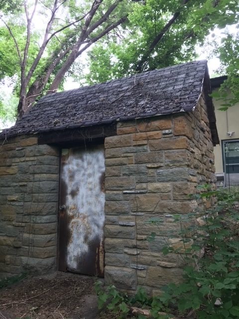

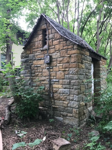
If you know anything, please share. We haven’t found mention of the structure in park records.
David Carpentier Smith
P.S. I think we should have a televised Geraldo-Rivera-style reveal of the inside of the structure. I suspect it was haunted or there were some enormous (yeti?) footprints discovered in the vicinity. Any record of unexplained pulsating blue lights in neighborhood lore? Or perhaps tiny notes left beside tree stumps as elves are wont to leave ala mr. little guy. TPT?
Ironing Out Minnehaha Creek’s Wrinkles
Filed under: Minneapolis parks, Minnehaha Creek, Minnehaha Falls | Tags: Minnehaha Creek
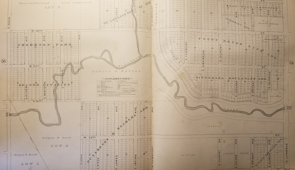
Comments (4) A reader checked in a few weeks ago with a question: Did Minnehaha Creek ever cross West 54th Street in the southwest corner of Minneapolis?
I pulled out my 1903 Minneapolis Real Estate Atlas and was surprised to find that the creek did cross what is now West 54th St. for a few hundred feet. At that time, 54th St. was the southern city limit of Minneapolis.

The park board didn’t acquire this section of Minnehaha Creek — from Humboldt to Zenith — until 1930, and graded and straightened sections of the creek in 1932. The creek would have been straightened here as elsewhere to avoid the expense of building bridges. (Read more about the acquisition and development of this section of Minnehaha Creek. Go to the “History” tab at the bottom of the page.)
The section of Minnehaha Creek acquired in 1930 never had a parkway built along it as was done east of Humboldt. That was partly because some homes had already been built near the creek and also because the creek banks were much steeper here than to the east. But even if it had been perfectly flat and unoccupied, the Great Depression had set in so there was no money for new parkways.
According to Hennepin County property records the first house along this section of W. 54th St. was not built until 1942. That was a rarity because very few houses were built in Hennepin County during World War II due to a shortage of labor and materials. The rest of the houses along the street were built after the war, mostly from 1948 on.
What other changes were made to the course of Minnehaha Creek over the years? Here are three other sections of the creek from the 1903 atlas that you can compare to Google Maps to see what’s changed. Most of the changes were made in the 1920s partly to make it easier to improve the parkway to accommodate car traffic and partly to shorten the course of the creek to try to increase water flow over Minnehaha Falls in drought years — which was most years in the 1920s-1950s. No one seemed to like an empty creek and dry falls.

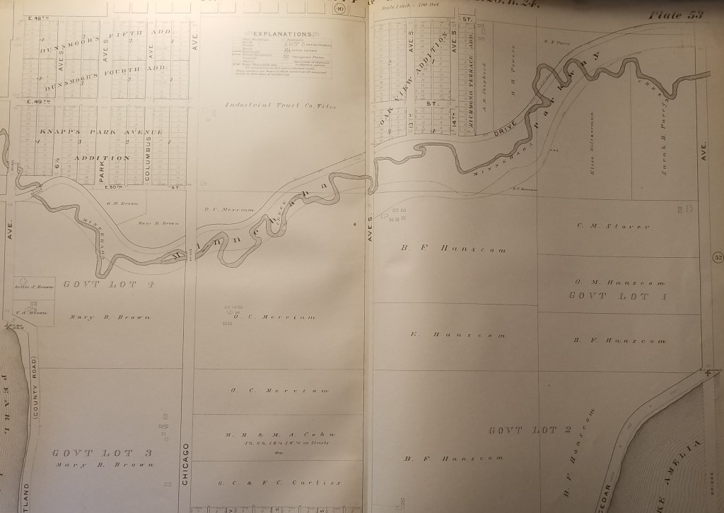
You can view many other early maps of Minneapolis — and spend hours and hours of COVID-avoidance free time — at the University of Minnesota’s John Borchert Map Library website. Countless maps — and aerial photography as well. You’ll be happier and smarter. Stay healthy.
David Carpentier Smith
Lake Hiawatha Water Management
Filed under: Minneapolis Park Board, Minneapolis parks | Tags: Hiawatha Golf Course, Lake Hiawatha, Minnehaha Creek, Theodore Wirth
Comments (3) The Minneapolis Park and Recreation Board (MPRB) recently published background documents on water management issues at Lake Hiawatha and Hiawatha Golf Course that have guided priority-setting and decison-making for the past two years. I would encourage everyone with an interest in the subject to have a look at the papers in the “What’s New” tab at the bottom of the linked page. For many of those most involved in the issue, this review of the project may be redundant, but for many others it will establish a useful starting point for discussion. Even for experts, these documents may provide a good review of the analysis and evaluations upon which park board staff have relied.
What I have not found in those otherwise useful briefings was a recap of historical events to put water levels in perspective. So….here goes. Let’s turn the clock back again. (For more background on the creation of Lake Hiawatha and the adjacent Hiawatha Golf Course and some cool “before” photos, read my recent post Troublesome Lake Hiawatha.)
Lake Depth
Theodore Wirth’s initial plan for dredging Lake Hiawatha was to dredge to a depth of 14 feet. Due to budget concerns, however, he had reduced his dredging plan to a depth of ten feet when contracts were let. In his 1929 annual report (dated January 1, 1930), he wrote that ten feet “as called for in the present contract is the very minimum depth a lake should be, and the only reason for specifying such a minimum depth was to keep the cost…down.” He added, however, that due to money saved through a very competitive bidding process, “it is my earnest recommendation that it be increased to fourteen feet.” His argument was twofold: one, it would produce a “cleaner” sheet of water with less vegetation; two, it would bring the land area to a “higher and more desirable grade at a reasonable cost of $35,000.” That additional four feet of dredging, he noted the next year, had produced an additional 270,000 cubic yards of material.
By the time grading of the new golf course was done, Wirth wrote in his 1932 report that a low lake level and favorable weather had “permitted the creation of much more undulation than hoped for in the great area of level land devoted to the golf course…with the happy result that the eighteen holes will be a more interesting course than it was anticipated could be made.” Had more extensive grading also produced more low areas that could eventually flood?
Lake Level
The lake level used as the average in the contemporary water management study reached via the link at the top of this post is 812.8 ft MSL or above mean sea level. The measurement of levels has changed a few times in the last century. The water levels cited in park board reports from its beginning in 1883 through the time Lake Hiawatha was dredged were in feet above “city datum.” Never mind what that means for a moment. In his 1931 annual report Wirth gives a “normal” elevation of Lake Hiawatha as 100 city datum. To translate city datum measures to contemporary MSL measures requires the addition of roughly 710 ft to the city datum. (If a geodesist finds that I’m off, please let me know a better translation.)
Yikes! That means today’s “normal” of 812.8 ft. MSL is nearly three feet above normal in Wirth’s time of about 810 ft MSL. Take three feet of water off Lake Hiawatha today and most of the golf course and all surrounding neighborhood basements are dry.
But wait, there’s more!
Although 100 was considered the normal level for Lake Hiawatha in 1931 the actual water level that year—the year dredging was finished in a very dry year—was only 96.25! In today’s terms that would be about 806.25 ft MSL, or six-and-a-half feet, roughly one Kawhi Leonard, below today’s normal!
Wirth provided this data in a section of his 1932 report that explained how the park board had contracted with the city to pump city water into the lakes to raise levels. In 1931 the park board paid the city $1,422.25 to pump 113,780,090 gallons of city water into Lake Hiawatha to raise its level to 98.62 ft or roughly 208.62 ft MSL, still four feet below today’s normal! The same year the park board paid the city $3,071.09 to pump 245,687,400 gallons into the Chain of Lakes (Cedar, Isles and Calhoun) and $1,201.19 to pump 96,095,580 gallons into Nokomis.
Why did they do it? Wirth’s words:
“As an experiment to find out definitely how practical and at what cost it would be feasible to raise our lake levels during dry periods, and in order to have the appearance of our lakes in presentable condition for the Knights Templar Conclave in June, together with a desire to have the bathing beaches at certain lakes made available for use…It will be difficult to operate our Lake Calhoun and Lake Nokomis bath houses efficiently with the present elevation of water.”
While noting that given the board’s finances it would be difficult to find the funds to pump water into the lakes in 1933, the Great Depression was grinding people and landscapes to dust, Wirth estimated it would cost $21,762.50 to pump the 1.741 billion gallons of water needed to raise the lakes to normal elevations. (Precision was one of Wirth’s strong suits—as was his compulsion to make his parks “presentable”.) That money was not forthcoming from the park board’s budget, and that year the situation was the “worst in memory,” Wirth wrote. But water was pumped thanks to the city council which had “come to the rescue”.
Not the End
That beneficence was not, of course, the end of water level problems in Minneapolis lakes. By the mid-1950s the situation was so bad that a pipeline was built from Bassett’s Creek to Brownie Lake to pump water into the lakes and ultimately Minnehaha Creek. Unlike Minnehaha Creek, Bassett’s Creek seldom went completely dry. Even that wasn’t a long-term solution. The park board considered a famous hydrologist’s recommendation in the 1960s to capture water from the air conditioners of downtown office buildings to recycle through the lakes. But the owners of those buildings knew a good idea when they heard one and began recycling their air conditioning water back through their own plants. So the park board eventually built a pipeline from the Mississippi River to the lakes, but that failed too when high phosphate levels in river water threatened lake health. So as you can see, through most of park board history the big challenge was how to raise lake levels, not lower them.
Despite the park board’s ownership of the land fronting on lakes and creeks—one of the marvels of the city—we should keep in mind that the park board cannot manage water tables. Has the park board altered shore lines and creek beds? Absolutely. And anytime that is done there can be unintended consequences that can play out over many years. (“Don’t mess with Mother Nature,” some would say! I am presently writing about one of those decisions that still could have very sad consequences.) But water tables, precipitation and run-off (climate change!) are not within the park board’s control—even when, as at present, park commissioners envision a role for the park board in issues outside the purview of historical park and recreation management. And although I am not a hydrologist, it does not seem logical to me that past park board water-shaping efforts—short of building dams, which they did not do except at Longfellow Lakelet and Shingle Creek—could have been the cause of higher water tables across a wide section of the city.
In my opinion, informed by what I know of the history of the area, the groundwater issue is one for which the park board should not take primary responsibility. I think it demands a broader solution that the city or county and state should address—with input from the park board as a significant stakeholder. Just because the easiest place to dump water from south Minneapolis is into property controlled by the park board (Lake Hiawatha) does not make excess water the park board’s unique problem.
The larger issue in this as in so many issues we wrestle with today is the relative weight of individual interests and collective interests. Striking that balance has always been at the core of the American Experiment. Pursuing that line of thinking, I checked when some of the houses now threatened by high water levels were built. Of all those houses that were actually surveyed for the water management study conducted in 2017 for the park board, only one of 28 was built after 1954 according to Hennepin County property records. Nearly half were built before 1932 when the park board finished dredging Lake Hiawatha. In other words, they were built when water levels did not seem to pose a threat.
I hope you will take a closer look at the background information posted by the park board at minneapolisparks.org. I would also encourage you to subscribe to email updates from the park board on the status of plans for Lake Hiawatha and other park areas of interest.
David Carpentier Smith
Accept When Offered: A Brief History of Minnehaha Parkway
Filed under: Minneapolis parks, Minnehaha Creek, Minnehaha Falls | Tags: Charles M. Loring, Horace Cleveland, Minnehaha Creek, Minnehaha Parkway history, Theodore Wirth
Comments (3) Given recent discussion of the history of Minnehaha Parkway, I thought it might be useful to consider a brief timeline of when and why the parkway was acquired by the Minneapolis Board of Park Commissioners and how it was developed. I wrote some of this for the Minneapolis Park and Recreation Board in 2008, but it is not presently accessible at minneapolisparks.org. Most other individual park histories, such as Minnehaha Park, are available there under the “History” tab on each park page. I would encourage you to read them.
Park board records do not reveal the origin of the idea of a parkway along the valley of Minnehaha Creek. The first mention of a park along the creek is in the park board proceedings of October 8, 1887 when, after hearing from “interested parties,” the park board resolved that when lands along Minnehaha Creek “are offered, they be accepted” between Lake Harriet and the Soldier’s Home. (The Soldier’s Home was then planned to be built at the mouth of Minnehaha Creek on the Mississippi River on land donated to the state by the city. Minnehaha Falls was not yet a park, although it was in the works.) As part of the resolution, the park commissioners expressed their intent to create a parkway beside the creek when they deemed best to do so—meaning if they ever had the money.

An early 1900s postcard image of the parkway and path at an unknown location. Don’t you want to follow that path? It’s a favorite image I included in City of Parks: The Story of Minneapolis Parks
Today Minnehaha Parkway begins at Lake Harriet Parkway on the south shore of Lake Harriet and Continue reading
Shared History: Edina’s Early Days
Filed under: Lake Harriet, Landscape Architects, Minneapolis Parks: General, Minnehaha Creek | Tags: Edina History, H.W.S. Cleveland, Horace Cleveland, Minnehaha Creek
Comments (4) Edina and Minneapolis share more than France Avenue—and history buffs aren’t restricted by city boundaries.
Henry Brown played an important role in the history of Edina as well as the history of Minnehaha Falls as a Minneapolis park.
There is a Chowen Park in both Edina and Minneapolis.
Minnehaha Creek flows through Minneapolis parkland before it gets to Edina — and, of course, all of Minnehaha Creek after it leaves Edina on its way through Minneapolis to Minnehaha Falls and the Mississippi River is parkland.
The Interlachen neighborhood grew up around a golf course created by golfers who had outgrown their nine-hole Bryn Mawr course near downtown Minneapolis.
That’s just a taste of the rich information on Edina history—and Minneapolis history— on the web site of realtor Ben Ganje. Go to the neighborhood directory on his site then look at the right margin for a list of Edina neighborhoods. Each of Edina’s 45 official neighborhoods is profiled with historical info and interesting bits of trivia.
I read about Todd Park because of my interest in famous diva Emma Abbott, a Minneapolis girl made good. Her father was one of those first interested in developing this part of Edina.
Why was I interested in Emma Abbott? She was buried next to her husband in Oak Grove Cemetery in his home town, Gloucester, Mass. Their monument is the most impressive in that cemetery, which I visited this fall.

Emma Abbott’s memorial in Oak Grove Cemetery, Gloucester, Mass. Designing the cemetery was one of H.W.S. Cleveland’s first commissions as a landscape architect in 1854. (Photos: David C. Smith)
Laying out Oak Grove Cemetery was one of the first commissions Horace William Shaler Cleveland received as a landscape architect.  He was hired for that job, with his young partner Robert Copeland, in 1854. The next year they tackled the design of the much more prestigious Sleepy Hollow Cemetery in Concord, Mass., the eventual resting place of many of the great writers of early America: Ralph Waldo Emerson, Henry David Thoreau, Louisa May Alcott, Nathaniel Hawthorne and his wife, Sophia, who was a childhood friend of Horace Cleveland.
More Edina History of Interest to Minneapolitans
Another Edina neighborhood profile I liked was Creek Knoll, which borders Minneapolis and was first promoted as a residential development for its nearness to Lake Harriet.
Also check out the profile of Morningside, a neighborhood that was also subdivided and developed partly because of the rapidly rising prices of residential lots nearer Lake Harriet in the early 1900s.
For those of you interested in park history in general, you might want to read about park development at Pamela Park, Bredesen Park and also the land once owned by four-term Minneapolis mayor, George Leach, that became Braemar Golf Course. The Lake Cornelia history also presents some of the challenges of park making as well as stormwater management that face cities as well as suburbs.
Can you still catch northern pike in Centennial Lakes?
Worth a look if you want to know more about our southwestern neighbor—and our metropolitan area from water management and freeways to shopping centers.
David C. Smith
The Last of the Deluge: Minnehaha Creek Floods Meadowbrook Golf Course
Filed under: Minneapolis Golf Courses, Minneapolis parks, Minnehaha Creek | Tags: Hiawatha Golf Course, Meadowbrook Golf Course, Minnehaha Creek, Theodore Wirth Golf Course
Leave a comment Ok, enough about flood waters—but I had to post a couple more shots of water winning. These were taken at Meadowbrook Golf Course, the Minneapolis park course located in St. Louis Park and Hopkins on Excelsior Boulevard. (Click here to learn why the Minneapolis Park Board owns a golf course outside city limits. In fact, it owns four courses outside of Minneapolis: Theodore Wirth, Francis A. Gross, Fort Snelling and Meadowbrook.)

Meadowbrook Lake! Meadowbrook Golf Course — seen here from Excelsior Boulevard in St Louis Park — usually doesn’t have a lake in the middle of it. A pond on Minnehaha Creek on the eastern edge of the course — several hundred yards from this scene — was created in the late 1920s shortly after the course opened, because high water in the creek flooded part of the course. The pond was dredged to hold potential flood water and the earth dredged for the pond was used to raise the level of the course around it. That has worked pretty well through the history of the course — but not when Minnehaha Creek rises this much. This photo was taken more than a week after the heavy rains of June 19. (David C. Smith)
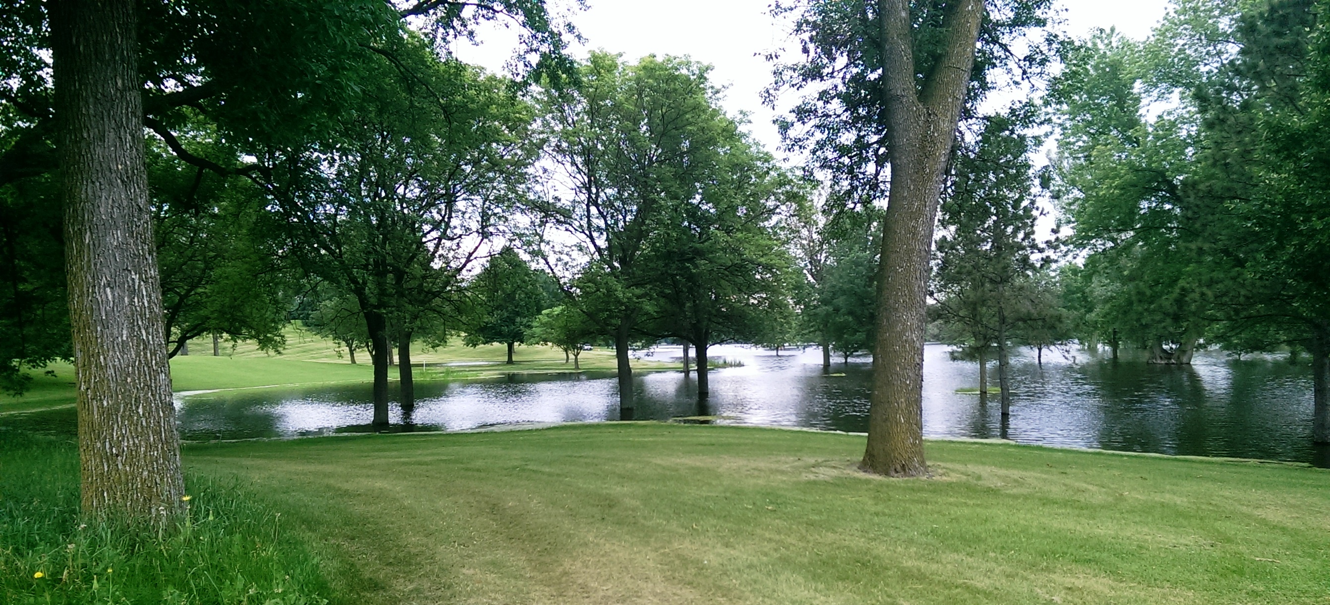
Another shot of the new lake in Meadowbrook Golf Course taken from near Excelsior Boulevard. (David C. Smith)

A different “lake” view, this looking east from Meadowbrook Road through the heart of the golf course. The 14 water hazards the course normally features appear to have merged into one. (David C. Smith)
As of this afternoon, the only Minneapolis public courses that remain closed due to flooding are Meadowbrook and Hiawatha. Only this afternoon, Theodore Wirth began allowing the use of carts again. There is no target date for when the two closed courses will reopen, but it’s likely to be awhile—especially with another 2-4 inches of rain forecast for this weekend.
Not only will cleanup and repair of these courses be expensive, but the revenue they typically generate will be lost to the Park Board for much of the summer.
David C. Smith
© 2014 David C. Smith
Minnehaha Falls and Creek: Flood Stage
Filed under: Minneapolis Lakes, Minneapolis parks, Minnehaha Creek, Minnehaha Falls | Tags: Hiawatha Golf Course, Minnehaha Creek, Minnehaha Falls, Minnehaha Parkway
Comments (10) As we await another early evening thunderstorm, I will post a few historic photos of Minnehaha Creek and Minnehaha Falls taken earlier this afternoon. I call them historic because I’ve never seen the creek this high. One man I encountered on my explorations claimed it was a record water level for the creek. I’ll have to look that up.
The entire length of the creek was flooded, of course, even a few hours after the rain had stopped, but these three photos establish landmarks.

The bridge to nowhere. The creek normally flows under the bridge near the top of the photo. Minnehaha Parkway at Humboldt Avenue South, south of the Lynnhurst Recreation Center. (David C. Smith)
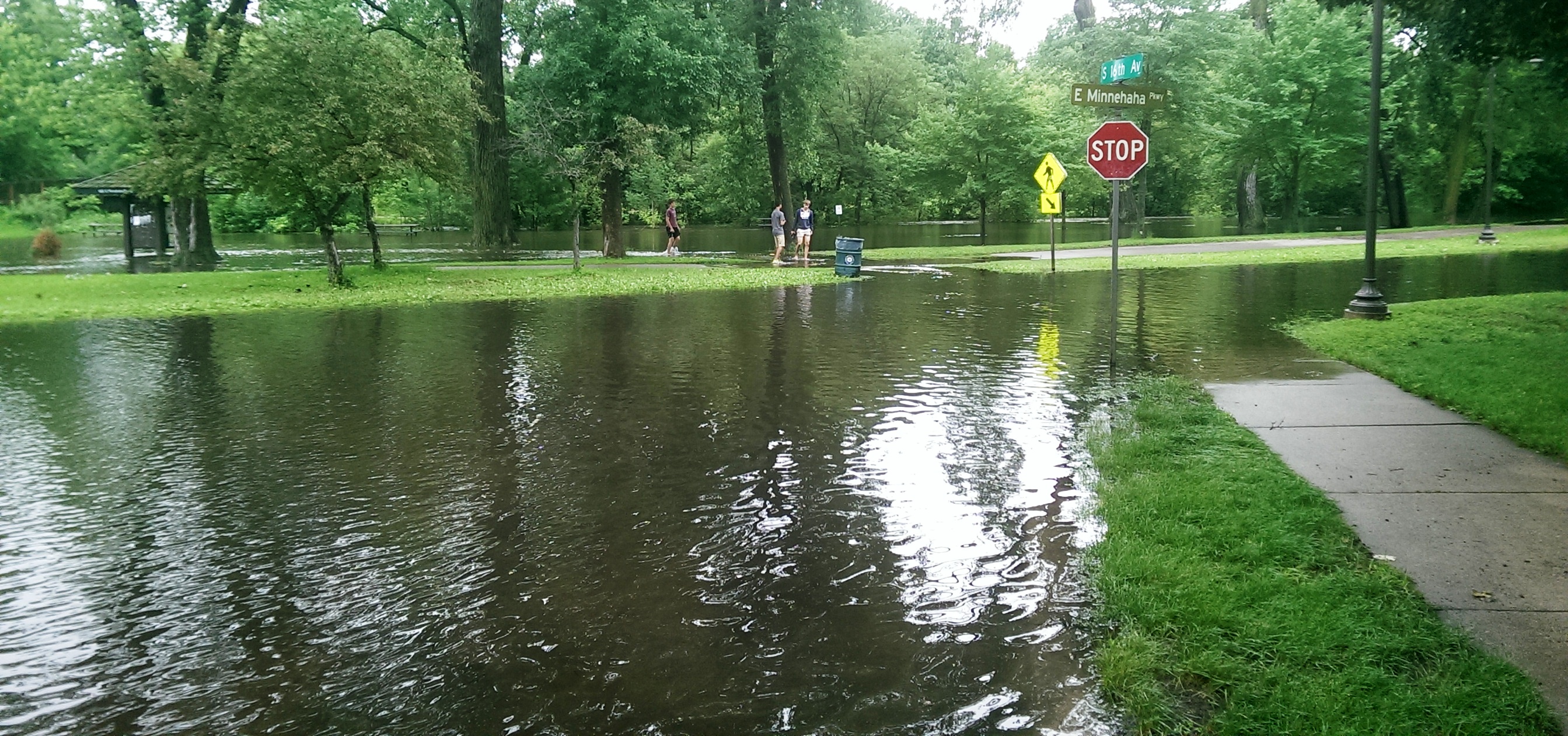
Minnehaha Parkway at 16th Avenue South. (David C. Smith)

Looking west on Minnehaha Parkway at Cedar Avenue South. (David C. Smith)
A man I met near Cedar Avenue claimed that the water reached a similar level after a 1988 thunderstorm, but the water subsided very quickly. Today it didn’t. Minnehaha Parkway was barricaded at many points east of Lake Harriet.

More than a water hazard. Hiawatha Golf Course looking south from E. 43rd Street near Standish. That is not Lake Hiawatha in the foreground. (David C. Smith)

A romantic interlude at the famous rapids of Minnehaha Creek! This is only a few yards upstream from the Hiawatha statue. (David C. Smith)
Some early descriptions of the Falls mentioned the heavy mist generated by the falls. That was true today. There was no rain falling while I was taking the pictures below, but I could feel the water in the air. Not quite as dramatic as Victoria Falls, where the cloud of mist over the falls is visible for miles — it’s called Mosi-o-Tunya, the Smoke that Thunders — but still impressive for this normally modest stream in mid-summer.
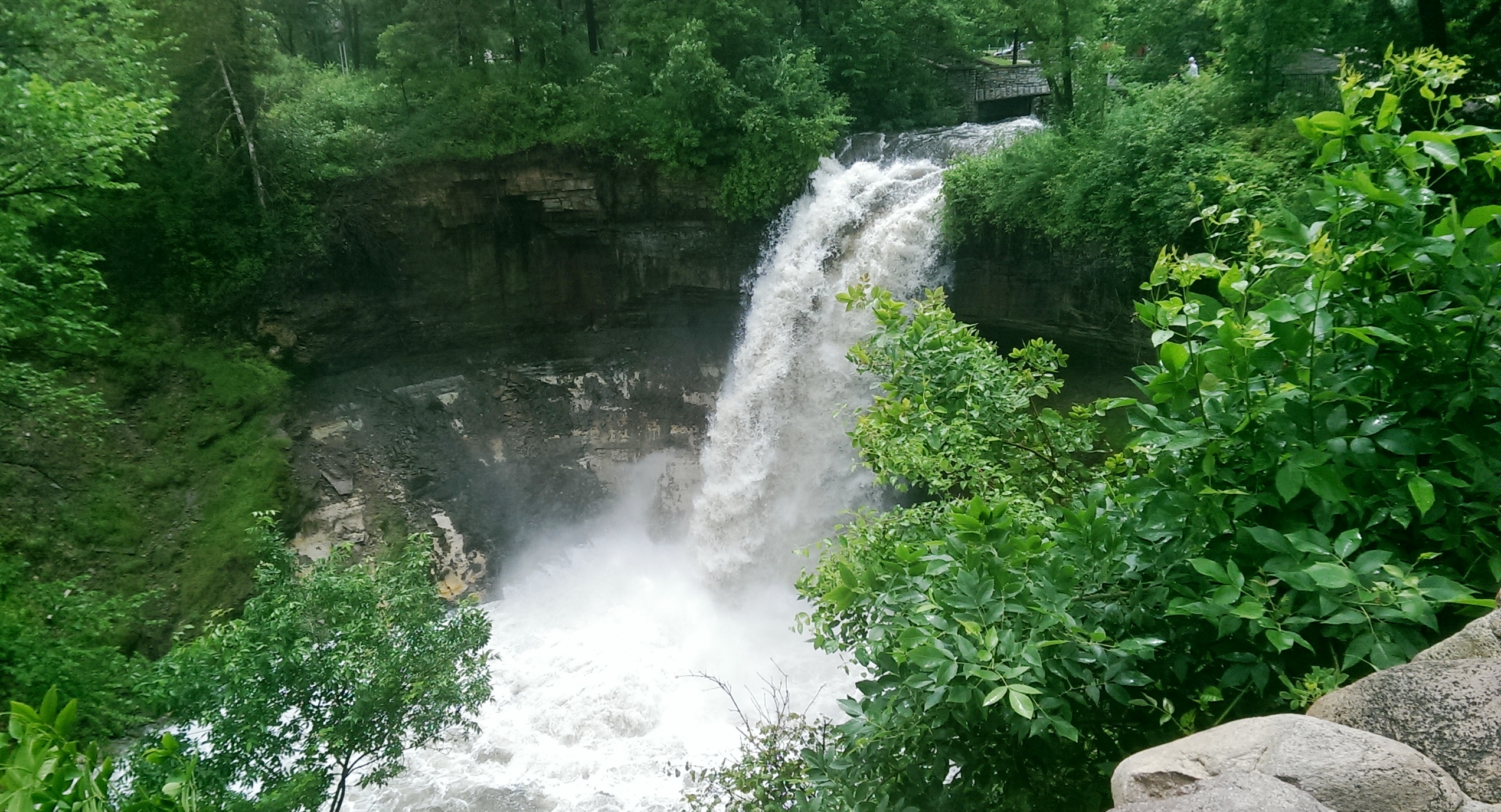
The falls made famous by Henry Wadsworth Longfellow. I recently discovered startling early plans for the park at the falls that I am waiting for permission to reveal. Stay tuned. (David C. Smith)
Unfortunately such high water levels, like the strong winds of recent years, require expensive cleanup efforts from the park board, stretching already tight park maintenance budgets. Kudos and thanks to the park board crews that will put our water-logged parks in beautiful condition yet again.
David C. Smith
© David C. Smith
Does anyone have any pictures to post of Bassett’s Creek in Theodore Wirth Park or downstream to Bryn Mawr before it dives underground? Is Shingle Creek any better?
The Worst Idea Ever #8: Power Boat Canal from Minnetonka to Harriet
Filed under: Minneapolis Lakes, Minneapolis Parks: General | Tags: 1911 Minneapolis Civic Celebration, Lake Harriet, Lake Hiawatha, Lake Minnetonka, Lake Nokomis, Minnehaha Creek, Minnehaha Falls
Comments (1) Ok, it wasn’t really a Minneapolis park project, but it still deserves a laugh: Minnehaha Creek converted into a 30-foot-wide power boat canal from Lake Minnetonka to Lake Harriet!

Lake Harriet could have been more like Lake Minnetonka.
Minneapolis was obsessed in the spring of 1911 with the upcoming Civic Celebration during which the channel between Lake Calhoun and Lake of the Isles would be opened. That was a very good thing. Huzzah, huzzah. But the attention it was drawing to the city also focused a lot of eyes on a very bad thing: Minnehaha Creek was nearly dry — in the spring! — which meant almost no water over Minnehaha Falls. Minneapolis could hardly celebrate the opening of the lake connection at the same time it suffered the ignominy of a dry Minnehaha Falls. The many out-of-town visitors anticipated for the celebration would surely want to see both. And let’s face it, a fifty-foot waterfall written about by a Harvard poet, which attracted visitors from around the world was a bit more impressive to most people than a short canal under a busy road and railroad tracks. The Minneapolis PR machine could call the city the “Venice of North America” all it wanted with its new canal, but visitors’ imaginations were still probably fueled more by the images of the famous poet’s noble heathen, beautiful maiden, and “laughing waters.”
The generally accepted solution to the lack of water over Minnehaha Falls was to divert Minnehaha Creek into Lake Amelia (Nokomis), drain Rice Lake (Hiawatha), dam the outlet of the creek from Amelia to create a reservoir, and release the impounded water as needed — perhaps 8 hours a day — to keep a pleasing flow over the falls. Unfortunately, with all the last-minute dredging and bridge-building for the Isles-Calhoun channel, that couldn’t be done in 1911 between April and July 4, when the Civic Celebration would launch.
Into this superheated environment of waterways and self-promotion stepped Albert Graber, according to the Saturday Evening Tribune, May 28, 1911. With the backing of “members of the board of county commissioners, capitalists, attorneys and real estate dealers”, Graber proposed to dredge Minnehaha Creek into a canal 30-feet wide from Lake Minnetonka to Lake Harriet. This would provide not only a water superhighway from Minnetonka to Minneapolis, and boost real estate prices along the creek, but it would also create a much larger water flow in Minnehaha Creek, solving the embarrassment of no laughing water.
“The plan, say the promoters, would enable residents of summer houses on the big lake to have their launches waiting at the town lake.”
Saturday Evening Tribune, May 28, 1911
Sure, there were problems. Not every plan could be perfect. The plan would require dismantling the dam at Gray’s Bay at the head of Minnehaha Creek, which might lower the level of Lake Minnetonka. But Graber and his backers had thought of that. The Minnesota River watershed in the area of St. Bonifacius and Waconia would be diverted into Lake Minnetonka — no problem! — which also solved another bother: it would reduce flooding on the Minnesota River.
The dam at Gray’s Bay had been operated by Hennepin Country since 1897. Many people then and now consider the dam the cause of low water flow in Minnehaha Creek, but the earliest reference I can find to low water in the creek was in 1820, when the soldiers of Fort Snelling wanted to open a mill on Minnehaha Creek, but were forced to move to St. Anthony Falls due to low water. That was even before two intrepid teenagers from the fort discovered that the creek flowed out of a pretty big lake to the west.
Graber estimated that dredging Minnehaha Creek would cost about $4,000 a mile for the nine miles between the two lakes. He and his backers, which included an officer of the Savings Bank of Minneapolis (who presumably had a summer house on the big lake and could put a launch on the town lake), provided assurances that the money to finance the project could be “readily found.”
The Evening Tribune article concluded with an announcement that meetings of those interested in the project would be held in the near future with an eye to beginning work before the end of the summer. Graber noted that his inspection of the project had been, no surprise, “superficial”, but that he would make a thorough report soon to his backers. I can find no evidence that the idea progressed any further.
The Board of Park Commissioners would have had no role in the plan, except, perhaps, allowing power boats to enter and be anchored on Lake Harriet. (I think they would have said no.) Park board ownership of Minnehaha Creek west of Lake Harriet to Edina wasn’t proposed until 1919 and the deal wasn’t done until 1930.
David C. Smith
© 2013 David C. Smith
1955 Was a Very Dry Year
Filed under: Minneapolis parks | Tags: Bassett's Creek, Brownie Lake, Fairchild Aerial Surveys, Lake Calhoun, Lake of the Isles, Minnehaha Creek, Mississippi River, St.Anthony Falls
Comments (9) It’s not a common sight. I’d never seen it myself until I saw this picture from Fairchild Aerial Surveys taken in 1955. St. Anthony Falls is completely dry.

The concrete apron at St. Anthony Falls is bone dry in 1955. The 3rd Avenue Bridge crosses the photo. Dry land — even a small structure — left (west) of the falls stand where the entrance to the lock is now. (Fairchild Aerial Surveys, Minneapolis Park and Recreation Board)
Water levels were down everywhere at the time. Meteorological charts list 1955 as the 13th driest year on record in Minneapolis, but a look at longer-term data reveal that rainfall had been below normal for most of the previous 40 years. Downstream from St. Anthony Falls, the river was also very low, revealing the former structure of the locks at the Meeker Island Dam.

The old lock structure from the Meeker Island Dam protrudes from the low water in 1955. The old lock and dam between Franklin Avenue and Lake Street were destroyed when the new “high dam” or Ford dam was built near the mouth of Minnehaha Creek downriver. (Fairchild Aerial Surveys, Minneapolis Park and Recreation Board)
That dry spell had a significant impact on park property. Many park board facilities, from beach houses to boat houses and docks, were permanent structures that required proximity to the water’s edge. Parks were also landscaped and mowed to the water line and, since the depression, at least, many lakes had WPA-built shore walls that looked goofy a few feet up on dry land.
Park board annual reports provide time-lapse updates.
1948: Minnehaha Creek dry most of the year, lakes down 1.5 feet.
1949: Chain of Lakes 2 feet below normal, rainfall 2.5 inches below normal, water in Minnehaha for limited time during year
1950: Lake levels at record lows, lake channels dredged 4.5 feet deeper to allow continued use, water in Minnehaha Creek for only brief period in spring
1951: Record snowfall and heavy rains raised lake levels 0.44 feet above normal in April; flooding problems along Minnehaha Creek golf courses required dikes to make courses playable; attendance at Minnehaha Park high all year due to impressive water flow over falls.
1952: Wet early in year, dry late; lake levels stable except those that depend on groundwater runoff, such as Loring Pond and Powderhorn Lake, which were down considerably at end of year
1953: Lake levels fluctuated 1.5 feet from early summer to very dry fall; flow in Minnehaha Creek stopped in November; U.S. Geological Survey began testing water flow in Bassett’s Creek for possible diversion
1954: Again, water level fluctuations; near normal in early summer, low in fall; Minnehaha Creek again dry in November.
1955: Fall Chain of Lakes elevation lowest since 1932, but Lake Harriet near historical normal; Minnehaha dry most of year
1956: Lakes 4 feet below normal, weed control required, boat rentals incurred $10,000 loss
1957: City water — purchased at a discount! — pumped into lakes raised lake levels 1.5 feet; park board began construction of $210,000 pipeline from Bassett’s Creek, which, unlike Minnehaha Creek, had never been completely dry, to Brownie Lake.
1958: Second driest year on record; Minnehaha Creek dry second half of year; pumps activated on pipeline from Bassett’s Creek, raised water level in lakes 4.2 inches by pumping 84,000,000 gallons of water.
1959: Dry weather continued; Park board suggested reduction in water table may be result of development; Park board won a lawsuit against Minikahda Club for pumping water from Lake Calhoun to water golf course. When Minikahda donated lake shore to park board for West Calhoun Parkway in 1908 it retained water rights, but a judge ruled the club couldn’t exercise those rights unless lake level was at a certain height — higher than the lake was at that time — except in emergencies when it could water the greens only. Lakes were treated with sodium arsenite to prevent weed growth in shallower water; low water permitted park crews to clean exposed shorelines of debris.
1960: Lake levels up 4 feet due to pumping and rain fall; channels between lakes opened for first time in two years; hydrologist Adolph Meyer hired to devise a permanent solution to low water levels.

To celebrate the rise in water levels sufficient to make the channels between the lakes navigable after being closed for a couple of years, park superintendent Howard Moore helped launch a canoe in the channel between Lake of the Isles (in background) and Lake Calhoun in 1960. He seems not to mind that one foot is in the drink. (Minneapolis Park and Recreation Board)
That’s more than a decade’s worth of weather reports. The recommendation of hydrologist Adolph Meyer was very creative: collect and recycle water from the air-conditioners in downtown office buildings and stores, and pump it to the lakes. That seemed like a good idea until the people who ran all those air-conditioners downtown thought about it and realized they could recycle all that water themselves through their own air-conditioners and save a lot of money on water bills. End of good idea. Instead the park board extended its Chain of Lakes pumping pipeline from Bassett’s Creek all the way to the Mississippi River. But that’s a story for another time.
If you’ve followed the extensive shoreline construction at Lake of the Isles over the last many years, you know that water levels in city lakes remains an important, and costly, issue—and it probably always will be. It’s the price we pay for our city’s water-based beauty.
David C. Smith
Afterthought: The lowest I ever remember seeing the river was following the collapse of the I-35W bridge. The river was lowered above the Ford Dam to facilitate recovery of wreckage from that tragedy. Following a suggestion from Friends of the Mississippi River, my Dad and I took a few heavy-duty trash bags down to the river bank near the site of the Meeker Island Dam to pick up trash exposed by the lower water levels. Even then the water level wasn’t as low as in the Fairchild photos.
CMPC: Park Property Monuments?
Filed under: Minneapolis parks, Minnehaha Creek | Tags: Minnehaha Creek
Comments (5) This week I was included in an e-mail discussion between MaryLynn Pulscher and Annie Olson at the park board and Daniel Fearn. Daniel had found two interesting metal markers in the ground near Minnehaha Creek.

Marker near Minnehaha Creek (Daniel I. Fearn)
Daniel wondered if CMPC was an acronym for City of Minneapolis Park Commission. My reaction, as well as MaryLynn’s, was that wasn’t likely because the park board until 1969 always marked everything BPC for “Board of Park Commissioners.” The Minneapolis was generally understood.
A web search, however, turned up a document from a Hennepin County Survey that indicates the CMPC stamp may have been used on park board survey monuments. On that document a monument with a similar marker found at 50th and Cedar during the Minneapolis City Survey in 1937 was called a “park board monument”
Do you know the real story of the CMPC markers? Have you seen other markers like this anywhere else in the city? Were they on park boundaries? Or do I have to call the county surveyor’s office to resolve this?
Send photos if you have ’em.
David C. Smith

