Minnehaha Creek Shed Mystery
Here’s your new mystery. (Sorry for filling up your inbox today, but this issue was just raised by a reader as I was posting other things!)
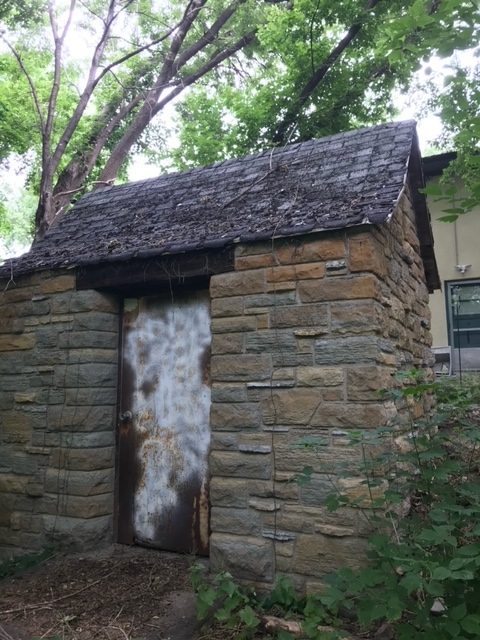
The structure pictured below is on park land just north of Minnehaha Creek and west of Xerxes Avenue. That’s just after the creek enters Minneapolis from Edina. I’ve seen it before and assumed it was on private land. I’m told it’s not.
Was it built as a lift station, pump building, or clandestine meeting place for rogue park commissioners? Any Phryne Fishers or Endeavour Morses out there? Or just humble historians?

If you know anything, please share. We haven’t found mention of the structure in park records.
David Carpentier Smith
P.S. I think we should have a televised Geraldo-Rivera-style reveal of the inside of the structure. I suspect it was haunted or there were some enormous (yeti?) footprints discovered in the vicinity. Any record of unexplained pulsating blue lights in neighborhood lore? Or perhaps tiny notes left beside tree stumps as elves are wont to leave ala mr. little guy. TPT?


I believe we’ve solved our mystery. In The Story of the W.P.A. in the Minneapolis Parks, Parkways and Playgrounds volume for 1940 (dated Jan 1, 1941), page 24, regarding the Minnehaha Parkway:
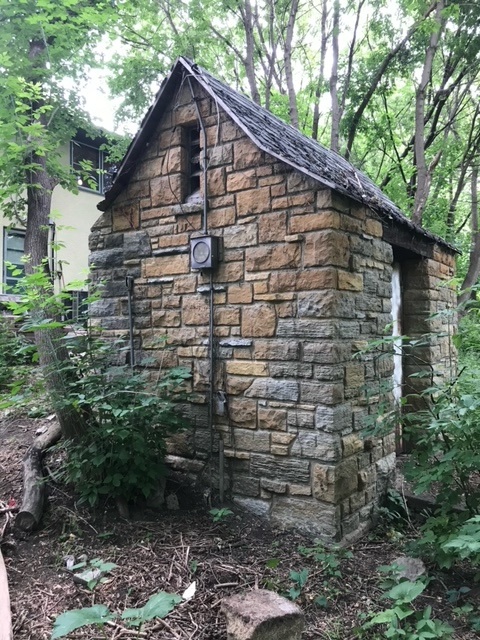
“A small limestone shelter was built north of Minnehaha Creek and west of Xerxes Avenue to house the meter for measuring the amount of sewage entering the city sewer system from the Village of Edina. The village supplied the material for this construction and the work was done by a Park Board W.P.A. crew.” There is an image of the structure on page 25.
These W.P.A. books are really wonderful, and I’m happy to report they are digitized and available online via the Minnesota Digital Library. This volume is here: https://collection.mndigital.org/catalog/p16022coll55:910#?c=&m=&s=&cv=&xywh=-1177%2C0%2C5267%2C3692
Many wonderful images in these volumes!
Thanks David!
Great detective work, Angela. Thanks!
Lots of thoughts, no time to dig: Isn’t there a similar building in Lynnhurst, where the drainage of Lake Harriet crosses 50th by the park? Doesn’t this look like the abandoned toilet buildings that the WPA built in Mhaha Park? Is it mentioned in the WPA parks reports on Digital Reflections? The blueprints for the Mhaha buildings are at the U Architectural Library: are there drawings for this, too? Who has a map with elevations so we can see how the height of land changes: would that make a difference in its use? Is it in the Borchert aerial photos? Fun mystery, but I am so busy I cannot take the time for this just now.
Good ideas, Karen. Congratulations on your new book!
Among the 3 theories you introduced–lift station, pump house, or commissioners’ hideaway–the first 2 are likely. In photo #3, an electric meter and associated conduit are visible, which tells us that there is (or was at one time) some electrically powered device inside. Either a pump or sewer lift would be consistent with that. I tend to discount the pump theory, since it’s so close to the Mpls water works pump station at 40th and France. If it’s a pump facility, it probably has nothing to do with the city water system, and I can’t think of any other entity that would operate a pump house on city property. So that leaves a sewer lift station, which would be electrically powered and would likely be on city property. Since the building has obviously been allowed to fall into disrepair, my guess is that it was decommissioned long ago and simply abandoned or forgotten. In any case, you’ve aroused my curiosity and I’m eager to find out the answer to the mystery.
Thanks, Dan. Great info.
A little Sherlock Holmes work is in order here, lol.
It looks about the size of Thoreau’s cabin on Walden Pond. Could I live there? I promise to keep a detailed journal. Maybe we could get someone at MPRB to give us a photo of what’s inside. Is that possible?
Interesting-I haven’t seen that or the type of brick used before, but the condition of the roof bring thoughts as to the roofing on the Harriet Bandshell. It seems that the Stevens house is missing some love as well. We drove the lakes and parkway recently on an early Sunday and decided that it reminds of similar drives 50+ years ago as we were bounced around with the rough pavement condition-maybe a speed control mechanism? It works. So, no change there or the underside of the Nic bridge as we hoped a concrete chunk wouldn’t drop off on us. Nice to see your posting.
Nice to hear from you, Dan. I like the look of that stone. As for parkways, I like to think that they suffer some wear because they are so well-loved and used! I believe repairs to the bandshell roof are in the works.
Thanks for your community sourcing on this mystery, David! Looking through the MPRB Archives, I haven’t found information yet but I think there is some hope for a clue, tbd. Though I am curious to hear what others know! Thanks again!
Please let us know what you find, Angela. (An introduction: Angela is the MPRB’s archivist. I’m delighted that park commissioners have maintained the position even though it is only part-time. It’s hard to know where we are if we don’t know where we were.