Archive for the ‘Minnehaha Parkway’ Tag
Minnehaha Creek Shed Mystery
Filed under: Minneapolis Parks: General | Tags: Minneapolis parks, Minnehaha Creek, Minnehaha Parkway
 Comments (12)
 Here’s your new mystery. (Sorry for filling up your inbox today, but this issue was just raised by a reader as I was posting other things!)
The structure pictured below is on park land just north of Minnehaha Creek and west of Xerxes Avenue. That’s just after the creek enters Minneapolis from Edina. I’ve seen it before and assumed it was on private land. I’m told it’s not.
Was it built as a lift station, pump building, or clandestine meeting place for rogue park commissioners? Any Phryne Fishers or Endeavour Morses out there? Or just humble historians?
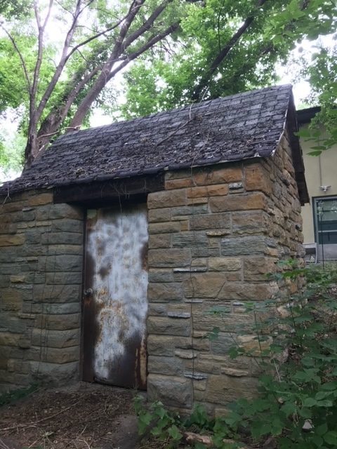

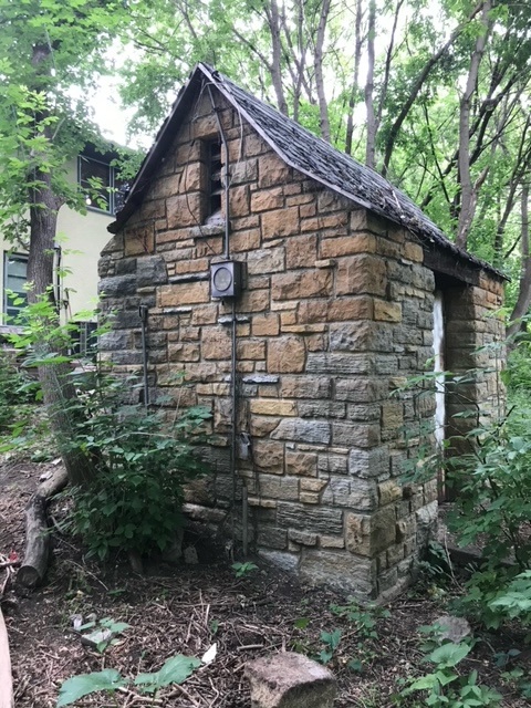
If you know anything, please share. We haven’t found mention of the structure in park records.
David Carpentier Smith
P.S. I think we should have a televised Geraldo-Rivera-style reveal of the inside of the structure. I suspect it was haunted or there were some enormous (yeti?) footprints discovered in the vicinity. Any record of unexplained pulsating blue lights in neighborhood lore? Or perhaps tiny notes left beside tree stumps as elves are wont to leave ala mr. little guy. TPT?
Closing Parkways: Not a New Idea, or a Good One
Filed under: Grand Rounds, Minneapolis Park Board, Minneapolis parks | Tags: Garret Eckbo, Grand Rounds, Minnehaha Parkway, Robert Ruhe
Comments (5) The Minneapolis Park Board considered chopping up the Grand Rounds once before. That proposal was rejected, as I hope this one will be.
On May 30, the park board published a draft of its “preferred concept” for the Minnehaha Parkway Regional Trail from where Minnehaha Creek enters Minneapolis from Edina, east to Hiawatha Avenue near Minnehaha Park. I would encourage everyone to review the draft concept, especially page 7 of the linked document, which addresses “Parkway Vehicluar Circulation.” I believe that is where the plan fails, because it proposes to place roadblocks at some intersections that will force cars to leave the parkway, which creates in essence more “missing links” in the Grand Rounds. It will essentially end the practice of driving Minnehaha Parkway for pleasure. Continue reading
Monument Men: Minneapolis Park Board Property
Filed under: Minneapolis parks | Tags: Minneapolis Park and Recreation Board, Minnehaha Parkway, Northeast Athletic Field Park
Comments (1) I received a note today from Craig E. Johnson that might help solve a mystery from 2012 when I posted another note about an unusual marker found near Minnehaha Parkway.
“I’m a land surveyor and work for Clark Engineering in Golden Valley. We recently did a survey of the Northeast Athletic Field Park in Minneapolis where we found a monument similar to the ones you were asking about in a blog in 2012. I thought you might be interested in a photo, this monument was found on a park boundary.”
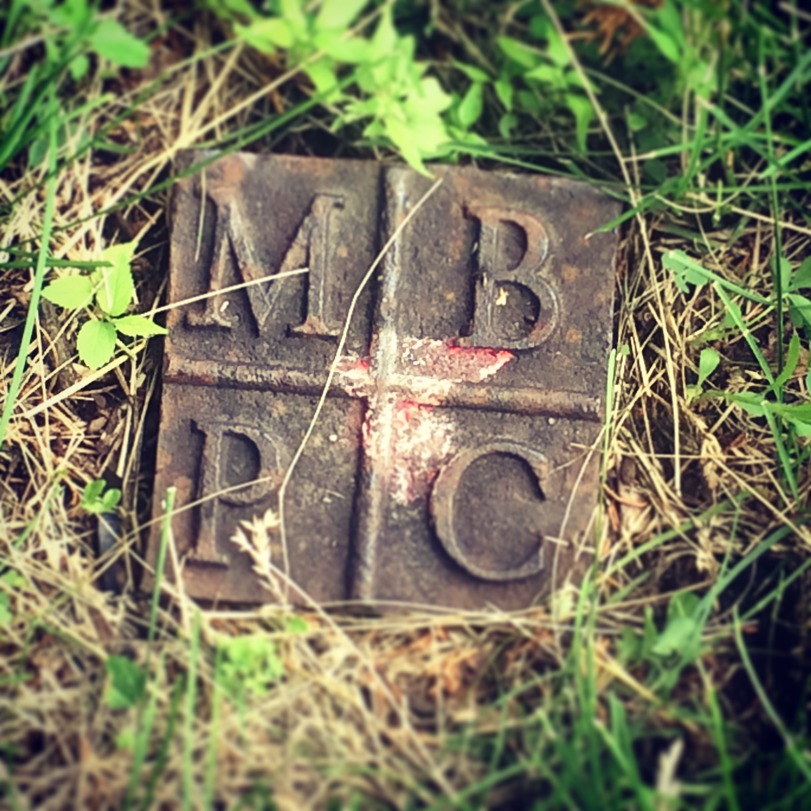
The property marker Craig Johnson found in Northeast Athletic Field Park is, he says, “almost certainly” a park boundary marker.
The letters MBPC on the marker probably stand for “Minneapolis Board of Park Commissioners”, the official name of the park board until 1969, when it became Minneapolis Park and Recreation Board or MPRB.
While the letters and type face on the marker found near Minnehaha Parkway are different—CMPC—the design is the same, which suggests they may be related. The Minnehaha Parkway marker appears much older, which would make sense as that property was acquired by the park board, therefore surveyed, about sixty years before Northeast Park. The park board acquired most of Northeast Park in 1941, at no cost, from the state of Minnesota as tax-forfeited property. Most improvements were delayed, however, until well after World War II.
To catch up with the exciting changes taking place now at Northeast ,visit the park board’s website.
Thanks for the info and photo, Craig.
David C. Smith
© 2015 David C. Smith
Minnehaha Falls and Creek: Flood Stage
Filed under: Minneapolis Lakes, Minneapolis parks, Minnehaha Creek, Minnehaha Falls | Tags: Hiawatha Golf Course, Minnehaha Creek, Minnehaha Falls, Minnehaha Parkway
Comments (10) As we await another early evening thunderstorm, I will post a few historic photos of Minnehaha Creek and Minnehaha Falls taken earlier this afternoon. I call them historic because I’ve never seen the creek this high. One man I encountered on my explorations claimed it was a record water level for the creek. I’ll have to look that up.
The entire length of the creek was flooded, of course, even a few hours after the rain had stopped, but these three photos establish landmarks.

The bridge to nowhere. The creek normally flows under the bridge near the top of the photo. Minnehaha Parkway at Humboldt Avenue South, south of the Lynnhurst Recreation Center. (David C. Smith)
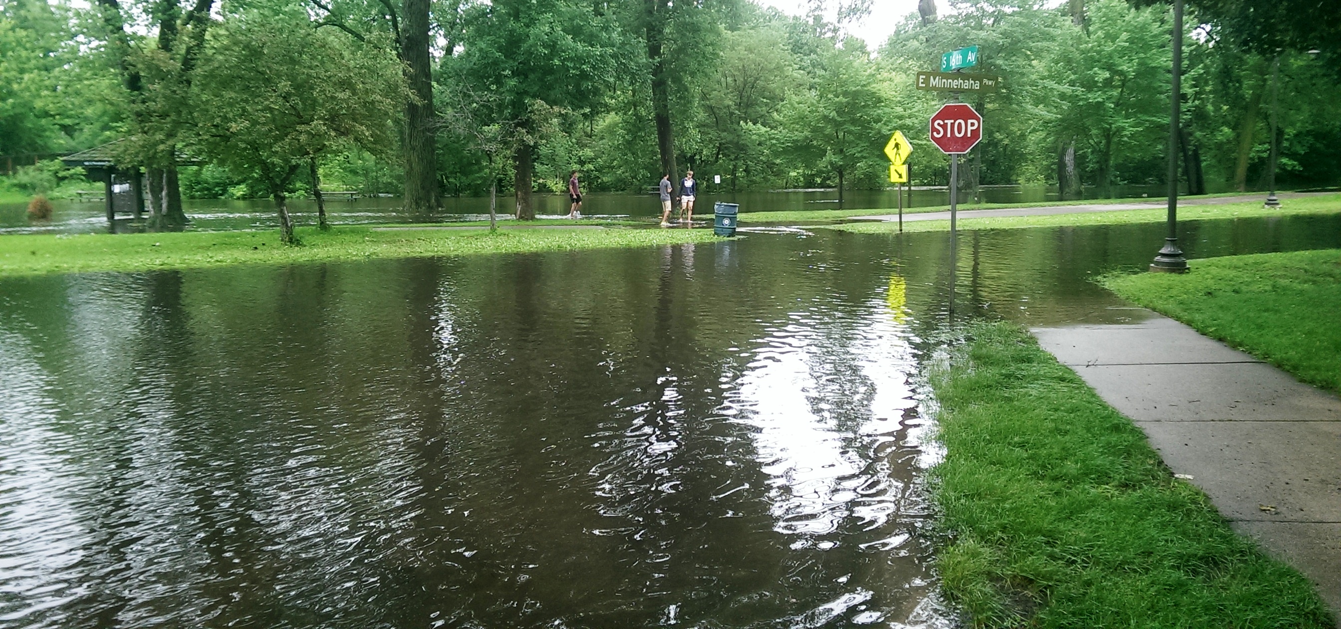
Minnehaha Parkway at 16th Avenue South. (David C. Smith)

Looking west on Minnehaha Parkway at Cedar Avenue South. (David C. Smith)
A man I met near Cedar Avenue claimed that the water reached a similar level after a 1988 thunderstorm, but the water subsided very quickly. Today it didn’t. Minnehaha Parkway was barricaded at many points east of Lake Harriet.

More than a water hazard. Hiawatha Golf Course looking south from E. 43rd Street near Standish. That is not Lake Hiawatha in the foreground. (David C. Smith)

A romantic interlude at the famous rapids of Minnehaha Creek! This is only a few yards upstream from the Hiawatha statue. (David C. Smith)
Some early descriptions of the Falls mentioned the heavy mist generated by the falls. That was true today. There was no rain falling while I was taking the pictures below, but I could feel the water in the air. Not quite as dramatic as Victoria Falls, where the cloud of mist over the falls is visible for miles — it’s called Mosi-o-Tunya, the Smoke that Thunders — but still impressive for this normally modest stream in mid-summer.
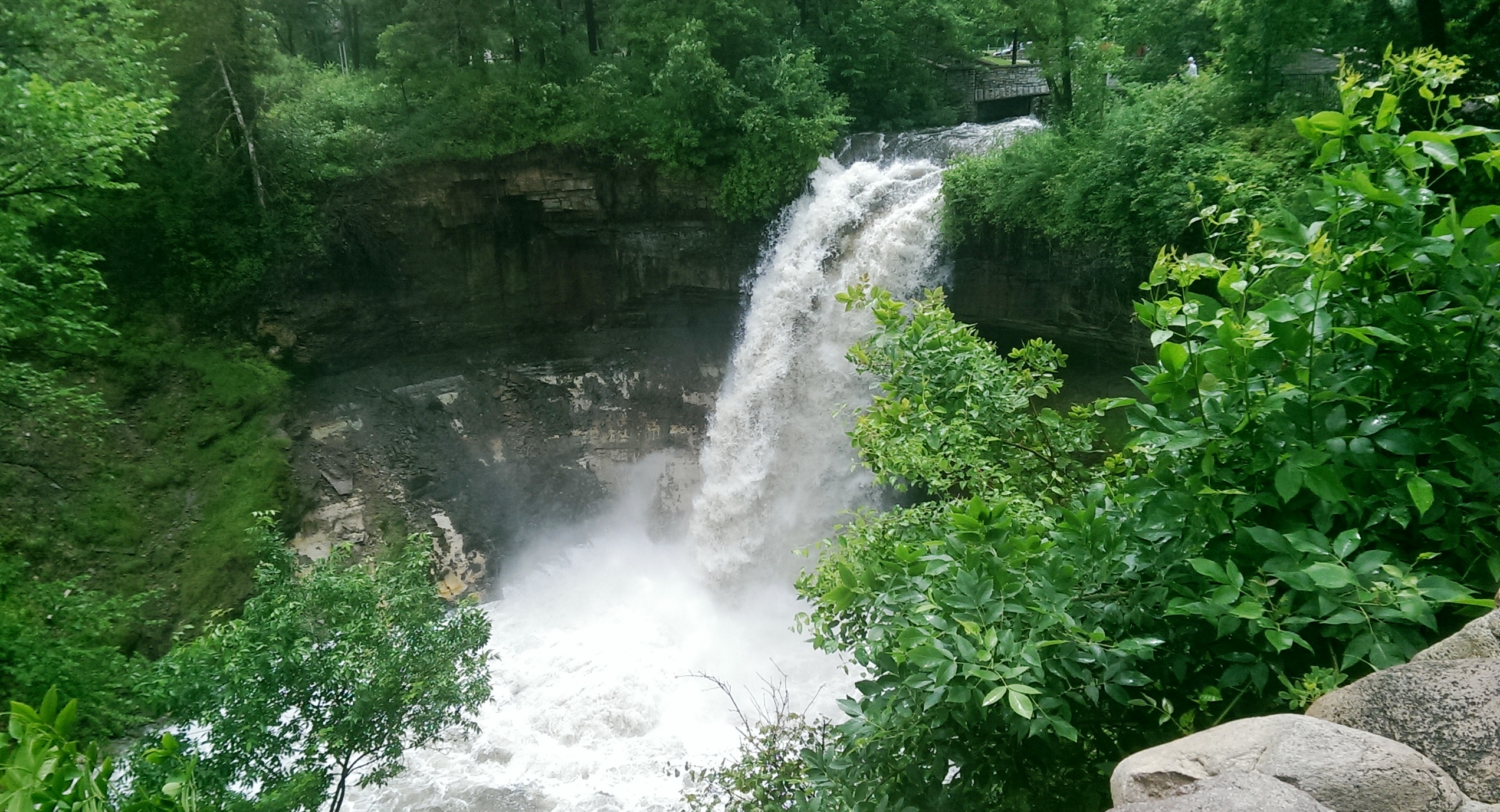
The falls made famous by Henry Wadsworth Longfellow. I recently discovered startling early plans for the park at the falls that I am waiting for permission to reveal. Stay tuned. (David C. Smith)
Unfortunately such high water levels, like the strong winds of recent years, require expensive cleanup efforts from the park board, stretching already tight park maintenance budgets. Kudos and thanks to the park board crews that will put our water-logged parks in beautiful condition yet again.
David C. Smith
© David C. Smith
Does anyone have any pictures to post of Bassett’s Creek in Theodore Wirth Park or downstream to Bryn Mawr before it dives underground? Is Shingle Creek any better?

