Archive for the ‘Minneapolis Lakes’ Category
G’day Maka Ska, G’bye Calhoun?
Filed under: Minneapolis Lakes, Minneapolis Park Board, Minneapolis Parks: General | Tags: Bde Maka Ska, Lake Calhoun
 Comments (14)
 Efforts to eradicate the name Lake Calhoun and replace it with Bde Maka Ska have generated a great deal of discussion and passion on many sides. The usage of the recommended new name and its meaning and pronunciation have been badly muddled, however, which confuses the issues unnecessarily.
Let me, a non-Dakota speaker, try to clarify. Bde Maka Ska is one of the Dakota names for the lake that was named Lake Calhoun by white surveyors or soldiers sometime before 1820. We have been told often that the term translates as White Earth Lake. So far, so good. But let’s break it down further.
Translation
Bde: lake
Maka: earth
Ska: whitePronunciation
Bde: The “e”, as in Spanish, is more like “ay” as in day. Hear Crocodile Dundee saying “G’day, mate.” Say b’day like an Australian caricature says “g’day” — rather than b-day which suggests a pronunciation more like a fixture in a French bathroom. G’day. B’day. Closer to one syllable than two.
Makaska: I’ve cheated and put the two words together, which to my ear is how Dakota speakers pronounce them. All a’s are pronounced as in “Ma” for mother. Accent the middle syllable, as if you were saying “my Costco.” MaCostco. Makaska.
This is the easy part and should not have any bearing on the merits of changing the name. It’s not hard to say, so let’s not use that excuse. How do you know how to pronounce “Isles” in “Lake of the Isles” with two of five letters silent? You learned — and thought nothing of it. Not difficult.
Usage
This is a little trickier. I don’t know Dakota patterns of usage, but to my view the Minneapolis park board’s master plan entitled Calhoun/Bde Maka Ska-Harriet, which recommended the name change, is confusing. If we are dropping “lake” from Lake Calhoun and Lake Harriet, in this context shouldn’t we also drop “bde” from Bde Maka Ska. Otherwise it would be Lake Lake White Earth.
In other words, Bde Maka Ska replaces Lake Calhoun, not just Calhoun. Maybe Dakota grammarians would box your ears if you said the equivalent of, “I’m going to bike around Maka Ska this afternoon.” Maybe in Dakota “lake” or “bde” must always be part of a lake name. But if the “bde” doesn’t have to bde there, couldn’t the park board have approved renaming the lake “Maka Ska”? I ask in part because I haven’t heard any objection to the word “lake” itself, although Tony Lake, Lake Street, and Veronica Lake all have had detractors. (I’ve never seen her right eye!)
It matters because any use of Calhoun alone then is unaffected, which is a bit exasperating, because that’s the objectionable part. So on the parkway signs that say East (or West) Calhoun Parkway it was incorrect to add Bde Maka Ska, as was done last year. Only signs that say “Lake Calhoun” should have been changed. Even the vandals of signs at Lake Calhoun last year didn’t know what they were doing when they replaced only Calhoun, but not Lake, with Bde Maka Ska. Pretty ignorant activism.
I raise this issue primarily for clarification. We know some lakes around the world by their indigenous names, Loch Ness comes to mind, and others have retained names given by non-English speakers, such as Lac qui Parle in western Minnesota (not just a lake but a county), a French translation of the Dakota words “lake that speaks”. (Was “bde” part of that Dakota name?)
Something to Consider
So… how should we treat Bde Maka Ska? Wouldn’t it be easier to discuss the merits of a name change if we said we wanted to change the name from Lake Calhoun to Lake Maka Ska? Dakota and Ojibwe names for lakes and places abound in Minnesota and no one seems to have a problem with that. Yet I’ve never seen any other lake named Bde Anything. There are many a “mni” — Dakota for “water” — anglicized to Minnetonka, Minnesota, Minnehaha, but not a “bde” that I know of.
I suspect that some people opposed to renaming the lake get hung up on “bde” for “lake”. It’s a diversion from the real issues, which are, “Calhoun or not?” And, “If not, what?” Lake Maka Ska might eventually be adopted by those who don’t speak Dakota. Bde Maka Ska will take decades longer — if the bde isn’t dropped quickly anyway.
Where Does the Name Come From?
Knowing a bit of the history of Lake Calhoun since 1820, I’m also curious how the lake got the name “White Earth”. We know that parts of the shoreline, especially on the south and west, were quite marshy by the mid- to late-1800s and had to be filled eventually to hold parkways. But we also know from dredging reports that the beach on the north side at the site of the bath house built in 1912 was created or greatly augmented by considerable dredging from sand found on the lake bottom.

Lake Calhoun’s northwest shore and Bath House in late 1910s, before a parkway existed on the west side of the lake, although there is a light-colored trail or path. The north beach was mostly man-made. Photo likely taken from near the Minikahda Club. (Minneapolis Park and Recreation Board)
To my knowledge the dredging at Lake of the Isles and Cedar Lake produced little sand from those lake bottoms. Lake Harriet has never been dredged. It’s not obvious from any accounts I’ve seen of why “maka ska” or “white earth” was used to distinguish this lake from neighboring lakes in Cloud Man’s time or earlier.
Maybe a geologist could enlighten me. Were there relatively white deposits of sand in the vicinity at some point? What is the geological explanation? (For those of us who still believe in science anyway.) Were the shores of Lake Calhoun once sandy — before beaches, parkways and retaining walls?
If anyone can enlighten us about the Dakota language or can explain the park board’s garbled use of Bde Maka Ska, sometimes as a substitute for Lake Calhoun and others for Calhoun only, or can tell us about “white earth”, please do. I won’t post comments on whether we should keep or erase the Calhoun name; many other venues provide space for those arguments.
David C. Smith
More Lake Nokomis Bath House
Filed under: Minneapolis Lakes, Minneapolis parks | Tags: Lake Nokomis Bath House
Comments (4) In an enjoyable article on Lake Nokomis in MinnPost, Andy Sturdevant provided a link to a couple photos I posted last month of the Nokomis Bath house, so I thought I’d return the favor. I’ve been intending to post this new photo of the bath house I found on a 1920s postcard, so Andy’s article provides a good excuse. I had not seen this photo until a few weeks ago.

Lake Nokomis Bath House in the 1920s. Photographer unknown.
Anyone who knows old cars might be able to date this photo more precisely than I have. Anybody know their early autos? Let us know a likely date range. Based on the age of the trees I would guess it must be very early 1920s.
You can make out the Cedar Avenue bridge in the background. Theodore Wirth wanted to reroute Cedar Avenue around the southwest lagoon shortly after the area was annexed by Minneapolis from Richfield in 1926, but there was too much opposition from property owners in that direction, so we still have that unusual bridge on a county road over a lake.
David C. Smith
Charles Loring: “We must control the lake.”
Filed under: Loring Park, Minneapolis Lakes, Minneapolis parks | Tags: Charles M. Loring, Florence Barton Loring, Lake Calhoun, Lake Harriet, Lake of the Isles, Minneapolis parks, Minnehaha Falls
Comments (3) If you have read my history of the Minneapolis park system, City of Parks, you may recall that Charles Loring’s efforts to acquire land around lakes Harriet, Isles and Calhoun remain a subject of speculation. No one has ever found a clear strategy or well-documented plan by Loring, the first president of the Minneapolis Board of Park Commissioners, to acquire the lakes, even though he spent the better part of several years in getting those complicated real estate deals done. I focused mostly on Loring’s desire to create a parkway from Loring Park, then still called Central Park, around the lakes to Lake Harriet, which had been acquired already for the fledgling park board largely by gift. Even the generous gift of land around Lake Harriet by Henry Beard, James Merritt, Charles Reeve and, ultimately, William King, was prompted by the desire to have a parkway around the lake, which accounts for the limits of the original gift: a strip of land only 125 feet wide around Lake Harriet—just enough for a walking path, a carriage way and a few trees or flowers to dress it up.
A new discovery suggests, however, that Loring had much more in mind than parkways. As part of the ongoing project to inventory the park board’s historical records with the goal of making them more accessible to researchers, I recently found a letter written by Loring in 1886 that sheds more light on his thinking about the lakes.
The letter, dated June 14, 1886 and addressed to park board secretary Rufus Baldwin, discusses Loring’s views on what needs to be done to acquire land at Lake of the Isles. Loring notes that Alfred Dean, who owned much of the land that had to be crossed by a parkway at Lake of the Isles, had already told Loring he could do whatever he wished. Loring then wrote,
“My opinion is that we do not want the land on the outside, but do want it next the lake. As the plat now is, the boulevard goes around the little marsh thus.”
Loring then includes a small drawing.

Charles Loring’s letter to Rufus Baldwin, June 14, 1886
He is very explicit, writing on the road next to the lake “This is what we want” and concluding bluntly, “We must control the lake.”
This evidence that Loring was thinking far beyond parkways is reinforced by the concluding page of his letter when he addresses a new topic: boats on Lake Harriet. He notes that a steamer has been placed on the lake and he has asked the owner to remove it, but adds that after talking with “Judge Fish”—park board attorney Daniel Fish—Loring doesn’t want legal questions raised yet about “rights on the water”. Clearly, Loring is thinking about park board control not just of boulevards around the lake, but activity on the lake as well. His earlier comment, “We must control the lake”, takes on even greater significance.
We may owe even more to Charles Loring and his vision than we previously knew.
While on the subject of Loring I want to mention a note I received a while ago from, William Scott, the great-great-nephew of Charles Loring’s second wife Florence Barton Loring. You can read more about his family’s relationship with the Bartons and Lorings in the “Comments” section here.
This is the carte de visite of Florence Barton that he refers to. Thanks to William Scott for sharing the photos below.

Florence Barton, date unknown. (Beal Art Gallery, Harold W. Scott Collection, courtesy William Scott)
This must have been taken long before she married Charles Loring at age 45 in 1895. Read much more about Florence Barton Loring here.
William Scott also sent a photograph of family and friends at Minnehaha Falls in about 1910. Love those hats! The new bridge with the boulder face over a concrete structure was brand new in 1910. Appears to be a dry year.

David C. Smith
© 2016 David C. Smith
Memories of Lake Harriet
Filed under: Minneapolis Lakes, Minneapolis Park Memory, Minneapolis parks | Tags: Lake Harriet, Lake Harriet Pavilion, Lyndale Farmstead, Lyndale Park
Comments (8) The following letter, dated July 9, 2014, was addressed to the Minneapolis Park and Recreation Board:
On July 4, 2014 my daughter sent me pictures of two of my great grandsons enjoying the holiday at Lake Harriet. I recently celebrated my 95th birthday and those pictures brought a deluge of memories to me. My two sisters and I grew up on Bryant Ave. So. in the 4100 block, just a few blocks from Lake Harriet, Lyndale Park and Lyndale Farmstead.
One of my early memories is from the early 1920s when dinners were served in the old pavilion where the modern band shell now stands. It was July 8, 1925 and my father decided it looked too stormy to go to dinner at the pavilion. That evening a tornado struck the area and the pavilion was devastated. Several lives were lost when the pavilion collapsed. I was 6 years old but I remember walking around the lake several days later and seeing the damage to the trees and the lake shore.
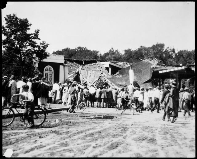
A storm destroyed the Lake Harriet Pavilion in 1925, resulting in two deaths. (Minnesota Historical Society)
There is no continuity to these memories as I write them down. Walking to the lake in the early spring and the scent and beauty of the lilacs along King’s Highway. The rose garden in summer which still looked the same in the pictures with the boys. The walk through the woods on the bridle path with the sounds and sights of the birds in the bird sanctuary.
The many picnics we had as a family by the lake and the band concerts that climaxed the day. The salt-water taffy, popcorn and balloons, the walk home along the lake shore through the park where it seemed there were always fire flies lighting our way. Often we left before the end of the concert and if the wind was right, we could hear the band playing the Star Spangled Banner and we knew the concert was over. All summer we swam at the 48th Street beach
I also recall when the launch on Lake Harriet was part of the Minneapolis Street Car Company and made stops at the docks at Penn. Ave., Morgan Ave., 48th Street and 43rd Street. We enjoyed coming from downtown on the Oak Harriet line and transferring to the launch at the pavilion for a cool ride home on a hot summer day, and a short walk home from the 43rd Street dock.
In the winter our sleds were on the easy slopes in the park adjacent to the rose garden. When we grew older, we advanced to Lyndale Farmstead and dared to slide on King’s Hill. At that park we skated all winter, played tennis in the summer and enjoyed the chrysanthemum gardens in the fall.
Another memory of Lyndale Park was the annual pageant with acts from every park in the city. The pageant was magic in the eyes of children.
Over the years I have made many trips back to the Bryant Ave. home. My mother and I would walk around the lake and my children and grandchildren would enjoy the same things I did as a child.
Theodore Wirth’s dream of a park within 6 blocks of every home in Minneapolis has been perpetuated and I, at 95, can from my home in Alaska live these memories.
Margaret J. Hall, Kodiak, Alaska
Note: I was given this letter recently at a meeting at the park board, so I wrote to Ms. Hall to ask her permission to reprint it here. Because the letter was nearly a year old and Ms. Hall was 95 when she wrote it, I wasn’t sure if I would get a response. I was delighted to receive a letter from her this morning granting permission to publish her letter.
She added:
When I got your letter I went to my computer and looked at your blog. (Yes, I do have a computer, but I still prefer letter writing.) More memories immediately came. My letter only included the parks within walking distance of our home and didn’t include the street car rides to Minnehaha Park and all its magic, Sunday rides to Loring Park, and to Powderhorn Park for the fireworks.
As I approach my 96th birthday on June 15th, I think of an ideal celebration: a picnic at Lake Harriet, a ride on the launch, and a band concert in the evening.
Thanks for sharing your memories with us, Margaret. So much has changed in the last century, yet some things endure.
David C. Smith
1911 Minneapolis Civic Celebration: Junk Mail
Filed under: Minneapolis Lakes, Minneapolis Park Board, Minneapolis parks | Tags: 1911 Minneapolis Civic Celebration, Cedar Lake, Chain of Lakes, Kenilworth Lagoon, Lake Calhoun, Lake of the Isles, Southwest LRT
Leave a comment I have neglected these pages in recent months, yet I have so many good park stories to tell, some of them from readers. I will get to them soon I hope. In the last eight months I have discovered more fascinating information about Minneapolis parks and the people who created them than at any time since my initial research for City of Parks. But until I can get to those stories, I wanted to show you one of the more interesting bits of history I’ve encountered recently. Garish, but oddly charming.
The images below are of a promotional envelope used by a Minneapolis merchant in advance of the July 1911 Civic Celebration that was conceived primarily to celebrate the digging of the channel that connected Lake Calhoun with Lake of the Isles — as is noted at the bottom of the envelope. I found these images on an Ebay auction site and use them with permission of the seller of the envelope who sells mostly postal history under the name of “gregfree”. This envelope is for sale at an opening bid of $150 — more than I can pay. I appreciate gregfree’s willingness to let me share the image with you. Maybe you should buy it. If you do, thank him for me.

A promotional envelope used by a Minneapolis merchant. One of the objectives of the Civic Celebration was to give businesses an opportunity to contact, perhaps entertain and certainly solicit business from their clients throughout the region.
I love the background in green, a photo of the Stone Arch Bridge and Mill District, laid over a map of the city that shows the Chain of Lakes and Minnehaha Creek meeting the Mississippi River in the lower right corner.

The back of the envelope is an advertisement for Minneapolis, and from my perspective the lede is not buried — “Public Park System Unequalled.” That puts the emphasis exactly where it should be!
It’s nice to know that Minneapolis also had the lowest death rate in the United States. How that was measured, I’m not sure.
The coincidence of me finding this image now has a bit of Ouija-Board spookiness to it, because the lake connections have been on my mind — and in the news — a good bit lately. The channel that was celebrated 103 years ago between Isles and Calhoun has been in the news because the developer of a residential building at Knox Avenue and Lake Street has been pumping millions of gallons of water from a flooded underground parking garage into that channel, which has prevented it from freezing and caused considerable increase in phosphorous levels in the lake. More phosphorous means more algae. The Park Board and the City have sued to stop the pumping. Good! Such negligence on the part of a developer is astonishing. Hmmm, what do you think might happen if you put a parking garage below the water table between two lakes? I’m no engineer, but I think I’d be a tad suspicious of anyone who told me, “Hey, no problem.” The next time you hear people complaining about too much government regulation, ask them if it’s cases like this that they have in mind? I hope the Park Board uses every weapon at their disposal in this case to protect our lakes.
The other lake connection issue is not so clear-cut, but may be more important. That is the issue of tunneling under or bridging over the Kenilworth Lagoon that connects Lake of the Isles and Cedar Lake in order to build the Southwest LRT.
The history of other interests, public and private, wanting to take a little park land here or there for this or that good idea is long and sordid. For decades the park board has had to fight those who wanted just an acre or a little easement across park property. If the Park Board had acquiesced, all we’d have left of a magnificent park system would be a couple triangle parks. The reasons for taking park land have often been legitimate. For instance, I’m strongly in favor of better mass transit in Minneapolis and the entire Twin Cities metro area, but only if it doesn’t harm parks — or even the notion of parks. Is a tunnel or a bridge over Kenilworth channel better for the LRT? That question and a hornets nest of others, isn’t the right place to start. The only place to start in my very prejudiced opinion is with “Will it harm park property?” If the Park Board determines that the answer to that question is “Yes,” it is obliged to oppose those plans with all its might — regardless of how small the “harm.” Because in historical terms, “harm” seems more than precedent, it is invitation.
I have more to write about the issue. Did you know that the Park Board once went to the United States Supreme Court to prevent the State of Minnesota from taking Minneapolis parkland? True story. Til then quite an interesting envelope. Thanks again gregfree.
David C. Smith
© 2014 David C. Smith
Minnehaha Falls and Creek: Flood Stage
Filed under: Minneapolis Lakes, Minneapolis parks, Minnehaha Creek, Minnehaha Falls | Tags: Hiawatha Golf Course, Minnehaha Creek, Minnehaha Falls, Minnehaha Parkway
Comments (10) As we await another early evening thunderstorm, I will post a few historic photos of Minnehaha Creek and Minnehaha Falls taken earlier this afternoon. I call them historic because I’ve never seen the creek this high. One man I encountered on my explorations claimed it was a record water level for the creek. I’ll have to look that up.
The entire length of the creek was flooded, of course, even a few hours after the rain had stopped, but these three photos establish landmarks.

The bridge to nowhere. The creek normally flows under the bridge near the top of the photo. Minnehaha Parkway at Humboldt Avenue South, south of the Lynnhurst Recreation Center. (David C. Smith)
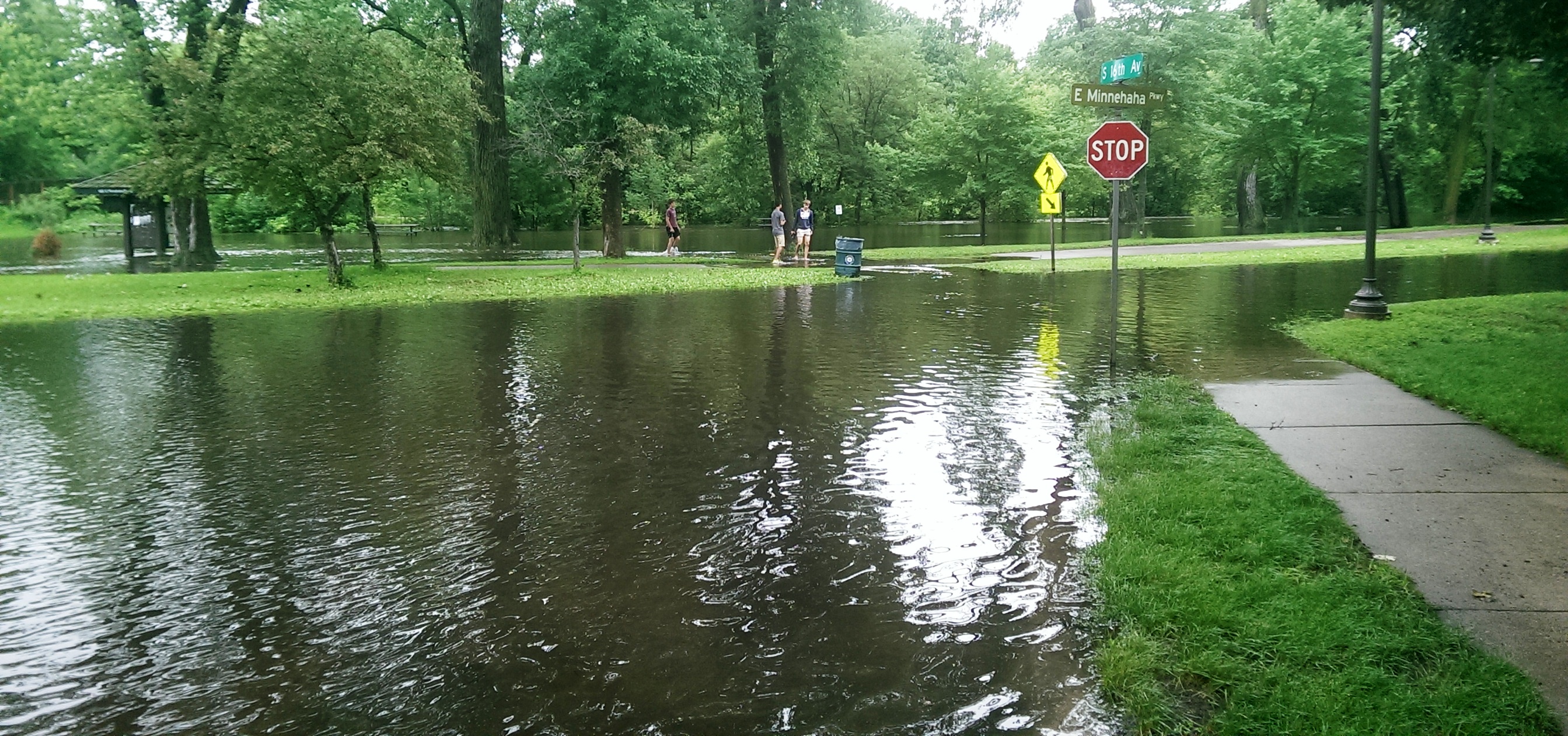
Minnehaha Parkway at 16th Avenue South. (David C. Smith)

Looking west on Minnehaha Parkway at Cedar Avenue South. (David C. Smith)
A man I met near Cedar Avenue claimed that the water reached a similar level after a 1988 thunderstorm, but the water subsided very quickly. Today it didn’t. Minnehaha Parkway was barricaded at many points east of Lake Harriet.

More than a water hazard. Hiawatha Golf Course looking south from E. 43rd Street near Standish. That is not Lake Hiawatha in the foreground. (David C. Smith)

A romantic interlude at the famous rapids of Minnehaha Creek! This is only a few yards upstream from the Hiawatha statue. (David C. Smith)
Some early descriptions of the Falls mentioned the heavy mist generated by the falls. That was true today. There was no rain falling while I was taking the pictures below, but I could feel the water in the air. Not quite as dramatic as Victoria Falls, where the cloud of mist over the falls is visible for miles — it’s called Mosi-o-Tunya, the Smoke that Thunders — but still impressive for this normally modest stream in mid-summer.
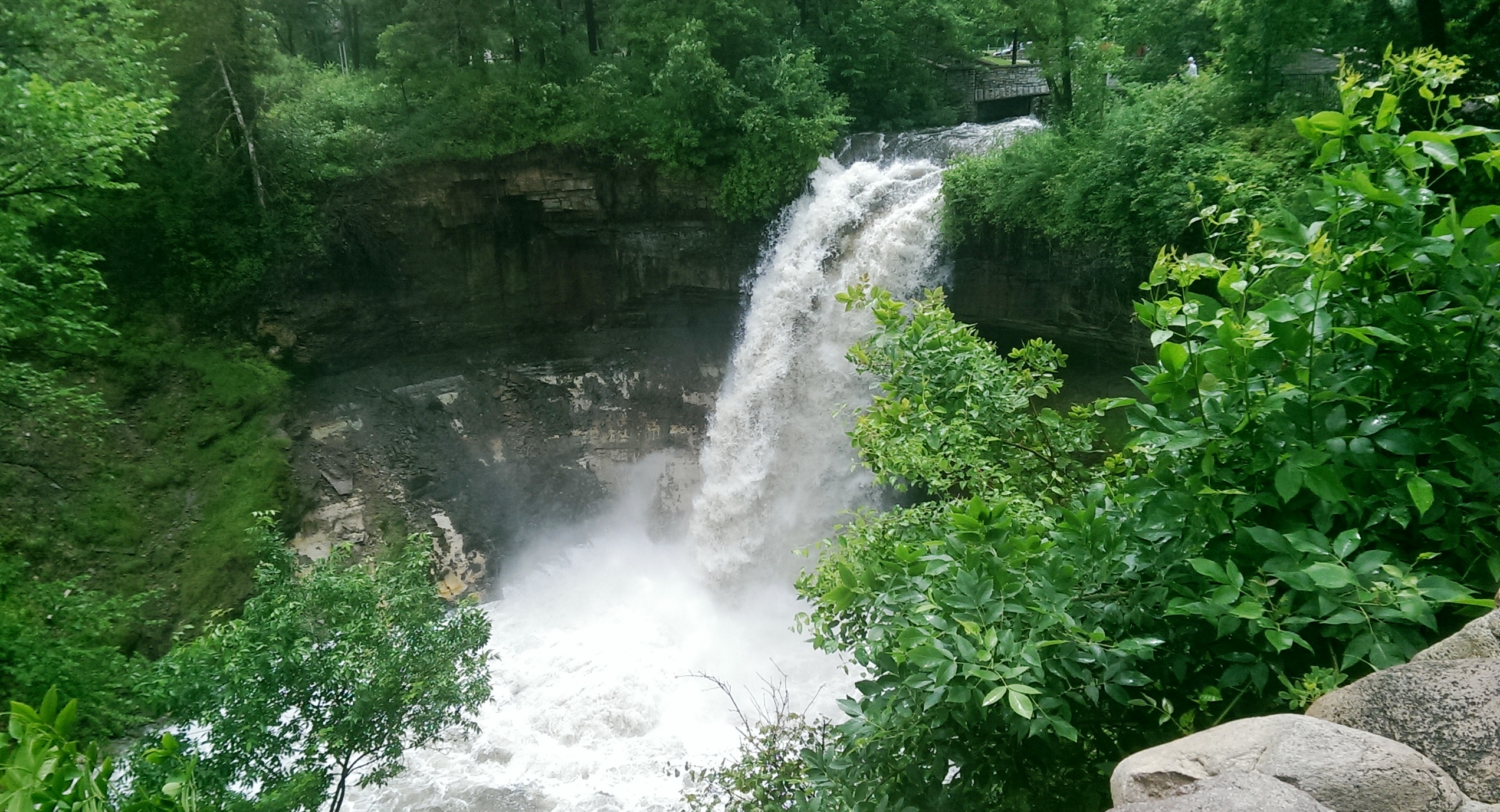
The falls made famous by Henry Wadsworth Longfellow. I recently discovered startling early plans for the park at the falls that I am waiting for permission to reveal. Stay tuned. (David C. Smith)
Unfortunately such high water levels, like the strong winds of recent years, require expensive cleanup efforts from the park board, stretching already tight park maintenance budgets. Kudos and thanks to the park board crews that will put our water-logged parks in beautiful condition yet again.
David C. Smith
© David C. Smith
Does anyone have any pictures to post of Bassett’s Creek in Theodore Wirth Park or downstream to Bryn Mawr before it dives underground? Is Shingle Creek any better?
The Worst Idea Ever #8: Power Boat Canal from Minnetonka to Harriet
Filed under: Minneapolis Lakes, Minneapolis Parks: General | Tags: 1911 Minneapolis Civic Celebration, Lake Harriet, Lake Hiawatha, Lake Minnetonka, Lake Nokomis, Minnehaha Creek, Minnehaha Falls
Comments (1) Ok, it wasn’t really a Minneapolis park project, but it still deserves a laugh: Minnehaha Creek converted into a 30-foot-wide power boat canal from Lake Minnetonka to Lake Harriet!

Lake Harriet could have been more like Lake Minnetonka.
Minneapolis was obsessed in the spring of 1911 with the upcoming Civic Celebration during which the channel between Lake Calhoun and Lake of the Isles would be opened. That was a very good thing. Huzzah, huzzah. But the attention it was drawing to the city also focused a lot of eyes on a very bad thing: Minnehaha Creek was nearly dry — in the spring! — which meant almost no water over Minnehaha Falls. Minneapolis could hardly celebrate the opening of the lake connection at the same time it suffered the ignominy of a dry Minnehaha Falls. The many out-of-town visitors anticipated for the celebration would surely want to see both. And let’s face it, a fifty-foot waterfall written about by a Harvard poet, which attracted visitors from around the world was a bit more impressive to most people than a short canal under a busy road and railroad tracks. The Minneapolis PR machine could call the city the “Venice of North America” all it wanted with its new canal, but visitors’ imaginations were still probably fueled more by the images of the famous poet’s noble heathen, beautiful maiden, and “laughing waters.”
The generally accepted solution to the lack of water over Minnehaha Falls was to divert Minnehaha Creek into Lake Amelia (Nokomis), drain Rice Lake (Hiawatha), dam the outlet of the creek from Amelia to create a reservoir, and release the impounded water as needed — perhaps 8 hours a day — to keep a pleasing flow over the falls. Unfortunately, with all the last-minute dredging and bridge-building for the Isles-Calhoun channel, that couldn’t be done in 1911 between April and July 4, when the Civic Celebration would launch.
Into this superheated environment of waterways and self-promotion stepped Albert Graber, according to the Saturday Evening Tribune, May 28, 1911. With the backing of “members of the board of county commissioners, capitalists, attorneys and real estate dealers”, Graber proposed to dredge Minnehaha Creek into a canal 30-feet wide from Lake Minnetonka to Lake Harriet. This would provide not only a water superhighway from Minnetonka to Minneapolis, and boost real estate prices along the creek, but it would also create a much larger water flow in Minnehaha Creek, solving the embarrassment of no laughing water.
“The plan, say the promoters, would enable residents of summer houses on the big lake to have their launches waiting at the town lake.”
Saturday Evening Tribune, May 28, 1911
Sure, there were problems. Not every plan could be perfect. The plan would require dismantling the dam at Gray’s Bay at the head of Minnehaha Creek, which might lower the level of Lake Minnetonka. But Graber and his backers had thought of that. The Minnesota River watershed in the area of St. Bonifacius and Waconia would be diverted into Lake Minnetonka — no problem! — which also solved another bother: it would reduce flooding on the Minnesota River.
The dam at Gray’s Bay had been operated by Hennepin Country since 1897. Many people then and now consider the dam the cause of low water flow in Minnehaha Creek, but the earliest reference I can find to low water in the creek was in 1820, when the soldiers of Fort Snelling wanted to open a mill on Minnehaha Creek, but were forced to move to St. Anthony Falls due to low water. That was even before two intrepid teenagers from the fort discovered that the creek flowed out of a pretty big lake to the west.
Graber estimated that dredging Minnehaha Creek would cost about $4,000 a mile for the nine miles between the two lakes. He and his backers, which included an officer of the Savings Bank of Minneapolis (who presumably had a summer house on the big lake and could put a launch on the town lake), provided assurances that the money to finance the project could be “readily found.”
The Evening Tribune article concluded with an announcement that meetings of those interested in the project would be held in the near future with an eye to beginning work before the end of the summer. Graber noted that his inspection of the project had been, no surprise, “superficial”, but that he would make a thorough report soon to his backers. I can find no evidence that the idea progressed any further.
The Board of Park Commissioners would have had no role in the plan, except, perhaps, allowing power boats to enter and be anchored on Lake Harriet. (I think they would have said no.) Park board ownership of Minnehaha Creek west of Lake Harriet to Edina wasn’t proposed until 1919 and the deal wasn’t done until 1930.
David C. Smith
© 2013 David C. Smith
Brownie Lake Long Ago
Filed under: Minneapolis Lakes, Minneapolis parks | Tags: Brownie Lake, Charles J. Hibbard, Theodore Wirth Park
Comments (2) As we look forward to improvements at Brownie Lake later this year and in 2013 I find it informative to look at photos of the area long ago. Of course the construction of the Prudential Building (now housing Target offices) next to the lake in 1954 changed the lake environs considerably. (See a photo of the building under construction here.) But the lake is also hemmed in by a freeway that keeps expanding on the north and a railroad/trail corridor that keeps shrinking on the south.

An undated photo labelled “Brownie Lake with Cedar Lake in the distance.” (C. J. Hibbard & Co., MPRB)
This photo puzzles me, however. If it is Brownie Lake what is the trestle on the near side of the lake in the photo? I’ve never seen that before. Can anyone enlighten me?

Charles J. Hibbard, 1916 (Minnesota Historical Society)
The back of the photo bears the stamp of C. J. Hibbard & Co. Charles Hibbard was an active photographer in Minnesota from about 1899 until his death in 1924. Those dates establish the range of years in which the Brownie Lake picture above could have been taken.
Hibbard wasn’t directly associated with parks, although many of his photos were taken in parks, but he deserves an entry of his own here some day. Based on the photos I’ve seen he was the preeminent photographer of the city. He chronicled many places and events in Minneapolis and the state. The detail and composition of his photos are remarkable.
Both of the photos below were taken at the intersection of Theodore Wirth Parkway and Highway 12 (I-394). In the first photo, a bridge is being built to carry Wirth Parkway traffic over the new four-lane highway. This photo shows the early stages of the construction of a wider highway. Notice how narrow Highway 12 was. Trees and telephone poles hug the edge of the road.

Highway 12 and Glenwood (Wirth) Parkway, 1949 (MPRB)
The second photo, also labelled as being shot in 1949, shows the progression in road building. Today’s I-394 is, of course, much wider than the four lane highway shown here. The wetland at the north end of Brownie Lake has also been filled in.

Highway 12 expands and eats into Wirth Park, 1949 (Minneapolis Star Journal, Minnesota Historical Society)
Expansion of Highway 12 into I-394 eventually took more of the parks. On the other side of the ledger, however, the wide swath of railroads in the upper third of the photo have been converted partly into bicycle trails.
David C. Smith
Bombers Over Lake Nokomis
Filed under: Minneapolis Golf Courses, Minneapolis Lakes, Minneapolis parks | Tags: Hiawatha Golf Course, Lake Hiawatha, Lake Nokomis, Wold Chamberlain Field
Comments (2) My favorite photo of Lake Nokomis was taken in 1932. The true subject of the photo was a squadron of Martin bombers visiting Wold-Chamberlain Field from Langley Field, Virginia, but beneath them is a fascinating scene of park developments.

The Martin Bomber was the first American airplane built specifically to carry bombs. First built during WWI, the biplane version of the bomber was replaced by a monoplane version designed in 1932. (Minnesota Historical Society)
The photographer isn’t listed in the Minnesota Historical Society’s database, but it may have been taken by J. E. Quigley Aerial Photography. Quigley produced most of the other aerial photos of Minneapolis from that era.
The bare ground at the left wingtip of the middle plane is the Hiawatha Golf Course under construction. The course didn’t open until 1934. Dredging in Lake Hiawatha had just been completed in 1931.
It doesn’t show up well at this size, but the Nokomis Beach is packed (beneath the front airplane). You can see the diving towers in the lake.
Also note how barren the Nokomis lakeshore is. It had been created from lake dredgings only 15 years earlier.
Four years after dredging was completed at Lake Nokomis and the dredge fill had settled, the park board cleared and graded the land. (Minneapolis Park and Recreation Board)
The dredge fill settled for four years before it was cleared of brush and willows that had grown up in the intervening years and the land was graded for athletic fields. The huge piles of brush in the background were burned. Of course the land was graded by horse teams. Even with that much time for the dredge fill to settle before it was graded, the playing fields continued to settle and were re-graded in the 1930s as a WPA project.
Even after ten years of tree growth, the lake shore doesn’t look very shaded in the 1932 photo.
The Cedar Avenue Bridge at the bottom of the aerial photo was the subject of great debate at the park board, Minneapolis City Council, the Hennepin County Board and Village Council of Richfield in the 1910s. Park superintendent Theodore Wirth’s plan for the improvement of Lake Nokomis in the 1912 annual report included rerouting Cedar Avenue around the southwest corner of the lake to eliminate a “very unsightly” wooden bridge over the edge of lake at the time. Even though the park board owned all the shores of the lake and the lake bed, the south end of the lake was then in Richfield, which is why the county and Richfield were involved in decisions on the bridge. Despite the park board position that building a bridge would be more expensive and less attractive, it was built—and paid for with Minneapolis bond funds—partly due to opposition by Richfield landowners to plans to reroute Cedar. By 1926 that line of opposition would have been partially removed when Minneapolis annexed about a mile-wide strip of Richfield that placed all of Lake Nokomis inside Minneapolis city limits.
David C. Smith
Canoe Jam on the Chain of Lakes
Filed under: Minneapolis Lakes, Minneapolis parks | Tags: Canoeing, Lake Calhoun, Lake Harriet, Lake Harriet Pavilion, Lake of the Isles, Theodore Wirth
Comments (3) The newspaper headline hinted of a sordid affair: “Long Line Waits Grimly in Courthouse Corridor.” Many were so young they should have been in school. Others had skipped work. They stood anxiously in the dim hallway, waiting. News accounts put their numbers at 500 when the clock struck 8:30 that April morning. Many had already been there for hours by then. They prayed they would be among the lucky ones to get permits to store their canoes at the most popular park board docks and on the lower levels of the lakeside canoe racks, so they wouldn’t have to hoist their dripping canoes overhead.
The year was 1912 and nearly 2,000 spaces were available on park board canoe racks and dock slips at Lake of the Isles, Lake Calhoun and Lake Harriet. Nearly all of them were needed, which represented a huge increase over the 200 permits issued only two years earlier. The city was canoe crazed.
By contrast, in 2011 the park board rented 485 spaces in canoe racks at all Minneapolis lakes, in addition to 368 sail boat buoys at Calhoun, Harriet and Nokomis.

Canoeing was extremely popular on city lakes, especially after Lake of the Isles and Lake Calhoun were linked by a canal in 1911, followed by a link to Cedar Lake in 1913. (Minnesota Historical Society)
The demand for canoe racks was so great that park superintendent Theodore Wirth proposed a dramatic change at Lake Harriet at the end of 1912 to accommodate canoeists.
Wirth’s plan (above), presented in the 1912 annual report, would have created a five-acre peninsula in Lake Harriet near Beard Plaisance to accommodate a boat house that would hold 864 canoes. The boat house would have been filled with racks for private canoes, as well as lockers for canoeists to store paddles and gear. The boat house, in Wirth’s words, “would protect the boat owners’ property, and would relieve the shores of the unsightly, vari-colored canoes.”
The board never seriously considered building the boat house and that summer the number of watercraft on Lake Harriet reached 800 canoes and 192 rowboats. Most of the rowboats and about 100 of the canoes were owned and rented out by the park board. Even more crowded conditions prevailed at smaller Lake of the Isles where the park board did not rent watercraft, but issued permits for 475 private canoes and 121 private rowboats.

Rental canoes were piled up on the docks near the pavilion at Lake Harriet ca. 1912. (Minnesota Historical Society)
The park board’s challenge with so many watercraft wasn’t just how to store them, but how to keep order on the lake. An effort to maintain decorum on city lakes began in April 1913 when another year of permits was issued. The park board announced before permits went on sale that because of “considerable agitation about objectionable names” on boats and canoes the year before, permits would not be issued to canoes that bore offensive names.
The previous summer newspapers reported that commissioners had condemned naughty names such as, “Thehelusa,” “Damfino,” “Ilgetu,” “Skwizmtyt,” “Ildaryoo,” “O-U-Q-T,” “What the?,” “Joy Tub,” “Cupid’s Nest,” and “I’d Like to Try It.” The commissioners decided then that such salacious names would not be permitted the next year, even though Theodore Wirth urged the board to take the offending canoes off the water immediately.
When the naming rules were announced the next spring, park board secretary J. A. Ridgway was given absolute power to decide whether a name was acceptable. To begin with he allowed only monograms or proper names, but used his discretion to ban names such as “Yum-Yum” even though that was the name of a character in Gilbert and Sullivan’s “The Mikado.” Even proper names could be improper.
Despite the strict naming rules, all but 75 of the park board’s 1400 canoe rack spaces were sold by late April, and practically all remaining spaces were “uppers” scattered around the three lakes.
The crackdown on canoe-naming wasn’t the end of the park board protecting the morals of the city’s youth on the water however. Take a close look at the 1914 photo below by Charles Hibbard from the Minnesota Historical Society’s collection.
The photo shows canoeists listening to a summer concert at the Lake Harriet Pavilion. Notice the width of the typical canoe and how two people could sit cozily side-by-side in the middle of the canoe. Now imagine how easy it would be to drift into the dark, get tangled up with the person next to you and make the canoe a bit tippy. Clearly a safety issue.
The Morning Tribune announced June 28, 1913 that the park board would have no more of such behavior. “The park board decided yesterday afternoon, ” the paper reported, “that misconduct in canoes has become so grave and flagrant that it threatens to throw a shadow upon the lakes as recreation resorts and to bring shame upon the city.”
The solution? A new park ordinance required people of opposite sex over the age of 10 occupying the same section of a canoe to sit facing each other. No more of this side-by-side stuff, sometimes recumbent. According to the paper, park commissioners said the situation had become one of “serious peril to the morals of young people.” Park police were given motorized canoes and flashlights to seek and apprehend offenders.
The need for flashlights became evident after seeing the park police report in the park board’s 1913 annual report. Sergeant-in-Command C. S. Barnard, referring to the ordinance that parks close at midnight, noted a policing success for the year. To get canoeists off the lake by midnight, the police installed a red light on the Lake Harriet boat house that was turned on to alert lake lovers that it was near 11:30 pm, the time canoes had to leave the lake. Barnard reported that the red light “has been a great help in getting canoeists off the lake by 11:30 p.m., but owing to the large number who stay out past that time (emphasis added), I would suggest that the hour be changed to 11 o’clock in order to enable the parks to be cleared by 12 o’clock.”
Indignant protest against the side-by-side seating ban arose immediately. Arthur T. Conley, attorney for the Lake Harriet Canoe Club, suggested that the park board show a little initiative and arrest those whose conduct was immoral rather than cast a slur on “every woman or girl who enters a canoe.” If Conley believed the ordinance was a slur on men and boys as well he didn’t say so, but he did add, “We dislike to hear that we are engaged in a sport which is compared with an immoral occupation and that we are on the lake for immoral purposes.”
In the face of protests, the new ordinance was not vigorously enforced and was repealed before the start of the 1914 canoe season. The Tribune noted in announcing the repeal that “the public did not take kindly to the ordinance last year and boat receipts at Lake Harriet fell off considerably on account of it.”
Despite the repeal of the unpopular ordinance, boating fell off even more in 1914. In the annual report at the close of the year Wirth attributed the decline partly to a terrible storm that passed over Lake Harriet on June 23 resulting in the drowning of three canoeists. Newspapers reported dramatic rescues of several others. By 1915 the number of canoe permits had dropped under 1400 even though canoe racks had been added to Cedar Lake, Glenwood (Wirth) Lake and Camden Pond.
The popularity of canoeing continued to decline. Wirth noted in 1917 that there had been a very perceptible decrease again in the number of private boats and canoes on the lakes. While he attributed that decline partly to unfavorable weather, he also noted the “large number of young men drawn from civil life and occupations to military service” as the United States entered WWI.
There were only six sail boats on city lakes in 1917, and all six were kept on Lake Calhoun. The first year that the park board derived more revenue from renting buoys for sail boats than racks for canoes was not until 1940. From then until now sailing has generated more revenue for the park board than canoeing.
The number of canoe permits leveled off for a while in the 1920s at about 1000 per year, but the canoe craze on the lakes had passed, much as the bicycle craze of the 1890s. During the bicycle craze the park board had built a corral where people could check their bikes while at Lake Harriet. That corral held 800 bicycles. At the peak of the much shorter-lived canoe craze in the 1910s, the park board provided rack space at Lake Harriet for 800 canoes. Popular number. Fortunately, the park board did not build permanent facilities—or a peninsula into Lake Harriet—to accommodate a passing fad.
David C. Smith
© David C. Smith

