Mystery Starters at Powderhorn Speed Skating Track
Filed under: Minneapolis Parks: General, Powderhorn Park | Tags: Gen. John Pershing, Pershing Park, Powderhorn Park, Speed Skating
 Comments (18)
 This photo is labelled “Olympic Speed Skating Team.” The only date on it is February 16, 1947. That seems too early to have already selected skaters for the 1948 Olympic team. Can anyone identify the skaters? Local skaters Johnny Werket and Ken Bartholomew represented the U.S. at the 1948 Olympics in St. Moritz and Bartholomew won a silver medal. Gene Sandvig and Pat McNamara represented Minneapolis and the U.S. at the 1952 and 1956 Winter Games. (I posted more about those skaters here.) They might all be in this photo.
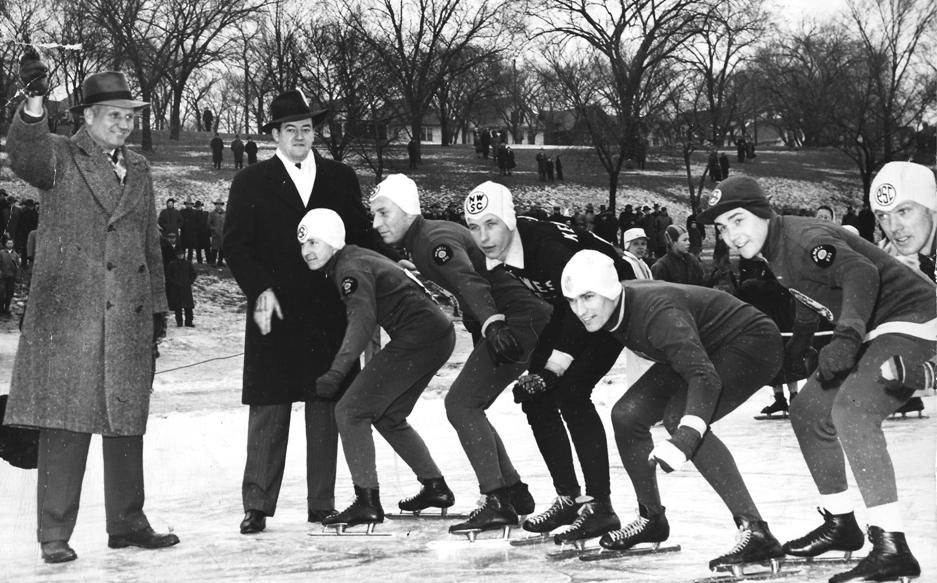
Can you identify any of these people — skaters and others — at the speed skating track at Powderhorn Park? (MPRB) (Note 9/18: Reader Tom McGrath has identified the starter and the skaters in a comment below. Thanks, Tom and Brian.)
I don’t know the skaters, but I do recognize the fellow in the dark overcoat next to the starter. Anybody know who that is — and what his job was at the time?
I don’t know the guy with the starter’s pistol, but he looks entirely too jolly to be a regular race official. Seems more like a politician holding a noisemaker, but I can’t name him.
Name them all and you get a free lifetime subscription to minneapolisparkhistory.com. (That’s the lifetime of the website, not you.) Be the first to name the man in the dark coat and I’ll email you a free, low-quality photocopy of Gen. John “Blackjack” Pershing’s letter to the Minneapolis park board in 1923 expressing his appreciation for having a park named for him. (More on that story later.)
David C. Smith
© David C. Smith
Sibley Field Flattened 1923
Filed under: Minneapolis Parks: General | Tags: Sibley Field, Sibley Park
Comments (2) Sibley Field was one of the bigger challenges the park board faced when it came to building neighborhood recreation parks. 1923 was a very busy year as the park board developed Sibley Field, Chicago Avenue (Phelps) Field and Nicollet (MLK) Field in south Minneapolis, Folwell Field and Sumner Field in north Minneapolis and Linden Hills Field in southwest. But Sibley may have been the biggest challenge, because all four corners of the park were at different grades. Park superintendent Theodore Wirth wrote afterwards that Sibley was one of the only projects for which costs had been seriously underestimated due to the expense of moving dirt. To create level fields, park board crews used a steam shovel and horse teams to move 68,000 cubic yards of earth.
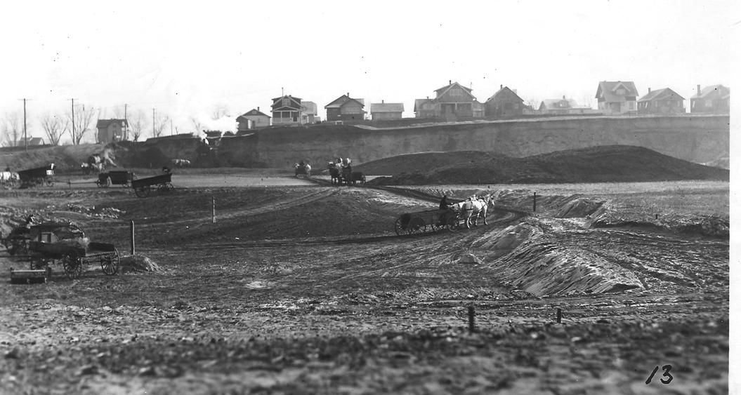
Sibley Field being levelled in 1923. (Minneapolis Park and Recreation Board)
This is one of my favorite photos of neighborhood park construction. It shows dramatically how much earth had to be moved to create an expanse of level ground suitable for playing fields. I wonder if the home owners who sat near the precipice on 20th Avenue South were ever worried.
As I noted in my profile of Sibley Field on the park board’s website, Wirth wrote in the park board’s 1923 annual report that the “formerly unsightly low land” was brought to an “attractive and serviceable” grade.
Photos like this reinforce my admiration for all the people — from neighborhood residents to city leaders — who envisioned, supported, planned and paid for the parks that have made life in Minneapolis better for many generations.
David C. Smith
Lost Minneapolis Parks: The Complete List, Part III
Filed under: Lost Minneapolis Parks, Minneapolis Parks: General | Tags: Ryan Lake, Sheridan Field, Snyder Triangle, St.Anthony Parkway, Stevens Circle, Stinson Boulevard, Virginia Triangle, Wilson Park
Leave a Comment This is the third and final installment in a series on “Lost Parks” in Minneapolis. (If you missed them, here are Part I and Part II.) These are park properties that once existed, but did not survive as parks. There is a quiz question at the end of this article. It’s very hard.
St. Anthony Parkway (partial). In 1931, the park board swapped the recently completed portion of St. Anthony Parkway from the southern tip of Gross Golf Course to East Hennepin Avenue for the land on which Ridgway Parkway was built from the golf course to Stinson Parkway. The park board gained 19 acres of land in the deal and the entire cost of constructing Ridgway Parkway was also paid. This story of the parkway “diversion” will be told in greater detail some day. It was controversial. (Read the broad outlines of the diversion of St. Anthony Parkway.) Some people have claimed that the diversion of St. Anthony Parkway is one reason for the “Missing Link” in the Grand Rounds. But that link had gone missing long before the “diversion” and wouldn’t have been found with or without the diversion.
Sheridan Field. University Avenue NE and Twelfth Avenue NE, 1.25 acres. The park board purchased the half-block of land across the street from Sheridan School for $7,000 in 1912. At the park board’s request, Twelfth Avenue was vacated between the school and park. The new playground was provided with a backstop for a baseball field and a warming house for ice-skating, but few other improvements were made. In the early 1920s park superintendent Theodore Wirth urged the park board to either expand the playground or abandon it. He believed the site was too small. It was “inadequate,” he wrote, to provide for the “large attendance (it) constantly attracts.” In the 1924 annual report Wirth presented a plan for the enlargement and development of the park, but that was the last mention of the possibility of expanding the playground. A new, much larger Sheridan School was built on the site in 1932, and the following year the park board granted the school board permission to use the park as a playground for the school, provided that all maintenance and improvements would be the responsibility of the school board. It wasn’t until 1953 that the park board officially abandoned the site. In a land swap with the school board, the park board gave up the under-sized Sheridan Park for the site of the former Trudeau School at Ninth Avenue SE and Fourth Street SE. The park at the Trudeau site became Elwell Field II.
Small Triangle. Royalston Avenue in Oak Lake Addition, 0.01 acre. The triangle was never officially named; it was called “small” because it was. Very small. (See Oak Lake.)
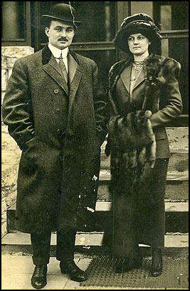
John Pillsbury Snyder and Nelle Stevenson Snyder the day they reached New York after being rescued from the Titanic. (StarTribune and Phillip Weiss Auctions)
Snyder Triangle. Fifth Avenue South and Grant Street, 0.06 acre. Purchased by resolution January 15, 1916 for $4,578. The park board had considered and rejected buying the triangle in 1886. The park was named for Simon P. Snyder, a real estate agent who once owned much of the land in the area. As Patrick Dea pointed out in a comment several months ago, Simon Snyder’s grandson, John Pillsbury Snyder, was a 24-year-old first-class passenger on the maiden voyage of the Titanic in 1912. He and his bride, Nelle Stevenson, were returning from their honeymoon — and survived. The triangle named for his grandfather did not. It was lost to freeway construction for I-35W. A triangle park exists today very near the old location, but it’s not owned by the park board. In 1967 the park board offered to help the state highway department landscape the new triangle between I-35W entrance and exit ramps and 10th Street. The old Snyder Triangle appears to be partly under the Grant Park building on Grant Street. I have not found a record of the price the little triangle fetched.
Stevens Circle. Portland Avenue and 6th Avenue South, 0.06 acre. The small park was named for Col. John Stevens in 1893, but at that time it was named Stevens Place. The name was changed to Stevens Circle on August 1, 1928. From its acquisition in 1885 to 1893 the property was called Portland Avenue Triangle. It is not known if a change in the shape of the park prompted the name change from triangle to place to circle. The park was transferred to the park board from the city council in 1885 according to park inventory lists, although there is no record of the transfer in park board proceedings. The only indication of park board ownership of the triangle was an entry in the expenditures of the park board for 1885 for “Triangle, Portland Avenue and Grant Street” in the amount of $1.50. The triangle became the home of a statue of Col. Stevens in 1911. The circle was given back to the city for traffic purposes in 1935, at which time the statue of Col. Stevens was moved to Minnehaha Park and placed near the Stevens House.
Stinson Boulevard (partial). From East Hennepin to Highway 8. 24 acres. A section of the boulevard was given to the city in 1962 because functionally it was a business thoroughfare, not a parkway. The section given to the city included all of the original land donated for a boulevard by James Stinson et al in 1885. It’s good we still have some Stinson Parkway remaining, because as I explained in the history of Stinson Parkway on the park board’s website, I think Stinson Parkway helped keep alive the plans of Horace Cleveland for a parkway that encircled the city. Without Stinson’s generosity, we might not have the Grand Rounds today.
Svea Triangle. Riverside Avenue and South 8th Street, 0.09 acre. The first mention of the triangle is in the minutes of the park board’s meeting of May 3, 1890 when the board received a request that it improve the triangle. The problem was that the park board didn’t own it. So, on June 27, 1890 the city council voted to turn over the triangle to the park board. The land had been donated to the city in 1883 by Thomas Lowry and William McNair and their wives for park purposes. The triangle was reportedly named on December 27, 1893 to honor Swedish immigrants who had settled in the neighborhood. It had previously been known simply as Riverside Avenue Triangle. The triangle was traded to the city council in 2011 in exchange for a permanent easement between Xerxes Avenue North and the shore of Ryan Lake in the northwestern corner of Minneapolis. The city council requested the exchange when making improvements to Riverside Avenue. Svea Triangle is the most recent park lost.
Vineland Triangle. Vineland Place and Bryant Avenue South, 0.05 acre. Transferred to the park board from the city council, May 10, 1912. The triangle was paved over in a reconfiguration of the street past the Guthrie and Walker entrances in 1973, but remains on the park board’s inventory.
Virginia Triangle. Hennepin, Lyndale and Groveland avenues, 0.167 acre. The triangle was apparently named for the Virginia Apartments adjacent to the triangle. The triangle was traded to the park board by A. W. French and wife on January 1, 1900 in exchange for a piece of land they had originally donated for a parkway along Hennepin Avenue. The triangle was sold in 1966 to the Minnesota Highway Department to accommodate interchanges for I-94. The price tag was $24,300, plus the cost of relocating the Thomas Lowry Monument, which had stood on the triangle since 1915. Read much more about Virginia Triangle and the monument here.
Walton Triangle. No property by this name was ever listed in the park board inventory or Schedule of Parks, but was included in the 1915-1916 proceedings in a schedule of wages for park keepers. Walton Triangle was included with Virginia Triangle, Douglas Triangle and Lowry Triangle and other properties in that neighborhood as the responsibility of one parkkeeper. This mysterious property likely got its name from Edmund Walton, a well-known realtor and developer, who lived on Mount Curve Avenue near where this property must have been located.

This photo from the Brady-Handy Collection at the Library of Congress is almost certainly Eugene Wilson when he was a Congressman from Minnesota 1869-1871. The photo by Matthew Brady is identified only as Hon. [E or M] Wilson, but resembles very closely other images of Wilson.
Other Losses to Freeways and Highways.
In addition to the parks listed above, the following Minneapolis parks were trimmed by construction of freeways:
- I-94: Luxton, Riverside, Murphy Square, Franklin Steele Square, The Parade, Perkins Hill, and North Mississippi, as well as easements for bridges over East and West River Parkway.
- I-35W: Dr. Martin Luther King, Ridgway Parkway, Francis Gross Golf Course. The highway department also acquired an easement from the park board to build a bridge over Minnehaha Creek.
- I-394: Theodore Wirth Park, Bryn Mawr, The Parade
- Hwy 55: Longfellow Gardens
I’ve only included properties that were officially acquired or improved, then later disposed of for some reason. The informal parks and playgrounds in empty lots that existed in many neighborhoods, but were never owned or improved by the park board, are not included. I’ve also left out small pieces of a few parks that were sold for various reasons over the years, other than those taken for highways.
If you can add to or correct this list, please let me know. Do you remember anything about any of these former parks? If you do, please send me a note so we can preserve something of them.
TRIVIA TEST. Here’s the Ph.D.-level park quiz question inspired by one of these entries. Two people had two completely different stretches of parkway named for them. One of those people was St. Anthony. (You could argue the parkways were named for the town, not the man, but this is my quiz.) The first parkway named for St. Anthony is now officially East River Parkway. Later the name was given to the parkway across northeast Minneapolis. Name the other person who had two different parkways named for him. Only one of them still has his name.
David C. Smith
© David C. Smith
Keewaydin Park Before and After — 1928
Filed under: Minneapolis Parks: General | Tags: Keewaydin Park, Minneapolis parks
Comments (8) Like a lot of other people I’m curious to see the new look of Keewaydin Park and School. Construction is underway. It has to be an improvement over what was there a few years ago.

Keewaydin Park before — the first time c. 1928. (Minneapolis Park and Recreation Board)
Okay, it was a long time ago. In 1928-29 the park board hauled in 38,600 cubic yards of fill to bring the playing fields up to grade on one side. Clearly the neighbors tried to help by discarding their refuse there, too. The crate says “Morell’s Pride Hams and Bacon.” But that wasn’t enough; the fill kept settling. The park board continued to fill the former swamp in 1930-31. By 1932 the field had been filled sufficiently to be regraded and have tennis courts and a wading pool finished. By 1934 the grounds looked much nicer.
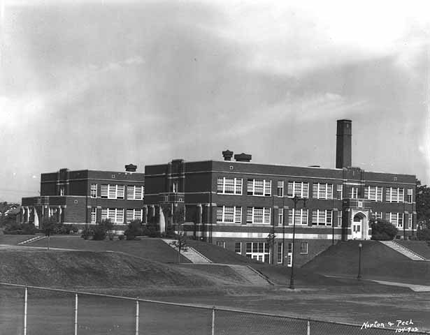
Keewaydin School and surrounding park in 1934. (Norton and Peel, Minnesota Historical Society)
Keewaydin was one of the early collaborative projects between the park and school boards. In the park board’s 1929 annual report it noted that the park had one of the best-equipped shelters for skating and hockey rinks due to the “well-appointed” basement rooms of the school. The doors on the lower level in this photo must have been the entrance to those rooms.
Anybody remember skating there or going to school there when it was new? Does anybody want to take a photo of present construction and email it to me? I forgot to zip over and take one Sunday when I was at Longfellow House.
David C. Smith
Lake Harriet Toboggan Slide
Filed under: Minneapolis Parks: General, Winter Sports | Tags: Lake Harriet, toboggan slide
Comments (8) As the heat continues to burn grass and crops this summer, I’ll provide cool respite on the edge of Lake Harriet. Fred Perl, the park board’s forester, took these photos of the Queen Avenue toboggan slide at Lake Harriet in 1914.

Looking up toward Queen Avenue on the western shore of Lake Harriet. (MPRB)
Check out the canoe racks that line the shore.
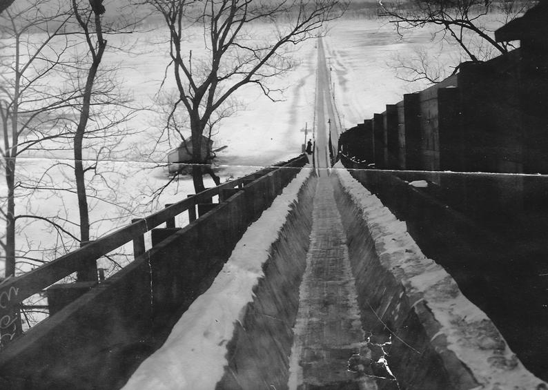
The view from the top of the slide along Queen Avenue above the street car barn. (MPRB)
The views from top and bottom are cool, but they don’t show all the work that went into building this slide. You can only appreciate that from a side view.
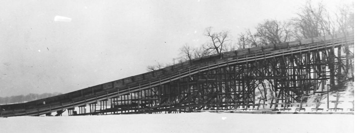
The impressive structure of the Lake Harriet toboggan slide. Note the passage made for cars on the parkway through the lattice. (MPRB)
Feel any cooler?
David C. Smith
Lost Minneapolis Parks: The Complete List, Part II
Filed under: Lost Minneapolis Parks, Minneapolis Parks: General | Tags: Hennepin Avenue, Lyndale Avenue, Lyndale Farmstead, MIssissippi Park, Oak Lake, Pioneers Square
Comments (7) This is Part II — H-R — of an alphabetical list of “lost” Minneapolis parks. These are park properties that were officially acquired or improved by the park board, but then were sold or given away. (If you missed Part I — A-G — click here.)
Hennepin Avenue South. 17.5 acres. The main parkway link from the city — Loring Park — to Lake Harriet was supposed to be Hennepin Avenue. The park board spent considerable effort and money to establish Hennepin Avenue as a parkway, beginning in 1884, but it was too heavily used as a commercial route and thoroughfare to be the beautiful and tranquil parkway the park board desired. Instead, Charles Loring created a route to Lake Harriet out Kenwood Parkway, then around Lake of the Isles and Lake Calhoun, an integral part of what would become the Grand Rounds. The park board returned ownership of Hennepin Avenue South, from Lyndale to Lake Street, to the city in 1905. I’ll write more of the Hennepin Parkway story eventually.
Hiawatha Triangle. Minnehaha Avenue and East 32nd Street, 0.5 acre. Purchased September 6, 1910 for $2,975. In 1960, the City Planning Commission informed the park board that the triangle was to be rezoned, probably as residential. I don’t know if that played a role in the subsequent sale of the property. On September 7, 1960 the park board accepted bids on several parcels of land, including an oral bid by Lawrence Hauge of $35,500 for Hiawatha Triangle, or Lots 1-4 of Block 7, Rollins Addition. Hauge’s bid was accepted. He purchased the land for what became McDivitt-Hauge Funeral Home.
Highland Oval. Highland Avenue in Oak Lake Addition, 0.058 acre. (See Oak Lake.)
Hillside Triangle. Hillside Avenue and Logan Avenue North, 0.6 acre. Transferred from the city council September 20, 1892. The park board granted a request from the school board to use the triangle as a playground for Lowell School in 1921. Title for the land was transferred to the school board in 1953. Lowell School closed in 1974. Houses were built on the former triangle and school site.
Iagoo Triangle. Hiawatha Avenue and East 45th Street, 0.05 acres. Donated to the park board by William Adams and wife, March 17, 1886, along with Osseo Triangle. The triangle was named for the story-teller in Longfellow’s The Song of Hiawatha. Sold to the Minnesota highway department in 1966 for the proposed Highway 55 freeway. The purchase price is not contained in park board records.
Kenwood Triangle. Penn Avenue South, Oliver Avenue South and West Franklin Avenue, 0.02 acre. Transferred from the city council to the park board June 3, 1907 when Kenwood Park was acquired. This is another triangle still on park board books, but listed as “paved.” The traffic intersection was altered in 1981, when the park board and school board collaborated on the construction of the recreation center attached to Kenwood School.
Lakeside Oval. Lakeside Avenue in Oak Lake Addition, 0.32 acre. (See Oak Lake.)
LaSalle Triangle. LaSalle Avenue and 13th Street South, 0.05 acre. Transferred to the park board from the city council June 7, 1922. The triangle was returned to the city in 1976 as a part of street reconfiguration.
Longfellow Field I. Minnehaha Avenue and East 26th Street, 4 acres. Purchased in 1911 for about $7,000. Sold in 1917 for $35,000. That’s only the beginning of the story. Read the rest and see more photos here.
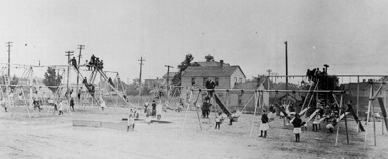
The playground at the first, “lost” Longfellow Field in 1912. (Minneapolis Collection, Hennepin County Library)
Lowry Triangle. Hennepin, Lyndale and Vineland Place, 0.16 acre. Transferred from the city council November 28, 1891. Lost to I-94 in 1964. See much more detail here. The highway department’s initial offer of $1,500 for the triangle was rejected by the park board and the board instructed its attorney to oppose that valuation in court. By September 1967 the offer for the triangle had increased to $5,000 and the park board still wasn’t biting. Park board proceedings and annual reports never reported the final sale price of the property. Someday I’ll look through Hennepin County records to see what I can find.
Lyndale Avenue North. 16.65 acres. Lyndale Avenue North was intended to be the primary parkway into North Minneapolis in what later became known as the Grand Rounds. It was too much a commercial avenue ever to serve the purpose of a parkway connecting Loring Park to Farview Park, however. After twenty years of trying to make it a parkway between Western (Glenwood) Avenue and 29th Avenue North, the park board gave up and turned it over to the city to maintain as an ordinary street in 1905. The park board abandoned Hennepin Avenue South at the same time.
Lyndale Farmstead (partial). The half-block south of West 40th Street between King’s Highway and Colfax Avenue, 1.78 acres. Acquired from James J. Hill and Thomas Lowry in 1909 as part of the land donated for a superintendent’s house. Theodore Wirth recommended selling the land in the 1912 Annual Report and using the proceeds to build a laundry at the Lyndale Farmstead shops for washing the napkins and table cloths from park refectories, and towels and swimming suits from the bath houses. Other uses were later proposed for revenue from the sale of the 14 lots platted there. In 1922 the board decided to sell the lots, asserting that no park use was ever intended for that land. All of the lots were sold by 1925. Annual report figures for those years only show revenue of $17,155 from land sales, but that likely understates total revenue as the lowest listed sale price I can find for any single lot was $1,750. All revenues from sales went into a fund for the operation and improvement of Lyndale Farmstead. Curiously, in the midst of the sale of those lots, Wirth published a plan for the improvement of Lyndale Farmstead in the 1924 Annual Report that included building four tennis courts at the corner of King’s Highway and West 40th St.
Market Square. Main Street and today’s Central Avenue. Transferred to the park board April 27, 1883. The city council had acquired the land in exchange for the assistance it had provided in constructing a dam to protect St. Anthony Falls. On January 22, 1886 the city council voted to cede the land to the Minnesota Industrial Exposition as part of the ground to be used for an Industrial Exposition Building.
Midway Triangle. University Avenue and Bedford Street SE, 0.03 acre. Acquired from the city council, October 1, 1919. The park board noted at its meeting November 1, 1944 that the triangle had already been paved over as part of the widening of University Avenue and, therefore, transferred title back to the city council. See more detail on this and other Prospect Park triangles here.
Mississippi Park. Land was lost on both sides of the Mississippi River when the Meeker Island Dam and later the Ford Dam were built. The park board also lost several islands in the river, including Meeker Island, which were submerged in the reservoirs behind the dams. The story of the construction of the dams and their impact on Minneapolis parks deserves more detail than I can give it here. The west side of the river gorge from Franklin Avenue to Minnehaha Park should be named for Horace William Shaler Cleveland, the man who did so much to ensure that the river banks became a park.
Oak Lake. Lakeside and Border avenues in Oak Lake Addition, 1.33 acres. Oak Lake and other parks in the Oak Lake Addition — Highland Oval, Lakeside Oval, Royalston Triangle and Small Triangle — were donated as parks in the original plat of Oak Lake Addition by Samuel C. Gale et al., October 22, 1873. The Farmers’ Market on Lyndale sits on what was once the first Minneapolis lake to become a park. (The story of the little lake and Oak Lake Addition is fascinating. I’ll re-post it someday soon.)
Oak Street Triangle. Officially part of East River Parkway at Oak Street, but known as Oak Street Triangle. Sold to U of M in 1961 for a price that is not recorded in park board records.
Osseo Triangle. Hiawatha Avenue and East 46th Street, 0.03 acres. Donated by William Adams and wife, March 17, 1886 along with Iagoo Triangle. In keeping with the Longfellow theme in the neighborhood named for him, the triangle was named for another character in The Song of Hiawatha; Osseo was the Son of the Evening Star. Sold to Minnesota Highway Department for Highway 55 freeway in 1966 for an unknown price.

The dedication of Pioneers Square in front of the post office was held November 13, 1936 to honor, Charles M. Loring, the “Father of Minneapolis Parks.” It would have been his 103rd birthday.(Minnesota Historical Society)
Pioneers Square. Marquette Avenue and Second Street South, across from the post office, 2.5 acres. The land was purchased and developed by the park board at the request of the city council. The U. S. Postal Service wanted to construct a new post office in downtown Minneapolis, but insisted that it be set in attractive environs, a park. The park board rejected the plan of the city council to assess the nearly half-million dollar cost of acquisition, demolition and improvement mostly on the surrounding property owners at the onset of the Great Depression in 1930. The park board finally agreed to the deal in 1932 when the city council authorized $320,000 in bonds to cover about 80 percent of the cost of the land. The remaining costs were assessed on property owners.

The Pioneers Statue being assembled in front of the new post office.
The new post office and Pioneers Square — and The Gateway, a couple blocks west — did not lead to urban renewal in the area. (With the snow melt at the end of the winter of 1953, maintenance crews picked up 70 bushel baskets of empty wine and whiskey bottles from The Gateway. One Monday morning in the summer of 1953, crews picked up 62 empty wine and whiskey bottles from the grass at Pioneers Square. [Charles E. Doell Papers, Hennepin History Library]) The city condemned Pioneers Square and The Gateway in 1960 in a new round of urban renewal. The Pioneers Monument was moved to a small triangle in northeast Minneapolis in 1967, which the city sold to the park board for a dollar. The statue was moved across Marshall Avenue to the B. F. Nelson park site in 2011.
Rauen Triangle. Eleventh Avenue North and Fifth Street, 0.027 acre. Purchased in 1890. Turned over to the city in 1939. (See more of the story and photos here.)
Royalston Triangle. Royalston Avenue and 6th Avenue North in Oak Lake Addition, 0.20 acre. (See Oak Lake.)
I’ll post Lost Minneapolis Parks: The Complete List, Part III soon.
Do you remember anything about any of these former parks? If you do, send me a note so we can preserve some recollection of them.
David C. Smith
© David C. Smith
Let’s Tell Stories: Longfellow House, Sunday, July 22
Filed under: Minneapolis parks, Minnehaha Falls | Tags: Longfellow House, Minnehaha Park
Leave a Comment The park board is turning back the clock at Minnehaha Park, Sunday, July 22 to have some fun with the way things used to be. As a part of the yesteryear theme, I’ll be at the Longfellow House 1-4 p.m to talk about the history of the park and sign copies of City of Parks. I believe the book will be for sale, too.
At 2:30 pm I’ll give a short presentation about the history of Minnehaha Park. I’ll tell you why Minneapolis asked the state legislature in 1885 for 1,000 acres in the vicinity of the park — and why the legislature only approved 200 — and didn’t pay for it anyway.
Please come by and introduce yourself.
David C. Smith
Lost Minneapolis Parks: The Complete List, Part I
Filed under: Lost Minneapolis Parks, Minneapolis Parks: General | Tags: Brownie Lake, Elwell Field, The Gateway, Theodore Wirth Park
Comments (3) I’ve written about several parks in Minneapolis that are no more. Since then I’ve been asked if there is a list of those “lost” parks. The short answer is, “Not until now.” Here’s the first part of an alphabetical list I’ve compiled from park board proceedings and annual reports.
19th Avenue South and South 1st Street. 1.0 acre. The park board’s 1948 annual report noted that the site near Seven Corners had been graded and frames had been installed for swings, teeter-totters and slides for small children. The plan was to complete the playground in 1949. This parcel was leased specifically for use as a playground. I don’t know the terms of the lease, but it was still included in park inventory as leased land in the 1964 annual report. The U of M’s West Bank softball fields are now near the site. 19th Avenue South at that point is the approach to the 10th Avenue Bridge over the Mississippi River.
Bassett Triangle. 7th Avenue North and 7th Street North, 0.03 acre. Acquired from the city council December 3, 1924. Returned to the city council in 1968, after the board hired appraisers in 1967 to try to sell the property. The site is now occupied by a Wells Fargo Bank. The property was named for Joel Bean Bassett, who owned much of the land in the vicinity in the 1800s. Bassett’s Creek, underground not far away, is also named for him.
Bedford Triangle. Orlin Avenue SE and Bedford Avenue SE, 0.01 acre. This little triangle in Prospect Park was still carried on the park board’s inventory the last time I checked, but it was listed as “paved.” There is no visual evidence of the triangle. Read more about this and other triangles in the meandering streets below Tower Hill.
Brownie Lake (partial). Theodore Wirth Park west of Brownie Lake and south of Highway 12, 32 acres. The land was sold in 1952 to the Prudential Insurance Company for $200,000 and some additional land.
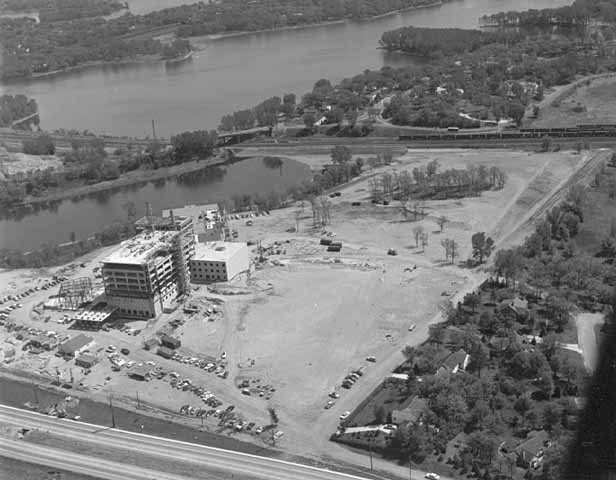
The southern end of Theodore Wirth Park west of Brownie Lake got a makeover when the Prudential Insurance Company purchased the land for its regional headquarters in 1952. It was the largest section of park land the Minneapolis park board has ever sold. Construction is underway in this 1954 photo. (Minneapolis Star Journal Tribune, Minnesota Historical Society)
The park board bowed to intense public pressure to sell the land beside the lake. Prudential had made it clear that the site adjacent to the lake was the only site it would consider for its offices in the city. Ultimately the park board was convinced that the benefit to the Minneapolis economy was a greater good than keeping the land as a park. The board justified its action in part by asserting that with the growth of traffic on Highway 12 (now I-394) and the widening of that road, the land west of Brownie Lake had already been isolated from the rest of Wirth Park anyway.
Cedar Avenue Triangle. Cedar Avenue and 7th Street South, 0.02 acre. The triangle was offered to the park board by Edmund Eichorn on April 15, 1891. After delaying a decision for a couple of months, the board agreed to pay Eichhorn $2,394 over ten years without interest. The triangle, adjacent to what is now the Cedar Avenue exit ramp from I-94 westbound, was sold to the state highway department in 1965 for $1,000. In April of that year the board approved a resolution to sell the property for $1,000 plus “other valuable considerations.” Later that year the board approved dropping the “other valuable considerations” clause.
Crystal Lake Triangle. West Broadway and 30th Avenue North, 0.05 acre. The triangle was supposedly purchased July 21, 1910 and sold to the state in 1962 for $2,700. It once sat at the edge of what is now the hideous intersection of Theodore Wirth Parkway, West Broadway (County Highway 81) and Lowry Avenue. Imagine if Phelps Wyman’s 1921 plan for that complex intersection had been used. What a difference it would have made in that part of Minneapolis. It would’ve been gorgeous.
Dell Place. Dell Place between Summit and Groveland avenues, 0.04 acre. Transferred from the city council April 27, 1883 when the park board was created. Citizens near the tiny lot petitioned the park board in 1907 to plant and maintain the grounds, which the park board agreed to do — if residents of the area would first pay to have the parcel curbed and filled to street grade. The street triangle was sold to the Minnesota highway department for I-94 interchanges in 1964 for $1,350. The park board had rejected the state’s first offer of $450. The park board’s appraisers valued the land at $2,250, but the park board accepted an internmediate figure instead of proceding to court with litigation.
Elwell Field I. East Hennepin and 5th Avenue SE, 3.7 acres. Purchased in 1939 from the Minneapolis Furniture Company for $5,000. Sold to Butler Manufacturing in 1952 for $55,000. The somewhat isolated field, surrounded by industrial buildings, was sold with the promise to the neighborhood to acquire another playground nearer Holmes School. Eventually the land adjacent to the school was purchased as a playground. The school on the former Holmes site, built in 1992, is now named Marcy Open School.

The first Elwell Field, 1952. Across the field is a building of the Butler Manufacturing company, which purchased the field the year the picture was taken. (Norton and Peel, Minnesota Historical Society)
Elwell Field II. 9th Avenue SE between SE 4th Street and SE 5th Street, 1 acre. The former site of Trudeau School was acquired February 4, 1953 in a trade with the school board. The park board gave up Sheridan Field next to Sheridan School at Broadway and University Avenue NE for the Trudeau property. The second Elwell Field was condemned by the state highway department for I-35W in 1962. The park board accepted a negotiated payment of $125,000 for the park in 1966.
Franklin Triangle. Franklin Terrace and 30th Avenue South, 0.05 acre. Transferred to the park board from the city council August 13, 1915 and accepted and named by the park board September 6, 1916. Taken by the state highway department for I-94 in 1962 in exchange for $1 and “other valuable considerations” again.

The beautiful cover of the park board’s 1915 annual report depicted the fountain at The Gateway. (Minneapolis Park and Recreation Board)
The Gateway. Hennepin and Nicollet avenues, 1.22 acres. There is still a Gateway park property at Hennepin and 1st Street South, but it’s not in the same location, so I consider this original Gateway a lost park. I have already provided the outline of the story for the original Gateway on the history pages of the Minneapolis Park and Recreation Board’s website at minneapolisparks.org.
Groveland Triangle. Groveland and Forest avenues, 0.21 acre. The triangle was purchased in November 1910 for $8,979. It was sold to the state highway department for the construction of I-94 in 1964 for $8,900.
That’s all for Part I of Lost Minneapolis Parks. Part II — H-R — will be out soon.
Historical profiles of all existing Minneapolis parks can be found at the website of the Minneapolis park board. Each park has its own page with a “History” tab.
If you remember anything about any of the lost parks mentioned here, please send me a note so we can preserve something of those parks — especially the property beside Brownie Lake. Any memories before Prudential moved in?
David C. Smith
© David C. Smith
Minneapolis speedskating: Bearcat 8mm film from 1950s
Filed under: Minneapolis parks, Winter Sports | Tags: Powderhorn Park, Speed Skating
Comments (4) Adam Martin has posted some fun 8mm film footage of the Bearcat American Legion Post speedskating team in Minneapolis from the 1950s on youtube.

Bearcat American Legion Skating Team. Appears to have been taken at Powderhorn Park. (Adam Martin)
Adam’s father—John—and uncles—Jim, Tom and Michael—skated for the Bearcat team, as he related in a recent comment on my first speedskating post.
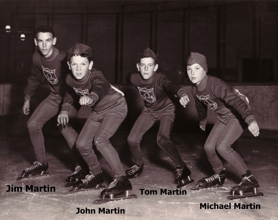
The Martin brothers who skated for the Bearcat team in mid-1950s. (Adam Martin)
Have a look at that post as well as others on speedskating, then click this link (or the youtube.com link in Adam’s comment): http://www.youtube.com/watch?v=c8ewShuJeEo
The first clips were shot at Powderhorn, I believe, but I don’t recognize where the clips at the end were from. Can anyone identify the other rinks featured — or tell us anything else about the clips Adam has provided?
Thanks, Adam.
David C. Smith
P.S. I just heard from Adam that his uncle identified the last clips as being shot in Winnipeg.
Minneapolis Park Memory: Ode to Webber Pool
Filed under: Minneapolis Park Memory, Webber Park | Tags: Minneapolis parks, Webber Park, Webber Pool
Leave a Comment I am an ex-competitive swimmer. I bought my house in 1996, a half block up the hill from Webber Park on Colfax because it was close to the pool. At that time I was working second shift, so I was able to swim laps at their morning time slot. For two and a half months in a glorious Minnesota summer I was able to swim my laps outside! It wasn’t summer until the pool opened and I was always sad to see it close. I bought a season pass each summer, often being the first one to do so. I’ve made some great friends through swimming at Webber Pool. Even made acquaintances there, people I only saw at the pool. I taught my son how to swim there.
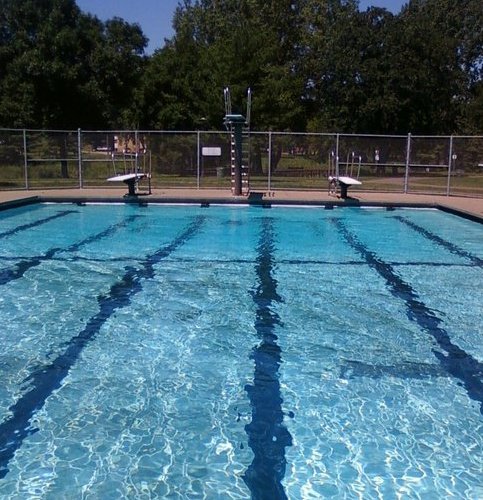
This was my view as I started my laps each morning. I could sit there at the edge of the pool just thinking about whatever, usually not the swim I was about to do. Water is a thought provoking substance. Chris Norman
Most of the time, the park was not safe to be in, especially in the evening. I was once in the middle of a shooting with my son in a stroller, returning home from the baby pool near the community center. But the big pool was always safe.
After the city made Rosacker and North Commons into water parks, Webber Pool was the only ‘real’ pool left in the city. Water parks are fun, but they don’t allow for swimming. Webber had three diving boards, a shape that allowed for lots of wide open fun. Twenty-five meters for laps. It could get pretty wild and crazy on hot afternoons. Weekend mornings were perfect peaceful times to relax, enjoy the sun and water.
Outdoor pool water sparkles. I can dive under, lay on the bottom, look up at the sky and see prisms. It’s a magic world.
I moved after eight summers, to raise my son in a safer area, but we came back every summer on an almost daily basis to swim. Each summer we were thankful it was opening again. I know it was old and I know how expensive it is to repair, and I know the city didn’t make money on it. But some things are priceless and this pool was a gem.
I fail to see how the city couldn’t update the park and keep the pool intact.
Chris Norman
Thanks for the memory, Chris
David C. Smith
Toros Ready For Work
Bob Wolff from Toro provided three great old photos of Toro products at work in Minneapolis parks. (See previous stories here and here.)
The first two are tractors from 1939 on East Nokomis Parkway.

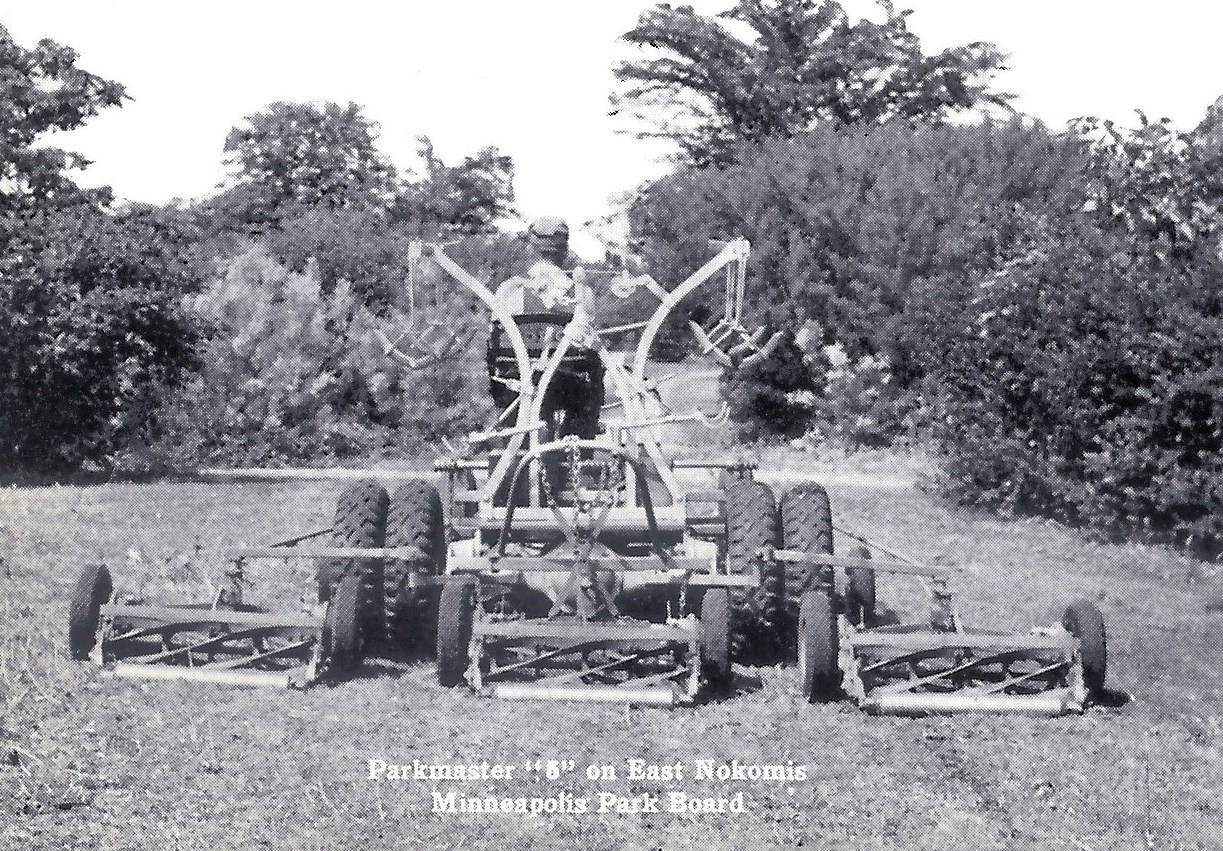
(Courtesy The Toro Company archives)
But best of all is this fleet of power reel mowers circa 1930. I love this picture. Can anybody identify any of the maintenance people in the photo? Every man wears a hat.
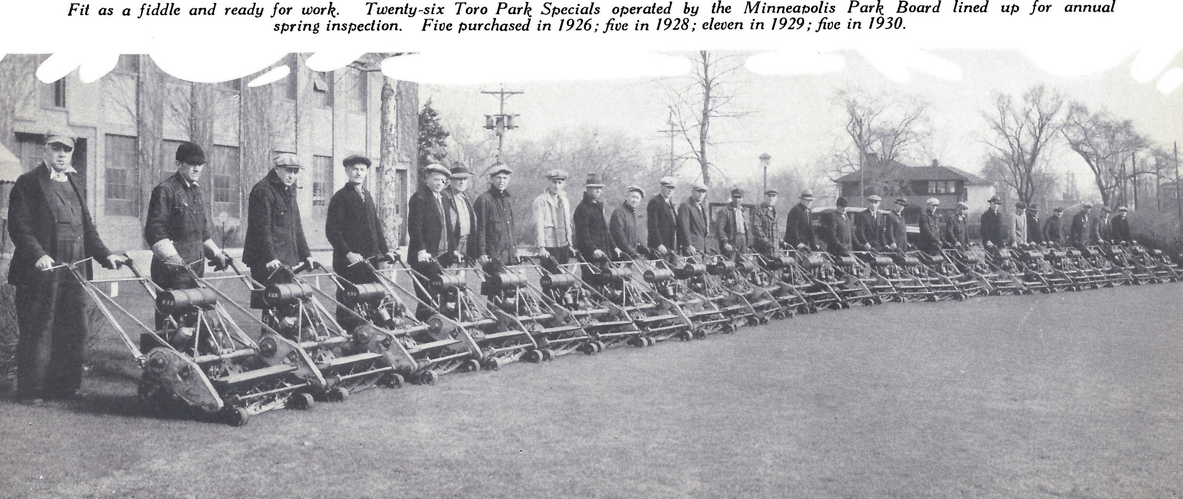
(Courtesy The Toro Company archives.)
Thanks, Bob
David C. Smith
The True Story of Sibley Triangle, by Robin Russell
Filed under: Minneapolis parks | Tags: Minneapolis parks, Northeast Minneapolis, Robin Russell, Sibley Triangle
Comments (3) I started tending this garden in 2006, but really took it on in 2007. In 2007, I was living in St. Anthony East neighborhood, and I lost my home to foreclosure. I didn’t want to leave my perennials behind, so I moved them to the triangle. In this same time period, another house in the neighborhood was demolished after a fire, and I was disappointed to learn that when that happens, any perennials or shrubs are ripped out, too. In 2007-2008 time period a lot of houses were being razed on primarily the North Side, so I got hold of the list of properties to be razed and went ‘plant rescuing’ before the bulldozers got in. I remember one afternoon it seemed like me and the bulldozers racing around the streets together! For awhile I kept a blog of my ‘guerrilla gardens’ (haven’t been able to keep up with it that past two seasons) and for the purposes of that blog, I dubbed Sibley Triangle “Foreclosure Park.” There are a number of really great specimens in the garden that I got from these rescue trips. Especially the ‘Hope for Humanity” rose. Well, maybe it’s not that variety, but I don’t want to hear about it. I like thinking it’s a Hope for Humanity. It seems fitting.
Before I took over the park, it had been abandoned for quite some time. Before that, St. Anthony East had a neighborhood garden group that installed the granite pavers and built the raised bed. The indigo baptisia is the plant that remains from this group. Water had been provided by ‘Phil,” a nearby homeowner, but after he either passed away or moved away, and there was no easy water access, the park was no longer cared for by this group. This is why I am such a pusher and shaker when it comes to making sure we continue to have affordable water for this space. Downtown in the water permits department I have been referred to as “the particular woman with the particular garden!” LOL. I am copying Kathy Kittelson on this e-mail as she was part of the aforementioned gardening group and she may have pictures.
I was told that when Our Lady of Lourdes parochial school was across the street from the Triangle (where the public housing building is now), that the Triangle had marble pits where the kids (probably boys) played marbles. I was told that if I kept digging, sooner or later I would find marbles, and in fact I have two that I have found there! If there is a way to get pictures of Our Lady of Lourdes School, maybe there would be pictures of the Triangle there. That would be a fun research project.
It is such an honor to take care of this space. It is really cherished by the neighbors, and is a destination spot that people now walk to. I learned that one neighbor even referenced it as a neighborhood amenity to a new tenant in the area!
My blog is guerrillagardensne[dot]blogspot[dot]com
Robin Russell
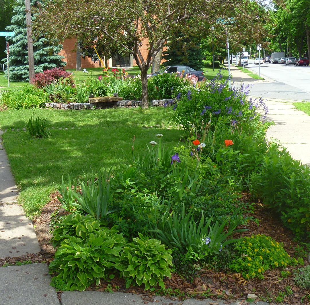
Another view of Robin’s garden from my May 30 visit. David C. Smith
NOTE: Thanks so much, Robin, for telling the story and for taking care of a space that we all can enjoy.
Does anybody have any photos of Our Lady of Lourdes school—or know of any? Let me know where I could find them, or send them to me and I’ll post them here.
David C. Smith
 Minneapolis Park History