Connecting Lake Harriet and Lake Calhoun
Imagine a canal between Lake Harriet and Lake Calhoun. It nearly happened long before Minneapolis had a park board. If that canal had been built when it was first authorized, in 1879, Lake Harriet and Lake Calhoun may never have become parks. All we would know of those lakes today might be from a public access landing for boats. Imagine Lake Harriet and Lake Calhoun like Lake Minnetonka with mansions, Mc and real, within a spit of the water, a private lake instead of a public one. But let’s back up.
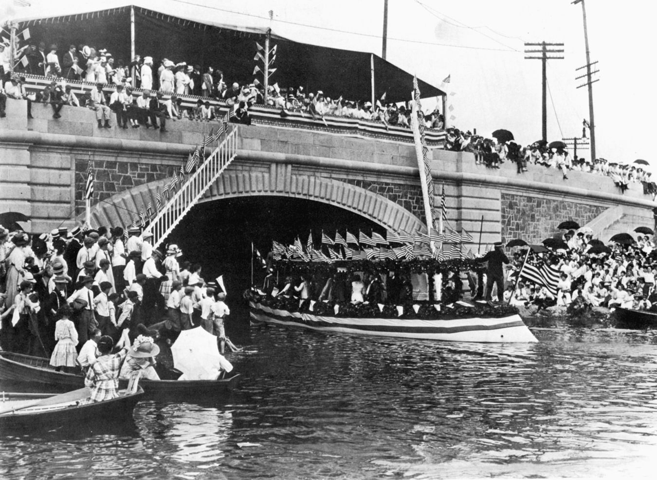
One of the great events in Minneapolis in the early 1900s was the connecting of Lake of the Isles with Lake Calhoun by a canal in 1911. The “Linking of the Lakes” was the centerpiece of a week-long civic celebration. A famous cartoon from a newspaper of the time depicted the event as a wedding of the waters. One park commissioner commented that linking Isles and Calhoun by a navigable waterway, soon to be followed by similar links to Cedar Lake and Brownie Lake, would make Minneapolis the “Venice of the north.” A bit over the top, but it demonstrates the pride of the park board and the city in its shaping of the cityscape. A national competition with an $800 prize, significant money, had even been held to design the bridge that carried Lake Street and the parkway over the channel. It was a big deal—partly because the park board had just spent four years and quite a bit of money dredging Lake of the Isles into a real lake instead of a swamp.
The plans to connect the two lakes were created by park superintendent Theodore Wirth at the direction of the park board in 1907. But, as noted in the history of Lake Calhoun as a park at minneapolisparks.org, the idea of connecting lakes had been around for about twenty years, dating to the time the park board was negotiating with the Dean family (as in Dean Parkway) to acquire land between Isles and Calhoun in the late 1880s.
That’s as much as I knew of plans to link lakes until I stumbled across an interesting piece of legislation. The first plan to connect lakes didn’t involve Lake of the Isles at all. It would have linked Calhoun and Harriet.
On March 8, 1879 the Minnesota legislature passed Special Law 193, which gave the Lyndale Railway Company extraordinary powers. Section 2 of that act stated, in part:
[The] Lyndale Railway Company, its successors and assigns, are hereby authorized and empowered to construct a canal by the nearest practicable route to connect the waters of Lake Calhoun and Lake Harriet aforesaid, which canal shall commence near the outlet of Lake Calhoun and end near the inlet of Lake Harriet, and may be constructed wide enough and deep enough for steamboats, or boats propelled by other power than steam, to pass through the same, and with all necessary locks and other necessary or convenient contrivances for the safe and convenient navigation and use of said canal, and may at any time widen, deepen, alter or change the course of said canal, and may forever use, navigate, own and control said canal, its inlet and outlet, and all rights, franchises, interests and appurtenances in any way thereto belonging, and rights, privileges and franchises in this act granted, and authorized, necessary or convenient for the proper construction, alteration, use and enjoyment of said canal, its rights, franchises, interests and appurtenances…
The act also authorized the company to build a dam at the outlet of Lake Harriet to raise the level of the lake another foot, if property owners around the lake gave their permission!
An article in the Minneapolis Tribune on March 17 detailed the extensive plans of the Lyndale Railway Company to develop Lake Calhoun. The company was building a railroad out First and Nicollet avenues from downtown Minneapolis then west along present day 31st Street across Hennepin Avenue then southwest to Lake Calhoun. The company also owned the pavilion that had been built along the lake near what would be the terminus of the railroad.
The company’s plans for the area included a three-quarter mile long canal to connect the lakes, featuring a lock to negotiate the nearly seven-foot drop in elevation from Calhoun to Harriet. The lock would provide, the Tribune said, a “novel” experience for “a great many pleasure seekers.” Also planned were a boat house and bath house on the shore, a drive around the lake, and subdivision of the land around the pavilion—from Lake Street to 36th, Hennepin Avenue to Lake Calhoun—into lots for housing. Among those said by the Tribune to be considering building homes there were “Architect” Buffington, George Brackett and Col. Robert Innes, an officer of the railway company. The paper reported that the streets in the area would follow the natural contours of the land and were difficult to describe without a diagram. In other words, the streets planned then were not in the grid pattern that was eventually laid out. (This sounds suspiciously like something Horace Cleveland would have designed—like Tangletown near Minnehaha Creek—but I have come across no evidence of Cleveland’s involvement in this project.)
Fortunately for our enjoyment of the lakes today, the grandest plans of the Lyndale Railway Company never materialized. Instead of developing the area around Lake Calhoun, the company focused effort and investment on extending its track, first to Lake Harriet, then Lake Minnetonka. It is not hard to imagine that if the railway had focused on developing amenities around Lake Calhoun and Lake Harriet that the shores of the lakes may have become too expensive for their eventual acquisition by the park board.
The “brilliant success” of the new railway, wrote the Minneapolis Tribune on June 30, 1879, “practically makes Lake Calhoun and Lake Harriet the summer garden of Minneapolis.” The area around the pavilion at Lake Calhoun was referred to as “Lyndale Park.” Col. William McCrory, president of the railroad, told the Tribune on October 6, 1879, after a very lucrative summer of operation, that the railway had saved Minneapolis four times what the railroad had cost to build. “For a long time,” McCrory said, “people have been clamoring for a public park and a park would sooner or later have to be provided. Now they say ‘Go to thunder with your park!’”
The railway eventually became mired in legal battles, sloppy management—which made its service unreliable—and claims that its steam “motors” constituted a “nuisance.” And it eventually lost a battle with Thomas Lowry’s street railway company for the routes to the lakes. Its grand plan for developing a portion of Lake Calhoun and Lake Harriet, including the legislature’s approval of a canal between the lakes, became a footnote in city history.
While this 1879 reference is the first mention I have found to linking the lakes, it was not the last time a canal between Calhoun and Harriet was contemplated. In 1909, as plans to link Calhoun, Isles and Cedar lakes were being developed, the park board instructed Wirth to investigate ways to link Calhoun and Harriet, too. Wirth considered three possible routes for a canal (described in the Lake Calhoun section of the park board’s history of the lake park), but noted that none of them were practical because of the seven-foot drop in elevation from Calhoun to Harriet. The most interesting of the canal routes Wirth considered was south from Lake Calhoun along Washburn Avenue (then mostly wetland) to 43rd Street, east to Thomas Avenue, south along Thomas through what is now Dell Park to 45th Street, then east to Lake Harriet. What a massive project that would have been. Imagine a canal through the Linden Hills business district!
Four years after the Lyndale Railway Company got permission from the legislature to build a canal between the lakes—but didn’t—the legislature created a Board of Park Commissioners for Minneapolis. Among the park board’s early actions in 1883 was to set in motion the acquisition of Lake Harriet and Lake Calhoun as parks. The park commissioners certainly understood that although the Lyndale Railway Company had not succeeded in making a private resort of the lakes, someone was almost certain to make another try at it and eventually someone would succeed, making it impossible to preserve those shores for public use.
David C. Smith


[…] Connecting Lake Harriet and Lake Calhoun […]
[…] picture on the left is Lake of the Isles which was connected to Lake Calhoun by a canal in […]
[…] trestle had been there since before the park board built the parkway. (See more on the Lyndale Railway Company at Lake Calhoun and Lake Harriet.) In the photo at right you can see the bridge foundation (far […]
[…] For more on Col. Innes’s plans for Lake Calhoun and Lake Harriet see this entry. […]
[…] From Minneapolis Park History: […]
[…] first of the navigable lake connections that later extended to Cedar Lake and Brownie Lake. Some background on those lake connections was featured in an earlier post on Lake Calhoun and Lake […]