Cleveland’s Van Cleve: A Playground or a Pond
A tantalizing paragraph.
“Professor Cleveland submitted a plan of the improvement of the 2nd Ward Park, whereupon Commissioner Folwell moved that that part of the park designated as a play ground be changed to a pond and that so changed the plan be approved.”
“2nd Ward Park” was later named Van Cleve Park. It was the first park in southeast Minneapolis, not far from the University of Minnesota. I find it odd that the park board would create a pond in a city full of lakes, streams and rivers, but more significant, and unexpected, is what the pond replaced in the plan. A playground. Huh! Horace William Shaler Cleveland, often referred to in Minneapolis by the honorific “Professor,” never seemed a playground sort of guy.
The paragraph appeared in the proceedings of the Minneapolis Board of Park Commissioners from its meeting of May 19, 1890. That date is important because at that time few playgrounds existed. Anywhere.

Before Van Cleve Park was named, it was referred to as 2nd Ward Park as seen here in the 1892 Plat Book for Minneapolis. The man-made pond took the place of what would have been the first “playground” in a Minneapolis park. (C.M. Foote & Co., John R. Borchert Map Library, University of Minnesota)
Unfortunately Cleveland’s drawings for Van Cleve Park didn’t survive. Six of his other park designs—large-scale drawings—are owned by Hennepin History Museum, but the Van Cleve plan is not among them. Neither was it ever published in an annual report, as several other of his plans were. No documents explaining Cleveland’s intent with his plan have been found either, so we really don’t know what type of playground he imagined for the center of the new park. We can only guess.
The Infancy of Playgrounds
The idea of public space devoted to play was still quite new at the time—to Cleveland and to everyone else. In his most famous book, Landscape Architecture as Applied to the Wants of the West, published in 1873, Cleveland mentioned “play ground” only as something that might be desired in the back yard of a home. In his famous 1883 blueprint for Minneapolis’s park system, Suggestions for a System of Parks and Parkways for the City of Minneapolis, he doesn’t mention play or playgrounds at all. Even in the notes that accompanied his first six individual park designs in Minneapolis (unpublished) in 1883 and 1885, he never mentioned play spaces. Yet, in 1890, when he was 76 years old, Cleveland proposed to put a playground in a new park.
The idea was just being explored elsewhere then. In 1886 Boston had placed sand piles for kids play in some parks. The next year San Francisco created a formal children’s play area in Golden Gate Park. In New York, reform mayor Abram Hewitt supported a movement in 1887 to create small, city-sponsored combination parks and playgrounds, but that effort bore little fruit until a decade later. In 1889, Boston created a playstead at Franklin Park and an outdoor gymnasium on the bank of the Charles River, a collaboration of a Harvard professor and Cleveland’s friend Frederick Law Olmsted. Historian Steven A. Riess calls it the “first American effort to provide active play space for slum residents.” (See Riess’s City Games for a fascinating account of the growth of sports in American cities.)
The social reform movement, which later helped create playgrounds in many cities, was gaining steam with the publication in 1890 of Jacob Riis’s, How the Other Half Lives, a glimpse of grinding poverty in the slums of New York. That movement would have an enormous impact on cities in the early 1900s, especially Chicago, which became the playground capital of the United States, led in part by Jane Addams of Hull House settlement fame.
Even though Cleveland addressed many of his efforts in civic improvement to providing fresh air, green spaces and access to nature’s beauty for the urban poor, especially children, he seems an unlikely proponent of playgrounds in parks. Based on the bitter complaint in a letter to William Folwell, July 29, 1884, I had taken Cleveland to be opposed to any manufactured entertainments at the cost of natural beauty. He wrote from Chicago,
“There’s no controlling the objects of men’s worship or the means by which they attain them. A beautiful oak grove was sacrificed just before I left Minneapolis to make room for a baseball club.” (Folwell Papers, Minnesota Historical Society)
Yet, we have proof that Cleveland had a much more positive view of play areas for children in parks than he had of ball fields. A playground at Van Cleve Park, would have been a first in Minneapolis parks.
The Pond Instead
With the revised plan of the park approved, construction of the pond began immediately in the summer of 1890. A pond of 1.5 acres was created in the southern half of the park. The earth removed to create the pond was used to grade the rest of the park. That winter the park board had the pond cleared of snow so it could serve as a skating rink, too.

The artificial pond at Van Cleve was a popular skating rink. (Minneapolis Park and Recreation Board)
There must have been problems keeping water in the pond, because the next summer it was drained and the pond basin was lined with puddled clay. An artist’s rendering of the park in the 1891 annual report shows a fountain spraying a geyser of water in the middle of the pond. I’ve never seen a photo of such a fountain at Van Cleve, or read an account of it, but a similar fountain was built into the pond at Elliot Park, the only other pond created in a Minneapolis park, so it is possible a fountain existed. The park board erected a temporary warming house and toilet rooms for skaters on the pond beginning in the winter of 1905.
When Theodore Wirth arrived in Minneapolis as park superintendent in 1906, he placed a priority on improving Van Cleve Park as “half playground, half show park.” He recommended creating a sand bottom for the pond so it could be used as a wading pool and building a small shelter beside it that could double as a warming house for skaters.
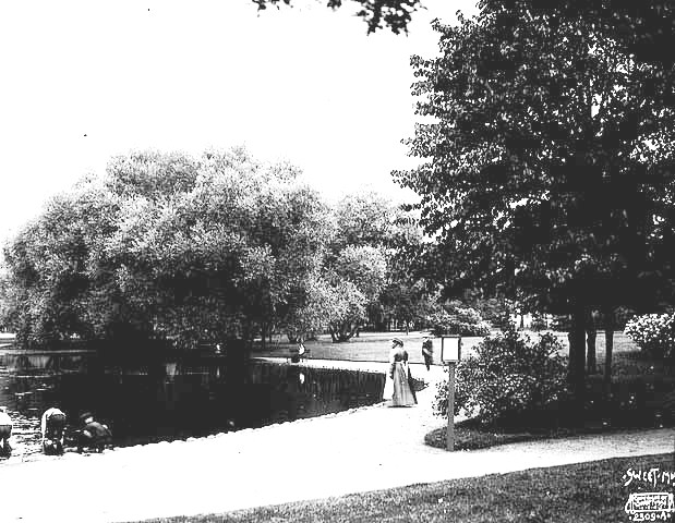
Van Cleve pond, 1905. (Sweet, Minnesota Historical Society)
The first playground equipment was installed in Van Cleve Park in 1907, following the huge popularity of the first playground equipment installed at Riverside and Logan parks in 1906.
The shelter was finally built in 1910, along with shelters at North Commons and Jackson Square. The Van Cleve shelter was designed by Minneapolis architect Cecil Bayless Chapman and was built at a total cost of just over $6,000. It included a boiler room, toilets and a large central room. The Van Cleve shelter was considerably more modest than the shelters at Jackson Square and North Commons, which cost approximately $12,000 and $16,000 respectively. On the other hand, neither of those parks had a pond. (Jackson Square actually had been a pond at one time, however, called Long John Pond. The cost of the Jackson Square shelter rose due to the need to drive pilings down 26 feet to get through the peat on which the park was built.)

The original recreation shelter at Van Cleve Park was built in 1910 facing the man-made pond. (Minneapolis Park and Recreation Board)
Wirth published a new plan for Van Cleve Park in the 1911 annual report. Although he claimed that Van Cleve demonstrated that a playground and show park could exist without “interfering” with each other, the playground occupied only a narrow strip of land between the pond and 14th Ave. SE. There were still no playing fields of any kind in the park then.
In 1917, Wirth recommended pouring a concrete bottom for the pond, really converting it into a shallow pool. Two years later the park board did pave the pond basin, but with tar macadam.

The Van Cleve shelter well after 1940 renovations, date unknown. (Minneapolis Park and Recreation Board)
Very few improvements were made at Van Cleve, or any other park in the city, for many years from the late-1920s to the late- 1940s. In 1935, in his last year as park superintendent, Wirth recommended that a swimming pool be built at Van Cleve in place of the pond, but the park board didn’t have the money for such a project during the Great Depression.
The park did get its share of WPA attention in 1940 when the federal work relief agency completed several renovations on the Van Cleve shelter to improve its capacity to host indoor recreation activities. Also included in those repairs were such basics as a concrete floor in the shelter’s boiler room. Comparing the two photos above, it’s obvious that the veranda was enclosed and the ground around the shelter was paved as well.
The man-made pond was finally filled in 1948. A modern, much smaller concrete wading pool was built to replace it the next year. The little rec shelter stood until a new community center was built at Van Cleve in 1970. By then Van Cleve, like most other neighborhood parks in the city, had been given over almost completely to active playgrounds and athletic fields.
Despite Cleveland’s aborted provision for a playground of some kind in his plan for Van Cleve Park in 1890, I imagine him astonished and a bit saddened to see neighborhood parks change so completely from the pastoral reserves and quiet gardens he had once preserved or coaxed from the urban landscapes of his time.
David C. Smith
© David C. Smith


Reblogged this on 3R_Redesign and commented:
Potential Site – Van Cleve Park // Bunge Tower
Good luck with your MFP.
You express surprise that East Sides in 1890 would prefer to have some water feature in this early park, rather than a ball field or other “play ground”:
“I find it odd that the park board would create a pond in a city full of lakes, streams and rivers, but more significant, and unexpected, is what the pond replaced in the plan. A playground.”
In fact, if one looks at maps of Minneapolis–either at the time or today–one is hard-pressed to see all those lakes and streams and rivers on the East Side. We have no lakes, no streams. Only the Mississippi, which for many East Siders is a good hike distant from where they live.
Our ponds and streams–I think particularly of Tuttle’s Brook that led to the lovely Silver Cascade waterfall on the University campus–were drained and filled in, rather than deepened, reshaped and enhanced, like, say, Lake of the Isles or Lake Nokomis, or the simply astonishingly massive work done to the lake and spring and surrounding topography in Loring Park. It was a series of decisions by Minneapolis (city and Park Board) that created such a disparity between the East Side and the rest of the city in terms of residents enjoying nearby lakes and streams.
It’s no surprise that in 1890 middle-class people like Prof. Folwell who lived in Southeast, or the Second Ward, wanted a water feature in their park.
Incidentally: the Van Cleve pond and its fountain (there are photos of it) was supplied by a freshwater well (it was dug up and closed off again only several years ago–just to the north of the current park building). That well was closed in the mid-1940s because the industry to the north and east of the Como neighborhood had so polluted the aquifier that Van Cleve’s fountain and pool water was both unpotable and dangerous. Especially for the children who splashed in it in summers.
I expressed no such “surprise” about what East Siders might want in their neighborhood park. And you’ve missed the point of my post entirely. What I find interesting is that a playground (not a “ball field”) was proposed for 2nd Ward Park long before playgrounds were a widely accepted use of park land. (And it would have been the first one in the city, too.)
But while we’re on your topic, why should it be up to the park board or city to provide for the East Side what God or Geology neglected? Of course there are no lakes in southeast Minneapolis. Should we complain that Colorado has the Rocky Mountains and Minnesota doesn’t. Did the National Park Service create that “disparity”?
I’m afraid that no amount of investment would have made Tuttle’s Brook into Lake of the Isles, Lake Nokomis or even Loring Pond. Should people who live along Lake Street ask the park board to move Tower Hill closer to them or make them one like it? It is more legitimate for them to ask why they have to travel so far to get to the University, which could have been located anywhere. Why does that have to be on the East Side instead of in the center of the city? That was a choice. The location of the lakes in Minneapolis was not.
The park board gave the East Side the first and nicest neighborhood parks and facilities. Notice that among the 1910 shelters — North Commons, Jackson Square, Van Cleve — none of them were within miles of the city’s lakes. Two on the East Side, one North. Logan Park had the only decent field house in the city for 50 years — and the park board also built a fountain there, its first (but not a pond).
In my opinion the park board’s job, executed remarkably well over 130 years, has been to maximize the city’s resources and create recreational oopportunity for every section of the city, not equalize its topographical features. The park board interpreted that responsibilty to mean that it provided a park, not a lake, within walking distance of every home in the city.
As for water supplies in Van Cleve, the park board considered extending water mains throughout the park in 1895 for watering purposes, so I don’t believe a well existed at that time. Theodore Wirth notes in his 1910 annual report that a well was drilled in Van Cleve Park that year. I can find no mention of an earlier well. But the presence of city water mains up to the park in 1895, and construction of toilets in the 1910 shelter, suggest that city water was readily available in the park. The well in the park was closed in 1940; it was due, the best I can tell, to bacterial contamination, not chemical. I’d have to look into that more to know the whole story. Regardless of the type of well contamination, it seems likely to me that the park was using city water for maintaining the pond. I would be surprised if the fountain in the pond couldn’t have used city water pressure. By that time many parks in the city had wading pools.
From 1909 to 1912 the park board drilled more than 50 wells in parks. Many of them were found to be contaminated within a few years and were closed. I’ll try to post more info on that soon.
I didn’t miss your point about playgrounds (although you really don’t give us any information about what a play ground would mean in Minneapolis of 1890; I see this post as speculating, until you locate Cleveland’s plans for Van Cleve, which I’m sure you will if they still exist).
I was simply pointing out that you made a statement about Minneapolis having so much water–river, streams, lakes–when the East Side of the city simply does not have what the Park Board created for the south side over several decades.
It is not that there were not marshes and bogs over here on the left bank of the river. God and geology (using your words) actually did provide water on the East Side that you seem not to be aware of.
Prospect Park sits on high, non-marshy ground, as does East Como (a glacial ridge). The original St. Anthony, right on the river, was deep sand. But as you go back from the river in the original topography, both in Northeast and Southeast, you get marshes, ponds, and streams of some importance. The pioneers regularly harvested cranberries from those extensive bogs with their large ponds that drained into the Mississippi.
The Como neighborhood, in fact, was a deep peaty marsh considered “unbuildable” for that reason by Minneapolis pioneers. The marshes and ponds on the East Side (Northeast and Southeast) were filled in, not dug out and enhanced as they were at, say, Loring Park, Lake of the Isles, Lake Calhoun, etc., in the early twentieth century. The lake that existed in the golf course at Columbia Park, for instance, was filled in with south side excavation dirt, but every good rain, according to Rep. Diane Loeffler and other Northeasters, that lake tries to return to fulfill its destiny, and golfers have to go around it. The same was true of the marshy ponds in NE and in the Como neighborhood, although the in-fill dirt in those instances didn’t come from Park Board projects. There were two quite large streams or brooks on the East Side, leading to stunning riverside waterfalls called the Silver Cascade and Fawn’s Leap, that residential and industrial development (not parks) closed off and filled in.
My point is: the south side constantly conflates itself and its water-based amenities with the entire city, which it is not. And Minneapolis only has water amenities, beside the river (far from us in Como and Prospect Park, actually, unless we’re on River Road), on the Right Bank, or West Bank side of the river. This disparity was the result of choices made in the past, as well as topography. It was not God that treated the East Side badly.
All I’m pointing out, from my own research, is that the original topography of Minneapolis’s East Side is not widely known and its real contours tend to contradict some of Minneapolis’s accepted history, especially of where the water was and what happened to it.
I appreciate the information you provide on east side topography. If the park board had been created ten or twenty years earlier than it was, some of the small streams and ponds east of the river might have been preserved. The same is true of Bassett’s Creek, as well as many small ponds in north and south Minneapolis. I have written about several of them on these pages. The park board was created partly because some far-sighted people saw the opportunities to prevent the disappearance of more places of natural beauty and interest and took action. As I pointed out in an earlier post, the difference between Bassett’s Creek and Minnehaha Creek was not that the park board decided to save one and not the other, but that one was already ruined in the heart of the city, surrounded by railroads and industry, and one was still unspoiled outside the city. One could be protected, the other couldn’t.
You give the impression, however, that Minneapolis’s lakes were simply engineered from ponds and marshes. They were not. The lakes existed on the earliest maps and were still there when the park board was created. No one ever said, “Let’s create a lake just aboooout …. here” and began digging. In fact, most lakes ended up smaller, not larger due to dredging. The reason for dredging at Lake of the Isles, Powderhorn Lake, Lake Nokomis, Lake Hiawatha and Lake Calhoun was to generate fill for marshy shorelines, not to create a lake where none existed. To paraphrase MaryLynn Pulscher, the park boards of the time — and Theodore Wirth — wanted land dry enough to drive on and water deep enough to sail on.
I disagree strongly with another claim you make: I have seen no evidence that the park board hauled muck from Lake of the Isles to fill Sandy Lake. Until someone can present even a decent theory of how and why that could have been done, I will continue to classify that as urban myth.
The park board had no reason to fill in a lake when it had worked so hard to preserve and acquire ownership of nearly every body of water in the city that was still viable. The park board’s record makes any accusations that it intentionally destroyed a lake for no reason rather dubious. Theodore Wirth built his reputation creating shorelines, not destroying them. When he thought Sandy Lake was no longer viable, I take him at his word that he recommended that the city storm sewers be constructed to drain the park.
Wirth in 1910 Annual Report: “The visitors to this park (Columbia) of 171 acres are increasing and the time has arrived when something should be done to make it more useful. Sandy Lake at the present time is absolutely dry and it will never be a satisfactory sheet of water except possibly in wet seasons. The flat formerly covered by the lake is 24 acres and it is possible to take care of the water through the sewers whenever they are extended within reach of the park.”
Wirth in Proceedings June 3, 1914: “Soundings recently made at Columbia Park on the large tract of swamp land formerly known as Sandy Lake, demonstrate that it will be impossible to improve that tract for any useful purpose unless some means are adopted to thoroughly drain it. If a small lake was constructed there through dredging the probabilities are that it would be partly drained as soon as the proposed sewer along 31st Street to the river is built. Therefore, the construction of a small lake is not desirable as it would be impossible to maintain it in the future…In order to assure the draining of these lands, which will be of great value to the park if drained, and almost useless if not, I wish to recommend at this time that the Board request that the Council have the proposed sewer on 31st Street so constructed that the grade of the bottom of same along or across the park be not higher than elevation 118 of city datum.” The proposal was referred to the Standing Committee on Improvements, which made its report on the matter to the full board the next month.
Proceedings, July 1, 1914: “Your Standing Committee on Improvements, to whom was referred the communication of the Superintendent in regard to the necessity for sewer connection to drain the low land in Columbia Park before it can be improved for a play field, respectfully reports and recommends that the City Council be requested to order a sewer constructed in such a way as to drain the low land in Columbia Park as soon as it is possible to do so.” (Now this is the interesting part.) “Respectfully submitted, P. C. Deming, A. A. McRae, Edward W. Hawley.”
Portius C. Deming was the longest serving park commissioner at the time with ten years of service. He was elected president of the park board the following January and served in that role for the next two years. Deming was a leading citizen from the east side of the river who had helped put together the original purchase of Columbia Park and was honored by having a park on St. Anthony Parkway, Deming Heights, named for him. Another committee member who put his name on that motion to the park board, Edward Hawley, was the Chair of the City Council’s Committee on Public Grounds and Buildings who served on the park board as an ex-officio member. At that time Hawley was serving his second of four terms as a City Council member representing the 2nd Ward. He was another powerful East Sider. While I have not studied either man’s political career, given the nature of politics at the time, I would guess that both were adept politicans and advocates for their neighborhoods. Not the sort of men to allow a lake to be stolen from under them.
If the public record isn’t persuasive, there’s more.
Filling Sandy Lake with dredge spoils from Lake of the Isles would have been the greatest logistical feat in park board history and you can bet Theodore Wirth would have explained how it was done in his book. Getting the ooze dredged from Lake of the Isles to stay on the shore of Lake of the Isles was so difficult that the first company hired to do the dredging quit and sacrificed its bond. How that liquid goop would have been hauled all the way through town in horse-drawn wagons I can’t imagine.
Especially when so much fill was needed so close to Lake of the Isles. Early park commissioners were a frugal bunch for the most part. I can’t conjure any rationale that would have had them paying to haul fill to Sandy Lake, then turning around and buying fill for Kenwood Park — right across the street from the lake — or for Bryant Square and a number of other closer locations. And they did buy that fill.
Finally, early park commissioners were opportunists, they acquired what they could get cheap. Or free. And so it was with shorelines. The majority of the early lakeshores and stream banks acquired by the park board was donated. Park land around Lake Harriet, Lake of the Isles, Minnehaha Creek — almost all donated. Lake Calhoun? More than half donated. (And the price paid for the rest of it was about half the price paid for Van Cleve Park alone.) For some reason, probably many, those kind of donations weren’t made by owners of property east of the river. I’m not aware that it ever was discussed, but I’d think there would have been a very good chance that if the University of Minnesota had offered the last remaining stretch of Tuttle’s Brook and its falls to the park board at no cost, it would have been accepted.
To my recollection the only land donations on the east side of the river were Stinson Boulevard by James Stinson and others, a portion of St. Anthony Boulevard by Armour (the golf course is more complicated), and Ridgway Parkway by the Chutes. None included shoreline.
Beyond this lengthy attempt to set a small part of the record straight, I want to add that I have lived in Prospect Park, Whittier, East Phillips and Linden Hills in Minneapolis, and Midway and Mounds Park in St. Paul. My parents lived in Northeast Minneapolis for several years. Never at any time have I considered the Minneapolis lakes to be the property of others, those who lived in south Minneapolis. I have always used the lakes and streams and river banks and waterless parks and have always been thankful to have them to use. They are a component in the quality of life I have always enjoyed here, wherever I lived.