A Bus Tour and a Road Trip
Thanks to everyone who joined the Preserve Minneapolis Waterfront Bus Tour on Saturday. It was a beautiful day. A few people asked for a map of the tour so here it is. Follow the (shaky) black line down from top left at The Parade.
Below is the turn-by-turn itinerary we followed as I talked about one of the greatest preservation feats in any city: maintaining public ownership of nearly every foot of waterfront in the city. By car it’s about a 90-minute drive without stops, but by bus it was nearly a half-hour longer owing to some tight turns and having to wait for cars and bicycles to clear some intersections before our excellent driver could navigate some corners. If anyone has any remaining questions raised by the tour, ask them as comments below and I’ll try to answer. I’d recommend this drive for anyone interested in seeing a broad cross section of waterfront and neighborhood parks in the southern half of the city. Perhaps in the future we will tour parks and parkways in north and northeast Minneapolis where there is not as much water but even more alluring neighborhood parks.
Bus Route for Waterfront Tour: August 17
Parade parking lot>
Spring Lake via right from parking lot onto Kenwood Parkway>
Lake of the Isles via Kenwood Parkway, left on Douglas, right on Logan, right on Franklin, left onto West Lake of the Isles Parkway>
Cedar Lake via West Lake of the Isles Parkway, right on Dean Parkway, right on Cedar Lake Parkway, left onto Sunset Blvd.>
Bde Maka Ska (Lake Calhoun) via Sunset Blvd, left onto Drew Avenue, left on Lake Street, right onto East Calhoun Parkway>
Lake Harriet via East Calhoun Parkway, left on William Berry Parkway and right on Lake Harriet Parkway>
Minnehaha Creek via Lake Harriet Parkway, right on West Minnehaha Parkway>
Diamond Lake (Pearl Lake) via West Minnehaha Parkway, to East Minnehaha Parkway, right on Portland Ave., right on E. Diamond Lake Road, right into Pearl Park parking lot>
Todd Park through parking lot, left on Hampshire Dr., left on E. Diamond Lake Road, right on Portland Ave. and left on E. 56th St., left on Chicago Ave. South>
Lake Nokomis via Chicago Ave. South, right on E. 54th St., left on W. Lake Nokomis Parkway, continue past beach>
Lake Hiawatha via W. Lake Nokomis Parkway, left on 22nd Ave. S, then right onto East Minnehaha Parkway>
Minnehaha Falls via East Minnehaha Parkway, right on S. Minnehaha Dr. at Godfrey Circle, left on S. Minnehaha Park Dr. to pavilion>
Mississippi River exit Pavilion parking lot, right on S. Minnehaha Dr., right on Godfrey Parkway, continue onto West River Parkway>
Seven Oaks Oval via W. River Parkway, left on E. 33rd St., left on Edmunds Blvd., right on E. 34th St., left on Park Terrace>
Longfellow Park via Park Terrace, continue onto 47th Ave. South, right on E. 35th St.>
Powderhorn Park via E. 35th St.>
Painter Park via E. 35th St., right on Lyndale>
Bryant Square Park via Lyndale Ave. South, left on E. 31st St.>
Lake of the Isles Lagoon via E. 31st St., right on Dupont, left at light on Lagoon, right on E. Lake Calhoun Parkway>
Lake of the Isles via East Lake Calhoun Parkway, right on The Mall, left on James Ave. So., right on East Lake of the Isles Parkway>
Thomas Lowry Park (Seven Pools) via East Lake of the Isles Parkway, right then immediate left on W. Franklin Ave., right on Oliver Ave. South., right on Douglas Ave.>
Parade Parking via Douglas Ave., left on Frontage Road, right on Groveland Terrace, left on Hennepin Ave., left on Vineland, continue on Bryant Ave. South to Parade parking lot.
A Longer Road Trip
I haven’t put in a plug for the Minnesota Historical Society for awhile so I thought it was time again.
A couple weeks ago we took a day adventure to visit the Jeffers Petroglyphs in southwestern Minnesota. It was a spectacular summer day with a cooling breeze. Driving through south central Minnesota is always a treat for me. It’s wonderful to get out of the city into farmland and prairie. As much as I enjoy the open sky from a lakeshore or riverbank in town, there is something more spectacular—practically intoxicating—about the vistas and the fresh air of farms and prairie. Most of the Minnesota prairie is cultivated of course, but the native prairie has been restored, regenerated, around the site of the petroglyphs between Comfrey and Jeffers.
We approached from the north because I wanted to visit Redwood Falls on the way, a town and a waterfall I had not seen in many years. I was surprised and pleased to see that signs in the Redwood Falls park were in both English and Dakota. (Those signs reminded me to ask that the Minneapolis park board provide at least English translations for the Dakota language cutouts in the metal sculptures at Bde Maka Ska.)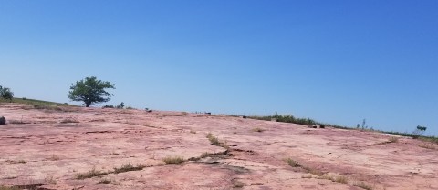
The 5,000 petroglyphs carved into a ridge of red rock—Sioux quartzite—emerging from the prairie tell of people long ago and hint at what they likely believed, enjoyed, feared and hoped. Some are thought to have been created 7,000 years ago.

A thunderbird image hammered into the rock with a harder rock. The thunderbird faces west, always west, our guide told us.
Of course, with my Minnesota Historical Society membership, there was no admission charge. Do yourself a favor and take the drive some day. The site is open every day but Tuesday. We had an excellent burger and a cheap beer at the Comfrey Bar and Grill for lunch, just a few miles from the petroglyphs.
Be sure to visit the rock outcropping rubbed shiny by itchy buffalo, too. Picture them in the thousands coming to the little spa for a good scratch. Most helpful were the labels that identified prairie grasses, plants and flowers on the trail from the visitors center to the petroglyphs. Now I know names for some of the (what I thought were) weeds in my yard! I was a great day to imagine a distant and quite different past, as well as to revisit a near and quite different present than we see in the city.
David Carpentier Smith


Thank you, Dave, for the most wonderful tour of the lakes on Saturday. It was so informative, but most particularly, it was so personable. I can tell that your love of our most remarkable park system is so evident. Will look forward to other talks that you will do in the future!! You touched the heart of an old parks employee!!
Cathy Maloney Bailey
We all owe a debt to you and thousands of others like you who have worked so diligently to preserve, defend and improve our parks, Cathy.
As the Park Board was created in 1883 and the city limits were expanded greatly in the 1880s, I’ve always been amazed that the entire shorelines and important adjacent lands of our lakes, rivers, and creeks as well as stand alone parks have been preserved during that crucial time of the growth and development of Minneapolis. We have a lot of public-spirited people to thank for this heritage!
The forward thinking of that generation was remarkable.