Archive for the ‘Minneapolis parks’ Category
Happy 99th, Don Johnson
Filed under: Minneapolis parks, Powderhorn Park, Winter Sports | Tags: Don Johnson, Powderhorn Park, Speedskating
 Comments (3)
 Don Johnson, a great, but little-known Minnesota athlete, just celebrated his 99th birthday. I hope you will join me in wishing him many more.
Don was a champion speed skater at the leading edge of a generation of speed skaters that dominated American speed skating from the 1930s into the 1950s. That was a time when speed skating races at Powderhorn Park and Como Lake in St. Paul drew tens of thousands of spectators and speed skating was an official sport in Minneapolis high schools. The sport thrived in part due to support from the Minneapolis Park Board and the excellent skating track it maintained at Powderhorn Park, but also due to sponsorship and hard work by several American Legion posts. Speed skating had similar support in St. Paul.

Don Johnson winning the 440-yard national championship in 1947, narrowly defeating his long-time rivals Ken Bartholomew on the right and another Minneapolitan, Bob Fitzgerald, on the left who tied for the silver medal at 500 meters in the 1948 Winter Olympics. At that time in the U.S. speed skaters raced in a pack, instead of racing against the clock as was done in the rest of the world. Pack-style racing was considered more entertaining for fans and resulted in much more strategic races. (Photo courtesy of Don Johnson.)
For another view of Don winning a race, check out this newsreel Clip of him winning the 880 in the 1948 national championships. (His is the second race in the newsreel.)
The first Minnesota skaters to break onto the national scene in that era and win national titles were James Webster of St. Paul, then Marvin Swanson of Minneapolis in the mid-1930s. They were followed by Johnson and Dick Beard, high school teammates at Minneapolis Central, then in rapid succession by Charles Leighton, future Olympic medalists Ken Bartholomew and Bob Fitzgerald, John Werket, Art Seaman, Pat McNamara, Gene Sandvig, Floyd Bedbury, and Tom Gray. All were national or world champions or Olympians. Women enjoyed a run of success nearly as impressive, led by Dorothy Franey, Mary Dolan, and Louise Herou of Minneapolis and Geraldine Scott, Janet Christopherson, Gwendolyn DuBois and Diane White of St. Paul, all of whom won national championships. (Women’s speed skating was an exhibition event at the 1932 Olympics in Lake Placid and Dorothy Franey of Minneapolis was on the team. Women didn’t compete in speed skating again in the Olympics until 1960. Mary Lawler of Minneapolis made the 1964 team.) Many more Minneapolis skaters excelled — won national championships or set age group records — at junior and intermediate levels. Of course there have been many world-class speed skaters from Minnesota since the early 1960s as well, but by then the Twin Cities, especially Powderhorn Park, was no longer the center of the American speed skating world.
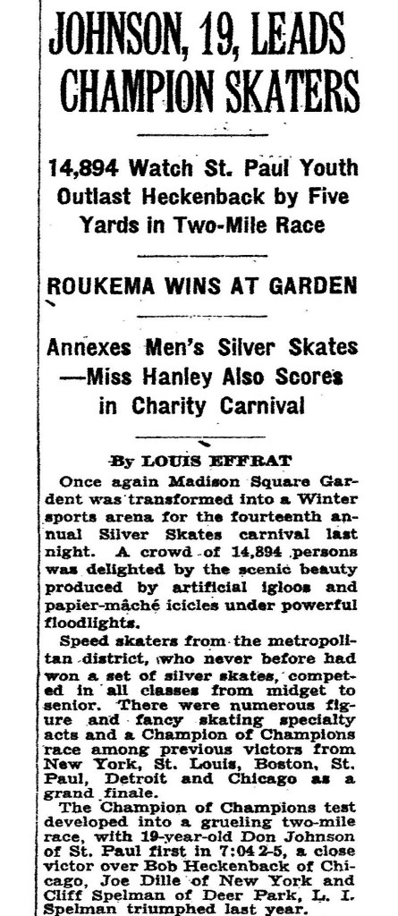
This article from the New York Times, February 8, 1938 tells the story of Johnson’s victory. The rest of the article covers the other races held that night.
One of Don Johnson’s greatest triumphs was as a 19-year-old at Madison Square Garden where he won the Champion of Champions two-mile race at the Silver Skates tournament before a crowd of nearly 15,000 in 1938.
Johnson recalled that the celebrity starter for the race was former heavyweight boxing champ Jack Dempsey.
What makes Johnson’s victory particularly impressive was that he enjoyed some of his greatest successes at shorter distances such as the 440 and 880 highlighted above — and on longer outdoor tracks. If you’re a sports fan you know that Madison Square Garden is the most famous basketball arena in the world, meaning hardly large enough for a speed skating rink. The track was about the size of the hockey rink when the New York Rangers played in the famous arena. The track hardly had a straightaway. At 16 laps to the mile it was all corners. If there was a precursor to today’s short-track speed skating, MSG was it.
Two Weeks Pay
Johnson almost didn’t make it to New York for that meet. Right out of high school, he had gone to work for General Electric in Minneapolis. He couldn’t afford to miss two weeks of work to make the trip to first Michigan for the national championships and then to New York for the Silver Skates meet. The St. Paul newspaper that sponsored the race locally — he qualified by winning the race in St. Paul — agreed to pick up his pay for the two weeks he would be gone. (The outdoor nationals in Petoskey, Mich. were cancelled due to warm weather and rain showers.)
Johnson returned to MSG the next year, 1939, to defend his title along with his local rival Ken Bartholomew. As the New York Times reported on February 7, 1939 the two were among ten of the leading speed skaters in the country that took part in the event. The race had another capacity crowd in the Garden on their feet at the finish. The grueling race ended in what the Times called a “blanket finish” by the top four skaters. The judges deliberated for five minutes while the crowd awaited an announcement of the winner. The Times reported that spectators thought the delay was due to debate over whether Johnson or Vincent Bozich of Detroit had won or whether it was a dead heat. Ken Bartholomew had finished a hair behind them. The judges’ decision shocked everyone: Johnson, Bozich and Bartholomew were disqualified for “pushing on the turn.” The victory went to the fourth place finisher who represented New York in the race. Such was life in the rough-and-tumble world of pack-style racing — where “pushing” was part of racing.
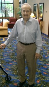
Don Johnson when he was only 96.
Despite Johnson’s successes, he was not selected for the 1940 Olympic team. Neither was Bartholomew. The only Minnesota skater to make that team was Charles Leighton. Of course he never got to race in the Olympics due to WWII. By the time the Olympics resumed in 1948, although still highly competitive with the country’s best — as witnessed by the photo and clip above — Johnson did not compete in the St. Moritz Olympics, but attended the Games as an alternate.
Two of Don’s long-time competitors from Minneapolis, Ken Bartholomew, who married Don’s sister, and Bob Fitzgerald, who was an altar boy at Don’s wedding, tied for the silver medal in St. Moritz in the 500 meter race, the only Americans to win speed skating medals in those games. They proved that Americans could win medals even when they skated the less exciting European Olympic style. No pushing.
Happy Birthday, Don. We hope we’ve helped revive happy memories of good friendships with tough competitors.
David C. Smith
Help a Neighborhood Help a Park: Elwell Park III
Filed under: Minneapolis parks | Tags: Elwell Park, Marcy-Holmes Neighborhood Association, Turtle Park, Wilson Park
Comments (5) The first Elwell Park in southeast Minneapolis was traded to a manufacturing company in 1952. The second Elwell Park was obliterated by a new freeway in 1962. Now the third Elwell Park needs your help. It’s not being wiped off the map like its older siblings, but it could use some TLC. The Marcy-Holmes Neighborhood Association is raising money to refurbish the tiny park called a “totlot”. Anyone can contribute to this unusual little park at givemn.org, where you can also learn more about the project.

Elwell Park is often called “Turtle Park” for the mosaic reptile that is its distinguishing feature. Your contribution will help restore the mosaic tiles on the turtle shell as well as a nearby “couch.” Artist Susan Warner, who created the originals, will do the repair work. Contributions will also help refurbish the park’s metal sculptures by Marcia MacEachron and replant flowers.
Elwell Park III, located at 714 Sixth Street SE, was established in 1968 after I-35W ran over Elwell Park II and cut off the neighborhood from Van Cleve Park to the east. The park serves one of the city’s oldest residential districts, which filled in between the original town of St. Anthony at the falls and the University of Minnesota.

The dedication of the first Elwell Field in 1940. It was located at the industrial northern edge of the Marcy-Holmes neighborhood. The neighborhood draws its name from the two elementary schools that originally served the neighborhood. Two parks in the neighborhood also took their names from the schools.
You can read more about the first two Elwell Park’s in my description of Minneapolis’s “Lost Parks.”
Several Minneapolis parks lost land to the construction of freeways in the 1960s, but only two were completely wiped out: Elwell Park II and Wilson Park, which was blocking the path of I-94 ramps into and out of downtown Minneapolis north of the Basilica. (Read more about Wilson Park and other park losses to freeways here.)
The next nice weekend, ride your bike or walk to Elwell “Turtle” Park to get a feel for what you can help accomplish with a donation of a few bucks.
David C. Smith
After I posted the above I remembered a photo that people in Marcy-Holmes especially might enjoy.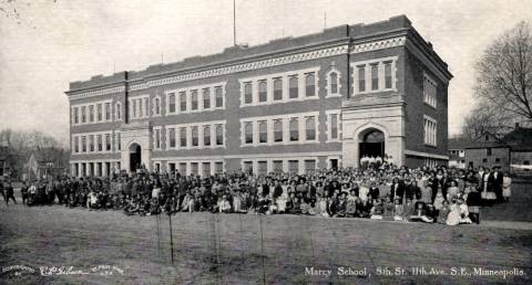 This is a C.P. Gibson photo on a postcard of the second Marcy School at 8th St. and 11th Ave. S.E. The school opened in 1908 and this photo was probably taken around that time. This school building no longer exists, but the property is now Marcy Park. The park board wanted to convert the first Marcy School property at 4th St. and 9th Ave. S.E. into a park around 1910, but property owners in the neighborhood didn’t want to pay assessments to create a park so the property continued as a school, renamed Trudeau School, until 1938. The park board eventually took over the original Marcy School site in 1952 and created a park there named Elwell Park. That was Elwell Park II — which now lies beneath I-35W.
If you want more help in sorting out the many schools that have existed in the Marcy-Holmes neighborhood, many that had redundant names, visit the school inventory page at electiontrendsproject.org, still one of the most useful resources for Minneapolis historians.
Behind the Scenes: Minneapolis’s First Park?
Filed under: Minneapolis parks | Tags: H.W.S. Cleveland, Horace Cleveland, Lakewood Cemetery
Comments (3) You have a rare opportunity in April to tour the greenhouses in one of the first parks in Minneapolis: Lakewood Cemetery.
Technically, the first park in Minneapolis was Murphy Square, which Capt. Edward Murphy donated to the city as a park in 1857, but Murphy Square was used as a pasture for nearly two decades.
Lakewood Cemetery was created in 1871 — 12 years before the Minneapolis Board of Park Commissioners was created — by many of the same people who helped create the Minneapolis park system. Names such as Loring, Brackett, Morrison and King are as much a part of cemetery history as they are of park history. Lakewood Cemetery even donated some of the land that is now the Thomas Sadler Roberts Bird sanctuary on the north shore of Lake Harriet to the park board. Once when the park board was short of cash, it borrowed money from the cemetery.
H.W.S. Cleveland and Lakewood Cemetery
Another name that links Lakewood Cemetery with Minneapolis parks is Cleveland — but not in the way that many assume. Horace William Shaler Cleveland, whose blueprint guided the development of Minneapolis and St. Paul parks, did not design Lakewood Cemetery, although he designed many cemeteries across the country. In 1884, the cemetery’s trustees hired Ralph Cleveland, Horace Cleveland’s son, as superintendent. The fact that Ralph had no prior experience in such a position and the trustees consisted largely of men who had worked closely with Horace Cleveland in creating the Minneapolis park system suggests that Ralph’s hire may have been a favor to the father. That became a larger issue in the future of Minneapolis parks in 1886 when Horace and Maryann Cleveland moved from Chicago to Minneapolis, in part to be nearer Ralph and his family.
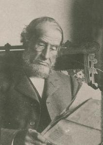
H. W. S. Cleveland
They had good reasons. Horace was 72 at that time and looking to the day when he could no longer perform the often strenuous physical duties of a landscape architect. He was also raising his two young granddaughters, whose father, Horace’s oldest son, Henry, had died of disease in the jungles of Colombia in 1880. And he couldn’t count on help from his wife, Maryann, who was frail and ill much of her adult life. Living near their only surviving child made sense.
I don’t think the St. Paul and Minneapolis park systems would be what they are today if Horace Cleveland had not moved to Minneapolis when he did. He became a strong presence in park debates. The opinions of Professor Cleveland, as he was called, were often quoted in the newspapers, which would have been far less likely if he had remained at the distance of Chicago. Would Minneapolis have acquired Minnehaha Falls without Cleveland’s prodding? Would St. Paul and Minneapolis have acquired the Mississippi River Gorge on both sides of the river without his constant encouragement and dire warnings? Would park commissioners have continued to heed Cleveland’s advice to forego improvements and decorations in the parks in order to buy more land if Cleveland hadn’t been looking over their shoulders? I suspect the answer to one or all of those questions is “No!”
I think a case could be made that Lakewood Cemetery, by hiring Ralph Cleveland as superintendent in 1884, is indirectly responsible for much of the success of the park systems in St. Paul and Minneapolis.
You’re Invited!
From its inception, Lakewood followed the national trend of creating “garden” cemeteries that were designed to be picturesque parks as well as cemeteries. An integral part of the operations of those cemeteries was growing their own flowers and decorative plants in greenhouses. The flowers were planted to beautify the cemetery grounds and were sold for placement on graves.
Lakewood Cemetery retains one of the largest cemetery greenhouse operations in the country raising 95,000 plants annually in two greenhouses. And it is inviting you to take a closer look and learn more about this colorful part of its history at a time when its greenhouses will be at their showiest!
Lakewood Cemetery will conduct tours of its two greenhouses on Earth Day, April 22 from 10 a.m. to 1 p.m. There is much more information at lakewoodcemetery.com. You’ll even get to pot a plant to take home!
I encourage you to check out the website, but don’t wait too long. The tours have a limited capacity, so reservations are required. The tour is open to all ages and it’s free, with an optional donation of $5 suggested.
Whether you’re a gardener or a history buff, it sounds like a great opportunity to see something that’s usually out of sight. Spend a couple hours in the morning helping clean up your favorite park — or join the Minneapolis Parks Foundation or Friends of the Mississippi River in their cleanup efforts — and then dash over to Lakewood Cemetery.
While you’re there, pay your respects at the graves of Horace, Maryann and Ralph Cleveland.
David C. Smith
© 2017 David C. Smith
Defining Wirth
Filed under: Minneapolis Park Board, Minneapolis parks | Tags: Charles M. Loring, Hennepin County Library, Lyndale Farmstead, Phelps Park, Theodore Wirth
Comments (5) The Minneapolis Park Board and Hennepin County Library report that we are probably only weeks away from the transfer of the park board’s historical archives to the downtown Minneapolis library. A valuable trove of historical information will be preserved, protected and made available to the public as never before.

Theodore Wirth outside the house built by the park board at Lyndale Farmstead in 1910. This 1927 Christmas card was found in the park board files moved from the City Hall clock tower to park board headquarters to prepare them for their imminent transfer to the Hennepin County Library. (Minneapolis Park and Recreation Board.)
Among the more intriguing documents discovered in preparing those archives for transfer to a better place was a letter from Theodore Wirth to Charles Loring, July 4, 1905, after Wirth visited Minneapolis to consider taking the position of Superintendent of Parks. Upon returning to his home in Hartford, Connecticut, where he held a similar position, Wirth wrote to thank Loring for his hospitality and, more importantly, to outline his terms for accepting the position in Minneapolis.
The letter was an exciting discovery because for many years I and others have looked for evidence that Loring and the park board had agreed in 1905 to build a house for Wirth. That house was eventually built in 1910, four years after Wirth came to Minneapolis, at Lyndale Farmstead on Bryant Avenue near Lake Harriet. Theodore Wirth lived in the house until 1945, ten years after he retired as park superintendent. It was occupied by succeeding superintendents from then until David Fisher moved out of the house to one of his own choosing in the mid-1990s. The house became the residence of the superintendent once again in 2010, however, when Jayne Miller chose to live there when she moved to Minneapolis.
The construction of a house on park property for Wirth was very controversial in 1910. The park board’s authority to build it was challenged in court. The park board justified its decision in part by claiming that the structure was not just a residence, but an administration building—and also claimed that the house fulfilled a condition of Wirth’s employment years earlier.
Although park board plans to build the house as a residence for Wirth survived a court challenge—by a split vote in the Minnesota Supreme Court—historians, including me, had found no proof that the park board had agreed to provide housing for Wirth. I had seen a copy of Wirth’s five-page letter from 1905 proposing the terms of his employment, but the pertinent portions of that copy were utterly illegible. Now, we can read them in Wirth’s original ink.

In his July 4, 1905 letter Wirth wrote that among his conditions for accepting the park superintendent’s job in Minneapolis, “I would expect that as soon as circumstances permit I be furnished a house and privileges similar to what I am having now.” As superintendent of parks in Hartford, Connecticut, Wirth and his family lived on the second floor of a large house that stood on land donated as a park to Hartford. The ground floor of that house served as a concession stand and visitors center. (Minneapolis Park and Recreation Board)
In a subsequent letter to Loring, Wirth wrote that while he was torn between staying in Hartford or moving to Minneapolis, he had stated his terms for accepting the Minneapolis job and the park board had agreed to them, so he felt honor-bound to accept the new job. That is as close as we can get, without seeing Loring’s actual response to Wirth, to knowing that Loring and the park board had agreed to meet Wirth’s expectation of a house.
Why had the original letter been missing for so long? We found it in a file of park board correspondence not from 1905, but 1911! No one ever would have looked for it there. I suspect it was filed there after the court case had been decided and the supporting documents were no longer needed and were thrown into a current file. It probably hadn’t been looked at between 1911 and last summer.
Proper Attribution: A Park within a Half-mile of Every Residence?
Another discovery of interest to me in the documents soon to take up permanent residence at the library was a memorandum from Wirth that sheds light on the often-repeated claim that he championed a playground within a half-mile of every residence in the city.
The attribution of that claim to Wirth often presumes that he not only supported it but that it originated with him. I have scoured Wirth’s writing and the park board’s published records for the source of that particular measure for playground location. No luck. I couldn’t find that standard proposed by Wirth even in the hundreds of pages he wrote for his annual reports.
The only similar claim I was able to find was in the autobiography of Wirth’s son Conrad, who was the director of the National Park Service 1951-1964. In Parks, Politics and the People, published in 1980, more than 30 years after his father’s death, Conrad associated the “park within a half mile” concept with his father.
Then came the deep dive into once dusty archive boxes. A 1916 committee file contained many petitions signed by residents of south Minneapolis asking for a park at 39th and Chicago — what eventually became Phelps Field. Theodore Wirth submitted his opinion to a joint committee considering the issue. He opposed the playground because it was within the district already served by Nicollet (Martin Luther King) Field and Powderhorn Park. He explained,
“It is conceded by playground authorities from all parts of the country that one good-sized playground per square mile of city area is sufficient for even densely populated districts.”
That hardly seems the statement of a man who had created the standard. While I have not researched the subject on a national scale to see where the standard did originate, it appears that the park per square mile standard was already widely used. Keep in mind that Minneapolis was fairly late to the practice of establishing playgrounds under the auspices of a park board, so it was an unlikely pioneer in developing standards for playground locations. To the credit of Minneapolis and Theodore Wirth, however, Minneapolis probably came closer to meeting that standard eventually than almost all other cities.
By the way, the park board did not take Wirth’s advice in this instance and approved the acquisition of Phelps Field despite its proximity to other playgrounds and the large amount of grading that Wirth asserted would be required to make the land into usable playground space.
Hundreds more documents, like these, that provide information and insights into the creation and evolution of Minneapolis’s parks will soon be available to everyone at the library.
Congratulations!
The transfer of the park board archives culminates the work of several years. Park commissioners, led by Scott Vreeland, superintendent Jayne Miller, and park board staff, especially Dawn Sommers and former real estate attorney Renay Leone, deserve thanks for their commitment to preserving park historical records. The project also owes a great deal to the cooperation of Josh Schaffer in the City Clerk’s office, and Ted Hathaway, director of Special Collections at Hennepin County Library.
I would encourage local historians, especially those with an interest in the first half of the 20th Century, as well as park enthusiasts, to take a look at the archives once Ted and his staff at the library can make them available. They provide a fascinating historical view of not just a park system, but a city.
David C. Smith
Norma Olson Remembers Prospect Park Triangles
Filed under: Minneapolis parks | Tags: Maris Thomes, Norma Olson, Pratt School, Prospect Park, Tower Hill
Comments (5) In Devon, England last week a former resident of Minneapolis found this website and was intrigued by my account a few years ago of the smallest parks in Minneapolis, the triangles in Prospect Park, near Tower Hill. Becky Stannard, my correspondent, remembered them well, having attended Pratt School. But she had more than memories, she had a story about how the boulders appeared on the triangles there. It was written by her mother, Norma Olson. I have printed it below, with thanks to Becky and Norma.
Maris’s Mini Parks
By Norma Olson, 2-28-94
In Prospect Park
Where we lived for 40 years
Scattered through the neighborhood
At the intersections of streets
Are small triangles and squares of land
Left over from the making of streets
Whose design was influenced
By the old cow paths
Dating back to farming days.
When Lady Bird declared
With enthusiasm, if not passion
That Beauty was important
That wherever possible, in America
We plant a shrub or tree
We took it to heart.
The local Beauty Committee
Especially Maris Thomes
Who has lived some in Japan
Started talking about the opportunity
Offered by our bits and pieces — the triangles.
She cocked her head and mused
Wouldn’t it be nice
If we had some big rocks
To help us dress up those triangles?
For some months, after finding myself
President of the Minneapolis Committee on Urban Environment
An organization with big ideas, little power and no budget
I had been visiting around City Hall
With the pros at the Park Board, the Housing Authority and Public Works
It’s sort of a treat for middle management bureaucrats
To dream a little and to visit with neighborhood people
Who aren’t asking for anything.
While I knew most of these folks from other contexts
They might have eyed me with
A certain amusement
But a condition of trust existed.
On this day, in late winter I dropped in on Martin,
Associate Operations Engineer
At Public Works, during his coffee break.
“Well, come in and sit a spell. What are you up to today, Norma?”
“Nothing much.”
“Don’t tell me you don’t have a project up your sleeve.”
“Well, there is Maris’ dream.”
“Heavens, what’s that?”
“Well, you know all those triangles in our neighborhood
That you folks long ago left behind
When you designed the streets.
They look bad but they could be a visual asset.”
“How so?”
“We have in mind that we’d like to do
Something with them.
Like clean them up, do some planting.
Maris says we need some big rocks
To add a sculptural quality.
Remember, Martin, you asked me and I thank you.
So thanks for listening.
But as you can see, I’m not setting
The world on fire.”
One evening in early fall, the phone rang at 10 P.M.
“Hello, Norma, this is your friend
Martin from Public Works.
You know, we are excavating
For those huge storm sewers all over S.E.
And you can’t believe the big rocks we are encountering
I mean two or three tons.
Could you use some?
“Oh, yes!”
“How many”
“Twenty-seven. Three for each of the nine street triangles
We talked about earlier.
But we’ve got no trucks, no transport, no manpower, no budget.”
“Well, no problem,” says Martin.
“If you will wait until the ground freezes
So we don’t break the curbs driving over them
And if you will let me know
Exactly where you want them
I will deliver them to you in the evening
And give you warning when they are coming.”
Agreed.
Maris responded to this offer with wild enthusiasm.
And with three weeks of lead-time!
Preparing plans would be easy. Agreed.
Being an artist, it was not difficult for her to take
Measurements of the nine sites.
And in consultation with resident architects
She mapped each triangle xxxing in the rock locations
Respecting that some would be more round or oblong
Than others.
Then came the phone call.
Meet Martin at the Franklin Hill triangle at 8 P.M. tomorrow night.
Before midnight, under Maris’ directions
All 27 rocks were in place
In dynamic groupings of three.
In the morning, neighbors looked out on a new landscape.
Well, not everyone was enchanted.
Bill called to say, “Do you know that one neighbor is hopping mad
To find those big rocks on her triangle.”
But the unfriendly soil was worked
Tulips bought with memorial money were planted
A few shrubs went in
And we sat back to wait for spring.
Propriety residents from the immediate rock locations
Joined the work crews
And soon the neighborhood had a new visual identity
The triangles had become a unifying factor in the
Neighborhood design.
Then came the day
When the street repaving crews showed ready and raring to tear up
Existing curbs and streets. Panics. The phone rang off the hook.
We went immediately to see
Perry, the chief of Public Works and told him our story
And insisted that the triangles had to be respected as follows:
Leave the rocks in place or replace them precisely if the have to be moved.
Let the new landscape designs for the neighborhood include the triangles.
Assign a budget number for new materials
As compensation for time and plant materials expended.
These requests were in written form
We were accompanied on this mission by the
Administrative Assistant of our Alderman.
Perry was impressed that the requests were reasonable
Agreement was reached. The neighborhood was reassured.
And so the newly curbed triangles, after consulting, were
Expertly planted with many new evergreens as a base
Were ready for spring materials.
And so they have become a vital part of
The Neighborhood landscape
With adjacent owners feeling possessive
Looking after maintenance.
Mandy managed her triangles.
Kate planted a tree for John Berryman
The Franklin Avenue Bridgehead Planting included a Ginkgo Tree.
It was a project of enormous satisfaction to me
Because it cost so little, brought staff and citizens
Into an effective working relationship
And strengthened the neighborhood
With another point of pride. It was fun making it happen.
Thanks also to Maris Thomes, Martin, Perry, Bill, Kate, Mandy and everyone else who took part in this successful collaboration.
While on the subject of Prospect Park and Tower Hill, I have a question. Does anyone know the inside story on what happened to plans to vacate Malcolm Ave. S.E. between Pratt School and Tower Hill Park? I recently came across park board resolutions and drawings of plans to vacate the street and turn it into a playground for the school. The original plans were dated 1928, but the issue was raised again in 1950 in response to petitions from the neighborhood and another resolution was approved to complete those plans. The park board announced in the 1950 annual report that the vacation of Malcolm Ave. had added 0.17 acres to Tower Hill Park. But Malcolm Ave. still runs between the school and park. Was it closed, then reopened? I’m sure someone knows the story. Please share.
David C. Smith
Minnesota River Valley National Park?
Filed under: Minneapolis parks | Tags: Friends of the Mississippi River, Harold W. Lathrop, Minnesota River, Mississippi National River and Recreation Area, National Park Service, Theodore Wirth
Comments (2) What does the Minnesota River have to do with Minneapolis parks? The Minneapolis Board of Park Commissioners, in 1934, tried to help Minnesota Gov. Floyd B. Olson convince the federal government to acquire the Minnesota River valley from Shakopee to Mendota and make it a national park.
I only have the bare bones of the story, but I wanted to throw them out there so someone else could expand it if so inclined. I find this bit of history particularly interesting in light of important efforts by Friends of the Mississippi River and the National Park Service to protect and preserve our rivers. In 1934, Gov. Olson wrote to the Minneapolis park board asking for assistance. I’ve reproduced the letter in full.
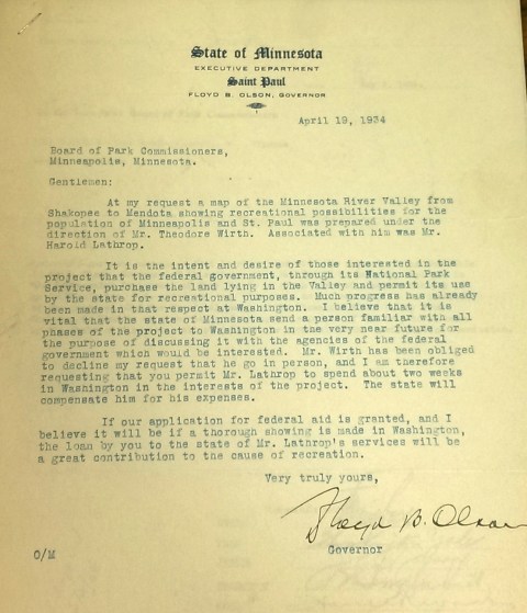
Gov. Floyd B. Olson asked the Minneapolis park board for help in creating a national park of the Minnesota River Valley in April 1934.
Always willing to cooperate on park projects, the Minneapolis park board, with Supt. Theodore Wirth’s support, voted on May 2 to give Harold Lathrop, “an employee in the Engineering Department,” leave of absence with pay to go to Washington, D.C. “and spend such time as is necessary in the interest of the proposed plan.”
It’s obvious from Gov. Olson’s letter that he had already secured the assistance of Wirth and Lathrop, and the park board presumably, in creating a map of the “recreational possibilities” of the area. I have never seen such a map created solely for that purpose, but in 1935, the park board published Theodore Wirth’s Tentative Study Plan for the West Section of a Metropolitan Park System. That report contained a detailed map of all of Hennepin County and more, including the closeup below of the Minnesota River Valley. (The full report and map are appended to the park board’s 1935 annual report.)

Detail of park possibilities in the Minnesota River Valley, Shakopee to Mendota, from a 1935 study plan by Theodore Wirth. Harold Lathrop, a park board employee in the engineering department, assisted Wirth on the report. (Minneapolis Park and Recreation Board.)
I don’t know what became of Gov. Olson’s idea of a national park when Lathrop went off to Washington, D.C. An update came a month later when, at its June 6 meeting, the park board approved Wirth’s recommendation that Lathrop be given two months leave of absence without pay “to act as Project Director for the Federal Government in connection with the proposed Minnesota River Valley development.”
Barbara Sommer writes in Hard Work and A Good Deal that Lathrop was then hired by the National Park Service, which ran the Civilian Conservation Corps (CCC), a federal work-relief program, to supervise CCC work in state parks in Minnesota. There is no indication that any of that work involved a potential park along the Minnesota River. The young National Park Service employee running the CCC program was Conrad Wirth, Theodore’s middle son. Conrad’s performance in that role set him on a trajectory to become the Director of the National Park Service in the 1960s.
I don’t believe Lathrop ever returned to the Minneapolis park board. From his job coordinating federal work in state parks, he was hired as the first director of Minnesota State Parks less than a year later in July 1935. He held Minnesota’s top state parks job until 1946, when he supposedly retired at age 45. Eleven years later, however, he became the first director of state parks in Colorado. Colorado’s first state park is named Lathrop Park.
That’s all I know of the proposed Minnesota River Valley National Park—an intrigue sparked by one letter from the governor in a correspondence file. If you know more, I’d be happy to hear from you.
David C. Smith
P.S. Timely! Friends of the Mississippi River is hosting a fundraiser tomorrow night — October 4—at the Nicollet Island Pavilion in Minneapolis. Suggested donation $100. Worthy cause! Also read the current StarTribune series on threats to the health of the Mississippi.
Burma-Shave, Clinton O’Dell and Minneapolis Parks
Filed under: Minneapolis parks | Tags: Clinton O'Dell Burma-Shave, Eloise Butler, Eloise Butler Wildflower Garden Friends of the Wild Flower Garden, Friends of the Wild Flower Garden, Painter Park
Comments (7) Thanks to Lindsey Geyer for sending this picture of Painter Park last week.
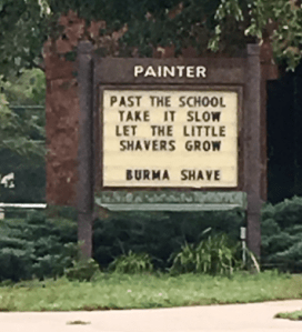
The sign at Painter Park, 34th and Lyndale, on September 30, quotes a famous Burma-Shave sign.
Lindsey is probably one of the few people who know the deeper connection between Burma-Shave and Minneapolis parks, especially the Eloise Butler Wildflower Garden in Theodore Wirth Park.
Burma-Shave was an invention of a Minneapolis company, Burma-Vita. It was a shaving cream that didn’t require a brush to whip it into a lather and apply. You just rubbed it on with your fingertips. The company president was Clinton O’Dell. He and his sons were looking for a way to market their invention and hit upon the idea of creating signs to post along highways. They painted their advertising on a series of signs and placed them 100 feet apart, a nice distance to read comfortably for people in cars travelling at the dizzying speed of 35 mph.
The O’Dells painted the signs and dug the post holes for them along highways after getting permission from landowners. This was in 1925. The first signs were placed on highways from Minneapolis to Albert Lea and St. Paul to Red Wing. Sales boomed. The signs spread.
In 1940, letterhead of the Burma-Vita Company featured a faint map with a red dot to show the location of every set of Burma-Shave signs the company had placed.

Every dot is a set of Burma-Shave signs in early 1940s, long before interstate freeways. It appears that only five states did not have any Burma-Shave signs. (Enlarged by Lindsey Geyer from Burma-Vita Company letterhead from a letter dated May 6, 1940 to the Minneapolis park board. Minneapolis Park and Recreation Board.)
Sales of Burma-Shave peaked more than a decade later when there were 35,000 Burma-Shave signs. (I haven’t tried to count these dots, but it looks to be considerably shy of 35,000.) They were still being placed along highways into the 1960s, but by then interstate highways and much faster speeds had made the landmark signs a less effective marketing ploy. (Lady Bird Johnson’s Highway Beautification program in the mid-1960s restricted advertising along for federal highways, which had a large impact, too.) The Burma-Shave signs were, however, still a highlight of cross-country car travel in the 1960s. When my family travelled, everyone was roused from whatever they were doing as soon as anyone spotted the first red sign in the distance.

Silly jingles, mostly touting the benefits — often romantic — of a clean shave, were always followed by the Burma-Shave logo. For a catalog of the jingles visit burma-shave.org.
So what does this have to do with Minneapolis parks? When Clinton O’Dell attended Minneapolis Central High School in the 1890s he had a botany teacher named Eloise Butler. Ms.Butler went on to fame as the creator and tender of a fabulous wildflower garden in a portion of what was then Glenwood Park, later renamed Theodore Wirth Park. First as a successful insurance man and later as the owner of Burma-Vita, O’Dell was a significant contributor to the wildflower garden Butler created. For many years he donated money for work in the garden, but in 1944 he donated $3,000 to expand the garden beyond the woodland garden it originally was. An upland or prairie section was added thanks to O’Dell’s generosity. Several years later, in 1951, O’Dell was one of the founders of the Friends of the Wild Flower Garden, an organization that has been critical to the continued success of the garden for more than 60 years. (More info on Friends of the Wild Flower Garden and Clinton O’Dell.)
Thanks to his Burma-Shave fame, O’Dell was named to the Minnesota 150: The People, Places, and Things that Shape Our State, by Kate Roberts, a book by the Minnesota Historical Society Press and an exhibit at the historical society in 2007.
Bottom line: Those catchy Burma-Shave jingles and the ubiquitous red roadside signs were partly responsible for one of the most venerated and beloved patches of Minneapolis park land.
And “Past the school take it slow. Let the little shavers grow” is pretty good advice at any time—even though it had been replaced on the Painter Park sign by Saturday, October 1. In its place was news of a new Zumba class. Fitness is good, too!
David C. Smith
More Lake Nokomis Bath House
Filed under: Minneapolis Lakes, Minneapolis parks | Tags: Lake Nokomis Bath House
Comments (4) In an enjoyable article on Lake Nokomis in MinnPost, Andy Sturdevant provided a link to a couple photos I posted last month of the Nokomis Bath house, so I thought I’d return the favor. I’ve been intending to post this new photo of the bath house I found on a 1920s postcard, so Andy’s article provides a good excuse. I had not seen this photo until a few weeks ago.

Lake Nokomis Bath House in the 1920s. Photographer unknown.
Anyone who knows old cars might be able to date this photo more precisely than I have. Anybody know their early autos? Let us know a likely date range. Based on the age of the trees I would guess it must be very early 1920s.
You can make out the Cedar Avenue bridge in the background. Theodore Wirth wanted to reroute Cedar Avenue around the southwest lagoon shortly after the area was annexed by Minneapolis from Richfield in 1926, but there was too much opposition from property owners in that direction, so we still have that unusual bridge on a county road over a lake.
David C. Smith
The Danger of Danger
It’s popular these days to point out how awful Minneapolitans sometimes were and probably still are. Some writers gleefully discover examples of bigotry in our past and present them almost as badges of honor, “See, we’re really not so nice after all and neither were our grandmas and grandpas.” I don’t know who are more smug, those who find no faults or those who find all faults. Same thing really; an inability to distinguish good from bad. Laziness. The root of all prejudice.
No surprise, we’re flawed. We’ve fixed some of our grandparents’ flaws and I dearly hope our children will fix some of ours. Then it will be up to their children … and so on. Let’s just hope that we don’t backslide.
In the midst of today’s discussions of peace and justice, security and danger, I paused when I came across two letters in a file of documents from the Minneapolis Park Board’s Playground and Entertainment Committee in 1947. This was the committee that, in addition to overseeing playground recreation programs and concerts at bandstands in parks around the city, also issued picnic permits to large groups.
In the early 1900s most of the picnic requests came from church groups, but in the years immediately after World War I, the requests tilted heavily in favor of the newly created veterans groups, mostly American Legion posts, which sponsored neighborhood and charitable picnics in every major park. A bond of brothers perhaps. The only requests for picnics that were refused were from groups that planned to have religious or political speeches. The park board didn’t like partisanship in its parks.
Of the dozens of picnic permit requests filed in 1919 and 1920, the park board rejected only two that I could find: one from a labor union and the other from the Republican Party women’s auxiliary because both planned to have political speeches. When the groups adjusted their programs, they got their permits.
Gradually, however, the park board relented on all counts, even allowing church groups to hold baptisms in city lakes. Labor unions, especially, argued, eventually successfully, that political speech couldn’t be prohibited on public land.
Permits were denied later apparently only because groups were using picnics to raise money that wasn’t going to charities or because of space limitations. That was the issue in July 1947 when the park board got this request from the Twin City Nisei Club. Nisei were second generation Japanese-Americans.

Letter from the Twin City Nisei Club requesting a picnic permit at Minnehaha Park.
The response, written the same day, came from Karl Raymond, the supervisor of recreation. Note that the date was barely a year after the last of the Japanese internment camps had closed in the western United States. Those prison camps had held more than 100,000 Japanese, many American citizens, born and raised in the United States, due to hysteria—absent any evidence of a threat—that any Japanese person, even if raised thoroughly American, was a security risk following Pearl Harbor.

The recreation staff in 1910. One of my heroes of early park history is the man in the suit in the front row, Clifford Booth, the first director of recreation. Karl Raymond, a new hero, is second from right in the second row. (Minneapolis Park and Recreation Board)
Karl Raymond had worked for the park board for nearly forty years. He was the supervisor of recreation from 1919 to 1947, when he retired.
In his recommendation to the Playground and Entertainment Committee, Raymond noted that as a general policy the park board did not issue group picnic permits at Minnehaha Park for Saturdays or Sundays, “as the grounds are just about filled up with general use.” But Raymond did not use that excuse. He continued,
“Because of the lateness of the season and the make-up of this group, which includes many veterans of both the Pacific and European sector of the late war, I wish to recommend that this request be granted.”
It was.
It’s worth remembering that the wounds of war were still fresh then. The American death toll had not been 50 or 100 brothers and sisters, but four hundred thousand. It was much easier to recognize a wrong many years later. Forty-one years after this insignificant permission to hold a picnic at Minnehaha Park, President Ronald Reagan signed legislation that acknowledged our nation’s horrible failing, our unwillingness to accept a minority that was different and often misunderstood.
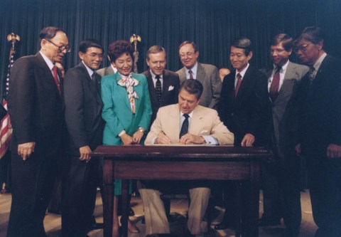
President Ronald Reagan signed legislation that provided for reparations to Japanese Americans who had been imprisoned during Word War II. The bill was sponsored by Alan Simpson, a Republican Senator and Norman Mineta, a Democrat in the House of Representatives. Mineta later became the only Democrat to serve in George W. Bush’s cabinet. (Courtesy Ronald Reagan Presidential Library)
Perhaps I’m a softy, but when I read Karl Raymond’s recommendation to grant a picnic permit, against general policy, I found myself smiling. Way to go, Karl! A little victory for humanity. We can always use more of those—whether you think we’re mostly bad, mostly good or completely woebegone.
Let’s hope we don’t need to find courageous sponsors and signers of legislation forty years from now to correct mistakes we can avoid today.
David C. Smith
©2016 David C. Smith
Lake Nokomis Bath House
One of my favorite pictures of Lake Nokomis. Construction of the bath house was completed in 1920, not long before this photo was taken. The barren landscape — on both sides of the lake — is surprising. (Click the image to enlarge.) This is one of many park board photos that may become available to the public in the near future through the Minnesota Digital Library.

The new playing fields and bath house at Lake Nokomis. Early 1920s. Taken from Cedar Avenue. (Minneapolis Park and Recreation Board.)
What became of that bath house? The Minneapolis Star ran the photo below on May 2, 1966. The building had been declared unsafe, but demolition was prompted by thousands of dollars of damage done by vandals that winter. Only the toilet rooms of the bath house were left standing for the summer of 1966. A new, smaller bath house was built the next summer. At the time it was the most heavily used beach in the city.

David C. Smith
Charles Loring: “We must control the lake.”
Filed under: Loring Park, Minneapolis Lakes, Minneapolis parks | Tags: Charles M. Loring, Florence Barton Loring, Lake Calhoun, Lake Harriet, Lake of the Isles, Minneapolis parks, Minnehaha Falls
Comments (3) If you have read my history of the Minneapolis park system, City of Parks, you may recall that Charles Loring’s efforts to acquire land around lakes Harriet, Isles and Calhoun remain a subject of speculation. No one has ever found a clear strategy or well-documented plan by Loring, the first president of the Minneapolis Board of Park Commissioners, to acquire the lakes, even though he spent the better part of several years in getting those complicated real estate deals done. I focused mostly on Loring’s desire to create a parkway from Loring Park, then still called Central Park, around the lakes to Lake Harriet, which had been acquired already for the fledgling park board largely by gift. Even the generous gift of land around Lake Harriet by Henry Beard, James Merritt, Charles Reeve and, ultimately, William King, was prompted by the desire to have a parkway around the lake, which accounts for the limits of the original gift: a strip of land only 125 feet wide around Lake Harriet—just enough for a walking path, a carriage way and a few trees or flowers to dress it up.
A new discovery suggests, however, that Loring had much more in mind than parkways. As part of the ongoing project to inventory the park board’s historical records with the goal of making them more accessible to researchers, I recently found a letter written by Loring in 1886 that sheds more light on his thinking about the lakes.
The letter, dated June 14, 1886 and addressed to park board secretary Rufus Baldwin, discusses Loring’s views on what needs to be done to acquire land at Lake of the Isles. Loring notes that Alfred Dean, who owned much of the land that had to be crossed by a parkway at Lake of the Isles, had already told Loring he could do whatever he wished. Loring then wrote,
“My opinion is that we do not want the land on the outside, but do want it next the lake. As the plat now is, the boulevard goes around the little marsh thus.”
Loring then includes a small drawing.

Charles Loring’s letter to Rufus Baldwin, June 14, 1886
He is very explicit, writing on the road next to the lake “This is what we want” and concluding bluntly, “We must control the lake.”
This evidence that Loring was thinking far beyond parkways is reinforced by the concluding page of his letter when he addresses a new topic: boats on Lake Harriet. He notes that a steamer has been placed on the lake and he has asked the owner to remove it, but adds that after talking with “Judge Fish”—park board attorney Daniel Fish—Loring doesn’t want legal questions raised yet about “rights on the water”. Clearly, Loring is thinking about park board control not just of boulevards around the lake, but activity on the lake as well. His earlier comment, “We must control the lake”, takes on even greater significance.
We may owe even more to Charles Loring and his vision than we previously knew.
While on the subject of Loring I want to mention a note I received a while ago from, William Scott, the great-great-nephew of Charles Loring’s second wife Florence Barton Loring. You can read more about his family’s relationship with the Bartons and Lorings in the “Comments” section here.
This is the carte de visite of Florence Barton that he refers to. Thanks to William Scott for sharing the photos below.

Florence Barton, date unknown. (Beal Art Gallery, Harold W. Scott Collection, courtesy William Scott)
This must have been taken long before she married Charles Loring at age 45 in 1895. Read much more about Florence Barton Loring here.
William Scott also sent a photograph of family and friends at Minnehaha Falls in about 1910. Love those hats! The new bridge with the boulder face over a concrete structure was brand new in 1910. Appears to be a dry year.

David C. Smith
© 2016 David C. Smith
Arts and Parks: Part II
Filed under: Minneapolis parks | Tags: Minneapolis Institute of Arts, Washburn Fair Oaks, William D. Washburn
Comments (9) Another of my favorite recent photo finds is a good intro to my next speaking engagement on Minneapolis park history this Saturday.
I recently found this photo of the Washburn Fair Oaks mansion built by William Washburn in 1883.

Washburn Fair Oaks mansion, probably in the 1880s. Looking west across Third Avenue South in foreground. (W.S. Zinn)
Compare it to this photo taken two Sundays ago from about the same vantage point across Third Avenue South.

Washburn Fair Oaks Park looking west across Third Avenue South.
Now turn about 90 degrees left and you get this image of the Minneapolis Institute of Arts.

Minneapolis Institute of Arts looking southwest across Third Avenue South.
I’ll be talking about both parks and arts, and how many of the same people created Minneapolis’s parks and its art institutions at the Washburn Library on Lyndale Avenue, Saturday, November 21 at 10 a.m. My presentation is being hosted by the Minnesota Independent Scholars’ Forum, but the event is free and open to the public.
For more information visit here. Hope to see you Saturday.
If you want to know more about the landscaping of the Washburn Fair Oaks grounds, you can begin here. Of course, the story features H.W.S. Cleveland.
David C. Smith