Archive for the ‘Minneapolis Parks: General’ Category
“The Yard” — or Downtown East Commons: A Caution from Minneapolis Park History
Filed under: Minneapolis Park Names, Minneapolis Parks: General | Tags: Downtown East Commons, Pioneer Square, Shingle Creek, The Gateway, The Yard, Vikings Commons, Vikings Stadium, Wold Chamberlain Field
 Comments (20)
 Hurrying to create a park in “The Yard” (since renamed the “Commons”) between downtown and the new Vikings stadium could result in disaster, if the history of Minneapolis parks provides any lessons. The greatest land-use mistakes in Minneapolis park history came from creating parks for purposes other than the relaxation, recreation, entertainment or edification of its citizens. Creating grounds for a pleasant stroll to a stadium eight days a year isn’t reason enough to make “The Yard” work as a park. Planning for those two blocks has to go well beyond landscaping only for the benefit of surrounding property owners, too.
An Expensive Failure: The Gateway
On four notable occasions, the park board has created parks largely for other than “park” reasons. The first, and still most-disastrous, was the creation of The Gateway in 1913 at the junction of Hennepin and Nicollet Avenues just west of old Bridge Square approaching the Hennepin Avenue Bridge. The triangular park was created to be an attractive “gateway” from the railroad station into downtown. The welcome intended for visitors, or travellers returning home, was clear from the words carved in stone on the pavilion at The Gateway:
“More than her arms, the city opens its heart to you.”
That slogan must have sounded less smarmy to 1913 ears than it does to mine. Parks, as well as slogans perhaps, were still on experimental footing in the “new” cities of the American west and The Gateway was the first venture of the Minneapolis Board of Park Commissioners into downtown Minneapolis.
The buildings razed to make room for the park reportedly housed 27 saloons, which for many park advocates was reason enough to create the park. But neither open heart nor closed saloons were enough to make the park successful.
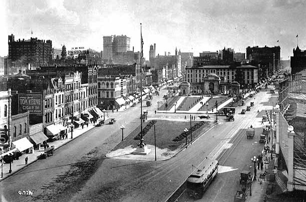
The Gateway 1918 at the intersection of Nicollet Avenue (left) and Hennepin Avenue (right). The Mississippi River and Hennepin Avenue Bridge are behind the photographer, Charles P. Gibson. (Minnesota Historical Society)
By 1923, the park board was spending more than 5% of its annual citywide operating budget on the park, mostly on park police patrols, because, in addition to the city’s arms, the park board had opened toilets – er, “comfort stations” – in The Gateway’s pavilion. The park quickly became a favorite hangout for lumbermen between jobs, as well as the unemployed, indigent or inebriated. What was supposed to get rid of ugliness and beautify the city, became an eyesore itself.

This infamous 1937 photo may overstate the case, but it does suggest one typical use of the park. Notice however that there are no nappers across the street, on the block that holds the pavilion and fountain. (Minneapolis Star Journal, Minnesota Historical Society)
Despite an attractive pavilion and a fountain donated by Edmund Phelps (now in Lyndale Park near the Rose Garden), the park served too few constituents (or at least some the city thought undesirable) and little park purpose beyond decoration. The park was controversial even when it was built, with such thoughtful park observers as former park commissioners William Folwell and Charles Loring opposing the park. Loring’s wife owned some property condemned for the park, but nonetheless he predicted correctly that it would become a home for indigent men. (See Florence Barton Loring’s reflective response here.) The pavilion was closed and leveled in 1953 and the fountain was removed to Lyndale Park in 1963, when the old Gateway ceased to exist. (For the rest of The Gateway story go here, then click on “Parks, Lakes, Trails…”, then “Gateway” in the index.)

Fenced. Desolate. Doomed. The Gateway in July 1954 after demolition of the pavilion, looking toward the river from Washington Avenue. (Minneapolis Star Journal Tribune, Minnesota Historical Society)
The Gateway was by far the most expensive park built during the first thirty years of the Minneapolis park board’s existence. The total cost was nearly one million dollars, more than had been paid to acquire Lake Harriet, Lake Calhoun and Lake of the Isles – plus parks and parkways along both sides of the Mississippi River – combined!
A Huge Success: Wold-Chamberlain Field
The next time the park board was asked to build something for the city turned out quite differently. When Minneapolis needed an airport, the park board was the only municipal entity that could legally own land outside city limits. Therefore, it fell to the park board in 1928 to own and operate the municipal airport on the site of the old motor speedway next to the Fort Snelling military reservation. The park board operated and developed Wold-Chamberlain Field, built it into a respectable airport, and turned it over in the mid-1940s to the newly created Metropolitan Airport Commission. Chalk one up to collaboration among city, park, civic and business interests. The goals, however, were clear, unambiguous and limited – and in the 1920s the airplane was still little more than a curiosity. Few people anticipated the future importance of flying machines and places to land them.

Wold-Chamberlain Field, Minneapolis’s airport, 1941. The passenger terminal is lower right. Owned and developed by the Minneapolis park board, 1926-1943. One of the only success stories when the park board was asked to develop something other than a “park.” (Minneapolis Park and Recreation Board)
A Second Downtown Disaster: Pioneer Square
The next effort at collaboration was much less successful. Like The Gateway, it was downtown. Another cautionary tale. The U.S. government wanted to build a new post office in downtown Minneapolis in 1932, but asked that a proper setting be provided for the building on the west bank of the river just above St. Anthony Falls – a stone’s throw from The Gateway, which was already admittedly a failure as a park. In the grip of Depression, however, the city needed the jobs and the federal money that would be spent, despite what seem to have been the obvious warnings of The Gateway experience.

Dedication of Pioneer Statue in Pioneer Square in front of the post office, 1936. (Minneapolis Park and Recreation Board)
The city asked the park board to build a post office park, but the park board demurred until the city agreed to finance most of the land acquisition instead of having the park board assess property owners. Enough money was left after land acquisition, demolition and improvement to commission a sculpture for the park, which depicted pioneers. Despite the sculpture (now in B.F. Nelson Park) and the attraction of a new, immense post office, Pioneer Square soon followed the path of The Gateway. According to Charles Doell, park superintendent in the 1950s, after the snow melted at the end of the winter of 1953, maintenance crews picked up 70 bushel baskets of empty wine and whiskey bottles from The Gateway. One Monday morning in the summer of 1953, crews picked up 62 empty wine and whiskey bottles from the grass at Pioneers Square. (Charles E. Doell Papers, Hennepin History Museum). Further proof that you can’t just plop green space down in a city and expect it to serve some vague “beautifying” or “park” purpose – even with some dressing up. Pioneer Square also fell to urban renewal in the 1960s. (Read more about Pioneer Square and other “lost” Minneapolis parks here.)
A Drainage Ditch
The fourth instance of the park board acquiring a park for non-park reasons occurred in the far north of the city. The low land around Shingle Creek north of Webber Park often flooded, so was unusable for development. Due to a critical housing shortage for returning soldiers and sailors and their new families after World War II, the city asked the park board to acquire Shingle Creek – from Webber Park to the northern city limit — and lower the creek bed to drain the neighborhood so homes could be built there. The park board very reluctantly complied with the city’s request, even though the park board had higher priorities elsewhere. The effort succeeded in creating new housing lots, but has contributed little to the overall park experience in the city. Creekview Park is certainly a positive in the neighborhood despite its location only a few blocks from Bohannon Park, but Shingle Creek, in places, still resembles what you’d expect of County Ditch Thirteen. (I think Shingle Creek could and should be made a more valuable park resource.)
The Yard. Somewhat off topic, history suggests the advisability of a different name than “The Yard.” It’s kinda folksy and cute, but Minneapolis has twice tried “The (Something)” and both were trouble. (Try writing about them or describing them and you’ll see.) The Gateway and The Parade, both official names, were inevitably shortened to Gateway and Parade. Those two words were distinctive enough to stand alone without creating confusion, at times, but “Yard” isn’t. Whose Yard? Not to mention connotations of prison and the Hennepin County Jail overlooking it. The name may have served Vikings or Wells Fargo or Ryan or Rybak’s marketing efforts, I don’t know its origin, making the place sound homey, as if it was “our” space, personal space, but it has severe limitations for daily usage.
Of these four cases of park building for non-park reasons, the two parks created downtown, The Gateway and Pioneer Square, stand out as dismal and expensive failures. They were built strictly to provide a more attractive setting for other activities and buildings. I’m afraid that is all that the Downtown East Park or “The Yard” is now. And if that is where the discussion remains, it will fail as a park and become an eyesore, a headache or both. Who will go there, why will they go there, what will they do there? What use will be made of the space, what traditions will be shaped there, what memories will be recorded there? If the answer doesn’t involve more than eight Sundays a year, it is the wrong answer. And this is not Chicago, New York, Palo Alto or Cambridge, Mass. It is Minneapolis, which already has parks, lakes, river, streams – and history. Don’t give us someone else’s park and expect it to work.
David C. Smith
© 2014, David C. Smith
Alice Dietz and Bea Dunlap in 1939 Playground Pageant
Filed under: Minneapolis Park Hero, Minneapolis Park Memory, Minneapolis Parks: General | Tags: Alice Dietz, Farview Park, Playground Pageants
Comments (3) I received this note and photo today from Bea Dunlap of Dallas, Texas, under the subject line, “Alice Dietz and me 75 years ago.”
“This picture was taken about 75 years ago (I am now 85 years old) when I was in a Park board pageant representing Farview Park. Me and almost ever kid in my block were Raindrops in a skit called Umbrella Man. The little ones were turtles who hid under a big umbrella until the “sun came out”. Our costumes were made of silver and blue crepe paper. My Mom sewed most of the costumes for our group.”
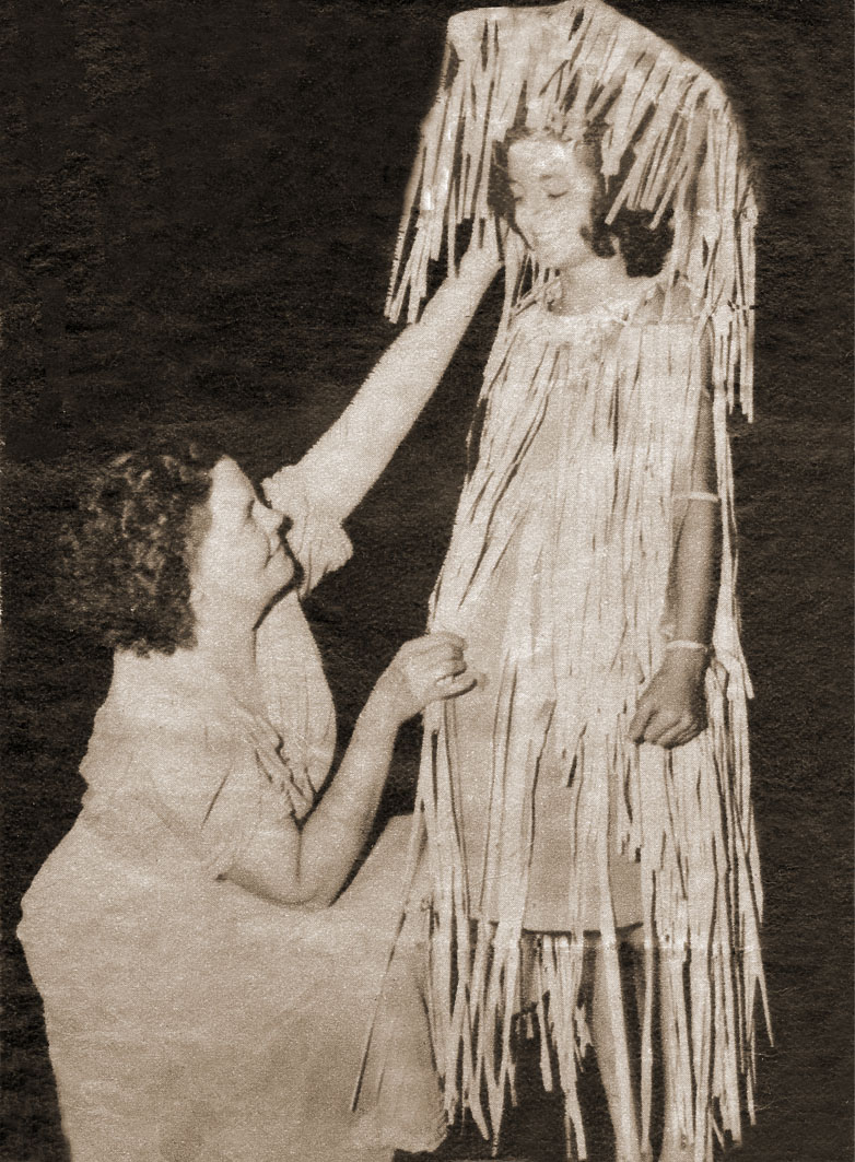
Alice Dietz, creator and director of the playground pageants, with ten-year-old Bea Dunlap from Farview Park in 1939. Bea is dressed as a raindrop. (Photo courtesy of Bea Dunlap.)
The playground pageants, held at the end of summer, included children from every park in Minneapolis. They were presented on the hillside above the Rose Garden at Lyndale Park. The pageants were created and directed by Alice Dietz. This was one of the last playground pageants. With the creation in 1940 of the Aquatennial, that became the focus of summer celebration in the city and the pageant was discontinued.
Thanks for the wonderful photo and information, Bea.
David C Smith
I Finally Made It!
Filed under: Minneapolis Parks: General, Tower Hill Park | Tags: Prospect Park, Tower Hill, Witch's Hat
Comments (6) I finally climbed the Witch’s Hat Tower in Tower Hill Park. The erstwhile water tower was completed in 1914 after the park was acquired by the Minneapolis Board of Park Commissioners. I have already written about the tower here and here and here. Today I’m just providing proof of my climb with photos and a few brief observations.
Most years the tower is only open one night a year, the night that Pratt School has its ice cream social, which was last Friday, but this year the tower will also be opened to celebrate the dedication of the tower 100 years ago. That will take place July 12 and 13. So you get an extra chance to see the view from the top this summer.

The view west toward downtown — and into the sun. Pratt School is at the bottom. I took the picture a little after 5 p.m. I didn’t have to wait in line to make the climb, but by the time I descended about 100 people were in line waiting their turn. (David C. Smith)
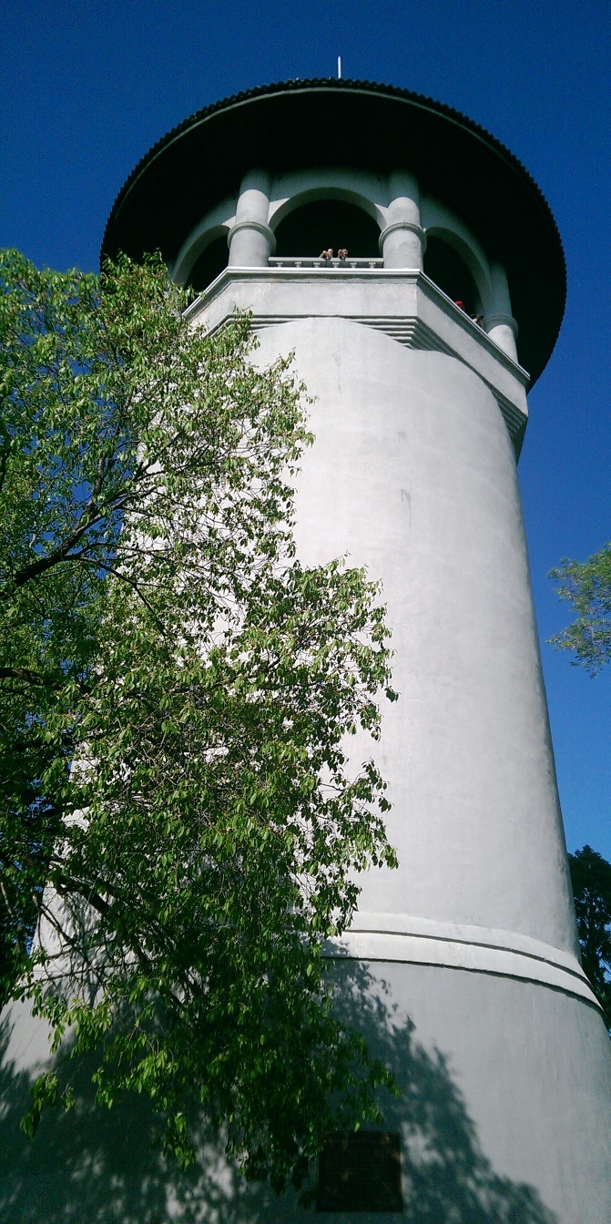
The Witch’s Hat from the terrace near the entrance to the tower. It was a perfect day for a view. It really is this white and sky really was this blue. My Dad, who turns 90 this year, chose not to climb the 100+ steps to the top of the tower, but still enjoyed the spectacular view from the terrace. Even if you miss the few chances to climb the tower, visit the park for beautiful views of the city. (David C. Smith)

The view from the Witch’s Hat to the southwest, across Prospect Park and the Mississippi River into South Minneapolis. This was my favorite view, in part, because of how well the Mississippi River is hidden. You can tell it’s there and you can see part of the railroad bridge over the river, but it is amazing how such a prominent and predominant geographical feature can be swallowed by the landscape. I couldn’t help but imagine the wildness of the view from here 150 years ago — before buildings and also before the Minneapolis park board planted hundreds of thousands of trees along city streets. Early writers note that what is now South Minneapolis, from the river gorge to the lakes in the southwestern part of the city, was mostly treeless prairie. The Tower Hill Park tennis courts are visible in the lower right corner. (David C. Smith)

The top of the stairs down the Witch’s Hat. (David C. Smith)

The spiral staircase of the Witch’s Hat. It was narrow enough that I had press up against the wall and suck in my (shrinking) stomach to pass people going the other way. The large deck at the top of the tower was intended to be a bandstand for concerts, but musicians had a difficult time getting their instruments up this narrow staircase. Imagine lugging a bass, bass drum or tuba up or down. But others were once able to enjoy the view any time. When the tower was first opened in 1914, the park board paid a park keeper to open the tower to the public five days a week. (David C. Smith)
If you took better photos than I did, please email them and I’ll post them here.
David C. Smith
© 2014 David C. Smith
Horace Cleveland Gets a Park!
Filed under: Minneapolis Parks: General | Tags: H.W.S. Cleveland, Horace Cleveland, Mississippi River Gorge
Comments (1) It could finally happen! I was delighted to learn that Minneapolis Park Commissioners Scott Vreeland and Steffanie Musich will introduce to the board this week a formal proposal to name all or part of the Mississippi River gorge in Minneapolis after Horace William Shaler Cleveland. He was the landscape architect who was so influential in the creation of the Minneapolis and St. Paul park systems and, especially, the protection and preservation of the incomparable river gorge as a park.

The cover of the park board’s 1905 annual report shows the Mississippi River gorge looking up river from the mouth of Minnehaha Creek at left. (Minneapolis Park and Recreation Board)
I can think of no higher or more appropriate honor for a man whose vision meant so much to life in this metropolis than to name this magnificent ribbon of untrammeled, still-wild green in his name.
Scott Vreeland has pointed out that the proposal he will read this week is only the beginning of the process that must gain approval now from many jurisdictions, from the Minneapolis Park and Recreation Board to the National Park Service. Perhaps it is indicative of Cleveland’s profound legacy that local, regional, state and national entities are now involved in the continued preservation and administration of the treasure the river gorge has become.
But it is a start. To read more about why I believe this is important, read my earlier articles here and here. Or click on Cleveland’s name in the tag cloud at right to learn a great deal more about this extraordinary person.
Thanks Scott and Steffanie for taking this step.
I hope all other organizations, public and private, that are interested in the river will support them.
David C. Smith
© 2014 David C. Smith
Perkins Hill Park Was Not Named for Frances Perkins
A few days ago Wendy Hajicek commented on an earlier post, mentioning her memories of Perkins Hill. Wendy asked if Perkins Hill was named for Frances Perkins the Secretary of Labor in the Cabinet of Franklin Delano Roosevelt. I had written in a historical profile of Perkins Hill for the Minneapolis park board’s website that the park was named for the Perkins Hill Addition, a property development. Park board proceedings from that era do not indicate that the name was ever formally approved. It is one of those “so-called” properties.
I had never heard before the possibility that the park had been named for Frances Perkins, so I quickly looked up the time frame of the acquisition to see if it would have been possible. The park was acquired in 1948 and Frances Perkins had served in Roosevelt’s cabinet from 1933 to 1945. The time period fit perfectly.
So then I went back to the plat maps from 1914, 1903 and 1892 that I consult so often from the Minnesota Digital Library and the Borchert Map Library at the U of M. I wanted to see how the property was named at those times. The name Perkins Hill Addition is on the 1903 plat map and the 1892 plat map notes that four adjoining parcels of land are owned by people with the Perkins surname. So it appears that the name is based in Minneapolis, not Washington, D.C.

Frances Perkins, Secretary of Labor, 1933-1945.
I haven’t looked up the Perkins family that owned, then subdivided, the north Minneapolis property in the late 19th century. Perhaps they were leading citizens of the community and I wouldn’t want to diminish their part in the early history of Minneapolis, but part of me was hoping that the park could have been named for Frances Perkins, the first woman to serve on a presidential cabinet and, therefore, the first to take a place in the line of succession for the presidency. A brief online exploration of her life suggests that she was influential in formulating Roosevelt’s labor policies, Depression-era work relief programs, and the creation of social security.
I’ll look for info on the Perkins family of north Minneapolis as well. If you know any of their story, let me know.
And as I mentioned in my reply to Wendy’s comment, I hope more people stop by Perkins Hill Park for a picnic or a visit. The view of the city is splendid. Does anyone have a photo to share?
David C. Smith
© 2013 David C. Smith
Approaching Lake Calhoun — A Couple Years Later
Filed under: Minneapolis Parks: General | Tags: Dean Parkway, Lake Calhoun
Comments (5) Julieann Swanson, Assistant Curator of Digital Collections and Archives at the University of Minnesota’s College of Design just sent a fabulous photo of the Lake Street, Dean Parkway, and West Calhoun Parkway intersection from about 1956 in response to my post earlier today. See Julieann’s comments on that post for more information on this photo and the Digital Content Library.
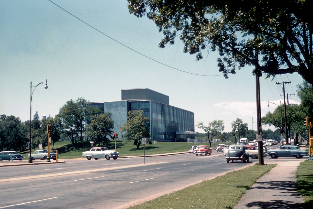
Looking west on Lake Street toward the intersection with Dean Parkway and West Calhoun Parkway. (Photo: University of Minnesota, Digital Content Library)
Julieann suggested that the photo is circa 1955, but I’ve advanced it a year to 1956, because I believe that is a red 1956 Chevy sitting at the east-bound stop light. And, yes, the traffic lights are quite visible in this photo! Would that car have been called, “Cherry”? I’m a little too young to remember ’50s slang.
Thanks, Julieann.
David C. Smith
© 2013 David C. Smith
Approaching Lake Calhoun
Filed under: Minneapolis Parks: General | Tags: Dean Parkway, Lake Calhoun, William Berry Parkway
Comments (7) Two photos from the 1950s, and two that are much older, show how people got to Lake Calhoun once upon a time. Both photos are from the Minnesota Historical Society’s online collection. I haven’t written about that collection in some time, but I continue to use it extensively for research on Minneapolis parks and other historical subjects. You should take a look if you haven’t before. It’s a treasure.
The first photo shows the intersection of Lake Street, Dean Parkway and West Calhoun Parkway, looking west.
Many Minneapolis parkways were once called “boulevards”, but that changed in 1968 when the Minneapolis park board renamed nearly all of them “parkways.” The park board wanted to create uniformity in treatment, but also believed that by calling them parkways, people would better understand that they were owned by the park board and were part of the park system. I still refer to them as boulevards at times, out of habit, as do many others. Curiously, Google maps hedges, labelling the road around the west side of Lake Calhoun “W Calhoun Pkwy” and “Calhoun Blvd”.
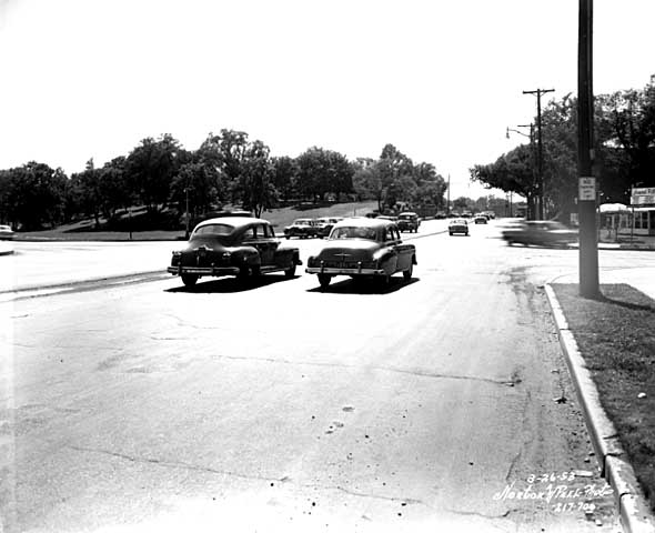
Travelling west on Lake St. at Dean Parkway. West Calhoun parkway begins at far left. (Norton and Peel, Minnesota Historical Society)
Note that the lot on the southwest corner of the intersection (upper left) is still undeveloped in 1953.
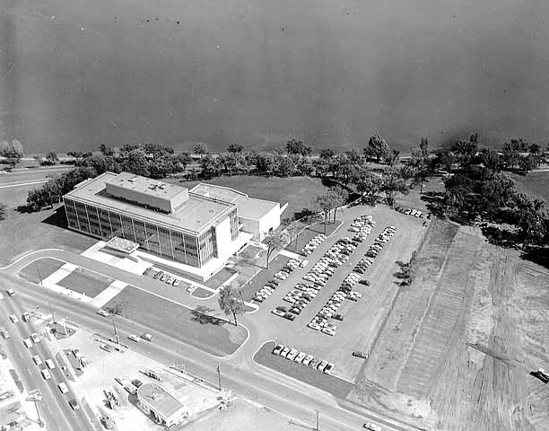
Aerial view, 1956. Excelsior Blvd. is in the foreground. Minnesota Historical Society)
The earliest photos I’ve found of the American Hardware Mutual Insurance Company building on the site are dated 1956, such as this aerial photo from the Minneapolis Star Journal Tribune.
The park board never owned that piece of land, although it would have been a good addition to the lake park. The park board reported in 1916 that the purchase of 93 acres on that corner was pending, but the deal never was completed. The land behind the building to the southwest was once a small bay of the lake, which the park board filled with material dredged from the lake bottom.
Perhaps it’s simply an issue of the resolution of this photo, but I don’t see traffic lights even though it appears that east- and west-bound traffic is stopped. The lights must have been installed about this time, because the city engineer had developed an initial plan for lights at this increasingly busy intersection in 1951.
The photo below was taken at the opposite, or southeastern, corner of Lake Calhoun at about the same time.

36th Street approaching the southeastern corner of Lake Calhoun, 1955. Lakewood Cemetery is on the left. (Norton and Peel, Minnesota Historical Society)
The photo is notable especially because the foundation of the street railway bridge over 36th Street still stands. This was the location of the rails that went to Lake Harriet and beyond to Excelsior and Lake Minnetonka. Of course, there were no traffic lights at the intersection of 36th and East Calhoun Parkway either.

East Calhoun Parkway in about 1890. Looking north from Lakewood Cemetery.(Minnesota Historical Society)
The trestle had been there since before the park board built the parkway. (See more on the Lyndale Railway Company at Lake Calhoun and Lake Harriet.) In the photo at right you can see the bridge foundation (far right), in front of the carriage turning east onto 36th Street. The fountain in the boulevard for watering horses was an interesting touch. So was the scalloped hedge between the parkway and the lake. Does anyone know when the street railway bridge supports were torn down?
Most of the earliest parkways around lakes ran right along the water’s edge. That feature of early parkways is more prominent in the photo below of the end of Calhoun Parkway in about 1905. At that time the parkway ended where it turned south to connect to Lake Harriet. The land behind the photographer in this photo was private land all the way around the west shore of the lake back to Lake Street and the top photo.

The end of Calhoun Parkway at the south end of Lake Calhoun in 1905. The road turned to the right, the future William Berry Parkway, connecting to Lake Harriet. (Minnesota Historical Society)
The photo below shows the approach to the north end of Lake Calhoun from about the same time period as the photo above.

The north shore of Lake Calhoun from Lake Street, facing west in about 1902. (Minnesota Historical Society)
This photo shows Lake Street facing west at the northeast corner of Lake Calhoun. This was before the park board acquired the north shore of the lake. The only park land around the lake at this time was Calhoun Parkway beginning at the left of this photo and continuing to the previous photo.
David C. Smith
A Missed Opportunity: The Witch’s Hat Is Closed for Another Year!
Filed under: Minneapolis Parks: General, Tower Hill Park | Tags: Frederick W. Cappelen, Tower Hill Park, Witch's Hat
Comments (6) 
The view from Tower Hill — at the base of the Witch’s Hat. Imagine the view from the observation deck above. (Talia Smith)
For years my “To Do in Minneapolis” list has included a climb that I have never made. And it’s not something I can do just any old day. We get one evening a year and that’s it. And once again I missed my chance. I wasn’t paying close enough attention that the Prospect Park/Pratt School Ice Cream Social was May 31. The night of that neighborhood party is the one time a year that the Witch’s Hat Tower on Tower Hill Park is open for climbing.
The climb would have been especially gratifying this year because it was the tower’s 100th birthday. The City of Minneapolis built the water tower on the hill, with the park board’s permission, in 1913. As explained before, the park was already named Tower Hill, at the request of neighborhood residents, when the Witch’s Hat water tower was built.
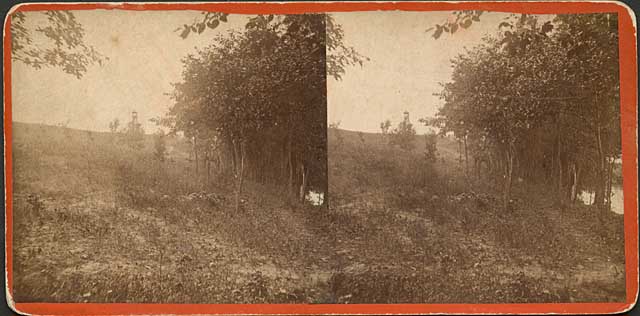
Since my earlier post on the Witch’s Hat, I found this stereopticon image of “Cheever’s Tower” dated 1858. (Minnesota Historical Society)
The Witch’s Hat tower was designed by Frederick Cappelen, as noted on a plaque that was put on the tower in 1999. I have a complaint about that plaque.
Cappelen is described on the plaque only as a “Norwegian architect.” Concise, but really misleading. Yes, he was Norwegian by birth, but he had immigrated to the United States at the age of 23 in 1880. He went to work for the City of Minneapolis in 1886 as a bridge engineer and in 1893 was elected Minneapolis’s City Engineer. He left that office in 1899, but was elected City Engineer again in 1913 and held that title until he died of complications from appendicitis in 1921. So, although Norway-born, he lived nearly his entire adult life in Minneapolis and during much of that time was a city employee.
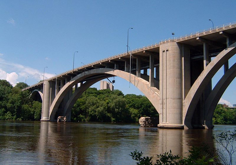
The graceful arch of the bridge was the world’s longest concrete span at the time it was completed in 1923. (Mulad)
Cappelen’s greatest achievements in Minneapolis had nothing to do with the Witch’s Hat. He was the designer of the Franklin Avenue Bridge over the Mississippi, which was completed after his death. At that time, the bridge was the longest concrete-span bridge in the world, with a central span of 400 feet. The bridge’s official name is F. W. Cappelen Memorial Bridge.
Cappelen was also a key figure in designing the city’s water distribution system from the 1890s into the 1900s. He was so well-known as a bridge designer and a water works designer that his obituary was included in both the Proceedings of the Society of American Civil Engineers and the Journal of the American Water Works Association.
Cappelen was a Public Servant
Here’s my complaint about the plaque. I have no problem with identifying him as a “Norwegian architect” despite the fact that he was as American as everyone else in the city. My problem is with not identifying him as a public employee, as the City Engineer, a description that has far more to do with our memory of him than that he was Norwegian by birth.
The omission of his status as a public employee is part of my larger complaint that too many people praise everything in the private sector and disparage everything and everyone in the public sector. Too many people have such blind reverence for business methods and profit motives that they cannot distinguish between public and private good and the sometimes vastly different challenges involved in each. Some public problems cannot be solved by methods designed to maximize private profits.
I have also witnessed first-hand brilliance, stupidity and sloth in both government and corporate worlds. I have known very successful business people whom I would not trust to walk my dog around the block for fear that they’d screw it up somehow — or sell my dog before they made it back. I have known public employees with whom I would trust my life.
I have no tolerance for people who assume that someone who gets his or her paycheck from a government entity is incompetent and that everyone who works for a profit-making enterprise is more industrious and resourceful.
I have as much tolerance — none — for those who assume the only reason we have parks at all was a conspiracy of capitalists to enrich themselves. This myopic view, in my recent experience, seems particularly prevalent among people writing doctoral dissertations and some of those advising them.
To emerge from our present political quagmire, we have to be better than those extremes.
If there is a valuable lesson in Minneapolis park history it is that a great variety of people, with disparate philosophies and political views, have worked together on issues of the common good and achieved marvelous results. They included “capitalists” who looked beyond self-interest and profit, and they certainly included talented and dedicated public servants — like Frederick William Cappelen, City Engineer.
I’m sorry I missed again a chance to climb the tower he imagined 100 years ago. I’ll have to settle for a walk over his bridge.
David C. Smith
NOTE (6/6/2013): abockheim raises an excellent point in a comment on the post I linked to above about the identity of the tower that led to the naming of Tower Hill. Can anyone shed light?

An illustration of the view from Cheever’s Tower in 1857 by Edwin Whitefield. The lithographer was W. Endicott & Co. (Digital gallery of the New York Public Library.)
Here’s the link to the above illustration. I can’t picture this view from the campus or Tower Hill.
© David C. Smith 2013
Minneapolis Sculpture Garden is 25
Filed under: Minneapolis Parks: General | Tags: Armory Garden, Minneapolis Sculpture Garden, The Parade
Leave a comment Happy 25th Birthday Minneapolis Sculpture Garden!
Sorry, I forgot to inform you of the original air date of tpt’s history of the Minneapolis Sculpture Garden. It premiered last Sunday evening on tpt/MN. The half-hour documentary was made to celebrate the 25th birthday of an extraordinary public space.
The program will air again at various times throughout the summer. Check tpt schedules or watch it here.
Producer Mark Fischer and executive producer Tom Trow did an excellent job telling the story; they even let me be in it!
The Sculpture Garden was a collaboration between the Minneapolis Park and Recreation Board, which owns and maintains the land, and the Walker Art Center, which designed the garden and selected the sculptures. It’s a Minnesota treasure.
The following photos show the transformation of part of the Sculpture Garden when the Armory Garden was created in 1913.

The southern half of the Sculpture Garden site before it was designated to become a garden in 1913, looking southwest, Armory in background, Walker Art Center site at left, Lyndale Avenue in lower left, Kenwood Parkway, now closed at right. (Minneapolis Park and Recreation Board)

The same site as above ready for planting for the 1913 convention of the Society of American Florists and Ornamental Horticulturists. (Minneapolis Collection, Hennepin Country Library)

The 1913 Armory Garden. The photo was taken from the Palace Hotel between The Parade and Loring Park. (Minneapolis Park and Recreation Board)
Whether you love the Sculpture Garden, or don’t really care, it is a remarkable use of parkland — one of many examples in the Minneapolis park system. As I said in the video, I think the transformation of one corner of a recreation park into an art park is a remarkable example of how the use of public land can — and should — change over time. It’s another tribute to the wisdom of those who envisioned the park system and the need to set aside land for public enjoyment. Because we own the land, we can adapt its use to meet our needs, however they may be defined and redefined. Brilliant!
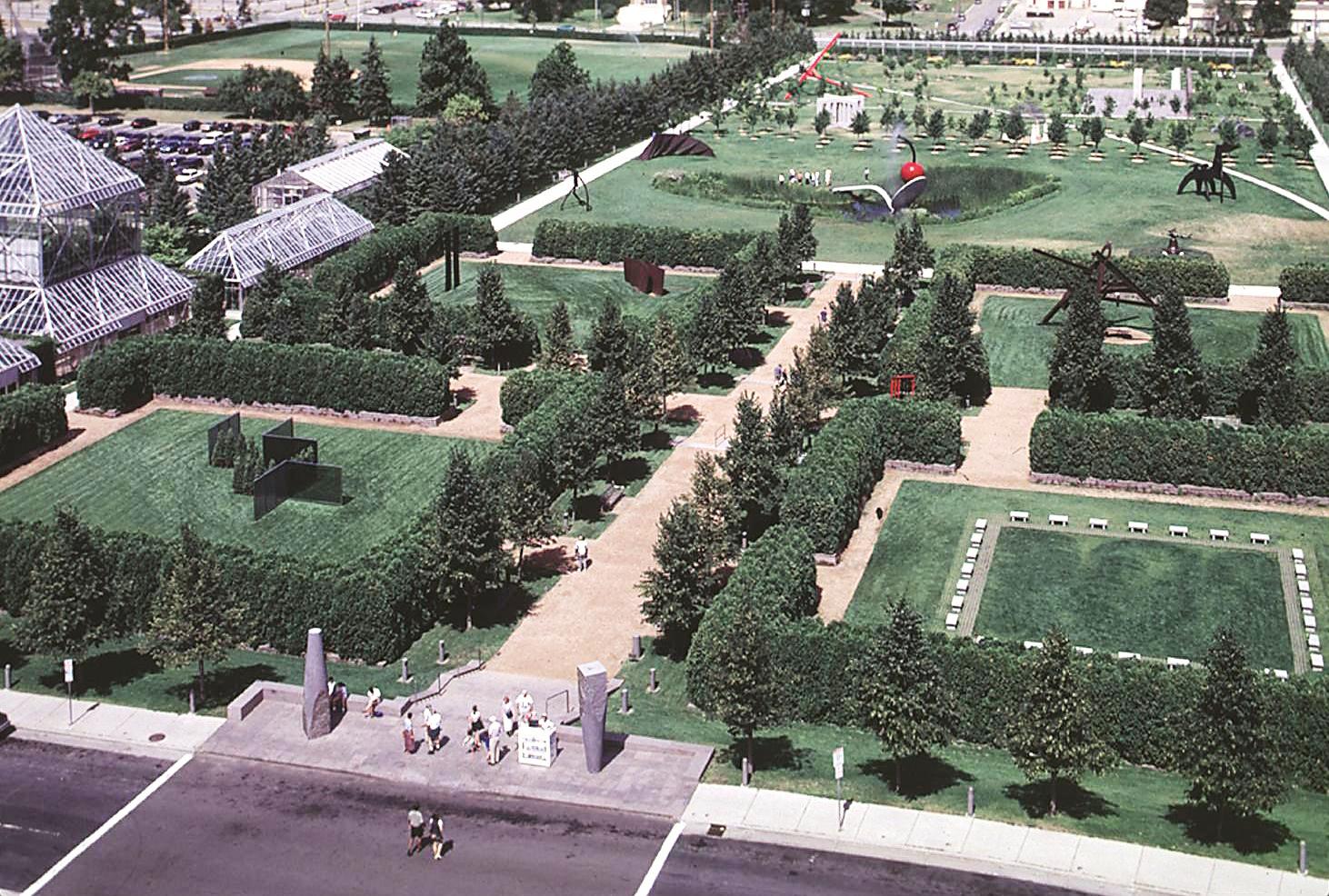
The same land in the photos above, but seen from the south. (Minneapolis Park and Recreation Board)
When’s the last time you visited the Sculpture Garden? Maybe it’s time to take another look.
David C. Smith
© 2013 David C. Smith
Friday Photo: Before the Mills Were Ruins
Filed under: Mill Ruins Park, Minneapolis Parks: General, Mississippi River | Tags: Mill Ruins Park, Mississippi River, Stone Arch Bridge
Comments (8) Let’s go down to the river one more time. I have many favorite pictures of the riverfront when it was the economic engine of Minneapolis, but this is probably at the top of my list.

The west bank of the Mississippi River in downtown Minneapolis, just below St. Anthony Falls, in 1885. (Minnesota Historical Society)
You can see just a dash of the still-new Stone Arch Bridge on the right margin of the photo. The channel here is all tail race — the water that ran out of the mills after generating power.
My favorite part of this photo though is the trestle and railroad tracks that ran between the mills and the river at essentially the level of city streets. Those tail races coming out of the mills are now a part of Mill Ruins Park. The trestle and tracks are gone, but I don’t know when they were torn down. Anybody?
Below are two shots (a 3-for-1 Friday Photo!, the biggest Friday Photo discount ever) of the tail races as they appeared probably in the 1950s.

Tail races, some of which are now visible in Mill Ruins Park. (MPRB)

A closer look at the trail races and water returning to the river after its work was done. (MPRB)
Both photos are undated. They show the water coming out of the tail races. They give a much better sense of the management of water power. I’m not sure of the functions of structures and workers at this point in the water power process.
These structures were razed and covered when the Upper St. Anthony Falls Lock and Dam was built in the 1960s.
For a marvelous 360-degree panorama of Mill Ruins Park and the adjacent lock and dam go here, courtesy of the National Park Service. Learn much more about the lock and dam — one of the biggest mistakes Minneapolis and the U. S. Army Corps of Engineers ever made — at the pages of the Mississippi National River and Recreation Area.
Have a look around the park — if spring ever comes. The transformation is amazing — and thought-provoking.
David C. Smith
© Copyright 2013
Friday Photo: West Riverbank from the Stone Arch Bridge
Filed under: Mill Ruins Park, Minneapolis Parks: General | Tags: Mill Ruins Park, Stone Arch Bridge
Leave a comment I don’t want to overdo the Stone Arch Bridge, but will run that risk with this photo found by Andrew Caddock at the park board. I showed the picture recently to a group of local history buffs and asked for guesses on when it was taken. Guesses ranged mostly from 1930-1960s. The real answer is ….
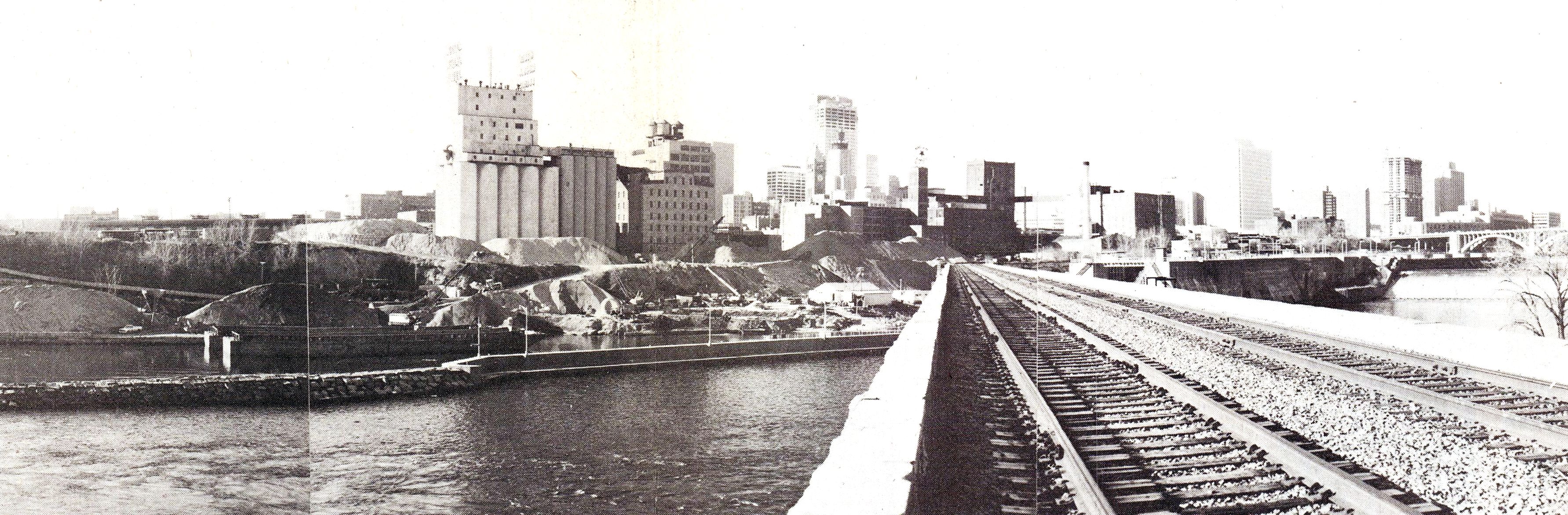
View from the Stone Arch Bridge. Click for larger image. (Jim Keane, Riverfront News)
…1980. Not that long ago.
The piles of sand and aggregate in front of the old mills were used to make concrete and were owned by Shiely Co. The materials were mixed on site and used in downtown construction projects; the sand and gravel could be transported at much lower cost by barge than by truck. The company first used the area for aggregate storage when it was making the concrete to build the upper lock and dam — on the right of the bridge — which was completed in 1965. Train traffic on the Stone Arch Bridge had stopped a couple of years before this photo was taken.
The photo appeared in the December 1980 issue of Riverfront News, a publication of the Minneapolis Riverfront Coordination Board, which included representatives of the major agencies of Minneapolis government.
The land under the sand piles is now Mill Ruins Park. The Guthrie Theater would be near the left edge of the photo
David C. Smith
Sisters of Chuckie: Powderhorn Park 1926
Filed under: Minneapolis Parks: General, Powderhorn Park | Tags: Doll Parades, Powderhorn Park
Comments (3) How did the cherished toys of one generation become scary to their great-grandchildren?
This photo raises the question. Doll buggy parades were big events at parks decades ago, especially in the 1930s. I’ve seen several photos of such events, some as recent as the 1970s. Yet, I’ve seen girls of today react very negatively to pictures of old dolls like these. They find them creepy. But aren’t these dolls more realistic and less creepy than many of the “fashion” dolls that girls play with now?

Dolls on parade at Powderhorn Park, 1926 (Minneapolis Park and Recreation Board)
Cool buggies, too. But with no children in sight? Yeah, they really are kinda creepy. The dolls look better with kids in the picture.

This Minneapolis Tribune photo from 1934, which includes girls from an unidentified park, is more appealing. (Minneapolis Photo Collection, Hennepin County Library)
Do you remember these events? Do you still have the dolls?
David C. Smith