Minneapolis Park Memory: Coach Marv Nelson
Filed under: Minneapolis Park Memory, Minneapolis Parks: General | Tags: Folwell Park, Football, Marv Nelson
 Comments (13)
 I was at a Patrick Henry Foundation ‘doings’ a couple of weeks ago and Marv Nelson’s name came up. Marv was a milk driver for Ewalds or Clover Leaf, but his passion was sports. He coached baseball, football, and hockey and the Cootie VFW was the sponsor, so his teams were the ‘Antsinpants’, but also called Marv’s Boys. It’s not like there was just one team. There were peewees, cubs, and midgets and Marv would have players on the midget teams coach the cubs and the peewees. Marv followed the Henry thing, so everything was red and gray. He always wore a sweat shirt, khakis (work pants, not dockers) and a red ball cap. He had glasses, a snarl and a cauliflower ear. He was ancient in 1965 and coached several more years. He was at Folwell, Bohanan, Shingle Creek. Any given spring there were at least 100 kids on Marv’s Boys teams. The northside never saw anyone like him.
The VFW also sponsored a “Cootie Bum Band” which would march in parades far and wide all through the 70s.
Jim Krave
Where is De Soto Harbor?
Filed under: Minneapolis parks, Mississippi River | Tags: De Soto Harbor, Ford Dam, Mississippi River, Stone Arch Bridge
Comments (5) With the completion of the High Dam, now the Ford Dam, on the Mississippi River just upstream from Minnehaha Creek in 1917, the Minneapolis park board was pressed to name the new reservoir that formed behind the dam. Without explanation, it settled on the odd name of “De Soto Harbor” on July 3, 1918. I have found no evidence that the name was ever changed, rescinded — or used.

The “High Dam” nearing completion in 1917. It became known as the Ford Dam in 1923. This was before the Ford Bridge was built later in the 1920s. (from City of Parks, Minnesota Historical Society)
The harbor was named for Hernando de Soto, the Spanish explorer who was believed then to have been the first European to see the Mississippi River about 1540. De Soto’s expedition never got anywhere near Minnesota, however, crossing the Mississippi near Memphis, Tennessee. De Soto’s story is one of some “firsts” in European exploration of North America, but also considerable brutality toward native people.
Other names the park board considered for the reservoir were Lafayette Lake, Liberty Lake, Lake Minneapolis and St. Anthony Harbor. (Minneapolis Tribune, June 27, 1918.)
The name chosen was unusual because the park board had not, for the most part, named park properties for people not connected with the history of the city or state. (Logan Park was a notable exception.) The decision to name parks only for people of local historical significance was adopted as an official policy of the park board in 1932. The policy was revised in 1968 to enable Nicollet Park to be renamed Dr. Martin Luther King Park.
Of course, some park features on the Minneapolis map—such as St. Anthony Falls, Lake Harriet, Lake Calhoun, Minnehaha Creek—predate by decades the creation of the park board in 1883.
The park board had been involved in issues surrounding dam construction for years by the time it named the reservoir, first with the Meeker Island Dam and later the “High Dam.” From as early as 1909 the park board had sent representatitives to meetings on high dam construction held by the US Army Corps of Engineers and in 1910 had requested that the park board receive half the electricity generated by the dam in exchange for “flowage rights” over land the park board owned. The government did not agree, even though the park board lost 27 acres of land for the reservoir in 1916. Included in that acreage were several islands in the river. The park board granted rights to cut down timber on one island in the river to a local charity before the trees were submerged. The board noted that neither the park board nor the Corps of Engineers wanted a stand of dead timber in the middle of the new reservoir.
Few photos I have seen give a good picture of water levels in the Mississippi before the dams were built. One of the most dramatic is this one of the Stone Arch Bridge in 1890.

Stone Arch Bridge 1890, before any dams downstream created reservoirs. (Minnesota Historical Society)
I don’t know what month the photo was taken, although foliage says summer. Perhaps the river was unusually low in late summer, but to see the Stone Arch Bridge nearly completely out of the water is unusual.
David C. Smith
You Think a Dog Park Was Controversial?
Filed under: Minneapolis parks | Tags: Dr. Martin Luther King Park, Dr. Strangelove, Nicollet Park, The Parade
Comments (1) After holding public hearings and receiving “various communications objecting to it,” on April 20, 1960, the Minneapolis park board rescinded an agreement with Minneapolis Civil Defense to build a “demonstration atomic bomb fallout protective shelter” in Nicollet Park. The board granted permission to build the demonstration fallout shelter at The Parade instead. Was it ever built? I don’t know.

This 1960 instructional booklet included plans for a fallout shelter, presumably similar to the one Minneapolis Civil Defense wanted to build at The Parade. This image is from authentichistory.com. The booklet is also available for sale on e-Bay at the time of this posting–if you’re still worried, or think it would do any good.
In 1968 Nicollet Park was renamed Dr. Martin Luther King Park. The park was the focus of bitter debate over the past year. The issue was whether converting a small portion of the park into an off-leash dog park would desecrate the memory of Dr. King. The dog park was not built.
During the 1960 meeting at which the board approved the fallout shelter, it also granted permission to the Twin City Walk for Peace Committee to hold an open air meeting at The Parade at the conclusion of a “peace walk.”
As a point of reference, Stanley Kubrick’s classic film of the atomic-bomb age, Dr. Strangelove, was released in 1964.

David C. Smith
Minneapolis Park Crumbs I: Morsels Left Behind from Park Research
Filed under: Minneapolis parks, Mississippi River | Tags: Lake Calhoun, Minnehaha Park, Mississippi River
Comments (2) Outlawed: The possession or sale of heroin, other opium derivates, and cocaine without a prescription. Penalties established of $50-$100 fine or 30-90 days in the workhouse. Minneapolis City Council Proceedings, October 10, 1913.
Approved: Spanish language classes for Central and West high schools. Existing faculty at each school will teach the classes. Action of the Minneapolis School Board reported in the Minneapolis Tribune, January 13, 1915.
Suggested: A cement wall between Lake Calhoun and Lakewood Cemetery if the city would continue to permit ice to be cut from the lake. From Minneapolis Journal article, June 8, 1901, about the visit to Minneapolis of Dr. Henry Marcy, “the eminent surgeon and philanthropist of Boston.” Dr. Marcy made the suggestion when he visited Lake Calhoun with Charles Loring. He said he had heard a great deal about Minneapolis’s parks and had a Minneapolis map on which he had sketched out their locations, but wanted to see them.
Found: Gold in Hennepin County, the best sample near Minnehaha Park. The specimen recovered by Prof. J. H. Breese, a former professor at Eastern universities, was confirmed as gold by state geologist Prof. N. H. Winchell. Prof. Breese believes the particles were carried from higher latitudes during the drift period, “but he is quite confident that all has not yet been found.” Reported by Minneapolis Tribune, July 17, 1889.
Built: A 100-foot steamboat named “Minneapolis” by Hobart, Hall and Company. Will begin running freight between Minneapolis and St. Cloud in late July. The company asked the Board of Trade for a free landing near Bassett’s Creek. Reported by Minneapolis Tribune July 8, 1873. The company planned to build another steamboat for the same route, more if “expedient.”
David C. Smith
Phelps Wyman: Pioneer Landscape Architect and Minneapolis Park Commissioner
Filed under: Landscape Architects, Minneapolis parks | Tags: Minnehaha Creek, Mt. Curve Triangle, Phelps Wyman, Thomas Lowry Park, Virginia Triangle, Washburn Fair Oaks
Comments (6) Several pioneer landscape architects were associated with Minneapolis parks, from H. W. S. Cleveland, in a very big way, to Warren H. Manning, more modestly, to Frederick Law Olmsted, who once wrote a letter to Minneapolis park commissioners at Cleveland’s request. But only one pioneer landscape architect was also elected to the Minneapolis Board of Park Commissioners: Phelps Wyman. (He never used his first name, Alanson, so I won’t either.) Wyman’s pioneer status in landscape architecture was determined by Charles A. Birnbaum and Robin Karson in Pioneers of American Landscape Design, which profiles about 150 American landscape architects.
Wyman is also one of a very few landscape architects not employed by the Minneapolis park board to have had designs for Minneapolis parks published in annual reports of the park board. The 1922 annual report presented Wyman’s plan for Douglas Triangle, now Thomas Lowry Park, which I wrote about here. This plan was executed in 1923. Curiously, I can find no record that Wyman was paid for the work.

Wyman’s plan for pools and pergola in 1922 annual report of the Minneapolis Board of Park Commissioners
The next year he had another interesting plan published in the park board’s annual report, but it was never implemented. Wyman’s plan for Washburn Fair Oaks Park across from the Minneapolis Institute of Arts (MIA) Read more »
More Horace W. S. Cleveland: A Bit of Oak Lake and More of Kenwood Parkway
Filed under: Landscape Architects, Minneapolis Parks: General | Tags: H.W.S. Cleveland, Horace Cleveland, Kenwood Parkway, Oak Lake
Comments (1) Since I wrote about Oak Lake and speculated whether Samuel Gale might have hired Horace Cleveland to lay out his Oak Lake Addition to Minneapolis — it had the look of Cleveland’s work — I have been digging through notes to see if I could find a connection between the two men. I couldn’t find anything that put the two of them together in 1873 when Gale was platting Oak Lake, but I did find two interesting pieces of paper linking Cleveland with Oak Lake and with Gale in 1886.
One connection between Cleveland and Gale in 1886 comes from the Frederick Law Olmsted Papers at the Library of Congress. Read more »
Minneapolis Parks 100 Years Ago
Filed under: Minneapolis Parks: General | Tags: Theodore Wirth, Wilbur Decker
Comments (1) The Minneapolis park board and other park activists in town have a full plate this year: a new park superintendent, reorganization and significant staff turnover, Minneapolis Riverfront Design Competition and Initiative, development of Boom Island and B. F. Nelson parks, proposed green finger of parks running into downtown from the river through Gateway Park past the library, potential power plant—Crown Hydro—on park property, and a budget inadequate to do much else. Those are only a handful of the bigger challenges.
But, hah!, Wilbur Decker and Theodore Wirth, park board president and superintendent respectively in 1911, would smirk at this puny agenda. It’s nothing compared to what the park board did 100 years ago. Here’s a summary of what the park board accomplished in 1911. Read more »
Horace Cleveland Hated Rectangles
Filed under: Landscape Architects, Minneapolis parks | Tags: Forest Heights, Glen Gale, H.W.S. Cleveland, Horace Cleveland, Oak Lake, Samuel Gale
Comments (2) Oak Lake Addition was a rare real estate development in Minneapolis because the streets followed the contour of the land instead of a grid pattern. While I’ve found no evidence of who was responsible for the layout of the addition in 1873, it is reminiscent of Horace Cleveland’s work in St. Anthony Park for William Marshall at about the same time and later in Washburn Park or Tangletown near Minnehaha Creek. Although I find no reference to the project in Cleveland’s correspondence, it is plausible that he was involved in the layout of Oak Lake Addition.

Oak Lake Addition, platted in 1873. 1892 plat map (John R. Borchert Map Library, University of Minnesota)
Samuel Gale, the man who platted the Oak Lake Addition, had his hands in nearly everything in the young city: School Board, Athenaeum and Library Board, Academy of Natural Sciences, Society of Fine Arts, Board of Trade, City Council, the public lecture series, he even sang in the city’s most celebrated quartet along with his brother, Harlow, and it was later claimed that although nearly everyone speculated in real estate in those days, he was the dean of realtors in the city. Given his wide interests and involvement in civic affairs, it would be incredible if Gale hadn’t been one of those who welcomed Horace Cleveland to the city during his first visits in 1872.
In July, 1873 Gale was the chair of the Board of Trade’s committee on parks, which reported that several “public-spirited citizens” planned to devote considerable time to the issue of parks with “Mr. Cleveland, well-known landscape gardener” before the next Board of Trade meeting. (Minneapolis Tribune, July 18, 1873.) I think it is safe to assume that Gale himself was one of those who planned to meet with Cleveland. So it appears almost certain that Gale and Cleveland knew each other and had likely discussed park issues before Gale produced his plat for the Oak Lake Addition.
Absent information on who designed Oak Lake Addition, it’s fun to speculate that Cleveland may have had a hand in it, or at least influenced it through the book he published in early 1873, Landscape Architecture as Applied to the Wants of the West. In his classic of landscape architecture, Cleveland expressed his distaste for the grid pattern of streets in so many cities, because it ignored “sanitary, economic and esthetic sense.”
“Every Western traveller is familiar with the monotonous character of towns resulting from the endless repetition of the dreary uniformity of rectangles,” he wrote.
While he singled out western cities — it was his book’s theme — it takes only a glimpse of a map of Manhattan to know that rectangularism was not a sin peculiar to the frontier. For New York, however, it was already too late to do anything about that “dreary uniformity”; the West still had a chance to get it right. Cleveland added that “even when the site is level” the rectangular fashion of laying out cities “is on many accounts objectionable.”
He suggested that if blocks had to be rectangular at least they should be Read more »
Lost Minneapolis Parks: Oak Lake, Two Ovals and Two Triangles
Filed under: Lost Minneapolis Parks, Minneapolis parks | Tags: H.W.S. Cleveland, Horace Cleveland, Loring Park, Oak Lake, Samuel Gale
Comments (14) Another convergence: the season of farmers’ markets is upon us and so is a decision on whether the Minnesota Vikings get a new tax-supported stadium. The site favored for a stadium by some Hennepin County commissioners is the Minneapolis Farmers’ Market on Lyndale Avenue just west of downtown and Target Field.
You’d never know by looking at it today, but the site is rich in history. The current market sits in the middle of what was once Oak Lake, one of the attractions of a semi-exclusive and progressive residential neighborhood late in the 19th Century. It was Minneapolis’s second-oldest park. A bandstand near the lake was built in 1881 to host some of the earliest outdoor concerts in the city. The gracefully curved streets of the neighborhood filled with the carriages of wealthier concert goers, while residents of the neighborhood and music lovers without carriages sat on the sloping hillside in what was called a natural amphitheater near the lake.
Oak Lake Addition, platted in 1873. 1892 plat map (John R. Borchert Map Library, University of Minnesota)
Some people say the Oak Lake Addition experienced gentile flight, then white flight, as the neighborhood went from mostly white Protestant to Jewish to black before it finally gave way to industrial and market uses. And it happened fast. But the trendy little neighborhood was probably doomed by something much more benign than ethnic, religious or racial bigotry; the creation of the Minneapolis Board of Park Commissioners helped kill the Oak Lake Addition.
Where do you think Andy Warhol got the idea?
Filed under: Minneapolis Parks: General | Tags: Clinton Field Park, Dorilus Morrison Park, Leo Harris, Minneapolis Institute of Arts
Comments (3) This has nothing to do with parks.
From the Minneapolis Morning Tribune, October 30, 1915.
Artistic tomato cans and beer bottles? No, not now, but maybe in the future. Joseph Breck, director of the Minneapolis Institute of Arts, intimated the possibility in an address before the art division of the Minnesota Educational Association today. “When some future historian,” he said, “comes to write the story of nineteenth century art, will he praise our tomato cans, our beer bottles, as the art historians of our day praise the vases of ancient Greece? I fear not. But our industrial arts are improving so rapidly and we have made such tremendous advances on the hideousness of the Victorian era that the time is not far off when the future historian will find much to occupy him in the decorative arts of the coming day. If my statement is borne out it will be largely because we have trained the children to know and to want what is beautiful.”

Beauty in a Can. Andy Warhol
Nothing to do with parks—except I came across the article while researching park issues, precisely the park board service of Leo Harris. Minneapolis developer Ray Harris once commented to me that there were many big battles on the park board in the days his father Leo served as a park commissioner (1915-1918). “It was not all sweetness and light,” Ray said. I was searching the Minneapolis Tribune for reference to some of those battles, when I found the tomato can quote.
One of Harris’s biggest fights was with park superintendent Theodore Wirth over what Harris considered faulty and inferior paving methods on parkways.
But there was some sweetness and light too. In 1916 Harris donated a 12-inch silver trophy that was awarded to the city’s Sunday League baseball champion each year. I don’t know what became of the trophy or how long it was awarded.
The best Leo Harris story I could find was from the Minneapolis Tribune October 27, 1914, subtitled “One Reason Why He Became a Candidate for the Park Board.” Harris said he was walking near his home in the eleventh ward the previous spring when he encountered an army of young children playing in the street. He tried to count them, but the crowd was too large and fluid, so he offered to buy them all ice cream cones. When it came time to settle, he paid for 49 cones. Harris said he became a candidate for the park board a few days later. Harris was quoted as saying, “I love the Park Lakes, the River Drive, the beautiful Minnehaha, but I also believe in giving the children in congested districts a place to play and play right. It is a shame for a city to give these kids only the streets to play in.”
Leo Harris resigned from the park board in 1918 to enlist in the U.S. Army during World War I.
I wrote in a post earlier today that the Minnesota Historical Society photo collection has a picture of almost everything. Here’s more proof: I searched for Leo Harris and while I didn’t find a portrait, I did find his business!
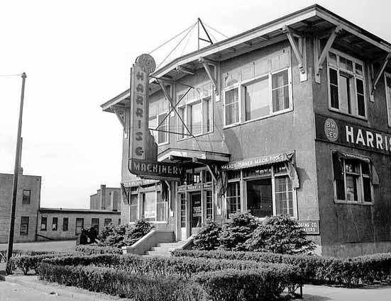
B.W. & Leo Harris Company, 2429 University Avenue Southeast, 1948 (Minneapolis Star Journal, Minnesota Historical Society)
Harris announced the creation of the business in an ad in the Minneapolis Tribune April 23, 1922.
I should also add that the Minneapolis Institute of Arts, of which Mr. Breck was the director when he gave Warhol his inspiration, is located in a Minneapolis park, Dorilus Morrison Park. I knew there would be a picture of that in the MHS collection.

Dorilus Morrison’s home ca. 1900 (Minnesota Historical Society)
This was Dorilus Morrison’s home in about 1900, which his son, Clinton, donated to the park board in 1911 order to build this…
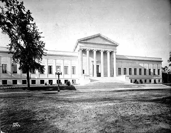
The Minneapolis Institute of Arts, photographed in about 1920, was built in Dorilus Morrison Park. (Charles J. Hibbard, Minnesota Historical Society)
The new Institute opened in January, 1915 and was the site of Breck’s speech later that year. On the day the new building opened, January 7, 1915, a Minneapolis Tribune editorial called it “A New and Powerful Force for Good.”
Dorilus Morrison was instrumental in creating the park board and was a commissioner on the first park board in 1883. Even his son Clinton has a park named for him in a way. Clinton Park was named for its location on Clinton Avenue, but Clinton Avenue was named because it was the street on which Clinton Morrison resided, a block east of his father’s house.
David C. Smith
© 2011 David C. Smith
More on Murphy Square and Augsburg College — and more praise for the Minnesota Historical Society.
Filed under: Minneapolis parks | Tags: Augsburg College, Carl Chrislock, Murphy Square
Leave a Comment In response to my request for info on Murphy Square before the freeway, Juventino Meza, a student at Augsburg College, reports that two books provide stories and photos of the Augsburg campus and the neighborhood before the 1960s. He writes that From Fjord to Freeway: 100 Years of Augsburg College, by Carl H. Chrislock, is available at the Augsburg library. He also recommends From Immigrant Parish to Inner-city Ministry: Trinity Lutheran Congregation 1868-1998, by James S. Hamre. The Trinity Lutheran Church building, once located south of Murphy Square and the Augsburg campus, was taken out by the freeway. The latter book is available from Trinity Lutheran Congregation, which still exists and has an office at 2001 Riverside Avenue and a website here.
I have written often of the amazing resource this state maintains in the Minnesota Historical Society. More than once I have noted that regardless of subject, I always check to see if the Visual Resources Database at MHS has a photo. While looking for photos of Augsburg College and Murphy Square I was astonished to find a photo of Augsburg history professor Carl H. Chrislock, author of the Augsburg history Mr. Meza recommended. Here’s proof.
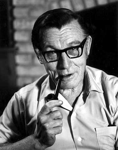
Carl H. Chrislock, professor emeritus, Augsburg College, 1970 (Alan Ominsky, Minnesota Historical Society)
Thanks to Mr. Meza——and to Minnesota legislators for the Minnesota Historical Society. It’s probably a good idea to remind your legislators that the Minnesota Historical Society needs their support.
David C. Smith
Has the Park Board Neglected Northeast Minneapolis?
Filed under: Grand Rounds, Minneapolis parks, Mississippi River | Tags: Columbia Park, Horace Cleveland, Logan Park, Mississippi River, Northeast Minneapolis, Sandy Lake, Theodore Wirth
Comments (2) The argument is sometimes made, particularly by “Nordeasters,” that northeast Minneapolis is park poor and that the Minneapolis park board has neglected that part of the city. “Underserved” seems to be the popular word. The idea even flowed as an undercurrent through the recent Minneapolis Riverfront Design Competition. The thinking goes that ever since Minneapolis and St. Anthony merged in 1872, and took the name Minneapolis, power, money and prestige—not to mention amenities such as parks—have accumulated west and south of the river. (Read Lucille M. Kane, The Waterfall That Built a City, for a fascinating examination of why that might have happened.)
While writing recently about Alice Dietz and the marvelous programs she ran at the Logan Park field house I thought again about the perceived neglect of Northeast and whether it might be true. I concluded that it is not; northeast Minneapolis has been a victim of industry, topography and opportunity, but not discrimination or even indifference. What’s more, all those elements have now realigned, putting northeast Minneapolis in the position to get a far bigger slice of the park pie in the foreseeable future than any other section of the city.
 Minneapolis Park History