Archive for the ‘Horace Cleveland’ Tag
Lost Minneapolis Parks: Highland Oval
Filed under: Lost Minneapolis Parks, Minneapolis parks | Tags: Charles A. Tenney, H.W.S. Cleveland, Highland Oval, Horace Cleveland, Oak Lake, Samuel Gale, Stone Arch Bridge
 Comments (1)
 The elegant neighborhood on the hills surrounding Oak Lake—now the site of the Farmer’s Market off Lyndale Avenue—has been gone for decades. Oak Lake itself was filled in 100 years ago. You can read the whole story here. The latest news: I finally found a picture of one of the five small parks in the Oak Lake Addition. I give you Highland Oval.

The title on the photo is “Highland Avenue, Oak Lake Division”, but the open space in the middle of the photo can only be Highland Oval. The view is looking northwest. Tiny, isn’t it? But the effort to preserve any open green space in rapidly expanding cities was a novel concept. (Photo by Charles A. Tenney)
The photo was probably taken in the mid-1880s, before the park board assumed responsibility for the land as a park. The land was designated as park in the 1873 plat of the addition by brothers Samuel and Harlow Gale. Although I have no proof, I believe it likely that H.W.S. Cleveland laid out the Oak Lake Addition, owing largely to the known relationship between Cleveland and Samuel Gale. The curving streets that followed topography and the triangles and ovals at street intersections were hallmarks of Cleveland’s unique work about that same time for William Marshall’s St. Anthony Park in St. Paul and later for William Washburn’s Tangletown section of Minneapolis near Minnehaha Creek. It was also characteristic of Cleveland’s work in other cities.
Photographer Charles A. Tenney published a few series of stereoviews of St. Paul and Minneapolis 1883-1885. He was based in Winona and most of his photos are of the area around that city and across southern Minnesota.
Highland Oval was located in what is now the northeastern corner of the market.
As happy as I was to find the Highland Oval photo, my favorite photo by Tenney tells a different story.

10th Avenue Bridge. (Photo by Charles A. Tenney)
At first glance, this image from Tenney’s Minneapolis Series 1883 was simply the 10th Avenue Bridge below St. Anthony Falls, looking east. The bridge no longer exists, although a pier is still visible in the river. What makes the photo remarkable for me are the forms in the upper left background being built for the construction of the Stone Arch Bridge. (See a closeup of the construction method here.) The Stone Arch Bridge was completed in 1883 — the same year the Minneapolis Board of Park Commissioners was created.
Nearly 100 years after the bridge was built, trains quit using it and several years later the park board, Hennepin County and Minnesota reached an agreement for the park board to maintain the bridge deck for pedestrians and bicyclists, thus helping to transform Minneapolis’s riverfront—a process that continues today.
Note also the low level of the river around the bridge piers. This was long before dams were built to raise the river level to make it navigable.
David C. Smith
© 2015 David C. Smith
Quotes from “Arts and Parks”: Folwell on Museums
Filed under: Minneapolis Parks: General | Tags: Charles M. Loring, Dorilus Morrison Park, Horace Cleveland, John S. Bradstreet, Minneapolis Institute of Arts, William Watts Folwell
Comments (4) Thanks to everyone who turned out Saturday morning at the Minneapolis Institute of Arts to listen to my thoughts on the people who created parks and a fine art society in Minneapolis in 1883. Special thanks to those who purchased a copy of City of Parks afterwards and introduced themselves. Thanks too to Janice Lurie and Susan Jacobsen for inviting me to speak and hosting the event. I want to remind everyone that all proceeds from the purchase of the book go to the Minneapolis Parks Foundation.
Quite a few of those who attended asked where they could find some of the quotes I used in my presentation, so I promised I would post them here. The most requested, especially from those who work with arts organizations, was William Watts Folwell’s remarks as reported in the Minneapolis Tribune at the laying of the cornerstone of the Minneapolis Institute of Arts in 1913. I’ve provided an excerpt of his remarks from the July 31, 1913 issue of the newspaper, as well as quotes from Charles Loring and Horace Cleveland from earlier times as noted — most of which have appeared in other posts here over the years.

Folwell’s remarks included these observations on his hopes for the Institute:
“ The primary function of the institution will naturally be exhibition of works of art. I trust it will be the governing principle from the start that no inferior works shall ever have a place. Better bare walls and empty galleries than bad art. A single truly great and meritorious work is worth more in every way than a whole museum full of the common and ordinary. A few such works might make Minneapolis a Mecca for art lovers. Gift horses should be carefully looked in the mouth. I am almost ready to say that none should be received. Let benefactors give cash.
“The museum should appreciate and encourage the artistic side of all structures, public, domestic and industrial, and of all furnishings and appliances. ‘Decorative art’ should never be a term of disparagement here. Men have the right to live amid beautiful surroundings and to handle truly artistic implements.”
– William Watts Folwell, as reported in the Minneapolis Tribune, July 31, 1913.
Folwell was not one to mince words. It is noteworthy, especially considering his comments on decorative arts, that one of the influential people in the creation of the Society of Fine Arts and the Institute was interior designer and furniture maker John Scott Bradstreet. You can read much more about him here.
Other quotes from Horace William Shaler Cleveland:
“Regard it as your sacred duty to preserve this gift which the wealth of the world could not purchase, and transmit it as a heritage of beauty to your successors forever.”
–H.W.S. Cleveland, 1872“If you have faith in the future greatness of your city, do not shrink from securing while you may such areas as will be adequate to the wants of such a city…Look forward for a century, to the time when the city has a population of a million, and think what will be their wants. They will have wealth enough to purchase all that money can buy, but all their wealth cannot purchase a lost opportunity, or restore natural features of grandeur and beauty, which would then possess priceless value, and which you can preserve for them if you will but say the word and save them from the destruction which certainly awaits them if you fail to utter it.”
— H.W.S. Cleveland, Suggestions for a System of Parks and Parkways for the City of Minneapolis, presented June 2, 1883 to the Minneapolis Board of Park Commissioners.“The Mississippi River is not only the grand natural feature which gives character to your city and constitutes the main spring of prosperity, but it is the object of vital interest and center of attraction to intelligent visitors from every quarter of the globe, who associate such ideas of grandeur with its name as no human creation can excite. It is due therefore, to the sentiments of the civilized world, and equally in recognition of your own sense of the blessings it confers upon you, that it should be placed in a setting worthy of so priceless a jewel.”
– H.W.S. Cleveland, Suggestions for a System of Parks and Parkways for the City of Minneapolis“No city was ever better adapted by nature to be made a gem of beauty.”
— H.W.S. Cleveland to William Folwell, October 22, 1890, Folwell Papers, Minnesota Historical Society“I have been trying hard all winter to save the river banks and have had some of the best men for backers, but Satan has beaten us.”
– H.W.S. Cleveland to Frederick Law Olmsted on his efforts to have the banks of the Mississippi River preserved as parkland, June 13, 1889, Library of Congress.
The west bank of the Mississippi River Gorge from Riverside Park near Franklin Avenue to Minnehaha Park was not acquired as parkland until after Cleveland died.
“There does not seem to be another such place as Minneapolis for its constant demands upon the time of its citizens. Everyday there is something that must be done. I suppose, perhaps, this may be why we are a great city.”
– Charles Loring in a letter to William Windom, September 27, 1890, Minnesota Historical Society
It is worth noting that Loring was the president of the Minnesota Horticultural Society, vice president of the Minneapolis Society of Fine Arts, president of the Minneapolis Board of Park Commissioners, president of the Minneapolis Improvement Association, and an officer in the Athenaeum and the Board of Trade. It could be said that he alone was one of the reasons Minneapolis was a great city.
Finally, the newspapers were active supporters of arts and parks through most of the history of Minneapolis. I pulled this quote from an editorial in the Minneapolis Tribune:
“While looking after the useful and necessary, let us not forget the beautiful.”
– Minneapolis Tribune, June 30, 1872
Words we could all live by.
David C. Smith
Lake Harriet: The Heart of the Minneapolis Park System
Filed under: Lake Harriet, Lyndale Park, Minneapolis parks | Tags: H.W.S. Cleveland, Horace Cleveland, Lake Harriet, Lake Harriet Pavilion, Lyndale Park, William Berry Park
Comments (2) NOTE: The following outline and photos introduce the important role of Lake Harriet in the creation and growth of the Minneapolis park system. While much of this information is familiar to Minneapolis residents, I prepared this presentation for students visiting Minneapolis today from University of Wisconsin Eau Claire. I thought other readers of minneapolisparkhistory.com might enjoy the images and information as well. For more in-depth info visit the history pages of the Minneapolis Park and Recreation Board. For a more complete picture of the parks surrounding Lake Harriet see the history of Lake Harriet, but also of William Berry Park and Lyndale Park.
If the prized Minneapolis park system were a living thing, Lake Harriet would be its heart. The Grand Rounds — 60 miles of parkways threaded through the city — would be the rest of the circulatory system of veins and arteries. The analogy holds more for the creation of the park system, with parkways radiating out from Lake Harriet and back, than for the current function of Lake Harriet in the system.
Lake Harriet and Lake Calhoun had always been primary targets of people in Minneapolis and St. Anthony who believed the growing towns needed parks. For decades, residents of the small towns beside St. Anthony Falls had taken Sunday excursions to the shores of the lakes for picnics and relaxation. As early as 1869, the Board of Trade, a chamber-of-commerce type organization, had voted to acquire the shores of Lake Calhoun for a “pleasure drive” and had secured commitments from all landowners around the lake except one to donate their shoreline for that purpose. That one unnamed holdout must have torpedoed the entire plan.
When the Minneapolis park board was created by an act of the Minnesota Legislature and ratified by Minneapolis voters in 1883, it was well-understood that the lakes would become part of a new park system. Proof was easy: the legislature expanded the city limits of Minneapolis to include Lake Harriet at the same time it created the park board. One went with the other.
One of the park board’s first acts was to hire landscape architect and park advocate H. W. S. Cleveland to advise the board on the creation of parks. About a month later Cleveland presented his “Suggestions” to the broad for a new park system featuring interconnected parkways rather than just a couple large parks. The map that accompanied his suggestions, below, shows in red the parkways he recommended. Note that only Lake Harriet is fully encircled by parkway, the “heart” of this circulatory system.

Horace Cleveland proposed this system of parks and parkways in 1883. (Minneapolis Park and Recreation Board)
The map provided a blueprint for a park system that the park board tried to implement. Although the board failed to acquire many of the specific routes proposed by Cleveland — and added others — the concept of a system of parkways encircling the city eventually became the Grand Rounds parkway system of today.
Cleveland used another anatomical metaphor in the park system he proposed that focused on what was most important to him. He called the Mississippi River gorge and parkways on both sides the “lungs” of the city. He meant that a corridor of green on both sides of the river — the “jewel” of the city — would provide a flow of fresh air through the city north to south, which would help prevent pollution and disease. It was not a coinage that originated with Cleveland, but had been used to advocate city parks in the dense and squalid urban cores of Paris and London since early in the century.
In fact, however, the Grand Rounds parkway system had its start at Lake Harriet and the rest of the parkways followed. It was the first parkway the park board attempted to acquire. A first appraisal of the shores of the lake put the cost at $300,000, much more than the park board could legally spend. Then landowners Henry Beard, Charles Reeve and James Merritt approached park board president Charles Loring with an offer: they would donate to the park board a strip of land 125 feet wide that nearly encircled the lake. The park board gratefully accepted that offer in 1885. (Ownership of a portion of that land was being contested at the time in court and a court ruling returned much of the land to William S. King, then a park commissioner. He honored the deal already struck with the other landowners and the park board owned a strip of land for a parkway around most of the lake.)
The park board’s other parkway projects revolved primarily around creating routes from other parts of Minneapolis to Lake Harriet. Hennepin Avenue was acquired to be a parkway connection from Central (Loring) Park to Lake Harriet. But when heavy traffic on that road dimmed its prospects for ever being a parkway, an alternative route to Harriet was found. Land was donated for Kenwood Parkway from Central Park to Lake of the Isles, then around Lake of the Isles, which hadn’t figured at all in Cleveland’s plan, to Lake Calhoun. The park board purchased the eastern shore of Lake Calhoun, at what Loring considered an exorbitant but necessary price, to reach the southern tip of Lake Calhoun. From there, Linden Hills Boulevard, also acquired from Henry Beard, would carry traffic to Lake Harriet.
Cleveland conceived of another major circulatory connection to Lake Harriet as a parkway east from Lake Harriet to the Mississippi River. He envisioned that to be Lake Street, but that thoroughfare already was home to a concentration of businesses that made it too expensive to acquire. The route east from Harriet that later emerged, largely due to free land, was Minnehaha Creek. Although much farther south and far from the central city neighborhoods that Cleveland thought would need a parkway, Minnehaha Parkway became the park connection to Minnehaha Falls and the river parkways.
Even the parkways from the Lake District into north Minneapolis were really arteries directly from the north side to Lake Harriet. When it became evident that Lyndale Avenue could not be converted into a parkway from Central Park north, the park board looked to the west to connect Lake Harriet via Cedar Lake and what eventually became Theodore Wirth Park and Parkway to north Minneapolis. Once again the appeal, at first, was the prospect of free land along that route from William McNair, a friend of the parks and several park commissioners.
Further supporting the Lake Harriet-as-heart metaphor is that the northern half of the Grand Rounds was inspired by what had already occurred in the southern half of the city connecting lakes, river, and creek to Lake Harriet. William Folwell, former University of Minnesota president, park commissioner and Cleveland’s close friend, urged the park board in a special report at the end of 1890 to return to the vision of Cleveland. In his report, he urged the board to resurrect and finish the system of parkways throughout the city that Cleveland had suggested. Folwell even gave that system of parkways, which began and ended at Lake Harriet, a name for the first time: Grand Rounds.
To the Water’s Edge
The parkway at Lake Harriet also established another critical precedent in the history of Minneapolis parks. In keeping with Cleveland’s plan for an interconnected system of parkways, the park board wanted a parkway around the lake instead of just a large park beside it. The parkway acquired encircled the lake on its shoreline. That meant the park board owned the entire lake and it established that precedent for later acquisitions at Lake of Isles, Lake Calhoun, Minnehaha Creek, even the Mississippi River gorge. Nearly everywhere in Minneapolis, the park board owns the water front. The only places that is not true today is the banks of the Mississippi River above the falls, and that is in the process of being acquired piece by piece, and those parts of Bassett’s Creek that had been tunneled below ground even before the park board was created.
The unique and defining feature of Minneapolis today is not only the lakes and creeks and river running through it, but that almost all land abutting those bodies of water is publicly owned and preserved as parkland. We aren’t restricted to a glimpse of water between mansions built on lakeshores; the people own the lake shores. The effect on the prosperity of the city has always been significant. As Minneapolis park board studies have shown, property values are increased not only adjacent to the lakes, creeks and river but up to several blocks away from those amenities because they are publicly owned and freely accessible.
Donation of Land
Another reason for the centrality of Lake Harriet to the development of the Minneapolis park system was the means by which the park board acquired the Lake Harriet shoreline: it was donated. That also established a precedent that Charles Loring, in particular, was very successful in replicating. Loring secured other land donations in the few years after the donations at Lake Harriet by Beard, Reeve, Merritt and King: Kenwood Parkway, most of Lake of the Isles, half of Lake Calhoun, part of Cedar Lake, much of Minnehaha Creek, Stinson Parkway, Lyndale Park and The Parade. Even much of the river gorge was sold to the park board well below market value.
Let Us Entertain You
Lake Harriet was also the heart of park board expansion into new areas, especially providing entertainment and recreation. Entertainment at the lake began at a pavilion built by the street railway company on private land beside the lake, but became one of the most popular destinations in the city after the park board allowed the street railway company to build a pavilion on the shores of the lake in 1892. The park board didn’t provide the entertainment directly, but did exercise considerable control over the types of entertainment the railway company was allowed to present. That entertainment did not always meet the approval of all park commissioners, but it continued because people liked it and turned out by the thousands. It is one of the first examples of the nature of parks being adapted to what people wanted.

The first pavilion built on the Lake Harriet shoreline in 1892. The pavilion was designed by Harry Wild Jones. This view is from the streetcar station in about 1895. (Minnesota Historical Society.)
Another important attraction at the Lake Harriet Pavilion were row boats. One of the donors of land around the lake, Charles Reeve, offered in 1887 to pay the park board $1,000 for the right to rent boats and sell refreshments at the lake. Competitive bidding pushed the price up to $1,250, a large sum in the day, before Reeve gained concession rights. But by 1889 the park board realized it could make a nice profit running the boat and refreshment concessions itself and purchased Reeve’s boats.

The park board’s boats for rent next to the Lake Harriet pavilion in 1895. (Minnesota Historical Society)

When the first lakeside pavilion burned down, it was replaced by another Harry Wild Jones-designed structure that extended into the lake in 1904. At the new pavilion, musical performances took place on the roof. The bandshell pictured had terrible acoustics and was replaced after one year. The bandstand was moved to the east side of the lake at 46th Street as a lookout. The boat rental business continued to thrive. (Minnesota Historical Society)

View from the bandstand on top of the Lake Harriet Pavilion in 1905. Notice how far down the shore the boat dock stretches. A seat on the roof for a concert cost 25 cents. (Minnesota Historical Society)

The crowd at a concert on the pavilion roof in 1912, photographed from the stage. (Charles J. Hibbard, Minnesota Historical Society)
The Bicycle Craze
Active recreation–physical exercise–began at Lake Harriet with boating and canoeing, but then along came the bicycle craze of the 1890s and the park board continued what has become a long tradition of accommodating what people wanted from their parks.
Bicycling was so popular that the park board built a bicycle path around the lake in 1896. So many people rode bicycles to the lake that the park board built an enclosure where people could check their bicycles while they were at the pavilion or renting a boat. It was built to hold 800 bicycles. Soon after, the park board built bicycle trails along Minnehaha Creek as well.

One of my favorite Minneapolis park photos shows the bicycle path around Lake Harriet in 1896. This was the first bicycle path in Minneapolis. The layout of walking path, bicycle path and carriage road is almost identical to today. (Minneapolis Park and Recreation Board)
These are just the beginning of the accommodation of public desires at Lake Harriet and then other park properties. What began at Lake Harriet, like the parkways radiating out from it, quickly extended to other parts of the park system even as new amenities were added at Lake Harriet. From the picnic shelter at Beard Plaisance on the west side of the lake in 1904 to the Rose Garden created on the east side of the lake in 1907, the throngs drawn to the lake were regularly provided new attractions.
David C. Smith
© 2014 David C. Smith
Horace Cleveland Gets a Park!
Filed under: Minneapolis Parks: General | Tags: H.W.S. Cleveland, Horace Cleveland, Mississippi River Gorge
Comments (1) It could finally happen! I was delighted to learn that Minneapolis Park Commissioners Scott Vreeland and Steffanie Musich will introduce to the board this week a formal proposal to name all or part of the Mississippi River gorge in Minneapolis after Horace William Shaler Cleveland. He was the landscape architect who was so influential in the creation of the Minneapolis and St. Paul park systems and, especially, the protection and preservation of the incomparable river gorge as a park.

The cover of the park board’s 1905 annual report shows the Mississippi River gorge looking up river from the mouth of Minnehaha Creek at left. (Minneapolis Park and Recreation Board)
I can think of no higher or more appropriate honor for a man whose vision meant so much to life in this metropolis than to name this magnificent ribbon of untrammeled, still-wild green in his name.
Scott Vreeland has pointed out that the proposal he will read this week is only the beginning of the process that must gain approval now from many jurisdictions, from the Minneapolis Park and Recreation Board to the National Park Service. Perhaps it is indicative of Cleveland’s profound legacy that local, regional, state and national entities are now involved in the continued preservation and administration of the treasure the river gorge has become.
But it is a start. To read more about why I believe this is important, read my earlier articles here and here. Or click on Cleveland’s name in the tag cloud at right to learn a great deal more about this extraordinary person.
Thanks Scott and Steffanie for taking this step.
I hope all other organizations, public and private, that are interested in the river will support them.
David C. Smith
© 2014 David C. Smith
Frederick Law Olmsted and Minneapolis Parks: Part 2
Filed under: Landscape Architects, Minneapolis parks | Tags: E. Townsend Mix, Frederick Law Olmsted, H.W.S. Cleveland, Horace Cleveland, Washburn Fair Oaks, William D. Washburn
Comments (7) One question is answered, but more are raised.
One of my first posts on this blog nearly three years ago examined the likelihood that Frederick Law Olmsted, the most prominent landscape architect in U.S. history, had designed any part of the Minneapolis park system. I wrote then that I didn’t think he had, not even the grounds of William D. Washburn’s Fair Oaks estate/mansion/castle, which later became Washburn Fair Oaks Park.

Frederick Law Olmsted (www.olmsted.org)
Many writers have attributed the landscape of Fair Oaks to Olmsted, but I have never found evidence to support that claim. As noted in my earlier post, an authoritative online resource guide to Olmsted’s projects, correspondence and plans listed an 1881 letter from the New York architectural firm McKim, Mead & White to Olmsted about the estate of W. D. Washburn. ORGO also listed a reply from Olmsted to that letter. I asked then if anyone knew the content of those letters.
To the rescue comes Dr. Gregory Kaliss, co-editor of Vol. 9 of Frederick Law Olmsted’s letters, which is scheduled for publication in 2015. After an exchange of emails with Greg about correspondence between Olmsted and H. W. S. Cleveland, I mentioned my curiosity about the contents of Olmsted’s communication with McKim et al. This week, Greg graciously sent scans of those letters, which are part of the Frederick Law Olmsted Papers at the Library of Congress. Thanks, Greg.
What I learned doesn’t exactly answer the question of Olmsted’s involvement with the landscape at Washburn Fair Oaks, but it does suggest a story about the design of Fair Oaks itself. There is a good mystery here for someone to solve.
Why did William Washburn part company with McKim, Mead & White and hire E. Townsend Mix?
The letter from McKim to Olmsted, dated June 2, 1881 — signed only “McKim, Mead & White”, so I’ll refer to it as the McKim letter — gives the impression that the job of designing Washburn’s mansion is a done deal.
Charles Follen McKim, William Rutherford Mead, Stanford White
“We have made plans for a large house for Hon. W. D. Washburn of Minneapolis,” the letter begins, “and he has asked us to advise him as to the laying out of the grounds, and we have suggested he consult with you.” The letter offers Olmsted the option of submitting a proposal through McKim or corresponding directly with Washburn.
The letter continues, “Our house is a large one and the grounds comprise, we believe, 10 acres in the heart of the city. The house will be rather severe in character — 15th Century Renaissance — and we should think a more or less formal treatment of the grounds immediately around it would be in character.” Enclosed with the letter were notes from Washburn, the nature of which was not divulged.
Olmsted responded two days later. He wrote that because he had just moved to his Brookline, Massachusetts home for the summer, he didn’t want to travel “so far away as Minneapolis,” but added, “I can do so later if required.”
Olmsted continued,
“As the house is large and in the midst of town and of the architectural character you state, it is probable that the design of the grounds would be ruled by considerations of convenience and of suitability and support of the motives of the house rather by those of local topography and distant prospects. In this case, if Mr. Washburn will provide, as he suggests, a good topographical map of the property and a map of the city from which its neighborhood relations can be understood, I could probably agree, in consultation with you, upon what should be arrived at and advise as to site, aspects, entrances and approaches. For such consultation and advice my charge would be $100.”
He added, “I cannot well estimate the charges which I should incur for further planning without knowing more of the circumstances,” including the “degree of detail” that would be required of him.
Olmsted concludes his letter with comments that reveal his close relationship with the principals of the firm. “I need not say,” he writes, “that it would give me great pleasure to cooperate with you.” Olmsted then “warmly” congratulates “Mr. White” (Stanford White) on the “extraordinary success” of the monument he designed to honor Admiral David Farragut, which had been unveiled to critical acclaim the week before in New York’s Madison Square. (That project was the first collaboration between White and the sculptor Augustus Saint-Gaudens, who created the sculpture of Farragut for the monument.) Olmsted called White’s monument a “distinct advance of our public monumental standards.”
Olmsted had a personal interest in the success of the young architects. Charles McKim’s father, James Miller McKim, had been, along with Olmsted, one of the principals in founding the magazine, The Nation. Olmsted was also a friend of White’s father, Richard Grant White, who had written for The Nation. (One common thread is that they were all staunch abolitionists; they were joined by Saint-Gaudens father as well.) Mossette Broderick writes in The Triumvirate: McKim, Mead and White that Olmsted provided counsel to Richard White on a professional path for Stanford and introduced the sixteen-year-old to his friend, famous architect Henry Hobson Richardson, who gave Stanford his first job, setting him on a path to fame and fortune as an architect who never finished high school.
Finally, in his response to the McKim letter, Olmsted added that he was returning Mr. Washburn’s notes. The paper trail linking Olmsted to Washburn ends as abruptly as it began.

William Drew Washburn. Everyone had impressive whiskers!
There appears to be no evidence in Olmsted’s voluminous papers that he carried on any further correspondence on the project with McKim, Washburn — or with another architect, E. Townsend Mix. Mix matters, because he is the architect credited with the design of Fair Oaks in 1883. Mix was a highly regarded architect in Milwaukee who had done little or no work in Minneapolis before that year. How did Washburn meet Mix? And why did he have Mix design his grandiose residence instead of using plans already prepared by McKim, Mead and White who were on their way to becoming the most prestigious architects in the nation? Perhaps there is further evidence in the papers of Charles Follen McKim in the Library of Congress. Another item on the list of things to look up the next time I’m in Washington, D. C. I may have to move there!
Could Washburn have been dissatisfied with the “large…severe…15th Century Renaissance” house that McKim and company had designed for him? Instead he got from Mix a house that Larry Millet, in Once There Were Castles, describes as a “melange of Queen Ann, Tudor, Romanesque, and Gothic elements.”
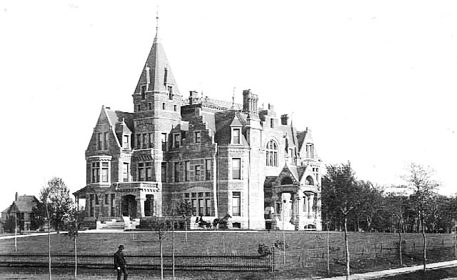
Fair Oaks, looking southeast from E. 22nd Street and Stevens Avenue, about 1886. (Minnesota Historical Society)
In the past, some writers have presumed — mistakenly — from a letter Olmsted wrote to the Minneapolis park board in 1886 — after he had passed through town on his way to California — that he was somehow responsible for Minneapolis’s system of parks. So it’s possible that others could have made the leap from the exchange of letters with McKim to the conclusion that Olmsted does proceed to design the grounds of Fair Oaks. But does he? Dr. Gregory Kaliss : “Whether he actually does or not, I have no idea.”
It is hard to prove a negative — that he did not — but consider these factors.
From all I can learn about Olmsted’s visit to Minneapolis in 1886 on his way to California, he had not been to the city before, another argument against his active participation in the detailed layout of the Fair Oaks estate.
H. W. S. Cleveland never gives a hint in his letters to Olmsted (or others) that Olmsted had ever visited Minneapolis other than the brief stop in 1886. And Cleveland was upset with park board president Charles Loring on that occasion for taking Olmsted only to see Minneapolis’s lakes and not the Mississippi River gorge, which Cleveland considered to be the “jewel” of the city. If Olmsted had spent any time in Minneapolis to work at Fair Oaks he almost certainly would have seen both the lakes and the river gorge before 1886. And if he had designed Fair Oaks landscape from afar, you’d think he would have wanted to see his work, but the newspaper account of his visit (Minneapolis Tribune, August 24, 1886) gives no indication that he visited Fair Oaks.
I don’t know how often Olmsted designed landscapes — to any “degree of detail” — without visiting them first, but his reply to the McKim letter suggests that he was not offering to design a 10-acre landscape anyway. He seems to be offering his advice on the location and situation of the house on the property — “site, aspects, entrances, approaches” — rather than the design of the whole 10 acres. Moreover, I can’t imagine Olmsted doing much more than a cursory mansion site plan for a hundred bucks. That was considerably below the going rate at the time for planning a 10-acre estate.
For a landscape architect to design a pond, stream, bridge, extensive plantings, greenhouse, stables and the rest of 10 acres without visiting the site would have required extensive correspondence with someone and that correspondence doesn’t seem to exist. And there is ample evidence (reel after reel of microfilm at the Library of Congress) that Olmsted saved just about every scrap of paper that crossed his desk.
Olmsted also makes clear by his reference to arriving at a plan “in consultation” with McKim that he would prefer to “cooperate” with McKim rather than work directly with Washburn. His return of Washburn’s notes with his letter confirms that intent.
The pond, stream and bridge that later became well-known appear in an 1890-ish photo of Fair Oaks taken from 3rd Avenue. This is the section of the park that people want to attribute to Olmsted — even though the pond ceased to exist nearly 100 years ago.

Washburn Fair Oaks from 3rd Avenue, facing west, about 1890 (Hennepin County Library, Minneapolis Collection)
A much lusher version of a pond and fountain on the estate were featured on a postcard in about 1910.
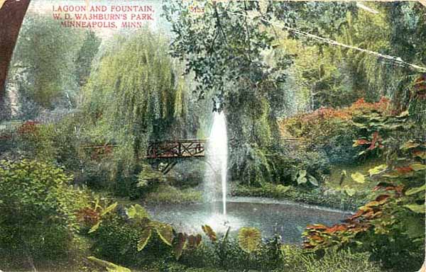
“W. D. Washburn’s Park”, meaning the grounds at Fair Oaks, looking like a tropical garden — and with a different bridge — about 1910 (Minnesota Historical Society)
Now that I’ve had a chance to see the correspondence between McKim and Olmsted, I’m more convinced that Olmsted did not design the landscape of Fair Oaks.
I’d still appreciate hearing from anyone who can make a case for Olmsted on these 10 acres. I’d also like to know more about why Washburn switched architects after McKim, Mead and White had already drawn up a plan for the house. If you know anything, we’d love to hear it.
Thanks again to Dr. Gregory Kaliss for sending copies of the letters cited here. I look forward to seeing his project in print.
David C. Smith
Postscript 6/14/2013: Thanks to an email from Andrew Caddock who was directed to a source by Kerck Kelsey, author of Prairie Lightning, a biography of William D. Washburn, we find this passage in The Northwestern Miller, (1884-1885 Holiday Number, “A Miller’s Palatial Home,” p. 82.) about Washburn’s estate: “The grounds are splendid specimens of landscape gardening from plans by Cleveland who stands at the head of the list of American specialists in this line of work. Broad winding drives and walks lead up to the front and side entrances and end at a large and handsome stable in the rear at the southwest corner of the block.” The reference is almost certainly to H. W. S. Cleveland. This is the only reference I’ve seen to Cleveland designing a private estate in Minneapolis. Thanks, Andrew.
© 2013 David C. Smith
Glenwood Spring: A Premier Park — and Water Supply?
Filed under: Minneapolis Parks: General | Tags: Bassett's Creek, Bassett's Creek Valley Park, H.W.S. Cleveland, Horace Cleveland
Comments (1) H.W.S. Cleveland, the landscape architect who created the blueprint for Minneapolis’s park system in 1883, made his first visit to Glenwood Spring near Bassett’s Creek in north Minneapolis in the spring of 1888. In a letter to the Minneapolis Tribune, published April 22, 1888. Cleveland described that visit.
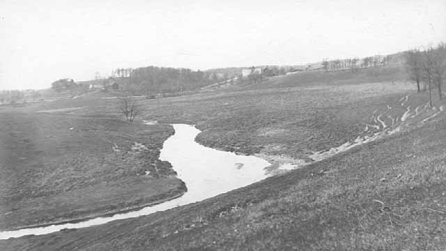
Bassett’s Creek in the vicinity of Glenwood Spring, about 1910 according to the Minnesota Historical Society. I’m not familiar enough with the lay of the land in the area to guess the exact location of this scene, but I was struck by how open the landscape was, especially given Horace Cleveland’s description of “large bodies of very fine native trees” in the vicinity of the spring. Perhaps those groves were behind the photographer. (Minnesota Historical Society)
Cleveland’s letter addressed the subject of the city’s water supply, noting that when he and his family moved to Minneapolis from Chicago in 1886 they experienced deleterious health effects — “winter cholera,” as he put it — that they thought might be associated with Minneapolis tap water. He reported that after they began using Glenwood spring water his family had no further health issues and they also found the spring water more “palatable” than the city water, which was taken from the Mississippi. Cleveland wrote that he had used the spring water for more than a year before he visited the neighborhood of the springs. When he finally did visit,
“I was not alone surprised and delighted by the beauty of the springs themselves, and their topographical surroundings, but amazed and grieved that my attention had not been called to the locality when I first came by invitation of the park commissioners, five years previous, to study the possibilities of park improvements.”
Cleveland claimed that because he was put in charge of an engineer, Frank Nutter, who, he was told, was familiar with all the sites desirable for park purposes, he didn’t feel it necessary to look at areas he was not shown. Cleveland didn’t believe he was deceived or misled, but…
“An hour’s inspection of the area in the neighborhood of these springs satisfied me that no place in the neighborhood of the city, except the vicinity of Minnehaha falls, was so well adapted by nature for the construction of a park, comprising rarely attractive topographical features — while the distance from the center of business was less than half that to Minnehaha, and the apparently unlimited capacity of the springs, which gushed from the hillsides at various points over a widely extended area, seemed to offer every possible opportunity for the ornamental use of water.”
The prospect of bubbling springs of clear water and “hills and valleys of graceful form” that wouldn’t have needed “heavy expense in grading” to be transformed into parkland appealed to Cleveland’s aesthetic sense. He also asked “whether it is worth our while to ascertain the character and capacity of the springs” to supply the entire city with water. Cleveland suggested that if the springs were capable of meeting the city’s water needs, “the city should secure them, and enough land around them to preserve them from contamination, and then enclose the area as an ornamental reservoir as had been done in Philadelphia, New York and Boston.

This photo of the ice house at Inglewood spring was taken in the mid-1890s. (Minnesota Historical Society)
What Cleveland didn’t know at the time was that the Glenwood and Inglewood springs may not have been well-known in 1883, when Nutter hosted Cleveland’s park exploration visit. Most accounts I can find of Glenwood Spring’s history claim it was discovered by William Fruen in 1884, a year after Cleveland wrote his “Suggestions for a System of Parks for the City of Minneapolis.” One account suggests Fruen found the springs in 1882. Some accounts have him discovering Glenwood Spring when building a mill on Bassett’s Creek, others when he was digging a fish pond. The latter tale, probably a tall one, was disseminated on the cached web site of the Glenwood Inglewood Water Company.
Fruen’s history with the spring includes filing the first vending machine patent in U. S. history. He invented a coin-operated machine in 1884 to dispense his spring water by the glass. Fruen also attempted to distribute his water by pipeline as Cleveland thought might be desirable. John West, owner of the posh West Hotel in Minneapolis, Thomas Lowry and Fruen wanted to build a two-mile pipeline from the spring to the West Hotel, and also sought permission to pipe the water into homes and restaurants along the way. That plan was vetoed in 1885 by Mayor George Pillsbury.

The Glenwood-Inglewood Company, 1910. The Glenwood and Inglewood springs were on adjacent property and run as separate water companies until about 1896. Until then, they were competitors. See below. (Minnesota Historical Society)
In the spring of 1885, Fruen published ads in the Tribune touting the purity of water from Glenwood Spring. He published a chemical analysis of the water conducted by Professor James Dodge of the University of Minnesota, who attested, “This water is extremely pure, being almost entirely free from organic matter.”
The ad invited readers to, “Drive out and see as fine a spring as you ever looked upon.” Another admonition in the copy is particularly interesting given the long association in later years of the Glenwood and Inglewood springs:
“Do not confound this spring with the Inglewood. Ours is the Glenwood.”
William Fruen’s son, Arthur, donated 13 acres of land along Bassett’s Creek to the park board in 1930, which was the beginning of Bassett’s Creek Valley Park. Arthur Fruen was a city council member at the time and an ex-officio member of the park board. I don’t know if that 13 acres included the site of the original spring—in other words, if Cleveland’s vision of a park that included the spring was partially realized nearly 50 years after he first saw it.
David C. Smith
© David C. Smith
H.W.S. Cleveland and Lake Harriet
Filed under: Lake Harriet, Landscape Architects, Minneapolis parks | Tags: H.W.S. Cleveland, Horace Cleveland, Lake Harriet
Leave a comment While looking for other things I keep encountering bits of information that deepen my understanding of and appreciation for Horace W. S. Cleveland’s profound contribution to Minneapolis parks.
More than a year before the creation of the Minneapolis park board and Cleveland’s “Suggestions for a System of Parks for the City of Minneapolis” a Minneapolis Tribune editorial, published January 22, 1882, announced “A Prospective Park.” The editorial noted that Philo Remington and Col. Innes, who ran the Minneapolis Lyndale Motor Line, were planning to lay out a park on the shores of Lake Harriet and “may eventually” donate it to the city. The newspaper had high praise for the property.
“It is a natural forest, with hill and dale, and comprises without exception one of the most beautiful bits of woodland scenery that can be found anywhere.”
But it was the following sentence that caught my attention and provided more insight into Cleveland’s influence in the city before the park board.
“Col. Innes has made arrangements with Mr. Cleveland, the celebrated landscape gardener, who laid out Union Park, Chicago, whereby that gentleman will take immediate charge of the work of superintending the laying out of a park that will not only be a credit to the city but an inestimable benefit to our citizens.”
I have found no evidence in Cleveland’s correspondence that he was actually hired for any work at Lake Harriet; he never mentions it. And who knows, Remington and Innes may have been blowing smoke. They had other grand plans that didn’t materialize. But whether they were serious or not about a park at Lake Harriet, the editorial indicates the high regard in which Cleveland was held in the city and the likelihood that, at the very least, he was already being consulted on park matters, especially around the lakes, before the park board existed.
A bit prematurely the Tribune enthused, “Minneapolitans may now congratulate themselves on the fact that a public park, the need of which has so long been felt, will soon be completed for their pleasure and benefit.”
Only a year later, at the next session of the legislature, a bill was passed that created the Minneapolis Board of Park Commissioners. Although Cleveland was never credited with designing any of the parks at Lake Harriet, he likely had considerable influence on how the lake shore was perceived and, later, developed.
Just another small piece of evidence of Cleveland’s immense influence on the Minneapolis park system. And yet his name does not appear on a Minneapolis park property.
David C. Smith
For more on Col. Innes’s plans for Lake Calhoun and Lake Harriet see this entry.
For more on why Cleveland’s name should be connected to the vast park that is the Mississippi River Gorge see this entry and this one, too.
For more on Cleveland in general, search above for his name or click on his name in the tag cloud at right. I’ve written quite a bit about him. Take a closer look at the map from his “Suggestions…” at right, too.
Cleveland’s Van Cleve: A Playground or a Pond
Filed under: Landscape Architects, Minneapolis parks | Tags: H.W.S. Cleveland, Horace Cleveland, Jackson Square, Theodore Wirth, Van Cleve Park
Comments (6) A tantalizing paragraph.
“Professor Cleveland submitted a plan of the improvement of the 2nd Ward Park, whereupon Commissioner Folwell moved that that part of the park designated as a play ground be changed to a pond and that so changed the plan be approved.”
“2nd Ward Park” was later named Van Cleve Park. It was the first park in southeast Minneapolis, not far from the University of Minnesota. I find it odd that the park board would create a pond in a city full of lakes, streams and rivers, but more significant, and unexpected, is what the pond replaced in the plan. A playground. Huh! Horace William Shaler Cleveland, often referred to in Minneapolis by the honorific “Professor,” never seemed a playground sort of guy.
The paragraph appeared in the proceedings of the Minneapolis Board of Park Commissioners from its meeting of May 19, 1890. That date is important because at that time few playgrounds existed. Anywhere.

Before Van Cleve Park was named, it was referred to as 2nd Ward Park as seen here in the 1892 Plat Book for Minneapolis. The man-made pond took the place of what would have been the first “playground” in a Minneapolis park. (C.M. Foote & Co., John R. Borchert Map Library, University of Minnesota)
Unfortunately Cleveland’s drawings for Van Cleve Park didn’t survive. Six of his other park designs—large-scale drawings—are owned by Hennepin History Museum, but the Van Cleve plan is not among them. Neither was it ever published in an annual report, as several other of his plans were. No documents explaining Cleveland’s intent with his plan have been found either, so we really don’t know what type of playground he imagined for the center of the new park. We can only guess.
The Infancy of Playgrounds
The idea of public space devoted to play was still quite new at the time—to Cleveland and to everyone else. In his most famous book, Landscape Architecture as Applied to the Wants of the West, published in 1873, Cleveland mentioned “play ground” only as something that might be desired in the back yard of a home. In his famous 1883 blueprint for Minneapolis’s park system, Suggestions for a System of Parks and Parkways for the City of Minneapolis, he doesn’t mention play or playgrounds at all. Even in the notes that accompanied his first six individual park designs in Minneapolis (unpublished) in 1883 and 1885, he never mentioned play spaces. Yet, in 1890, when he was 76 years old, Cleveland proposed to put a playground in a new park.
The idea was just being explored elsewhere then. In 1886 Boston had placed sand piles for kids play in some parks. The next year San Francisco created a formal children’s play area in Golden Gate Park. In New York, reform mayor Abram Hewitt supported a movement in 1887 to create small, city-sponsored combination parks and playgrounds, but that effort bore little fruit until a decade later. In 1889, Boston created a playstead at Franklin Park and an outdoor gymnasium on the bank of the Charles River, a collaboration of a Harvard professor and Cleveland’s friend Frederick Law Olmsted. Historian Steven A. Riess calls it the “first American effort to provide active play space for slum residents.” (See Riess’s City Games for a fascinating account of the growth of sports in American cities.)
The social reform movement, which later helped create playgrounds in many cities, was gaining steam with the publication in 1890 of Jacob Riis’s, How the Other Half Lives, a glimpse of grinding poverty in the slums of New York. That movement would have an enormous impact on cities in the early 1900s, especially Chicago, which became the playground capital of the United States, led in part by Jane Addams of Hull House settlement fame.
Even though Cleveland addressed many of his efforts in civic improvement to providing fresh air, green spaces and access to nature’s beauty for the urban poor, especially children, he seems an unlikely proponent of playgrounds in parks. Based on the bitter complaint in a letter to William Folwell, July 29, 1884, I had taken Cleveland to be opposed to any manufactured entertainments at the cost of natural beauty. He wrote from Chicago,
“There’s no controlling the objects of men’s worship or the means by which they attain them. A beautiful oak grove was sacrificed just before I left Minneapolis to make room for a baseball club.” (Folwell Papers, Minnesota Historical Society)
Yet, we have proof that Cleveland had a much more positive view of play areas for children in parks than he had of ball fields. A playground at Van Cleve Park, would have been a first in Minneapolis parks.
The Pond Instead
With the revised plan of the park approved, construction of the pond began immediately in the summer of 1890. A pond of 1.5 acres was created in the southern half of the park. The earth removed to create the pond was used to grade the rest of the park. That winter the park board had the pond cleared of snow so it could serve as a skating rink, too.

The artificial pond at Van Cleve was a popular skating rink. (Minneapolis Park and Recreation Board)
There must have been problems keeping water in the pond, because the next summer it was drained and the pond basin was lined with puddled clay. An artist’s rendering of the park in the 1891 annual report shows a fountain spraying a geyser of water in the middle of the pond. I’ve never seen a photo of such a fountain at Van Cleve, or read an account of it, but a similar fountain was built into the pond at Elliot Park, the only other pond created in a Minneapolis park, so it is possible a fountain existed. The park board erected a temporary warming house and toilet rooms for skaters on the pond beginning in the winter of 1905.
When Theodore Wirth arrived in Minneapolis as park superintendent in 1906, he placed a priority on improving Van Cleve Park as “half playground, half show park.” He recommended creating a sand bottom for the pond so it could be used as a wading pool and building a small shelter beside it that could double as a warming house for skaters.
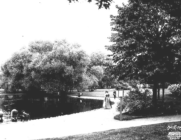
Van Cleve pond, 1905. (Sweet, Minnesota Historical Society)
The first playground equipment was installed in Van Cleve Park in 1907, following the huge popularity of the first playground equipment installed at Riverside and Logan parks in 1906.
The shelter was finally built in 1910, along with shelters at North Commons and Jackson Square. The Van Cleve shelter was designed by Minneapolis architect Cecil Bayless Chapman and was built at a total cost of just over $6,000. It included a boiler room, toilets and a large central room. The Van Cleve shelter was considerably more modest than the shelters at Jackson Square and North Commons, which cost approximately $12,000 and $16,000 respectively. On the other hand, neither of those parks had a pond. (Jackson Square actually had been a pond at one time, however, called Long John Pond. The cost of the Jackson Square shelter rose due to the need to drive pilings down 26 feet to get through the peat on which the park was built.)

The original recreation shelter at Van Cleve Park was built in 1910 facing the man-made pond. (Minneapolis Park and Recreation Board)
Wirth published a new plan for Van Cleve Park in the 1911 annual report. Although he claimed that Van Cleve demonstrated that a playground and show park could exist without “interfering” with each other, the playground occupied only a narrow strip of land between the pond and 14th Ave. SE. There were still no playing fields of any kind in the park then.
In 1917, Wirth recommended pouring a concrete bottom for the pond, really converting it into a shallow pool. Two years later the park board did pave the pond basin, but with tar macadam.

The Van Cleve shelter well after 1940 renovations, date unknown. (Minneapolis Park and Recreation Board)
Very few improvements were made at Van Cleve, or any other park in the city, for many years from the late-1920s to the late- 1940s. In 1935, in his last year as park superintendent, Wirth recommended that a swimming pool be built at Van Cleve in place of the pond, but the park board didn’t have the money for such a project during the Great Depression.
The park did get its share of WPA attention in 1940 when the federal work relief agency completed several renovations on the Van Cleve shelter to improve its capacity to host indoor recreation activities. Also included in those repairs were such basics as a concrete floor in the shelter’s boiler room. Comparing the two photos above, it’s obvious that the veranda was enclosed and the ground around the shelter was paved as well.
The man-made pond was finally filled in 1948. A modern, much smaller concrete wading pool was built to replace it the next year. The little rec shelter stood until a new community center was built at Van Cleve in 1970. By then Van Cleve, like most other neighborhood parks in the city, had been given over almost completely to active playgrounds and athletic fields.
Despite Cleveland’s aborted provision for a playground of some kind in his plan for Van Cleve Park in 1890, I imagine him astonished and a bit saddened to see neighborhood parks change so completely from the pastoral reserves and quiet gardens he had once preserved or coaxed from the urban landscapes of his time.
David C. Smith
© David C. Smith
The First River Plans: Long Before “Above the Falls” and “RiverFirst”
Filed under: Minneapolis parks, Mississippi River | Tags: Above The Falls, Charles M. Loring, H. W. S. Cleveland, Hall's Island, Horace Cleveland, Mississippi River, RiverFIRST, St.Anthony Falls, William Watts Folwell
Comments (2) 
“I have been trying hard all Winter to save the river banks and have had some of the best men for backers, but Satan has beaten us.” H. W. S. Cleveland to Frederick Law Olmsted on efforts to have the banks of the Mississippi River in Minneapolis preserved as parkland, June 13, 1889 (Letter: Olmsted Papers, Library of Congress. Photo: H. W. S. Cleveland, undated, Ramsey County Historical Society)
Considerable time, effort and expense—$1.5 million spent or contractually committed to date—have been invested in the last two years to create “RiverFirst,” a new vision and plans for park development in Minneapolis along the Mississippi River above St. Anthony Falls. That’s in addition to the old vision and plans, which were actually called “Above the Falls” and haven’t been set aside either. If you’re confused, you’re not alone.
Efforts to “improve” the banks of the Mississippi River above the falls have a long and disappointing history. Despite the impression given since the riverfront design competition was announced in 2010, the river banks above the falls—the sinew of the early Minneapolis economy—have been given considerable attention at various times over the last 150 years. There’s much more
The Preservation Instincts of Charles M. Loring
Filed under: Minneapolis parks, Minnehaha Falls | Tags: Charles M. Loring, Horace Cleveland, Minnehaha Falls
Comments (2) Charles Loring’s view on preserving natural landscapes was so well-known that this anonymous poem appeared in the St. Paul Daily Globe on September 8, 1889 in a humor column, “All of Everything: A Symposium of Gossip About Minneapolis Men and Matters.”
A grasping feature butcher,
With adamantine gall,
Wants to build a gallery
At Minnehaha’s fall.He wants to catch the people
Who come to see the falls,
And sell them Injun moccasins
And beaded overalls.He wants to take their “phizes,”
A dozen at a crack,
With the foliage around them
And the water at the back.But the shade of Hiawatha
No such sacrilege would brook:
And he’d shake the stone foundations
Ere a “picter had been took.”C. M. Loring doesn’t like it,
For he says he’d like to see
The lovely falls, the creek, the woods,
Just as they used to be.
Loring had chaired a commission appointed by the governor to acquire Minnehaha Falls as a state park in 1885. The land was finally acquired, after a long court fight over valuations, in the winter of 1889. (The total paid for the 180-plus acres was about $95,000.) See City of Parks for the story of how George Brackett and Henry Brown took extraordinary action to ensure the falls would be preserved as a park.
The poem in the Daily Globe appeared because the park board was considering permitting construction of a small building beside the falls for the express purpose of taking people’s photos with “the water at the back.” And of course charging them for the privilege.
That proposal elicited a sharp response from landscape architect H. W. S. Cleveland who also opposed having any structure marring the natural beauty of the falls. Cleveland used language much harsher than the reserved Loring likely would have used. In a letter to his friend William W. Folwell, Cleveland wrote on September 5, 1889,
I cannot be silent in view of this proposed vandalism which I am sure you cannot sanction, and which I am equally sure will forever be a stigma upon Minneapolis, and elicit the anathema of every man of sense and taste who visits the place.
If erected it will simply be pandering to the tastes of the army of boobies who think to boost themselves into notoriety by connecting their own stupid features with the representation of one of the most beautiful of God’s works.
The preservation passion of Loring and Cleveland is evident today in the public lakeshores and river banks throughout Minneapolis. The next time you take a stroll around a lake or beside the river, or fight to acquire as parks the sections of the Mississippi River banks that remain in private hands, say a little “thank you” to people like Loring and Cleveland who saw the need to acquire lakes and rivers as parks more than 125 years ago—and nearly got them all.
And the photography shack was never built.
David C. Smith
Recommended Reading from Horace W. S. Cleveland
Filed under: Landscape Architects, Minneapolis parks, Mississippi River | Tags: H.W.S. Cleveland, Horace Cleveland, Landscape Gardening
Comments (1) We haven’t had much of a winter yet in Minnesota, but it’s inevitable. When it comes and you’re imprisoned in your cozy den, your thoughts may turn to spring and the gardens you’ll plant or visit. To get you thinking about warmer weather, I’m providing a reading list from the man who envisioned Minneapolis’s park system and designed the first parks acquired by the Minneapolis park board in the 1880s.
In 1886, the secretary to the Minneapolis park board, Rufus J. Baldwin, apparently asked landscape architect Horace W. S. Cleveland to recommend books on his profession. It’s not clear if Baldwin was interested in furthering his own education (he was a prominent Minneapolis attorney) or if he was acquiring books for the park board. Below is Cleveland’s reply dated 23 Sep. 1886.
(All of the books Cleveland cited are now available free online at Google Books. The links in the letter take you to the online volume of the work cited.)
In considering your request that I would furnish you a list of desirable works on landscape gardening I find the subject growing in my mind so rapidly and attaining such dimension that the chief difficulty lies in making a judicious selection. The literature of the last century was especially rich in the discussion of the principles on which the art is founded. “Repton’s Landscape Gardening” is perhaps the ablest and most elaborate of the works of that date, but I think I learned more of first principles from the “Essays on the Picturesque, By Sir Uvedale Price,” than from any book.
It is doubtful however whether either of these books can be purchased in this country unless by chance at a second-hand store. “Loudon’s Encyclopedia of Horticulture,” contains perhaps the most detailed, practical instructions of any English work and is still a standard of reference and can be had in England though it has not been republished here.
“Downing’s Landscape Gardening” is at the head of all works on the subject in this country and is in fact a compilation and adaptation to our wants of all the essential principles of the best foreign writers. Next to that and in fact supplying much in which Downing’s work is deficient is “Country Life By Robert Morris Copeland.” He was for many years my partner and was a man of rare taste and skill, and his book is an admirable one. “Scott’s Suburban Homes,” is also an excellent treatise and full of judicious advice in regard to the arrangement of grounds and tasteful use of trees and shrubbery. These books can be procured of any of the leading booksellers or at the seed stores of the principal cities. In ordering Downing’s book, be sure to get the edition which has the appendix by Winthrop Sargent, which contains a vast amount of very valuable information.
I do not think of any other work directly devoted to the subject that would add to the value of what is contained in the above.
“The Horticulturist” during the time it was edited by Downing was rich in essays on different branches of useful ornamental gardening, but it is doubtful if a complete set could be had, and indeed the three works above enumerated comprise I think all the essential principles so far as they can be given by print and illustration.
If I think of others that would be desirable I will let you know.
The letter is signed, “Very truly yrs, H.W.S. Cleveland.”
(The original letter is in the files of the Minneapolis Park and Recreation Board at Special Collections, Minneapolis Central Library, Hennepin County Library.)
Amazing, isn’t it, that works Cleveland cited as unavailable in the United States in 1886 — or available at “the seed stores of principal cities” — are now free to anyone with access to a computer. Some people have a problem with a company such as Google having so much control over information — I just read The Googlization of Everything (And Why We Should Worry) by Siva Vaidhyanathan — and while I agree with concerns over the concentration of information control, the widespread availability of so much information, even as old and arcane as these texts, is an invaluable resource.
Happy reading.
David C. Smith
P.S. Minneapolis still doesn’t have a park named for Horace W. S. Cleveland — and we should. I’m still in favor of naming the west side of the Mississippi River Gorge for him.
The Myth of Bassett’s Creek
Filed under: Minneapolis parks, Mississippi River | Tags: Bassett's Creek, H.W.S. Cleveland, Horace Cleveland, Minnehaha Creek, Mississippi River
Comments (24) I heard again recently the old complaint that north Minneapolis would be a different place if Bassett’s Creek had gotten the same treatment as Minnehaha Creek. Another story of neglect. Another myth.
You can find extensive information on the history of Bassett’s Creek online: a thorough account of the archeology of the area surrounding Bassett’s Creek near the Mississippi River by Scott Anfinson at From Site to Story — must reading for anyone who has even a passing interest in Mississippi River history; a more recent account of the region in a very good article by Meleah Maynard in City Pages in 2000; and, the creek’s greatest advocate, Dave Stack, provides info on the creek at the Friends of Bassett Creek , as well as updates on a Yahoo group site. Follow the links from the “Friends” site for more detailed information from the city and other sources.
What none of those provided to my satisfaction, however, was perspective on Bassett’s Creek itself after European settlement. A search of Minneapolis Tribune articles and Minneapolis City Council Proceedings, added to other sources, provides a clearer picture of the degree of degradation of Bassett’s Creek — mostly in the context of discussions of the city’s water supply. This was several years before the creation of the Minneapolis Board of Park Commissioners in 1883 — a time when Minnehaha Creek was still two miles outside of Minneapolis city limits. The region around the mouth of Bassett’s Creek was an economic powerhouse and an environmental disaster at a very early date — a mix that has never worked well for park acquisition and development.

Idyllic Minnehaha Creek, still in rural surroundings around 1900, quite a different setting than Bassett’s Creek, which had already been partly covered over by then. (Minnesota Historical Society)
“A Lady Precipitated from Bassett’s Creek Bridge”
Anfinson provides many details of the industrial development of the area around the mouth of Bassett’s Creek from shortly after Joel Bean Bassett built his first farm at the junction of the river and the creek in 1852. By the time the Minneapolis Tribune came into existence in 1867, industry was already well established near the banks of the creek. A June 1867 article relates how the three-story North Star Shingle Mill had been erected earlier that year near the creek. The next March an article related the decision to build a new steam-powered linseed oil plant near the creek on Washington Avenue.
Even more informative is a June 27, 1868 story about an elderly woman who fell from a wagon off the First Street bridge over the creek. “A Lady Precipitated from Bassett’s Creek Bridge, a Distance of Thirty Feet,” was the actual headline. (I’m a little embarrassed that I laughed at the odd headline, which evoked an image of old ladies raining down on the city; sadly, her injuries were feared to be fatal.) But a bridge height of thirty feet? That’s no piddling creek — even if a headline writer may have exaggerated a bit. The article was written from the perspective that the bridge was worn out and dangerous and should have been replaced when the city council had considered the matter a year earlier. Continue reading

