Archive for the ‘Minneapolis parks’ Category
Yes, there was a Clarence Triangle.
Filed under: Minneapolis Park Memory, Minneapolis parks | Tags: Clarence Triangle
 Leave a comment
 I just received this note from a reader who remembers Clarence Triangle in Prospect Park, which I wrote about recently. Thanks for the story.
Oh, there was a triangle there! I lived at 79 Bedford, across the street from the Triangle, at the foot of the hill that is Clarence. My parents bought the house in 1948, and sold it in 1975. Some time later, Dutch elm took most of the trees on Bedford, and they took out the curve at Bedford and Orlin (NOT an improvement in my opinion). I suspect when they modified the street, that is when they took out the triangle. I am guessing the late 1980’s?
It was a wonderful neighborhood to grow up in! As kids, we’d look out our living room window when it snowed, and watch the cars try to make it up the Clarence hill. They usually would, unless they met a car going downhill that would not move aside :) Cars were rear wheel drive then.
Lloyd Mann
Large Stone Fireplace in Minnehaha Dog Park?
Filed under: Minneapolis parks, Minnehaha Falls | Tags: Minnehaha Dog Park, Minnehaha Falls
Comments (7) Mary MacDonald recently wrote to ask for info on the large stone fireplace near the long path to the Mississippi River in the Minnehaha Dog Park off 54th and Hiawatha. She said she’s been unable to find any info on who built it and how old it is. Does anyone know? I don’t know anything about it. Leave a comment or e-mail me at the address below.
David C. Smith
Maybe it’s time for Puck to have a sniff.

Puck
Linking the Lakes: Making Minneapolis the Venice of North America
Filed under: Minneapolis parks | Tags: Lake Calhoun, Lake of the Isles
Leave a comment Happy Belated Centennial! Yesterday was the hundredth birthday of the channel that links Lake of the Isles with Lake Calhoun. It was the first of the navigable lake connections that later extended to Cedar Lake and Brownie Lake. Some background on those lake connections was featured in an earlier post on Lake Calhoun and Lake Harriet.
The “Linking of the Lakes” was turned into a civic celebration that lasted nearly a week. The event was conceived and planned by the Minneapolis Publicity Club. The idea for a civic celebration was apparently hatched in November 1910 at the Minneapolis Harvest Dinner, a more modest one-evening event. While the central event of the civic celebration was the linking of the lakes, it appears to have been pretense for a party.
“It is argued by the business men that in no better way can the city merchant get in more personal touch with his country customers than through the Civic celebration when, under the spirit of merrymaking and jollity, they come together.”
Minneapolis Morning Tribune, July 2, 1911
The park board knew exactly what the intent was when it passed a resolution on December 5, 1910 that “irrespective of the benefits which may accrue to the city through such a celebration, the occasion is of such peculiar interest and significance to this board, that every effort should be made to do its full part…”
The construction of a channel between Lake Calhoun and Lake of the Isles was not a particularly challenging or imaginative endeavor. As noted in the earlier post, the project had been considered for many years and treated as a done deal as early as 1899 by landscape architect Warren Manning in his recommendations for the Minneapolis park system. In engineering terms it was simpler than the dredging that had been going on for years at Lake of the Isles, both in the 1880s and 1900s. The only construction needed for the project were bridges over the excavated channel, which were not more challenging to plan and build than bridges elsewhere in the city — although the park board’s 1909 annual report included the admission that bridge construction estimates were 50 to 100 percent over budget.
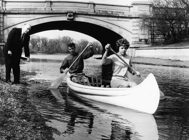
Park superintendent Howard Moore helps launch a canoe in 1960 to celebrate navigable water once again after a few years of a dry channel between Lake of the Isles and Lake Calhoun. (Minneapolis Park and Recreation Board)
Even the design competition for bridges, with a top prize of $800, had been disappointing. Park Superintendent Theodore Wirth wrote in the 1909 annual report, “With a few exceptions the designs submitted were not of the high-class character which it was thought the competition would bring forth.” The third prize was not even awarded. To make matters worse, the bridge over the channel from Lake of the Isles to Cedar Lake had to be partially torn down and rebuilt because it began to settle as soon as it was built, which delayed the connection of Isles and Cedar.
The connection of Lake of the Isles to Cedar Lake was finally completed in 1913, and Cedar Lake was linked to Brownie Lake in 1917. That final connection made possible a new feat of municipal athletic endurance: the swimming of the Chain of Lakes. The Minneapolis Morning Tribune, August 8, 1918 reported the setting of a new record when Dan Bessessen, the new captain of the University of Minnesota swim team and a life guard at Lake Calhoun, swam from the north end of Brownie Lake (off Superior Avenue then) to Thomas Avenue on the southern shore of Lake Calhoun in one hour and thirty-eight minutes. The swim was supervised by Frank Berry, the park board’s recreation director, who accompanied Bessessen in a boat that also carried four time keepers.
Despite the $125,000 price tag to link Isles and Calhoun, the park board appeared not to be profligate with funds. When Wirth submitted plans and an estimate for a park board float for the water parade during the celebration, it was defeated by a vote of 10-1 even though the City of Minneapolis was spending $500 for a float. Another request from Wirth to spend $200 to buy evergreen trees to temporarily cover the “unsightly” railroad embankment adjacent to the lagoon during the celebration was defeated by a vote of 11-0.
I think it’s debatable if the “Linking of the Lakes” was even the park board’s biggest role in municipal or state history in the spring and summer of 1911. I’d give top billing to another event that the park board didn’t initiate, but went along with: the donation to the park board by Clinton Morrison of the land for an art museum. The result of that transaction was the eventual construction of the Minneapolis Institute of Arts in Dorilus Morrison Park.
I love the channels that connect the lakes, which Jesse Northrop said would make Minneapolis the “Venice of North America,” but I think the construction of what has become an excellent art museum, while it might not make Minneapolis the “Florence of North America,” is still of greater importance to our city today. Even without the channels between lakes Minneapolis was still blessed with exceptional natural attributes. The art museum filled an otherwise unmet need at the time, despite Thomas Barlow Walker’s incredible art collection.
David C. Smith
Prospect Park Garden Club wins Triangle Award; Orlin Triangle is smallest park.
Filed under: Bryn Mawr, Minneapolis parks, Prospect Park | Tags: Bryn Mawr, Elmwood Triangle, Laurel Triangle, Orlin Triangle, Prospect Park, Rollins Triangle
Comments (1) An update on the smallest park triangles:
The beautiful triangles in Prospect Park are maintained by the Prospect Park Garden Club. I learned that in the delightful backyard of Mary Alice Kopf last Saturday during the Annual Garden Walk and Plant Sale sponsored by the Prospect Park Garden Club. Nobody I talked to in Prospect Park knew, however, why some triangles were taken over by the park board and others weren’t. So if you know…
I am certain now that Orlin Triangle is the smallest of the street triangles in the Minneapolis park system.

Orlin Triangle in Prospect Park is the smallest park in Minneapolis.
The second smallest is Elmwood Triangle at Luverne and Elmwood just north of Minnehaha Creek near Nicollet. Basic grass and tree — and two dead end signs. Seems a bit ominous.
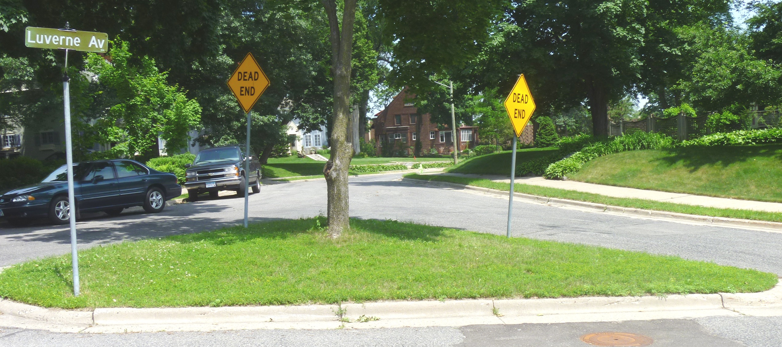
Elmwood Triangle, the second smallest park in Minneapolis, listed at 0.01 acre. Based on my rough measurements, bigger than Orlin Triangle.
The most attractive triangle park outside of Prospect Park is Laurel Triangle in Bryn Mawr. My next task is to find out who takes care of this park. Laurel Triangle was purchased by the park board for $700, most of which went to pay back taxes, in 1911, so it’s a little older park officially than the Prospect Park triangles.

Laurel Triangle, at Laurel and Cedar Lake Road, is beautiful too, in a wilder way than the Prospect Park triangles. So big it has two sidewalks and two stop signs. There’s a little stone bench next to the tree that I’d love to sit on with a cup of coffee.
Another of the smallest triangles is Rollins Triangle at Minnehaha and E. 33rd St. across from Peace Coffee. Quite a different environment on a busy thoroughfare and considerably larger than the smallest. Farther south, Adams Triangle on Minnehaha and 42nd, is one-third-acre, one of the larger triangles.

Rollins Triangle has a newspaper stand, a bus bench, vent pipes and a bit of a garden that’s overgrown. Definitely larger.
Most triangles are named for streets, but Rollins was named for the real estate development, Rollins Addition, in the neighborhood. It was taken over by the park board at the request of the city council in 1929 and officially named in 1931.
Someday soon I’ll visit the two remaining triangles listed at 0.01 acre in the park board’s inventory, Sibley and Oak Crest in northeast Minneapolis. But judging by their images on Google maps they are both larger than triangles shown here.
I purchased several plants for my yard at the Prospect Park Garden Sale at Pratt School. This whole business of planting triangles inspired me. And that was one objective of early park planners — to encourage us to replicate the pretty little public gardens on our own property.
David C. Smith
Lost Minneapolis Parks: A Fifth Prospect Park Triangle
Filed under: Lost Minneapolis Parks, Minneapolis parks | Tags: Midway Triangle, Prospect Park, Tower Hill Park, Witch's Hat
Comments (1) A fifth Prospect Park triangle was added to Minneapolis parks inventory in 1919 when the City Council turned over a 0.03-acre triangle at the intersection of Bedford Street and University Avenue S.E. The Minneapolis Board of Park Commissioners (BPC) instructed the superintendent to plant shrubbery on the triangle and to maintain it. It was named Midway Triangle. The City Council must have forgotten that it gave the land to the BPC—or ignored the fact—because in November 1944 the BPC adopted a resolution that “inasmuch as the intersection of University Avenue and Bedford Street, including what was formerly Midway Triangle, has been paved,” it was turning over the land to the City Council. There is still a remnant of the triangle at the intersection, just enough curbed space to hold a traffic signal, a light post and some signs.
The entire neighborhood might have looked quite different if the Minneapolis park board had acted on John Pillsbury’s proposal in 1887. Pillsbury was the former Governor of Minnesota and former Minneapolis park commissioner and still the president of the University of Minnesota’s Board of Regents at the time, who had just donated a $150,000 building to the University. He proposed that University Avenue be made a parkway from Central Ave. to the county line (the boundary with St Paul) and that from Oak Street east the parkway be 120 feet wide, or more than 50% wider than it is now.
That might have been spectacular, but it is also possible that a parkway on University Avenue would have suffered the same fate as early parkways on Hennepin Avenue from Loring Park to Lakewood Cemetery and Lyndale Avenue North from Loring Park to Farview Park. They were eventually abandoned by the BPC as parkways and returned to the control of the City of Minneapolis, because they carried too much traffic to be true parkways. I suspect the same would have happened to a parkway on University Avenue; it was a major thoroughfare. But it’s fun to speculate and try to picture a beautiful wide boulevard approaching the University of Minnesota from the east—in the shadow of Tower Hill.
David C. Smith
Where is De Soto Harbor?
Filed under: Minneapolis parks, Mississippi River | Tags: De Soto Harbor, Ford Dam, Mississippi River, Stone Arch Bridge
Comments (5) With the completion of the High Dam, now the Ford Dam, on the Mississippi River just upstream from Minnehaha Creek in 1917, the Minneapolis park board was pressed to name the new reservoir that formed behind the dam. Without explanation, it settled on the odd name of “De Soto Harbor” on July 3, 1918. I have found no evidence that the name was ever changed, rescinded — or used.

The “High Dam” nearing completion in 1917. It became known as the Ford Dam in 1923. This was before the Ford Bridge was built later in the 1920s. (from City of Parks, Minnesota Historical Society)
The harbor was named for Hernando de Soto, the Spanish explorer who was believed then to have been the first European to see the Mississippi River about 1540. De Soto’s expedition never got anywhere near Minnesota, however, crossing the Mississippi near Memphis, Tennessee. De Soto’s story is one of some “firsts” in European exploration of North America, but also considerable brutality toward native people.
Other names the park board considered for the reservoir were Lafayette Lake, Liberty Lake, Lake Minneapolis and St. Anthony Harbor. (Minneapolis Tribune, June 27, 1918.)
The name chosen was unusual because the park board had not, for the most part, named park properties for people not connected with the history of the city or state. (Logan Park was a notable exception.) The decision to name parks only for people of local historical significance was adopted as an official policy of the park board in 1932. The policy was revised in 1968 to enable Nicollet Park to be renamed Dr. Martin Luther King Park.
Of course, some park features on the Minneapolis map—such as St. Anthony Falls, Lake Harriet, Lake Calhoun, Minnehaha Creek—predate by decades the creation of the park board in 1883.
The park board had been involved in issues surrounding dam construction for years by the time it named the reservoir, first with the Meeker Island Dam and later the “High Dam.” From as early as 1909 the park board had sent representatitives to meetings on high dam construction held by the US Army Corps of Engineers and in 1910 had requested that the park board receive half the electricity generated by the dam in exchange for “flowage rights” over land the park board owned. The government did not agree, even though the park board lost 27 acres of land for the reservoir in 1916. Included in that acreage were several islands in the river. The park board granted rights to cut down timber on one island in the river to a local charity before the trees were submerged. The board noted that neither the park board nor the Corps of Engineers wanted a stand of dead timber in the middle of the new reservoir.
Few photos I have seen give a good picture of water levels in the Mississippi before the dams were built. One of the most dramatic is this one of the Stone Arch Bridge in 1890.

Stone Arch Bridge 1890, before any dams downstream created reservoirs. (Minnesota Historical Society)
I don’t know what month the photo was taken, although foliage says summer. Perhaps the river was unusually low in late summer, but to see the Stone Arch Bridge nearly completely out of the water is unusual.
David C. Smith
You Think a Dog Park Was Controversial?
Filed under: Minneapolis parks | Tags: Dr. Martin Luther King Park, Dr. Strangelove, Nicollet Park, The Parade
Comments (1) After holding public hearings and receiving “various communications objecting to it,” on April 20, 1960, the Minneapolis park board rescinded an agreement with Minneapolis Civil Defense to build a “demonstration atomic bomb fallout protective shelter” in Nicollet Park. The board granted permission to build the demonstration fallout shelter at The Parade instead. Was it ever built? I don’t know.

This 1960 instructional booklet included plans for a fallout shelter, presumably similar to the one Minneapolis Civil Defense wanted to build at The Parade. This image is from authentichistory.com. The booklet is also available for sale on e-Bay at the time of this posting–if you’re still worried, or think it would do any good.
In 1968 Nicollet Park was renamed Dr. Martin Luther King Park. The park was the focus of bitter debate over the past year. The issue was whether converting a small portion of the park into an off-leash dog park would desecrate the memory of Dr. King. The dog park was not built.
During the 1960 meeting at which the board approved the fallout shelter, it also granted permission to the Twin City Walk for Peace Committee to hold an open air meeting at The Parade at the conclusion of a “peace walk.”
As a point of reference, Stanley Kubrick’s classic film of the atomic-bomb age, Dr. Strangelove, was released in 1964.

David C. Smith
Minneapolis Park Crumbs I: Morsels Left Behind from Park Research
Filed under: Minneapolis parks, Mississippi River | Tags: Lake Calhoun, Minnehaha Park, Mississippi River
Comments (2) Outlawed: The possession or sale of heroin, other opium derivates, and cocaine without a prescription. Penalties established of $50-$100 fine or 30-90 days in the workhouse. Minneapolis City Council Proceedings, October 10, 1913.
Approved: Spanish language classes for Central and West high schools. Existing faculty at each school will teach the classes. Action of the Minneapolis School Board reported in the Minneapolis Tribune, January 13, 1915.
Suggested: A cement wall between Lake Calhoun and Lakewood Cemetery if the city would continue to permit ice to be cut from the lake. From Minneapolis Journal article, June 8, 1901, about the visit to Minneapolis of Dr. Henry Marcy, “the eminent surgeon and philanthropist of Boston.” Dr. Marcy made the suggestion when he visited Lake Calhoun with Charles Loring. He said he had heard a great deal about Minneapolis’s parks and had a Minneapolis map on which he had sketched out their locations, but wanted to see them.
Found: Gold in Hennepin County, the best sample near Minnehaha Park. The specimen recovered by Prof. J. H. Breese, a former professor at Eastern universities, was confirmed as gold by state geologist Prof. N. H. Winchell. Prof. Breese believes the particles were carried from higher latitudes during the drift period, “but he is quite confident that all has not yet been found.” Reported by Minneapolis Tribune, July 17, 1889.
Built: A 100-foot steamboat named “Minneapolis” by Hobart, Hall and Company. Will begin running freight between Minneapolis and St. Cloud in late July. The company asked the Board of Trade for a free landing near Bassett’s Creek. Reported by Minneapolis Tribune July 8, 1873. The company planned to build another steamboat for the same route, more if “expedient.”
David C. Smith
Phelps Wyman: Pioneer Landscape Architect and Minneapolis Park Commissioner
Filed under: Landscape Architects, Minneapolis parks | Tags: Minnehaha Creek, Mt. Curve Triangle, Phelps Wyman, Thomas Lowry Park, Virginia Triangle, Washburn Fair Oaks
Comments (6) Several pioneer landscape architects were associated with Minneapolis parks, from H. W. S. Cleveland, in a very big way, to Warren H. Manning, more modestly, to Frederick Law Olmsted, who once wrote a letter to Minneapolis park commissioners at Cleveland’s request. But only one pioneer landscape architect was also elected to the Minneapolis Board of Park Commissioners: Phelps Wyman. (He never used his first name, Alanson, so I won’t either.) Wyman’s pioneer status in landscape architecture was determined by Charles A. Birnbaum and Robin Karson in Pioneers of American Landscape Design, which profiles about 150 American landscape architects.
Wyman is also one of a very few landscape architects not employed by the Minneapolis park board to have had designs for Minneapolis parks published in annual reports of the park board. The 1922 annual report presented Wyman’s plan for Douglas Triangle, now Thomas Lowry Park, which I wrote about here. This plan was executed in 1923. Curiously, I can find no record that Wyman was paid for the work.

Wyman’s plan for pools and pergola in 1922 annual report of the Minneapolis Board of Park Commissioners
The next year he had another interesting plan published in the park board’s annual report, but it was never implemented. Wyman’s plan for Washburn Fair Oaks Park across from the Minneapolis Institute of Arts (MIA) Continue reading
Horace Cleveland Hated Rectangles
Filed under: Landscape Architects, Minneapolis parks | Tags: Forest Heights, Glen Gale, H.W.S. Cleveland, Horace Cleveland, Oak Lake, Samuel Gale
Comments (2) Oak Lake Addition was a rare real estate development in Minneapolis because the streets followed the contour of the land instead of a grid pattern. While I’ve found no evidence of who was responsible for the layout of the addition in 1873, it is reminiscent of Horace Cleveland’s work in St. Anthony Park for William Marshall at about the same time and later in Washburn Park or Tangletown near Minnehaha Creek. Although I find no reference to the project in Cleveland’s correspondence, it is plausible that he was involved in the layout of Oak Lake Addition.

Oak Lake Addition, platted in 1873. 1892 plat map (John R. Borchert Map Library, University of Minnesota)
Samuel Gale, the man who platted the Oak Lake Addition, had his hands in nearly everything in the young city: School Board, Athenaeum and Library Board, Academy of Natural Sciences, Society of Fine Arts, Board of Trade, City Council, the public lecture series, he even sang in the city’s most celebrated quartet along with his brother, Harlow, and it was later claimed that although nearly everyone speculated in real estate in those days, he was the dean of realtors in the city. Given his wide interests and involvement in civic affairs, it would be incredible if Gale hadn’t been one of those who welcomed Horace Cleveland to the city during his first visits in 1872.
In July, 1873 Gale was the chair of the Board of Trade’s committee on parks, which reported that several “public-spirited citizens” planned to devote considerable time to the issue of parks with “Mr. Cleveland, well-known landscape gardener” before the next Board of Trade meeting. (Minneapolis Tribune, July 18, 1873.) I think it is safe to assume that Gale himself was one of those who planned to meet with Cleveland. So it appears almost certain that Gale and Cleveland knew each other and had likely discussed park issues before Gale produced his plat for the Oak Lake Addition.
Absent information on who designed Oak Lake Addition, it’s fun to speculate that Cleveland may have had a hand in it, or at least influenced it through the book he published in early 1873, Landscape Architecture as Applied to the Wants of the West. In his classic of landscape architecture, Cleveland expressed his distaste for the grid pattern of streets in so many cities, because it ignored “sanitary, economic and esthetic sense.”
“Every Western traveller is familiar with the monotonous character of towns resulting from the endless repetition of the dreary uniformity of rectangles,” he wrote.
While he singled out western cities — it was his book’s theme — it takes only a glimpse of a map of Manhattan to know that rectangularism was not a sin peculiar to the frontier. For New York, however, it was already too late to do anything about that “dreary uniformity”; the West still had a chance to get it right. Cleveland added that “even when the site is level” the rectangular fashion of laying out cities “is on many accounts objectionable.”
He suggested that if blocks had to be rectangular at least they should be Continue reading
Lost Minneapolis Parks: Oak Lake, Two Ovals and Two Triangles
Filed under: Lost Minneapolis Parks, Minneapolis parks | Tags: H.W.S. Cleveland, Horace Cleveland, Loring Park, Oak Lake, Samuel Gale
Comments (14) Another convergence: the season of farmers’ markets is upon us and so is a decision on whether the Minnesota Vikings get a new tax-supported stadium. The site favored for a stadium by some Hennepin County commissioners is the Minneapolis Farmers’ Market on Lyndale Avenue just west of downtown and Target Field.
You’d never know by looking at it today, but the site is rich in history. The current market sits in the middle of what was once Oak Lake, one of the attractions of a semi-exclusive and progressive residential neighborhood late in the 19th Century. It was Minneapolis’s second-oldest park. A bandstand near the lake was built in 1881 to host some of the earliest outdoor concerts in the city. The gracefully curved streets of the neighborhood filled with the carriages of wealthier concert goers, while residents of the neighborhood and music lovers without carriages sat on the sloping hillside in what was called a natural amphitheater near the lake.
Oak Lake Addition, platted in 1873. 1892 plat map (John R. Borchert Map Library, University of Minnesota)
Some people say the Oak Lake Addition experienced gentile flight, then white flight, as the neighborhood went from mostly white Protestant to Jewish to black before it finally gave way to industrial and market uses. And it happened fast. But the trendy little neighborhood was probably doomed by something much more benign than ethnic, religious or racial bigotry; the creation of the Minneapolis Board of Park Commissioners helped kill the Oak Lake Addition.
More on Murphy Square and Augsburg College — and more praise for the Minnesota Historical Society.
Filed under: Minneapolis parks | Tags: Augsburg College, Carl Chrislock, Murphy Square
Leave a comment In response to my request for info on Murphy Square before the freeway, Juventino Meza, a student at Augsburg College, reports that two books provide stories and photos of the Augsburg campus and the neighborhood before the 1960s. He writes that From Fjord to Freeway: 100 Years of Augsburg College, by Carl H. Chrislock, is available at the Augsburg library. He also recommends From Immigrant Parish to Inner-city Ministry: Trinity Lutheran Congregation 1868-1998, by James S. Hamre. The Trinity Lutheran Church building, once located south of Murphy Square and the Augsburg campus, was taken out by the freeway. The latter book is available from Trinity Lutheran Congregation, which still exists and has an office at 2001 Riverside Avenue and a website here.
I have written often of the amazing resource this state maintains in the Minnesota Historical Society. More than once I have noted that regardless of subject, I always check to see if the Visual Resources Database at MHS has a photo. While looking for photos of Augsburg College and Murphy Square I was astonished to find a photo of Augsburg history professor Carl H. Chrislock, author of the Augsburg history Mr. Meza recommended. Here’s proof.
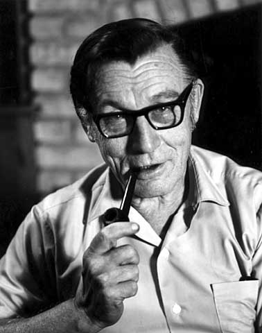
Carl H. Chrislock, professor emeritus, Augsburg College, 1970 (Alan Ominsky, Minnesota Historical Society)
Thanks to Mr. Meza——and to Minnesota legislators for the Minnesota Historical Society. It’s probably a good idea to remind your legislators that the Minnesota Historical Society needs their support.
David C. Smith