Friday Photo: How A Stone Arch Was Made
Filed under: Minneapolis parks, Mississippi River | Tags: Father Hennepin Bluffs, Mill Ruins Park, Stone Arch Bridge
 Comments (5)
 The Stone Arch Bridge over the Mississippi River in downtown Minneapolis is becoming one of the iconic images of the city. Have you ever wondered how those arches were made? I have. So I found this photo of the bridge under construction. The deck of the bridge is maintained by the Minneapolis Park and Recreation Board, so let’s call it a park. Day and night the bridge provides the best views of the city. A hike over the bridge between Mill Ruins and Father Hennepin Bluffs, in either direction, is a must for visitors and residents.
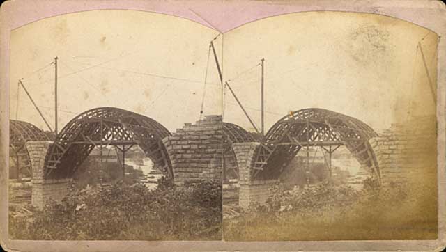
This stereoscope image shows the stone arches being built over forms in 1883. (Henry Farr, Minnesota Historical Society)
The two-track railroad bridge was being built at the time the park board was created in 1883.

The Stone Arch Bridge being completed in 1883. (Burlington Northern, Minnesota Historical Society)
This is another favorite shot of the bridge as it neared completion
David C. Smith
A Racetrack Before It Became a Park — and an Airport
Filed under: Minneapolis Airport, Minneapolis parks | Tags: Eddie Rickenbacker, Metropolitan Airport Commission, Snelling Speedway, Twin City Motor Speedway, Wold Chamberlain Field
Comments (8) Not many people would recognize this Minneapolis park property, which lies outside city limits and was acquired in 1928, twelve years after this photo was taken. There is some uncertainty about how much of this property is still technically owned by the Minneapolis Park and Recreation Board, but the property is administered by another agency.

Four-wide racing at the Snelling Speedway, 1916. (Minneapolis Park and Recreation Board.)
This is the famous Twin City Motor Speedway, or Snelling Speedway, in 1916, the second year of its three-year life. The speedway was named informally for its location adjacent to Fort Snelling. The infield of the two-mile concrete track was later used as a landing field for airplanes — and eventually became Minneapolis-St. Paul International Airport. The Minneapolis Board of Park Commissioners acquired the land in 1928 to develop it as an airport for the city. The task fell to the park board because it was the only agency of Minneapolis city government that could own land outside of city limits. (The law that permitted the park board to own land outside city limits was passed by the Minnesota legislature in 1885 to permit the park board to purchase land in Golden Valley for part of what eventually became Glenwood (Wirth) Park .) The park board built and ran the airport from 1928 until the Metropolitan Airports Commission was created in 1943, at which time the park board turned over administration of the airport. The park board had spent a significant percentage of its meager resources in those years developing the airport.
The enormous grandstands pictured left and center were built in 1915 to hold 100,000 people. The problem was that far, far fewer attended the few races held there. The first major race in 1915, a 500-mile race patterned after the Indianapolis 500, was widely promoted by the newspapers for weeks. The weekend of the race — the first weekend in September, just before the State Fair opened — the Minneapolis Tribune wrote that hotel rooms were impossible to find in the Twin Cities; hoteliers were referring unaccommodated visitors to private homes for a place to sleep. It was said to be the busiest weekend in the history of Minneapolis hotels with guests arriving from around the country. The Twin City Rapid Transit Company built a special spur track to the speedway to transport the crowds.
Unfortunately for the promoters, drivers, and the legions of workers who constructed the track and were not paid, attendance was much smaller than hoped. Society columns in the Tribune covered the rich and famous who attended the races and trumpeted this “innovation in divertisement” for the social elite, but the paper reported race attendance at only 28,000.
The 1915 race was a disappointment in every respect. The banked concrete track, heralded as the fastest and safest track in the world, was in fact extremely rough. The cars vibrated to pieces and the drivers didn’t fare much better. The champion Italian driver, Dario Resta, was reported to have denounced the roughness of the track “vociferously” after his first test drive during race week. If you know any Italian curse words, you could probably translate the “vociferously”. He was prescient, because his car didn’t survive much more than 100 miles on race day. But potential race fans didn’t know that ahead of time.
Neither could they have imagined the snoozefest that the race became. It only takes a glance at the race results to understand how tedious the day must have been for spectators. With only twenty cars starting the race and most of them falling apart or dropping out for mechanical reasons early on — having a “mechanician” riding along, the second person visible in the cars, didn’t prevent mechanical failures — there wasn’t much action despite the nail-biting finish of the race, which was won by 1/5 of a second. The Tribune, which had promoted the race so breathlessly, could hardly contain its excitement proclaiming in its headline Sept. 5, 1914, “Cooper Wins Closest Finish in History.”

Here’s part of the problem! 1915 500-mile race results. (Minneapolis Tribune, September 5, 1915)
An exciting finish didn’t make up for the rest of the race. The slow pace of the race, only 86 mph, dragged it out for nearly six hours, and the third place car was more than a half-hour behind the leaders. The Tribune blamed the pace on the fact that the cars of so many of the “most daring” drivers — “speed demons” — were incapacitated. Those drivers included the famous Italians Resta and Ralph De Palma and the American “Wild” Bob Burman. Picture only eight cars spread over a two-mile track, none of them travelling much faster, and some not as fast as, ordinary traffic on 35W and think of what you’d be doing to amuse yourself as a spectator. As stirring as the finish must have been with Cooper and Anderson pushing their matching Stutzes to the finish (the Stutz company dropped racing the next year anyway), most of the barely awake spectators headed for the exits before O’Donnell’s Duesenberg, manufactured in Minneapolis, came anywhere near the finish lap in third place.
Chandler and the great Barney Oldfield were still on the track — with no one in the stands and the sun about to set — plodding along more than an hour from finishing when they were mercifully flagged off the track in the dusk. The most notable thing about the Oldfield performance was that his relief driver — the drivers took breaks during the race — was the later World War I flying ace, Eddie Rickenbacker.
It’s no wonder that the Tribune concluded the next day, in a heroic effort at understatement:
“The crowd could not be called enthusiastic, the length of the grind and the heat probably preventing continuous hilarity.”
Prospective ticket buyers probably didn’t imagine the downside of what was then endurance racing. The greater problem was the cost of the tickets. Ticket prices were widely acknowledged as being much too high — the lowest ticket price was $2 and that didn’t include a seat, which cost another $2.50, the equivalent of what the park board paid workers for an 8-hour workday then.
(For more detail on the 1915 race, go here. Noel Allard reconstructs the race, and the era in racing.)
Lower Prices, More Hilarity
The speedway’s promoters realized that they had to reduce prices as well as the tedium of a 500-mile race the next year. For the 1916 Fourth of July race, admission to the bleachers was cut to $1.00 and prices for seats in the grandstand began at $2.00. In hopes of more hilarity, even if not continuous, the race was shortened to 150 miles. A full day of racing was also to feature races of 50, 20 and 10 miles.
The roster of drivers was much the same as 1915: Resta chose to race in Omaha and Burman had crashed and died two months earlier in a California race. Oldfield returned, but only in capacity of referee, while his former relief driver, “Rick” Rickenbacker, had his own car to drive. (I’m no expert on race cars of the era, but it’s possible that Rickenbacker’s white Maxwell is on the far left in the photo above.) St. Paul’s own Tommy Milton, known then for his success at state fair races, but who would win two Indy 500s in the 1920s, entered in a Duesenberg. The Tribune predicted the largest race crowd in Minnesota history.
It was not to be. While I haven’t found an attendance figure for the race, there couldn’t have been many fans buying tickets because the total gate was only $8,000. We know that because at the time the flag was supposed to drop on the first race, the promoters had not yet posted the $20,000 in prize money for the races and the drivers, obviously noting the sparse crowd, refused to race until the prize money was in trustworthy hands. After a two-hour delay that caused the 50-, 20-, and 10-mile races to be scrubbed, the promoter turned over the entire gate receipts of about $8,000 and wrote a $12,000 personal check to cover the rest of the prize money for the 150-mile race. And off they went down the stilll-rough concrete track, bouncing like the promoter’s check.
Ralph De Palma won the race by a 12-minute margin in a time of just under an hour and a half, or an average speed of a bit over 91 mph. He was one of only seven finishers, with Tom Milton finishing fourth.

By 1930 the Minneapolis park board had begun the transformation of the old speedway into an airport, but a segment of the old 2-mile oval still remained. The Mendota Bridge is upper right. Note the NWA hangar among the airport buildings. The landing strip was not on the old concrete race track, which was too rough. Airplanes landed on the grass in the infield of the old race track. (J. E. Quigley, Minneapolis Park and Recreation Board)
That was essentially the end of the Twin City Motor Speedway. Within two days the speedway had declared bankruptcy and never recovered. The speedway that cost more than $800,000 to build went into foreclosure in August of 1916. The owner of the Indianapolis Speedway, who was also a stockholder in the Twin City Motor Speedway, declined to purchase the track. By the spring of 1917 the track property was already being mentioned as a possible site for an airfield or training ground for the navy aviation corps. Both Dunwoody Institute and the University of Minnesota had proposed to begin training military aviators and a site was needed.
A group of race car drivers led by Louis Chevrolet — yes, that Chevrolet — organized a final race at the track in 1917, which the Tribune called a “revival” race. The patient was too far gone to be resuscitated, despite a victory by Ira Vail in the 100-mile race at the much-improved average speed of more than 96 mph. Less than three months later the Tribune reported that the receiver for the bankrupt speedway had rented a portion of the grounds to a hog farmer who was fattening 500 pigs by feeding them Fort Snelling garbage. The speedway was finished, but the land was about to be given over to the service of a whole different kind of speed — and eventually the Minneapolis park board.
David C. Smith
© 2013 David C . Smith
The Worst Idea Ever #8: Power Boat Canal from Minnetonka to Harriet
Filed under: Minneapolis Lakes, Minneapolis Parks: General | Tags: 1911 Minneapolis Civic Celebration, Lake Harriet, Lake Hiawatha, Lake Minnetonka, Lake Nokomis, Minnehaha Creek, Minnehaha Falls
Comments (1) Ok, it wasn’t really a Minneapolis park project, but it still deserves a laugh: Minnehaha Creek converted into a 30-foot-wide power boat canal from Lake Minnetonka to Lake Harriet!

Lake Harriet could have been more like Lake Minnetonka.
Minneapolis was obsessed in the spring of 1911 with the upcoming Civic Celebration during which the channel between Lake Calhoun and Lake of the Isles would be opened. That was a very good thing. Huzzah, huzzah. But the attention it was drawing to the city also focused a lot of eyes on a very bad thing: Minnehaha Creek was nearly dry — in the spring! — which meant almost no water over Minnehaha Falls. Minneapolis could hardly celebrate the opening of the lake connection at the same time it suffered the ignominy of a dry Minnehaha Falls. The many out-of-town visitors anticipated for the celebration would surely want to see both. And let’s face it, a fifty-foot waterfall written about by a Harvard poet, which attracted visitors from around the world was a bit more impressive to most people than a short canal under a busy road and railroad tracks. The Minneapolis PR machine could call the city the “Venice of North America” all it wanted with its new canal, but visitors’ imaginations were still probably fueled more by the images of the famous poet’s noble heathen, beautiful maiden, and “laughing waters.”
The generally accepted solution to the lack of water over Minnehaha Falls was to divert Minnehaha Creek into Lake Amelia (Nokomis), drain Rice Lake (Hiawatha), dam the outlet of the creek from Amelia to create a reservoir, and release the impounded water as needed — perhaps 8 hours a day — to keep a pleasing flow over the falls. Unfortunately, with all the last-minute dredging and bridge-building for the Isles-Calhoun channel, that couldn’t be done in 1911 between April and July 4, when the Civic Celebration would launch.
Into this superheated environment of waterways and self-promotion stepped Albert Graber, according to the Saturday Evening Tribune, May 28, 1911. With the backing of “members of the board of county commissioners, capitalists, attorneys and real estate dealers”, Graber proposed to dredge Minnehaha Creek into a canal 30-feet wide from Lake Minnetonka to Lake Harriet. This would provide not only a water superhighway from Minnetonka to Minneapolis, and boost real estate prices along the creek, but it would also create a much larger water flow in Minnehaha Creek, solving the embarrassment of no laughing water.
“The plan, say the promoters, would enable residents of summer houses on the big lake to have their launches waiting at the town lake.”
Saturday Evening Tribune, May 28, 1911
Sure, there were problems. Not every plan could be perfect. The plan would require dismantling the dam at Gray’s Bay at the head of Minnehaha Creek, which might lower the level of Lake Minnetonka. But Graber and his backers had thought of that. The Minnesota River watershed in the area of St. Bonifacius and Waconia would be diverted into Lake Minnetonka — no problem! — which also solved another bother: it would reduce flooding on the Minnesota River.
The dam at Gray’s Bay had been operated by Hennepin Country since 1897. Many people then and now consider the dam the cause of low water flow in Minnehaha Creek, but the earliest reference I can find to low water in the creek was in 1820, when the soldiers of Fort Snelling wanted to open a mill on Minnehaha Creek, but were forced to move to St. Anthony Falls due to low water. That was even before two intrepid teenagers from the fort discovered that the creek flowed out of a pretty big lake to the west.
Graber estimated that dredging Minnehaha Creek would cost about $4,000 a mile for the nine miles between the two lakes. He and his backers, which included an officer of the Savings Bank of Minneapolis (who presumably had a summer house on the big lake and could put a launch on the town lake), provided assurances that the money to finance the project could be “readily found.”
The Evening Tribune article concluded with an announcement that meetings of those interested in the project would be held in the near future with an eye to beginning work before the end of the summer. Graber noted that his inspection of the project had been, no surprise, “superficial”, but that he would make a thorough report soon to his backers. I can find no evidence that the idea progressed any further.
The Board of Park Commissioners would have had no role in the plan, except, perhaps, allowing power boats to enter and be anchored on Lake Harriet. (I think they would have said no.) Park board ownership of Minnehaha Creek west of Lake Harriet to Edina wasn’t proposed until 1919 and the deal wasn’t done until 1930.
David C. Smith
© 2013 David C. Smith
Friday Photo: Lake Calhoun North Shore
Filed under: Lake Calhoun, Minneapolis Parks: General | Tags: Lake Calhoun, Lake Calhoun Bath House
Leave a Comment One of my favorite photos of Lake Calhoun. The photo is undated, but I would estimate that it was taken in the late 1910s. The view indicates it was taken near the Minikahda Club on the west side of the lake looking northeast toward downtown. The photo was taken after the Lake Calhoun Bath House (center) was completed in 1912, but before a parkway was built on the west side of the lake, which occurred in the early 1920s.
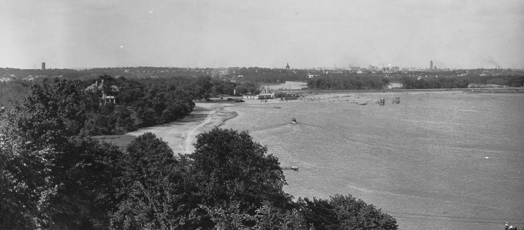
Lake Calhoun’s northwest shore and Bath House in late 1910s. Photo taken from Minikahda Club. Click to enlarge. (Minneapolis Park and Recreation Board)
Note how far into the lake the diving platforms were built.
One of things I like from this photo is a sense of the connection between Lake of the Isles and Lake Calhoun. There is some open land between them. This was taken a few years before construction began on the Calhoun Beach Club across Lake Street from the bath house.
Another remarkable feature of this photo is the prominence of the Basilica on the skyline west of downtown. The Basilica was dedicated in 1914.
This is the view that Theodore Wirth hoped could one day be incorporated into the park system if the Minikahda Club ever relocated. Wirth wrote in the 1906 Annual Report of the Board of Park Commissioners, his first, that this view was of “such scenic beauty that it is almost a crime to pass it unnoticed.”
David C. Smith
© David C. Smith
Glenwood Spring: A Premier Park — and Water Supply?
Filed under: Minneapolis Parks: General | Tags: Bassett's Creek, Bassett's Creek Valley Park, H.W.S. Cleveland, Horace Cleveland
Comments (1) H.W.S. Cleveland, the landscape architect who created the blueprint for Minneapolis’s park system in 1883, made his first visit to Glenwood Spring near Bassett’s Creek in north Minneapolis in the spring of 1888. In a letter to the Minneapolis Tribune, published April 22, 1888. Cleveland described that visit.
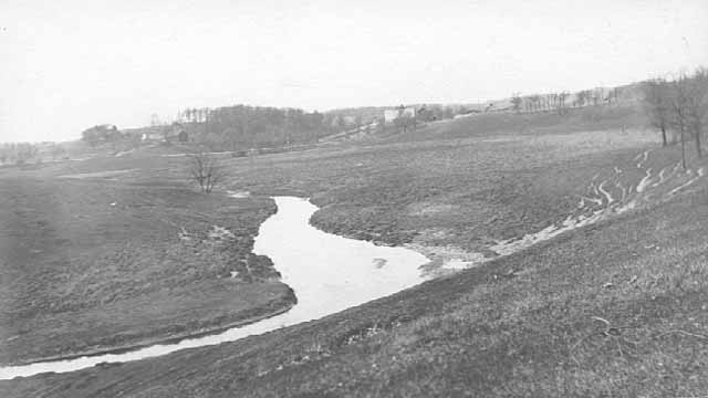
Bassett’s Creek in the vicinity of Glenwood Spring, about 1910 according to the Minnesota Historical Society. I’m not familiar enough with the lay of the land in the area to guess the exact location of this scene, but I was struck by how open the landscape was, especially given Horace Cleveland’s description of “large bodies of very fine native trees” in the vicinity of the spring. Perhaps those groves were behind the photographer. (Minnesota Historical Society)
Cleveland’s letter addressed the subject of the city’s water supply, noting that when he and his family moved to Minneapolis from Chicago in 1886 they experienced deleterious health effects — “winter cholera,” as he put it — that they thought might be associated with Minneapolis tap water. He reported that after they began using Glenwood spring water his family had no further health issues and they also found the spring water more “palatable” than the city water, which was taken from the Mississippi. Cleveland wrote that he had used the spring water for more than a year before he visited the neighborhood of the springs. When he finally did visit,
“I was not alone surprised and delighted by the beauty of the springs themselves, and their topographical surroundings, but amazed and grieved that my attention had not been called to the locality when I first came by invitation of the park commissioners, five years previous, to study the possibilities of park improvements.”
Cleveland claimed that because he was put in charge of an engineer, Frank Nutter, who, he was told, was familiar with all the sites desirable for park purposes, he didn’t feel it necessary to look at areas he was not shown. Cleveland didn’t believe he was deceived or misled, but…
“An hour’s inspection of the area in the neighborhood of these springs satisfied me that no place in the neighborhood of the city, except the vicinity of Minnehaha falls, was so well adapted by nature for the construction of a park, comprising rarely attractive topographical features — while the distance from the center of business was less than half that to Minnehaha, and the apparently unlimited capacity of the springs, which gushed from the hillsides at various points over a widely extended area, seemed to offer every possible opportunity for the ornamental use of water.”
The prospect of bubbling springs of clear water and “hills and valleys of graceful form” that wouldn’t have needed “heavy expense in grading” to be transformed into parkland appealed to Cleveland’s aesthetic sense. He also asked “whether it is worth our while to ascertain the character and capacity of the springs” to supply the entire city with water. Cleveland suggested that if the springs were capable of meeting the city’s water needs, “the city should secure them, and enough land around them to preserve them from contamination, and then enclose the area as an ornamental reservoir as had been done in Philadelphia, New York and Boston.

This photo of the ice house at Inglewood spring was taken in the mid-1890s. (Minnesota Historical Society)
What Cleveland didn’t know at the time was that the Glenwood and Inglewood springs may not have been well-known in 1883, when Nutter hosted Cleveland’s park exploration visit. Most accounts I can find of Glenwood Spring’s history claim it was discovered by William Fruen in 1884, a year after Cleveland wrote his “Suggestions for a System of Parks for the City of Minneapolis.” One account suggests Fruen found the springs in 1882. Some accounts have him discovering Glenwood Spring when building a mill on Bassett’s Creek, others when he was digging a fish pond. The latter tale, probably a tall one, was disseminated on the cached web site of the Glenwood Inglewood Water Company.
Fruen’s history with the spring includes filing the first vending machine patent in U. S. history. He invented a coin-operated machine in 1884 to dispense his spring water by the glass. Fruen also attempted to distribute his water by pipeline as Cleveland thought might be desirable. John West, owner of the posh West Hotel in Minneapolis, Thomas Lowry and Fruen wanted to build a two-mile pipeline from the spring to the West Hotel, and also sought permission to pipe the water into homes and restaurants along the way. That plan was vetoed in 1885 by Mayor George Pillsbury.

The Glenwood-Inglewood Company, 1910. The Glenwood and Inglewood springs were on adjacent property and run as separate water companies until about 1896. Until then, they were competitors. See below. (Minnesota Historical Society)
In the spring of 1885, Fruen published ads in the Tribune touting the purity of water from Glenwood Spring. He published a chemical analysis of the water conducted by Professor James Dodge of the University of Minnesota, who attested, “This water is extremely pure, being almost entirely free from organic matter.”
The ad invited readers to, “Drive out and see as fine a spring as you ever looked upon.” Another admonition in the copy is particularly interesting given the long association in later years of the Glenwood and Inglewood springs:
“Do not confound this spring with the Inglewood. Ours is the Glenwood.”
William Fruen’s son, Arthur, donated 13 acres of land along Bassett’s Creek to the park board in 1930, which was the beginning of Bassett’s Creek Valley Park. Arthur Fruen was a city council member at the time and an ex-officio member of the park board. I don’t know if that 13 acres included the site of the original spring—in other words, if Cleveland’s vision of a park that included the spring was partially realized nearly 50 years after he first saw it.
David C. Smith
© David C. Smith
An Early 8-hour Day?
Filed under: Minneapolis Parks: General, Victory Memorial Drive | Tags: Victory Memorial Drive
Comments (2) Teamsters who worked for the Minneapolis Park Board began working 8-hour days in 1913. With only a quick look into the history of the eight-hour workday, that strikes me as a fairly early concession by the park board. Many industries still worked longer days. The park board Proceedings for 1913 reported that park commissioners adopted this proposal on May 6, 1913.
To the Honorable Board of Park Commissioners:
Your Standing Committee on Employment, to whom was referred the communication of the International Brotherhood of Team Owners asking that eight hours constitute a day’s work for teams employed by the Board, respectfully reports that the matter has been given careful consideration and your committee now recommends that all teams and men now employed by the Board working nine hours per day be placed upon a basis of an eight-hour day at the same wage per day now being paid.
Respectfully submitted,
J. W. Allan, W. F. Decker, P. D. Boutell, P. C. Deming
Nothing in park board proceedings indicates why employees were given what amounted to a 12.5% raise that year. Pay rates published in the February 18 proceedings list teamster pay at $2.50 per day and pay for teams at $5.00 per day. In other words, a driver was worth the same as a horse.
You have to keep in mind that a teamster in those days was usually someone who drove a “team” of horses—thus “teamster”—not a truck, in case you’ve ever wondered.
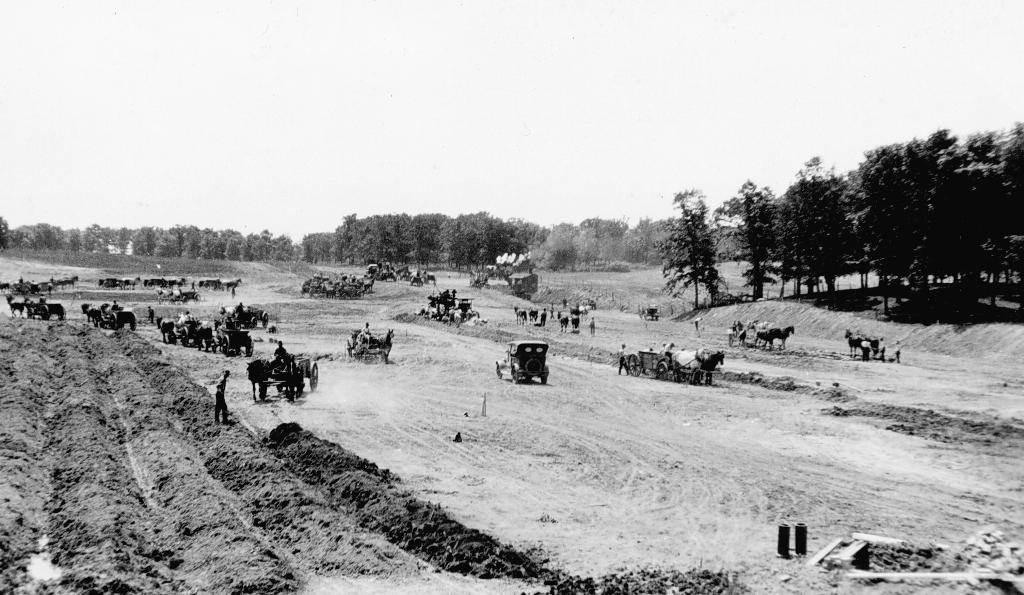
Work crews building what became Victory Memorial Drive in north Minneapolis in about 1920. (Minneapolis Park and Recreation Board)
The photo above, taken a few years after the reduction in work day was approved, shows that horses and automotive vehicles worked side-by-side on road construction.
Theodore Wirth wrote in 1911 that some projects had been delayed in Minneapolis parks because there were no teams to be hired. Perhaps the shorter workday was necessary to compete for teams in 1913.
I know that a widespread 40-hour work week didn’t come for many years in some places and some industries. Perhaps someone with a better knowledge of labor history than I can provide some context for the decision of the park board to reduce the work day from 9 to 8 hours, but maintain the same pay. Also is there any significance in the request for shorter work day coming from the brotherhood of “Team Owners,” which I gather was not the same as the International Brotherhood of Teamsters. Any thoughts?
David C. Smith
© David C. Smith
The Beginnings of a Garden
Filed under: Minneapolis parks | Tags: Armory Garden, Kenwood Garden, Louis Boeglin, Minneapolis Sculpture Garden, The Parade, Theodore Wirth
Comments (1) One hundred years ago next week, Theodore Wirth made a request of the Minneapolis park board that made possible one of Minneapolis’s most cherry-ished landmarks—and parks. The park superintendent who was known for his passion for gardens—and also for hiring a talented full-time park florist, Louis Boeglin—asked the park board to approve preparing a square of ground next to the Minnesota National Guard Armory for a garden. At least for a summer.
The Society of American Florists and Ornamental Horticulturists (SAFOH) were holding their national convention at the Armory in August 1913. The Armory had been built in 1906 between Kenwood Parkway and Vineland Place adjacent to a park known as The Parade. To the east of the Armory, bordering on Lyndale Avenue, was an empty plot of ground that Thomas Lowry had donated to the park board in 1906. It was that square that Wirth asked for. The park board approved Wirth’s request the day he made it — March 4, 1913 — for the “free use” of the space by SAFOH for “an extensive display of outdoor plants consisting of the best adapted hardy and tender plants that can be used for the decoration of public and private grounds and of plant novelties that are not yet known to many florists.”

The green space to the right of the Armory was the site of the SAFOH Garden. Lyndale Avenue is at right. Kenwood Parkway, which no longer goes through, is at top. Thomas Lowry’s residence is where the Walker Art Center is now. (Atlas of Minneapolis 1914, reflections.mndigital.org)
To prepare for this test garden, the board authorized Wirth to provide the property with “the necessary dressing of good loam,” which the board would pay for from funds allocated for The Parade.
As recently as 1911 Wirth had proposed to use the space for tennis courts, in keeping with the active recreation focus of the park, but those courts were not built. (See plan in 1911 Annual Report.)
The Minneapolis Tribune enthused that the garden would be one of the “most beautiful and extraordinary displays that the city has ever enjoyed.” The Tribune estimated (April 20) that some bulbs to be planted, which began arriving from florists around the country in April, were valued at up to $100 each and, therefore, a guard would be posted at the garden site.
As the dates of the convention approached much was written in local newspapers about the floral display that would inform and entertain 1,500 guests from around the country who would make Minneapolis the “floral capital of the country” for a week (Tribune, August 10, 1913). Private railroad cars were to bring florists from the major eastern cities and so many florists were coming from, or through, Chicago that both the Milwaukee Road and Great Northern had dedicated trains from there solely for convention goers. 
The Tribune observed that membership in the Society was “coveted” because there was an “exchange of courtesies” among members, such as the “invaluable service” of a “telegraph order system between cities.” Many of us have used the FTD—originally Florists’ Telegraph Delivery—system, which was created in 1910, only a few years before the Minneapolis convention. The image of Mercury, at left, was first used in 1914.
The garden was such a huge hit—with florists and Minneapolis citizens—that one park commissioner recommended keeping the garden and naming it the Wirth Botanical Garden. Wirth, who was vice president of the national society before the convention, was unanimously elected president of the national organization while it was in session in Minneapolis.

The 1913 garden adjacent to the Armory, looking southwest from the intersection of Lyndale Avenue, coming in from left, and Kenwood Parkway, at right. The photo was taken from the Plaza Hotel between The Parade and Loring Park. The garden is now part of the Minneapolis Sculpture Garden. (MPRB)
The park board did support the continuation of the garden the following year and it became a popular attraction for decades, in part because of the labels that identified the plants. But the garden was never named for Wirth. It was referred to as the “Armory Garden” until the Armory was demolished in 1934. At that time the land where the Armory stood was donated to the park board. After that the garden became known as “Kenwood Garden.” Those floral gardens, introduced as a concept 100 years ago next week, unquestionably facilitated the current use of the grounds as quite a different type of garden.
For the rest of the garden’s story, look for a documentary being produced by tpt and the Walker Art Center this spring in celebration of the 25th birthday of the Minneapolis Sculpture Garden. It is scheduled to premier in late May.
David C. Smith
NOTE May 30,2013: The tpt documentary can now be viewed here.
© David C. Smith 2013
H.W.S. Cleveland and Lake Harriet
Filed under: Lake Harriet, Landscape Architects, Minneapolis parks | Tags: H.W.S. Cleveland, Horace Cleveland, Lake Harriet
Leave a Comment While looking for other things I keep encountering bits of information that deepen my understanding of and appreciation for Horace W. S. Cleveland’s profound contribution to Minneapolis parks.
More than a year before the creation of the Minneapolis park board and Cleveland’s “Suggestions for a System of Parks for the City of Minneapolis” a Minneapolis Tribune editorial, published January 22, 1882, announced “A Prospective Park.” The editorial noted that Philo Remington and Col. Innes, who ran the Minneapolis Lyndale Motor Line, were planning to lay out a park on the shores of Lake Harriet and “may eventually” donate it to the city. The newspaper had high praise for the property.
“It is a natural forest, with hill and dale, and comprises without exception one of the most beautiful bits of woodland scenery that can be found anywhere.”
But it was the following sentence that caught my attention and provided more insight into Cleveland’s influence in the city before the park board.
“Col. Innes has made arrangements with Mr. Cleveland, the celebrated landscape gardener, who laid out Union Park, Chicago, whereby that gentleman will take immediate charge of the work of superintending the laying out of a park that will not only be a credit to the city but an inestimable benefit to our citizens.”
I have found no evidence in Cleveland’s correspondence that he was actually hired for any work at Lake Harriet; he never mentions it. And who knows, Remington and Innes may have been blowing smoke. They had other grand plans that didn’t materialize. But whether they were serious or not about a park at Lake Harriet, the editorial indicates the high regard in which Cleveland was held in the city and the likelihood that, at the very least, he was already being consulted on park matters, especially around the lakes, before the park board existed.
A bit prematurely the Tribune enthused, “Minneapolitans may now congratulate themselves on the fact that a public park, the need of which has so long been felt, will soon be completed for their pleasure and benefit.”
Only a year later, at the next session of the legislature, a bill was passed that created the Minneapolis Board of Park Commissioners. Although Cleveland was never credited with designing any of the parks at Lake Harriet, he likely had considerable influence on how the lake shore was perceived and, later, developed.
Just another small piece of evidence of Cleveland’s immense influence on the Minneapolis park system. And yet his name does not appear on a Minneapolis park property.
David C. Smith
For more on Col. Innes’s plans for Lake Calhoun and Lake Harriet see this entry.
For more on why Cleveland’s name should be connected to the vast park that is the Mississippi River Gorge see this entry and this one, too.
For more on Cleveland in general, search above for his name or click on his name in the tag cloud at right. I’ve written quite a bit about him. Take a closer look at the map from his “Suggestions…” at right, too.
Minnehaha Falls Photos
Filed under: Minneapolis parks, Minnehaha Falls | Tags: Minnehaha Falls, Minnehaha Park
Comments (2) Karen Cooper tells me she has photos of more 19th- and early 20th-Century bridges over Minnehaha Creek at Minnehaha Falls than the ones I’ve already posted. You can see those photos and more next Sunday, Feb. 10, at 2 pm at Hennepin History Museum. (Get more info here.)
I’m told that Karen has the most amazing Minnehaha Falls collection. I’m looking forward to seeing part of it myself for the first time. Hope to see you there.

The 1910 stone arch bridge was actually made of reinforced concrete and given a facade of boulders found in the vicinity. (Minnesota Historical Society)
David C. Smith
Fear in the Hearts of Children: More from the Autobiography of Francis A. Gross
Filed under: Minneapolis parks, Mississippi River | Tags: 1862 US-Dakota War, Francis A. Gross, North Minneapolis
Leave a Comment Last weekend I read Mni Sota Makoce: The Land of the Dakota and Our Way or the Highway: Inside the Minnehaha Free State. That followed a recent rereading of Folwell’s History of Minnesota, Volume I, and I also had read Spirit Car recently. They were part of my continuing research into the history of Minnehaha Falls. (More on that project soon.)
With the sad story of the disintegration of relations long ago between American Indians and whites fresh in mind, I recalled a passage in the unpublished autobiography of former park commissioner Francis Gross. (Background on Gross and his autobiography.) Gross was born in Minnesota in 1870 and lived near the intersection of Plymouth (13th) Avenue and Washington Avenue North in north Minneapolis from 1875 into his teen years. Among his memories of childhood on the north side was this:
“Until shortly after 1880, the shore lands of the Mississippi river were grandly beautiful. Other than a small sawmill at the bridge on Plymouth Avenue, there stood virgin timber of many varieties. For a few years after our coming to the northside, each spring many Indians, their squaws and papooses, would travel from the north on the river in canoes and locate their camp at about 14th Avenue North on the river flat there. The many Indians, young and old, their tepees, boiling pots, the furs and beaded leather goods and trinkets they had brought to trade or sell was an interesting sight. Each evening they would entertain their white visitors with war dances. Made their drums taut by the heat of the campfire, painted their faces in most hideous designs and wore their best and most beautifully patterned and beaded dress. As this time was not long after the most serious of the wars with Indians in this territory, fear of the Indian was in the heart of every child. It can therefore be easily guessed that the sight of these hideously painted, tomahawk-swinging savages, performing at night in the sinister-appearing light given by a few torches, was a scene as exciting as any small boy could wish for.” (Emphasis added.)
I wonder if that fear may have been heightened for Gross as a child because he grew up in a community of predominantly German immigrants. In another section of his hand-written autobiography he recalled:
“On the north side until after 1885, it was common to hear German spoken whenever people congregated. The early settlers of the north side were mostly of German birth…When German immigrants came to Minneapolis, very few spoke English, hence it was necessary that they were met on their arrival by an American. Often, my father would meet those immigrant German families with his grocery delivery wagon.”
The connection between the fear and the immigrants is that many of the settlers in the Minnesota River Valley—the violent epicenter of the 1862 U.S.-Dakota War—were also German immigrants. I suspect the violence of that war was painfully felt by many in the German community in Minneapolis, too. While that war was 13 years in the past by the time Gross’s family moved to north Minneapolis, local newspapers carried many stories in the later 1870s of continuing battles between American Indians and U.S. forces not far to the west, including lurid accounts of battles featuring such famous names as Custer, Sheridan, Sitting Bull and Crazy Horse.
I hadn’t planned to write here about this passage in Gross’s autobiography when I first read it, because it did not relate to parks or early land use in Minneapolis, nor do I believe it reflects on Gross whom I have always admired as a fair, just, and humane man. But I was drawn back to it in the convergence of my research. Gross’s description had power and it had nothing to do with some anachronistic terms. Rather, the power comes from the poignant phrase: “fear of the Indian was in the heart of every child.”
It is not the object of the fear that impressed me—I can imagine as well fear of the White Man in the hearts of Indian children—but the sad realization that fear in the hearts of children can take lifetimes to conquer.
The greatest injustices, the greatest atrocities grow from fear of some monolithic, broadly-defined “Other” instilled young—a conviction reinforced last night as my daughter described watching the film Hotel Rwanda in her geography class.
The dangers of implanting fear in the hearts of children are as great today as ever. Let’s keep that seed from being planted and nourished in our children’s hearts.
David C. Smith
If you know of accounts or pictures of American Indian encampments along the Mississippi River in North Minneapolis in the 1870s-1880s, such as Gross described, I’d like to learn more.
© David C. Smith
Park Progress: 100 Years of Engines, Wheels, Automobiles and Metropolitan Parks
Filed under: Grand Rounds, Minneapolis parks | Tags: bicycle paths, Edmund J. Phelps, Grand Rounds, Minneapolis parkways
Comments (1) Writing one hundred years ago this week, then Minneapolis park board president Edmund Phelps, made several observations in the park board’s annual report for 1912 that attracted my attention.
“I notice in the Board’s report, especially between 1894 and 1900, frequent references to our bicycle paths and the very general use of the bicycle itself. It will be remembered that at one time there was great agitation for fine bicycle paths upon all main thoroughfares. During the last few years there has been nothing said in the reports and there has been no attention paid to keeping up bicycle paths for the reason that the use of the wheel, unfortunately, was very largely diminished.”

This is one of my favorite park photos. It first appeared in the Minneapolis park board’s 1896 annual report. It shows bicycle paths around Lake Harriet created that year. The layout of walking path, bicycle path and carriage way, there were no cars yet, is almost identical to today. (Minneapolis Park and Recreation Board)
The “wheel,” as Phelps called the bicycle, has made quite a comeback. Bicycle riders were generally called “wheel men” then although as this picture demonstrates riding bicycles was not strictly a male pursuit. Perhaps most remarkable however, despite the fact that today you could spend more on a bicycle than the park board paid for Lake Calhoun, the basic concept of the bicycle has not changed at all: two wheels on a connecting frame, pedals, seat, handlebars—and a dog out for exercise.
Another thematically related passage from Phelps’s 1912 report is worth noting.
“We ought not to mow forty acres of lawn at Lake of the Isles by handpower, but the best power lawn mowers, such as are used by parks and country clubs, should be provided, as they facilitate the work and reduce greatly the expense per acre.”
I have no idea if Phelps was a stockholder in The Toro Company.
Greater Grand Rounds
Finally, Phelps recommended an idea that was not new, but was placed in an automotive context I haven’t seen before. Writing thirty years after the creation of the park board, Phelps looked thirty years into the future and foresaw,
“Two or three trunk lines of excellent highway will connect the eastern and western extremities of our great country. Good roads of high class construction will prevail throughout every state of the Union. While these state roads should and will radiate from the large cities of the commonwealths, yet all will connect in a nearly direct line with the nearest transcontinental highway.”
Combining the development of good roads for automobiles with his prediction that there would be more than a million people in the Twin Cities in thirty years (1943), Phelps wrote,
“Long before that time the boulevard system of the two cities should be extended so as to make one ‘Greater Grand Rounds’ of one hundred miles or more.”
Phelps then described a parkway system that followed Minnehaha Creek to Lake Minnetonka, around that lake, then south from Excelsior to Shakopee, down the Minnesota River valley and its “enchanting scenery” to Fort Snelling, through St. Paul to and around White Bear Lake, then to Anoka and the Mississippi River, passing many beautiful lakes on the way,” then back to Minneapolis along the river. Phelps concluded,
“I am sure that a boulevard similar to the one suggested eventually will be built. An enabling act should be prepared and presented to the Legislature at the present session, and passed, so that the work may be prosecuted later.”
The parkway Phelps recommended was never authorized or built, but parks have been acquired along much of the route he suggested.
The First Automobile Ordinance
Phelps vision of automobiles, transcontinental highways and “Greater Grand Rounds” is not surprising given his early adoption of the automobile himself.
Phelps first appearance before the park board, more than a year before he was elected to be a park commissioner, was on behalf of the Automobile Club of Minneapolis. On May 7, 1903 Phelps requested permission for the club to have an automobile hill-climbing contest on the steep hill on Kenwood Parkway near Spring Lake. Hill-climbing contests were an early form of car racing, seeing whose car could climb a steep hill in the shortest time. As an inducement for approval of the club’s request perhaps, Phelps invited park commissioners and friends to attend the contest and afterwards be given a ride by automobile around the parkways.

1903 Model A Ford. It also came in a two-seat version. It was manufactured only in red. It had a top speed of 28 mph. (americanfords.com)
Phelps’s request for use of the parkway was approved, but he may have gotten more than he bargained for. Immediately following approval of his request, the board directed the Privileges and Entertainments Committee to meet with the City Council Committee on Ordinances to develop an ordinance governing the use of automobiles in parks.
The park board subsequently passed an automobile ordinance on June 20, 1903. The ordinance restricted automobile speeds to 15 miles per hour, required that each car powered by gasoline have a muffler, that each car have a bell or horn, and a have at least one lighted lamp if operated after dark. In addition,
“Every person operating an automobile shall stop upon request or signal from any person in charge of a horse or horses, and shall also stop whenever a horse or horses show signs of fright at the automobile.”
Anyone convicted of violating the ordinance was subject to a fine of $2-$100 and, if in default of payment of a fine, imprisonment in the City Work House for a period of up to 90 days.
To give you some idea of how new cars were at the time, the Ford Motor Company was incorporated only four days before the park board’s automobile ordinance was passed in June 1903 and Ford’s first three Model A’s were manufactured the next month. The success of those vehicles is still evident in Minneapolis where we refer to the Ford Dam and Ford Bridge, named for their proximity to and relationship with the Ford assembly plant in St Paul. The construction of the Ford Bridge made Minnehaha Park easily accessible to St. Paulites.
David C. Smith
© David C. Smith
Cleveland’s Van Cleve: A Playground or a Pond
Filed under: Landscape Architects, Minneapolis parks | Tags: H.W.S. Cleveland, Horace Cleveland, Jackson Square, Theodore Wirth, Van Cleve Park
Comments (6) A tantalizing paragraph.
“Professor Cleveland submitted a plan of the improvement of the 2nd Ward Park, whereupon Commissioner Folwell moved that that part of the park designated as a play ground be changed to a pond and that so changed the plan be approved.”
“2nd Ward Park” was later named Van Cleve Park. It was the first park in southeast Minneapolis, not far from the University of Minnesota. I find it odd that the park board would create a pond in a city full of lakes, streams and rivers, but more significant, and unexpected, is what the pond replaced in the plan. A playground. Huh! Horace William Shaler Cleveland, often referred to in Minneapolis by the honorific “Professor,” never seemed a playground sort of guy.
The paragraph appeared in the proceedings of the Minneapolis Board of Park Commissioners from its meeting of May 19, 1890. That date is important because at that time few playgrounds existed. Anywhere.
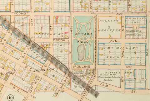
Before Van Cleve Park was named, it was referred to as 2nd Ward Park as seen here in the 1892 Plat Book for Minneapolis. The man-made pond took the place of what would have been the first “playground” in a Minneapolis park. (C.M. Foote & Co., John R. Borchert Map Library, University of Minnesota)
Unfortunately Cleveland’s drawings for Van Cleve Park didn’t survive. Six of his other park designs—large-scale drawings—are owned by Hennepin History Museum, but the Van Cleve plan is not among them. Neither was it ever published in an annual report, as several other of his plans were. No documents explaining Cleveland’s intent with his plan have been found either, so we really don’t know what type of playground he imagined for the center of the new park. We can only guess.
The Infancy of Playgrounds
The idea of public space devoted to play was still quite new at the time—to Cleveland and to everyone else. In his most famous book, Landscape Architecture as Applied to the Wants of the West, published in 1873, Cleveland mentioned “play ground” only as something that might be desired in the back yard of a home. In his famous 1883 blueprint for Minneapolis’s park system, Suggestions for a System of Parks and Parkways for the City of Minneapolis, he doesn’t mention play or playgrounds at all. Even in the notes that accompanied his first six individual park designs in Minneapolis (unpublished) in 1883 and 1885, he never mentioned play spaces. Yet, in 1890, when he was 76 years old, Cleveland proposed to put a playground in a new park.
The idea was just being explored elsewhere then. In 1886 Boston had placed sand piles for kids play in some parks. The next year San Francisco created a formal children’s play area in Golden Gate Park. In New York, reform mayor Abram Hewitt supported a movement in 1887 to create small, city-sponsored combination parks and playgrounds, but that effort bore little fruit until a decade later. In 1889, Boston created a playstead at Franklin Park and an outdoor gymnasium on the bank of the Charles River, a collaboration of a Harvard professor and Cleveland’s friend Frederick Law Olmsted. Historian Steven A. Riess calls it the “first American effort to provide active play space for slum residents.” (See Riess’s City Games for a fascinating account of the growth of sports in American cities.)
The social reform movement, which later helped create playgrounds in many cities, was gaining steam with the publication in 1890 of Jacob Riis’s, How the Other Half Lives, a glimpse of grinding poverty in the slums of New York. That movement would have an enormous impact on cities in the early 1900s, especially Chicago, which became the playground capital of the United States, led in part by Jane Addams of Hull House settlement fame.
Even though Cleveland addressed many of his efforts in civic improvement to providing fresh air, green spaces and access to nature’s beauty for the urban poor, especially children, he seems an unlikely proponent of playgrounds in parks. Based on the bitter complaint in a letter to William Folwell, July 29, 1884, I had taken Cleveland to be opposed to any manufactured entertainments at the cost of natural beauty. He wrote from Chicago,
“There’s no controlling the objects of men’s worship or the means by which they attain them. A beautiful oak grove was sacrificed just before I left Minneapolis to make room for a baseball club.” (Folwell Papers, Minnesota Historical Society)
Yet, we have proof that Cleveland had a much more positive view of play areas for children in parks than he had of ball fields. A playground at Van Cleve Park, would have been a first in Minneapolis parks.
The Pond Instead
With the revised plan of the park approved, construction of the pond began immediately in the summer of 1890. A pond of 1.5 acres was created in the southern half of the park. The earth removed to create the pond was used to grade the rest of the park. That winter the park board had the pond cleared of snow so it could serve as a skating rink, too.

The artificial pond at Van Cleve was a popular skating rink. (Minneapolis Park and Recreation Board)
There must have been problems keeping water in the pond, because the next summer it was drained and the pond basin was lined with puddled clay. An artist’s rendering of the park in the 1891 annual report shows a fountain spraying a geyser of water in the middle of the pond. I’ve never seen a photo of such a fountain at Van Cleve, or read an account of it, but a similar fountain was built into the pond at Elliot Park, the only other pond created in a Minneapolis park, so it is possible a fountain existed. The park board erected a temporary warming house and toilet rooms for skaters on the pond beginning in the winter of 1905.
When Theodore Wirth arrived in Minneapolis as park superintendent in 1906, he placed a priority on improving Van Cleve Park as “half playground, half show park.” He recommended creating a sand bottom for the pond so it could be used as a wading pool and building a small shelter beside it that could double as a warming house for skaters.
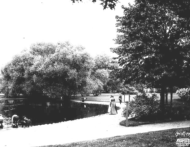
Van Cleve pond, 1905. (Sweet, Minnesota Historical Society)
The first playground equipment was installed in Van Cleve Park in 1907, following the huge popularity of the first playground equipment installed at Riverside and Logan parks in 1906.
The shelter was finally built in 1910, along with shelters at North Commons and Jackson Square. The Van Cleve shelter was designed by Minneapolis architect Cecil Bayless Chapman and was built at a total cost of just over $6,000. It included a boiler room, toilets and a large central room. The Van Cleve shelter was considerably more modest than the shelters at Jackson Square and North Commons, which cost approximately $12,000 and $16,000 respectively. On the other hand, neither of those parks had a pond. (Jackson Square actually had been a pond at one time, however, called Long John Pond. The cost of the Jackson Square shelter rose due to the need to drive pilings down 26 feet to get through the peat on which the park was built.)

The original recreation shelter at Van Cleve Park was built in 1910 facing the man-made pond. (Minneapolis Park and Recreation Board)
Wirth published a new plan for Van Cleve Park in the 1911 annual report. Although he claimed that Van Cleve demonstrated that a playground and show park could exist without “interfering” with each other, the playground occupied only a narrow strip of land between the pond and 14th Ave. SE. There were still no playing fields of any kind in the park then.
In 1917, Wirth recommended pouring a concrete bottom for the pond, really converting it into a shallow pool. Two years later the park board did pave the pond basin, but with tar macadam.

The Van Cleve shelter well after 1940 renovations, date unknown. (Minneapolis Park and Recreation Board)
Very few improvements were made at Van Cleve, or any other park in the city, for many years from the late-1920s to the late- 1940s. In 1935, in his last year as park superintendent, Wirth recommended that a swimming pool be built at Van Cleve in place of the pond, but the park board didn’t have the money for such a project during the Great Depression.
The park did get its share of WPA attention in 1940 when the federal work relief agency completed several renovations on the Van Cleve shelter to improve its capacity to host indoor recreation activities. Also included in those repairs were such basics as a concrete floor in the shelter’s boiler room. Comparing the two photos above, it’s obvious that the veranda was enclosed and the ground around the shelter was paved as well.
The man-made pond was finally filled in 1948. A modern, much smaller concrete wading pool was built to replace it the next year. The little rec shelter stood until a new community center was built at Van Cleve in 1970. By then Van Cleve, like most other neighborhood parks in the city, had been given over almost completely to active playgrounds and athletic fields.
Despite Cleveland’s aborted provision for a playground of some kind in his plan for Van Cleve Park in 1890, I imagine him astonished and a bit saddened to see neighborhood parks change so completely from the pastoral reserves and quiet gardens he had once preserved or coaxed from the urban landscapes of his time.
David C. Smith
© David C. Smith
 Minneapolis Park History