Approaching Lake Calhoun
Filed under: Minneapolis Parks: General | Tags: Dean Parkway, Lake Calhoun, William Berry Parkway
 Comments (7)
 Two photos from the 1950s, and two that are much older, show how people got to Lake Calhoun once upon a time. Both photos are from the Minnesota Historical Society’s online collection. I haven’t written about that collection in some time, but I continue to use it extensively for research on Minneapolis parks and other historical subjects. You should take a look if you haven’t before. It’s a treasure.
The first photo shows the intersection of Lake Street, Dean Parkway and West Calhoun Parkway, looking west.
Many Minneapolis parkways were once called “boulevards”, but that changed in 1968 when the Minneapolis park board renamed nearly all of them “parkways.” The park board wanted to create uniformity in treatment, but also believed that by calling them parkways, people would better understand that they were owned by the park board and were part of the park system. I still refer to them as boulevards at times, out of habit, as do many others. Curiously, Google maps hedges, labelling the road around the west side of Lake Calhoun “W Calhoun Pkwy” and “Calhoun Blvd”.
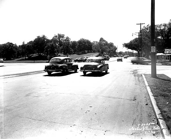
Travelling west on Lake St. at Dean Parkway. West Calhoun parkway begins at far left. (Norton and Peel, Minnesota Historical Society)
Note that the lot on the southwest corner of the intersection (upper left) is still undeveloped in 1953.
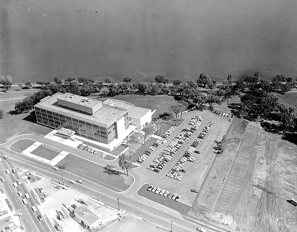
Aerial view, 1956. Excelsior Blvd. is in the foreground. Minnesota Historical Society)
The earliest photos I’ve found of the American Hardware Mutual Insurance Company building on the site are dated 1956, such as this aerial photo from the Minneapolis Star Journal Tribune.
The park board never owned that piece of land, although it would have been a good addition to the lake park. The park board reported in 1916 that the purchase of 93 acres on that corner was pending, but the deal never was completed. The land behind the building to the southwest was once a small bay of the lake, which the park board filled with material dredged from the lake bottom.
Perhaps it’s simply an issue of the resolution of this photo, but I don’t see traffic lights even though it appears that east- and west-bound traffic is stopped. The lights must have been installed about this time, because the city engineer had developed an initial plan for lights at this increasingly busy intersection in 1951.
The photo below was taken at the opposite, or southeastern, corner of Lake Calhoun at about the same time.

36th Street approaching the southeastern corner of Lake Calhoun, 1955. Lakewood Cemetery is on the left. (Norton and Peel, Minnesota Historical Society)
The photo is notable especially because the foundation of the street railway bridge over 36th Street still stands. This was the location of the rails that went to Lake Harriet and beyond to Excelsior and Lake Minnetonka. Of course, there were no traffic lights at the intersection of 36th and East Calhoun Parkway either.

East Calhoun Parkway in about 1890. Looking north from Lakewood Cemetery.(Minnesota Historical Society)
The trestle had been there since before the park board built the parkway. (See more on the Lyndale Railway Company at Lake Calhoun and Lake Harriet.) In the photo at right you can see the bridge foundation (far right), in front of the carriage turning east onto 36th Street. The fountain in the boulevard for watering horses was an interesting touch. So was the scalloped hedge between the parkway and the lake. Does anyone know when the street railway bridge supports were torn down?
Most of the earliest parkways around lakes ran right along the water’s edge. That feature of early parkways is more prominent in the photo below of the end of Calhoun Parkway in about 1905. At that time the parkway ended where it turned south to connect to Lake Harriet. The land behind the photographer in this photo was private land all the way around the west shore of the lake back to Lake Street and the top photo.

The end of Calhoun Parkway at the south end of Lake Calhoun in 1905. The road turned to the right, the future William Berry Parkway, connecting to Lake Harriet. (Minnesota Historical Society)
The photo below shows the approach to the north end of Lake Calhoun from about the same time period as the photo above.

The north shore of Lake Calhoun from Lake Street, facing west in about 1902. (Minnesota Historical Society)
This photo shows Lake Street facing west at the northeast corner of Lake Calhoun. This was before the park board acquired the north shore of the lake. The only park land around the lake at this time was Calhoun Parkway beginning at the left of this photo and continuing to the previous photo.
David C. Smith
A Missed Opportunity: The Witch’s Hat Is Closed for Another Year!
Filed under: Minneapolis Parks: General, Tower Hill Park | Tags: Frederick W. Cappelen, Tower Hill Park, Witch's Hat
Comments (6) 
The view from Tower Hill — at the base of the Witch’s Hat. Imagine the view from the observation deck above. (Talia Smith)
For years my “To Do in Minneapolis” list has included a climb that I have never made. And it’s not something I can do just any old day. We get one evening a year and that’s it. And once again I missed my chance. I wasn’t paying close enough attention that the Prospect Park/Pratt School Ice Cream Social was May 31. The night of that neighborhood party is the one time a year that the Witch’s Hat Tower on Tower Hill Park is open for climbing.
The climb would have been especially gratifying this year because it was the tower’s 100th birthday. The City of Minneapolis built the water tower on the hill, with the park board’s permission, in 1913. As explained before, the park was already named Tower Hill, at the request of neighborhood residents, when the Witch’s Hat water tower was built.
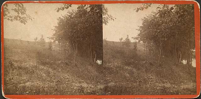
Since my earlier post on the Witch’s Hat, I found this stereopticon image of “Cheever’s Tower” dated 1858. (Minnesota Historical Society)
The Witch’s Hat tower was designed by Frederick Cappelen, as noted on a plaque that was put on the tower in 1999. I have a complaint about that plaque.
Cappelen is described on the plaque only as a “Norwegian architect.” Concise, but really misleading. Yes, he was Norwegian by birth, but he had immigrated to the United States at the age of 23 in 1880. He went to work for the City of Minneapolis in 1886 as a bridge engineer and in 1893 was elected Minneapolis’s City Engineer. He left that office in 1899, but was elected City Engineer again in 1913 and held that title until he died of complications from appendicitis in 1921. So, although Norway-born, he lived nearly his entire adult life in Minneapolis and during much of that time was a city employee.
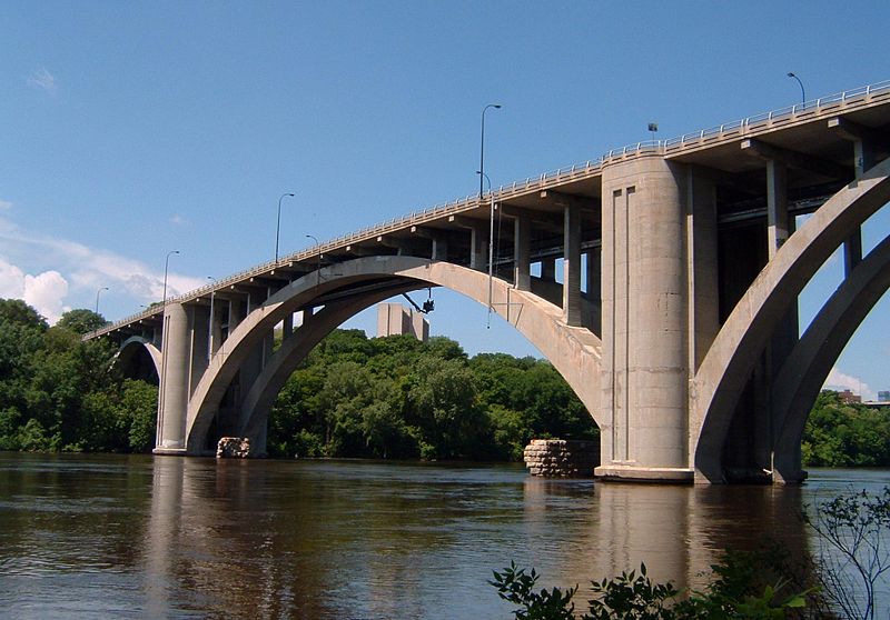
The graceful arch of the bridge was the world’s longest concrete span at the time it was completed in 1923. (Mulad)
Cappelen’s greatest achievements in Minneapolis had nothing to do with the Witch’s Hat. He was the designer of the Franklin Avenue Bridge over the Mississippi, which was completed after his death. At that time, the bridge was the longest concrete-span bridge in the world, with a central span of 400 feet. The bridge’s official name is F. W. Cappelen Memorial Bridge.
Cappelen was also a key figure in designing the city’s water distribution system from the 1890s into the 1900s. He was so well-known as a bridge designer and a water works designer that his obituary was included in both the Proceedings of the Society of American Civil Engineers and the Journal of the American Water Works Association.
Cappelen was a Public Servant
Here’s my complaint about the plaque. I have no problem with identifying him as a “Norwegian architect” despite the fact that he was as American as everyone else in the city. My problem is with not identifying him as a public employee, as the City Engineer, a description that has far more to do with our memory of him than that he was Norwegian by birth.
The omission of his status as a public employee is part of my larger complaint that too many people praise everything in the private sector and disparage everything and everyone in the public sector. Too many people have such blind reverence for business methods and profit motives that they cannot distinguish between public and private good and the sometimes vastly different challenges involved in each. Some public problems cannot be solved by methods designed to maximize private profits.
I have also witnessed first-hand brilliance, stupidity and sloth in both government and corporate worlds. I have known very successful business people whom I would not trust to walk my dog around the block for fear that they’d screw it up somehow — or sell my dog before they made it back. I have known public employees with whom I would trust my life.
I have no tolerance for people who assume that someone who gets his or her paycheck from a government entity is incompetent and that everyone who works for a profit-making enterprise is more industrious and resourceful.
I have as much tolerance — none — for those who assume the only reason we have parks at all was a conspiracy of capitalists to enrich themselves. This myopic view, in my recent experience, seems particularly prevalent among people writing doctoral dissertations and some of those advising them.
To emerge from our present political quagmire, we have to be better than those extremes.
If there is a valuable lesson in Minneapolis park history it is that a great variety of people, with disparate philosophies and political views, have worked together on issues of the common good and achieved marvelous results. They included “capitalists” who looked beyond self-interest and profit, and they certainly included talented and dedicated public servants — like Frederick William Cappelen, City Engineer.
I’m sorry I missed again a chance to climb the tower he imagined 100 years ago. I’ll have to settle for a walk over his bridge.
David C. Smith
NOTE (6/6/2013): abockheim raises an excellent point in a comment on the post I linked to above about the identity of the tower that led to the naming of Tower Hill. Can anyone shed light?

An illustration of the view from Cheever’s Tower in 1857 by Edwin Whitefield. The lithographer was W. Endicott & Co. (Digital gallery of the New York Public Library.)
Here’s the link to the above illustration. I can’t picture this view from the campus or Tower Hill.
© David C. Smith 2013
Minneapolis Sculpture Garden is 25
Filed under: Minneapolis Parks: General | Tags: Armory Garden, Minneapolis Sculpture Garden, The Parade
Leave a Comment Happy 25th Birthday Minneapolis Sculpture Garden!
Sorry, I forgot to inform you of the original air date of tpt’s history of the Minneapolis Sculpture Garden. It premiered last Sunday evening on tpt/MN. The half-hour documentary was made to celebrate the 25th birthday of an extraordinary public space.
The program will air again at various times throughout the summer. Check tpt schedules or watch it here.
Producer Mark Fischer and executive producer Tom Trow did an excellent job telling the story; they even let me be in it!
The Sculpture Garden was a collaboration between the Minneapolis Park and Recreation Board, which owns and maintains the land, and the Walker Art Center, which designed the garden and selected the sculptures. It’s a Minnesota treasure.
The following photos show the transformation of part of the Sculpture Garden when the Armory Garden was created in 1913.

The southern half of the Sculpture Garden site before it was designated to become a garden in 1913, looking southwest, Armory in background, Walker Art Center site at left, Lyndale Avenue in lower left, Kenwood Parkway, now closed at right. (Minneapolis Park and Recreation Board)

The same site as above ready for planting for the 1913 convention of the Society of American Florists and Ornamental Horticulturists. (Minneapolis Collection, Hennepin Country Library)

The 1913 Armory Garden. The photo was taken from the Palace Hotel between The Parade and Loring Park. (Minneapolis Park and Recreation Board)
Whether you love the Sculpture Garden, or don’t really care, it is a remarkable use of parkland — one of many examples in the Minneapolis park system. As I said in the video, I think the transformation of one corner of a recreation park into an art park is a remarkable example of how the use of public land can — and should — change over time. It’s another tribute to the wisdom of those who envisioned the park system and the need to set aside land for public enjoyment. Because we own the land, we can adapt its use to meet our needs, however they may be defined and redefined. Brilliant!
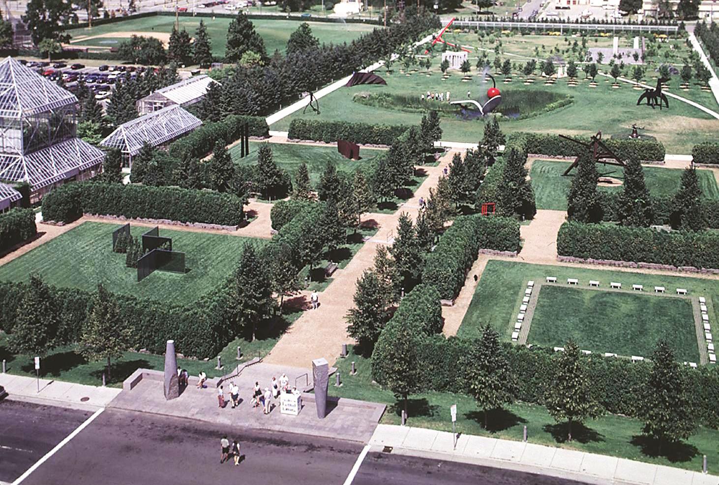
The same land in the photos above, but seen from the south. (Minneapolis Park and Recreation Board)
When’s the last time you visited the Sculpture Garden? Maybe it’s time to take another look.
David C. Smith
© 2013 David C. Smith
The Stadium the Pillsburys Built: Northrop Field at the U of M Where Ticket Scalping Became Illegal
Filed under: Minneapolis parks | Tags: Alfred F. Pillsbury, Golden Gophers, John S. Pillsbury, Northrop Field, University of MInnesota football
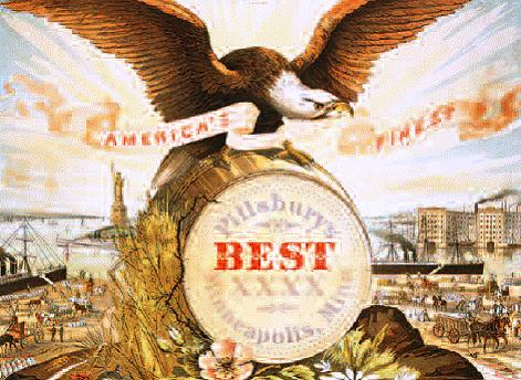
Leave a Comment Alfred Fisk Pillsbury is probably best known for three things in Minnesota other than his “Best XXXX” flour-making name.
 One, he was a major contributor to the Minneapolis Institute of Art. The renown of MIA’s Chinese collection is due in large part to Pillsbury bequeathing his personal collection of bronzes and jades to the museum. He had a good eye in addition to deep pockets.
Two, he played for eight University of Minnesota Gophers football teams 1886-1893. That’s right, eight! As long as a student was working toward a degree in those days, he was eligible to compete on a university’s athletic teams. Earned your degree? No problem! Pursue another, stay eligible. So young Pillsbury—”Pilly” to fans and sportswriters—twice captain of the team and, literally, the owner of the team’s only football his freshman year, went from undergraduate courses to law school. Eight years, six as the team’s QB!
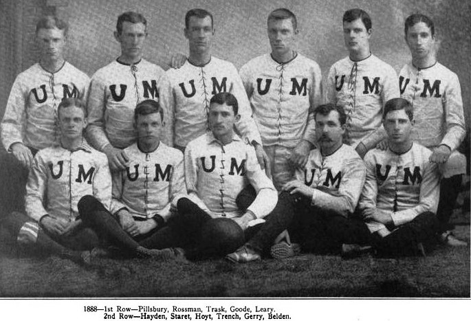
Alfred F. Pillsbury (first row, far left) with the 1888 Gophers. This was the third year of his eight year career at the University of Minnesota. He was captain of the 1887 and 1889 teams. He began his playing days in 1886 as a lineman, but at only 142 pounds he was soon shifted to quarterback. He was not as small as it would seem by today’s standards; players who weighed 200 pounds were considered gigantic then. Don’t you love those lace-up shirts? They were made of canvas to provide some protection and elusiveness. It was hard to get hold of the snug-fitting canvas.
His eighth year on the team is a bit mysterious. Most sources, including the History of Minnesota Football, published in 1928 by the General Alumni Association of the University of Minnesota, claim Pilly’s football playing days ended in 1892. John Hayden writes in a chapter titled “The Early Days”: “For long and creditable performance no one has surpassed Alf. Pillsbury. He played good football on the first team, in 1886, and on successive teams until 1892, when he completed his law course.”
But it seems as if Pilly had one game left in him. The Minneapolis Tribune’s account of the Gophers’ 40-0 thrashing of the Wisconsin Badgers—the biggest game of the year—on November 11, 1893 describes several Pillsbury plays as a halfback that day. He scored two touchdowns. A drawing that illustrates the story shows “Pilly” carrying the ball. It was apparently his only appearance during the 1893 season. Though he wasn’t on the team’s roster for the year, he does appear in the 1893 team photo (too grainy to reproduce here). He was still in law school—he didn’t actually graduate until 1894—so perhaps the team felt they needed their former star to defeat the highly regarded team from Madison and complete a second consecutive undefeated season.

The Marx Brothers in Horsefeathers (mobypicture.com)
The Badgers’ star halfback that day, Lyman, had faced the Gophers before as a student at Grinnell College in Iowa. He reportedly vowed he would stay in college until he beat Minnesota—which evokes images of Professor Wagstaff, Pinky and Baravelli in “Horsefeathers” a few decades later.
The Wisconsin game in 1893 was not the last time Pillsbury took the field in a Minnesota football game. He twice played against the Gophers—and lost—in 1895 representing the Minnesota Boat Club and the Ex-Collegiates.
Perhaps the greatest tribute to Pilly as a player was offered by the famous University of Chicago coach Amos Alonzo Stagg. Writing in the University of Minnesota Alumni Weekly football special in 1914, Stagg recalled the first contact he ever had with a Minnesota team when he refereed a Gophers game in 1891. Pillsbury was one of four players he remembered from that game more than 20 years earlier, noting that Pilly was a “stalwart” at his position and “made a great reputation.”

The 1889 Gophers were a more relaxed outfit. Pillsbury, the captain, is front center.
Digression: Golden Gophers. When did the University of Minnesota officially add “Golden” to Gophers? How silly. “Back when I was a kid they were just Gophers and that was plenty good for us.” (Spits tobacco, misses spittoon.) Golden? That’s trying way too hard. “Gopher” too wimpy for you? Well, “Golden” makes it seem like we’re begging for a wedgie. Every time a national sports announcer says “Golden Gophers”, I can hear the eye-roll. There was a time when the “Gophers” were winners. Since the “Golden” was added? Losers. Posers. Hosers. It’s a curse. In the name of Jerry Kill and Richard Pitino, drop the Golden! Especially since the teams have gone to an ugly yellow—Grotesqueyellow Gophers!—instead of gold for a uniform color anyway. If “Buckeye”—the least fearsome nickname/mascot ever— doesn’t need enhancement, why should “Gopher”? Ohio St. still does okay.
Alfred Pillsbury’s third most visible personal accomplishment was serving as a Minneapolis park commissioner for 19 years between 1925 and 1946. He was president of the board for three years in the 1930s. My favorite quote from the annual reports that Pillsbury wrote was from the park board’s report for 1933.
While pleading the case for greater spending on park recreation programs, even in the depth of the Depression, Pillsbury wrote that providing recreation was, “just as vital as any function of government, not excluding that of the apprehension and conviction of criminals and the education of our youth.” I doubt that anyone has ever put the case more strongly for the value of recreation in our society.
That’s how the world seems to remember Alf, as Lori Sturdevant calls him in her family biography, The Pillsburys of Minnesota. But in these days of stadium subsidies and related land development d-d-d-deals—Gestribheit!—it is worth noting something else Pilly/Alf did.
The Stadium that Outlawed Ticket Scalping
Alfred Pillsbury is credited with playing a pivotal role in creating a new stadium for the Gopher football teams. Until 1896 — Pilly’s entire playing career — the Gophers usually played football on the baseball field behind the West Hotel in downtown Minneapolis. The biggest drawback was that the baseball field wasn’t quite long enough for a regulation football field, which lead Northwestern University to protest their loss on the shortened field in 1892. In 1896 the team moved to a new field, a sandy burr patch next to the Armory on the University campus. For three years spectators were accommodated by chairs placed around the field. In 1899, the athletic department borrowed $1,500 from the Board of Regents to construct a 3,000-seat grandstand. A board fence around the field was built by students, although the student newspaper reported with shock that some students climbed over the fence to attend games. The new field was named after University President Cyrus Northrop.

Alfred F. Pillsbury (Minneapolis Park and Recreation Board)
Northrop Field, however, was never considered adequate. Dissatisfaction with the field led to a discussion in 1900 between the Dean at the time, Fred Jones, and former Minnesota Governor, President of the Board of Regents, and Pilly’s dad, John S. Pillsbury. The elder Pillsbury had also been one of the original twelve commissioners when the Minneapolis Board of Park Commissioners was created in 1883. John and Alfred Pillsbury were the first father-son duo to achieve park commissionerhood. The most recent was Leonard and Scott Neiman. The Neiman family could add a generation this year, given the candidacy of Scott Neiman’s son, Josh, for the park commissioner seat from the same southwest Minneapolis district that elected his father and grandfather.
Subsequent to his chat with Fred Jones, John Pillsbury privately purchased six lots adjacent to the Armory football field and convinced the city to vacate Arlington and Union Streets through the campus at that point. His intention apparently was to give the lots he had purchased to the university to expand the football stadium, but this plans were not completed before he died in 1901. His son and heir, Pilly, completed the plan, however, deeding the land to the University. The University then augmented the gift with the purchase of additional land and paid for the construction of a new grandstand that would seat 10,000 and provide standing room for nearly 10,000 more spectators. Pilly then stepped up again with the money to construct a brick wall around the entire athletic complex, which also included a running track and a baseball field.
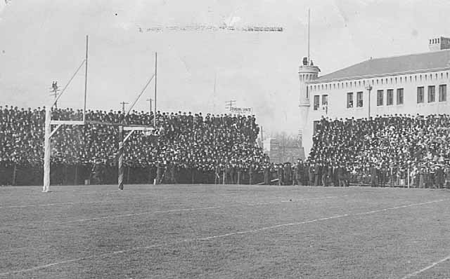
The west end zone and standing room sections of Greater Northrop Field with the a portion of the Armory at right. My favorite part of the photo is the fans on the pole outside the stadium. Alfred Pillsbury’s brick wall wasn’t going to keep them from watching the game. (Minnesota Historical Society)
The new stadium, Greater Northrop Field, which opened in 1903, was considered exceptional for its time, but pressure for a bigger and better stadium would grow in only a decade.
Coaches Never Change. After praising the Gophers’ stadium as one of the “very best football playing fields in the country” a coach expounded, “Fine as this is, however, it does not meet the present football requirements of the University…Michigan, Northwestern, Wisconsin, Chicago, and Illinois have all far outstripped Minnesota in extent of grounds and equipment. A new field with concrete stands and ample acreage is a not unreasonable hope for the near future. Commodious, clean dressing quarters, baths and locker rooms in place of the present inadequate cramped, dirty, unsanitary, and unhygienic quarters should accompany the new field. While bearing but indirectly on football and yet affecting all athletic enterprises at the University, it might be well to mention that Minnesota has one of the poorest college gymnasiums in the country, in no wise in keeping with its needs or its athletic accomplishments.”
— U of M football coach Dr. Henry L. Williams writing in the Alumni Weekly, November 9, 1914. Norwood Teague could use that speech today with minor revisions.
The demand for tickets to see the Gophers play in those days is demonstrated by a law passed by the Minnesota Legislature in 1913, Chapter 521 of the General Laws of Minnesota.
“Be it enacted by the Legislature of the State of Minnesota:
Section 1. Prohibiting theater ticket scalping.–No person, firm, or corporation shall sell or offer or expose for sale any ticket of admission to any theater, opera, concert, athletic contest, or other public entertainment at a greater price than the same are being sold or offered for sale by the management of the same.”
Although the law is couched in general entertainment terms, the Minneapolis Tribune reported April 27, 1913 that the bill was passed expressly to prohibit the scalping of Gopher football tickets, which had been prevalent when the Wisconsin Badgers came to Northrop Field to play the Gophers the previous November. At that time — the Tribune headline was “Football Fever Grips City” — tickets that normally cost $1.50 were selling for as much as $10, putting them out of reach of most fans. (The first Minnesota legislation I can find that applies to excess charges on tickets of any kind is a 1893 law that prevented ticket brokers from raising prices for steamship and railroad tickets.)
The new law got its first great test when Coach Stagg’s University of Chicago eleven came to Minneapolis for a mid-November game in 1913. The 10,000 seats in the grandstand sold out the same morning tickets went on sale even though a limit of six tickets per person was implemented to curtail the anticipated aftermarket in tickets despite the new law. While the penalty for scalping tickets was a $10-$100 fine or 10-90 days in the county jail, the University also imposed punishment for students who sold their student tickets, which cost $5 for the season. The penalty was harsh: expulsion from school. Minneapolis police assigned three plain clothes detectives to patrol “hotel lobbies, cigar stores and saloons” to catch anyone trying to sell tickets over face value. (It wasn’t until 1949 that the legislature expanded the law to prohibit selling tickets below face value, too.)
The big game, played on a field that had been protected from frost all week by a covering of 18 tons of hay, lived up to advance billing resulting in a dramatic 13-7 win by Chicago. Despite the home team’s loss, the Tribune reported an “orgy of celebration” after the game that had never been equalled in Minneapolis history. The paper credited the Chicago win to Coach Stagg’s “shifty plays.” Chicago went on to beat Wisconsin the next week — the entire Wisconsin team was rumored to be at the Minnesota game scouting the Chicago squad — and won the Big Nine conference championship. It was the Big Nine, instead of the Big Ten, at the time because Michigan had temporarily withdrawn from the conference. Chicago was a member then, not replaced by Michigan State until 1949 after Chicago dropped out of major college athletics. What became of all that hay remains a mystery.
At conference meetings the week after the 1913 season ended, faculty representatives of Big Nine schools agreed to try out using numbers on players uniforms the next year. They also appointed Chicago’s coach, Amos Alonzo Stagg, to lead an effort to “devise a signal code by which officials in football games can inform announcers of the causes of penalties”.(Minneapolis Tribune November 29, 1913)
Digression: Squirrels, ferrets and flats. Lest you think that the 1913 legislature was being frivolous in passing laws against ticket scalping, it also passed laws against killing any kind of squirrel in public parks and repealed the law that had made it illegal to use ferrets to hunt rabbits in Hennepin, Ramsey and St. Louis counties. Apparently after passage of the law banning ferrets, the rabbit population had exploded and was destroying fruit trees in those counties. I don’t know if or when either law was ever amended or repealed. So if you plan to use your ferret to hunt rabbits in Minneapolis this summer, you might want to check first. The legislature also granted city councils the authority to determine where flat or apartment buildings could or could not be built, one of the first steps toward zoning restrictions and modern city planning.
After several years of intense public pressure, Northrop Field was replaced after only 21 years by Memorial Stadium, which opened in 1924. Alfred Pillsbury was reported to have donated $50,000 toward the construction of that stadium.
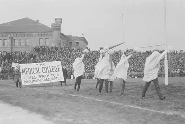
Medical school students demonstrating support for a new stadium about 1920. (Minnesota Historical Society)
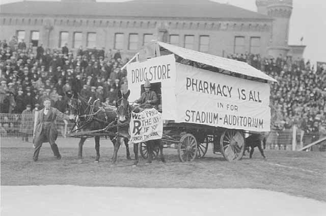
Pharmacy students demonstrating for a new stadium around 1920. (Minnesota Historical Society)
The reference to the “auditorium” in the photo above was to what became “Northrop Auditorium.” The fundraising campaign for Memorial Stadium also included raising money to build Northrop Auditorium.
Although I don’t know if you can still use ferrets to hunt rabbits in Minneapolis, the laws prohibiting selling tickets to sporting events and other entertainment for more or less than face value was repealed in 2007.
While no evidence remains of the Pillsbury family’s contributions to athletic facilities at the University of Minnesota long ago—I don’t know if Pillsbury descendants contributed toward construction of The Bank or other newer facilities at the U—a statue of John S. Pillsbury remains prominent on campus for his role in creating the entire University. History also remembers both John and Alfred, father and son, for their contributions to Minneapolis through the park board; in that sense our city parks are also part of their legacy. And you can still go to the Minneapolis Institute of Art and find items donated from the collection of Alfred F. Pillsbury. I think I can write with confidence that he is the premier art collector in history who also played on his college football team for eight years.
David C. Smith
© 2013 David C. Smith
Friday Photo: Forgotten Field on Nicollet Island
Filed under: Minneapolis parks, Mississippi River | Tags: DeLaSalle High School, Nicollet Island
Comments (2) Funny that in all the debate a few years ago about the football “stadium” for DeLaSalle High School on Nicollet Island, I don’t recall seeing the photo below of the island in 1947. I discovered this photo in Borchert Library’s Minnesota Historical Aerial Photos Online that I wrote about last week.
Nicollet Island clearly had a baseball field adjacent to the high school long before the park board acquired much of the island.

Detail of Nicollet Island, 1947, with a baseball field in the middle. For the full image go here, then click on the green push-pin north of Nicollet Island. (John R. Borchert Map Library, University of Minnesota)
I do recall great distress caused by the possibility of closing “historic” Grove Street across the center of the island in order to install the football field. But no one mentioned then that the eastern half of Grove Street that was to be closed had been historically (among other things) the left field fence of a baseball field. I had no idea. The things you learn from photos.
The photo demonstrates that some claims from both sides of the football field argument were wrong. Those who opposed the field in part for fear of losing a historic street were more than 60 years late to that argument. On the other hand, those who claimed that DeLaSalle, in its 100-year history, had never had a home athletic field were wrong, too. Maybe they didn’t have a football field to call home, although it looks as though one might have been squeezed in there in the ’40s, but they obviously did have a home baseball field at one time.
For the earliest plans for a park on Nicollet Island see previous posts on Horace Bushnell, the first person to suggest it, and the first ideas for parks upriver from St. Anthony Falls.
I don’t know who actually owned or maintained the field in the 1940s. Something to investigate. Some old “D” yearbooks must have more photos.
David C. Smith
© 2013 David C. Smith
Friday Photos: Thousands of Historical Aerial Views
Filed under: Minneapolis Park History Resources | Tags: Borchert Map Library, Minnehaha Auto Tourist Camp, Minnehaha Falls, Minnesota Historical Aerial Photos Online, University of Minnesota Digital Content Library
Comments (8) The closest thing to time travel. That’s what today’s photo recommendation gives you through more than 100,000 photos that allow you to track the growth of Minneapolis — and the rest of the state — from the sky.
I’m not aware of any larger local source of aerial photography than Minnesota Historical Aerial Photos Online (MHAPO). The collection is part of the John Borchert Map Library at the University of Minnesota. It was created by Joseph Koeller in consultation with the Borchert Library staff.
I’ve written before of the Borchert Map Library because I use their maps often, especially their plat maps of Minneapolis from 1892 and 1903, which I have on my “favorites” bar on my computer.
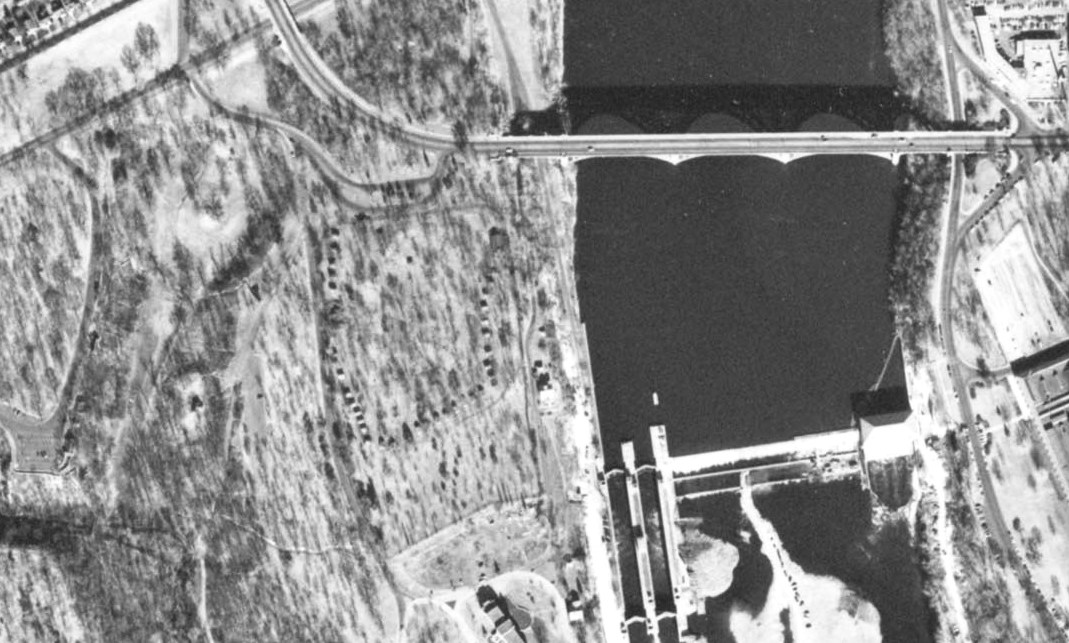
While researching the history of the auto tourist camp, which the park board operated at Minnehaha Falls from 1920s into the mid-1950s, I wanted to get some sense of the layout of the 35 cabins that were offered for rent on a nightly basis. I had never found any depiction of the layout of the camp until I found this photo from October 1953 at the MHAPO site. See the U-shape of dark dots on the bluff to the left of the Ford Dam? Gotta be those cabins. It’s the Wabun picnic area now. I’ll be writing more about the tourist camp soon.
For more recent aerial photos of many parts of Minneapolis and the metropolitan area, I go to the University of Minnesota’s Digital Content Library. Below are two photos from that collection using the search term “Minnehaha Park.” They provide a marvelous way to track changes in the landscape. The only shortcoming of this superb collection of images is that they are not dated.

Long ago you could drive up to the edge of Minnehaha Falls. You could watch the falls from your car. A park drive passed between the falls and the pavilion with the red roof.
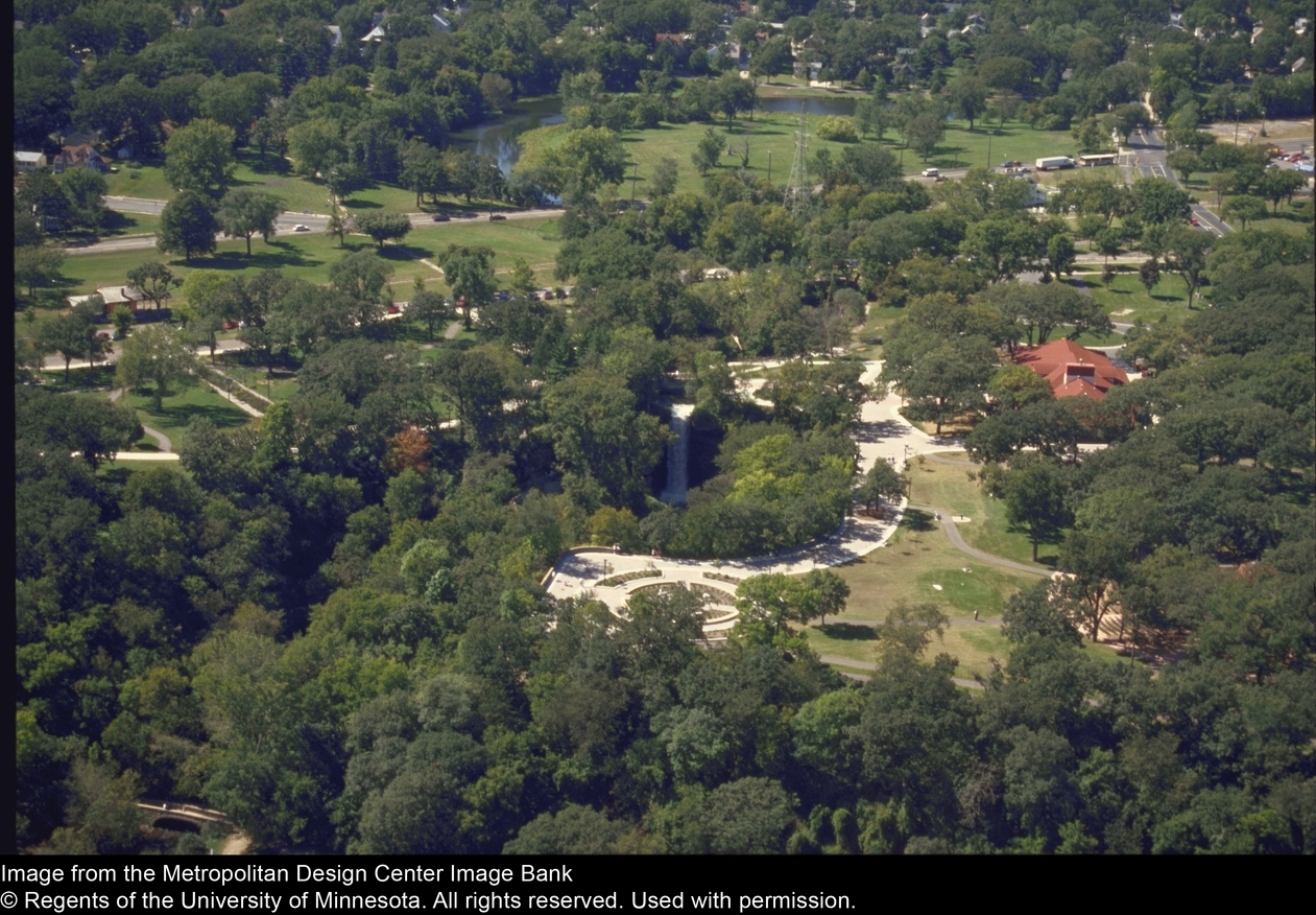
After the 1992 renovation of the park, the parking lot was moved away from Minnehaha Falls and cars could no longer drive right to the edge of the gorge. The former parking lot was replaced by the garden in this picture, which features some verses from Henry Wadsworth Longfellow’s “Song of Hiawatha”, to which the Falls owed its world-wide renown.
Note that both photos were taken before Hiawatha Avenue was expanded and put under a land bridge at Minnehaha Parkway (upper right corner of the photos) in the 1990s. Had the Minnesota highway department had its way, the horizontal stretch of green near the top of the picture would have become an elevated freeway in the 1960s. The Minneapolis park board went all the way to the U. S. Supreme Court in a successful effort to block that freeway. That is an important story of true park heroes, such as Robert Ruhe, Walter Carpenter, Ed Gearty and others, which I hope to tell in greater detail soon.
Some of the photos and maps in the Digital Content Library collection require login to see more than a thumbnail, but many permit viewing in greater detail by the general public.
It’s worth noting that both the Borchert and Digital Content Library collections are the product of our state university—a demonstration that all of us can benefit from the presence of a major university in our community. Our taxes at work! Yeah, I complain about taxes too, but things like parks and libraries and universities and historical societies contribute enormously to the richness of our lives. My life anyway. Nearly all the resources I draw on to produce these articles are public resources. They are available to all without charge. They are an important part of our heritage—and, I hope, our legacy.
David C. Smith
© David C. Smith 2013
Lofty Words, Lofty Ground: Portius C. Deming
Filed under: Minneapolis Park Hero, Minneapolis parks | Tags: Deming Heights, Deming Lake, Itasca State Park, Mary Gibbs, Portius C. Deming, St.Anthony Parkway
Comments (1) One of the lesser-known park heroes in Minneapolis history left us with inspiring advice —for both citizens and park commissioners. His most memorable words come from his writing in park board annual reports when he was the president of the Minneapolis Board of Park Commissioners 1915-1917. His most enduring actions to create parks and preserve nature’s beauty, however, had nothing to do with Minneapolis. We would honor his service to the state and city if we maintained more thoughtfully the park named for him.
Julius Caesar enriched the common people of Rome by bequeathing to them all his parks and gardens. The people of Minneapolis do not need await the death of an Emperor to enjoy such treasures. They possess them in their own rights. Every man or woman that walks beneath the refreshing shade, or treads the green grass of our parks, or rides upon their sparkling waters, or listens to strains of enchanting music in an environment of nature’s beauty — every boy and girl that gains health of body and mind within our playgrounds — every one of these can proudly say, “These parks are mine; I am joint owner of all these splendors.”
— Portius C. Deming, President, Minneapolis Board of Park Commissioners, 1915 Annual Report
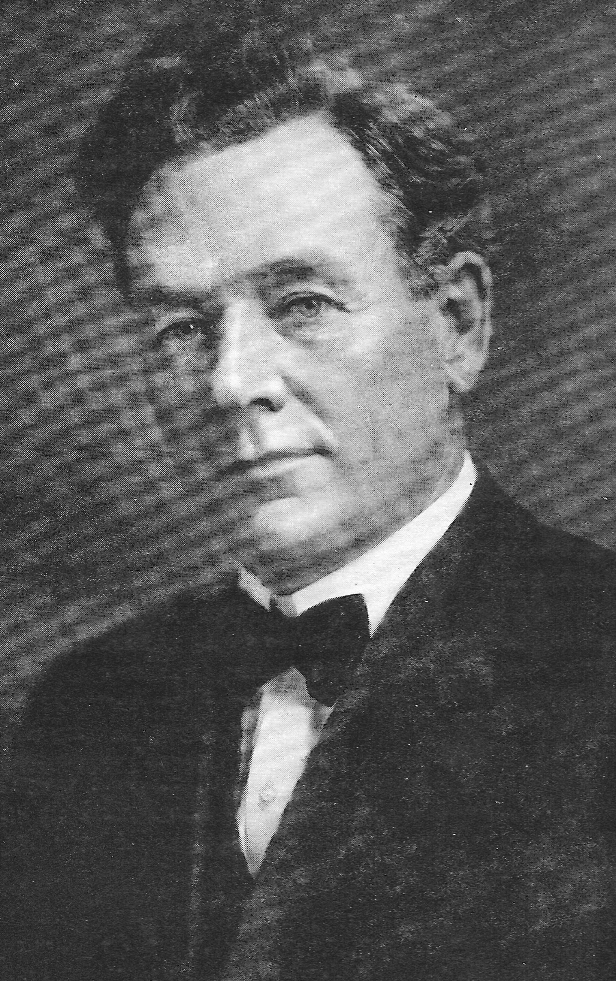
Portius C. Deming, 1916. Lofty hair, too. (MPRB)
Portius C. Deming was a realtor and insurance agent — the two professions went hand-in-hand in the years Minneapolis grew the fastest in the late 1800s. Deming lived on the corner of 23rd Ave. NE and Central Avenue and had his office a block away on the other side of the street. He was one of the men who helped put together the proposal for the park board to acquire what became Columbia Park in northeast Minneapolis in 1892. He was 38 at the time.
The creation of a large park, which included part of Sandy Lake, was certainly in Deming’s long-term business interest, although he was not a large landowner in the vicinity of the park and residential development had not reached within several blocks of the new park at the time. Most of the land near the park had not yet been platted into residential lots — and the Shoreham railroad yard was already quite extensive to the south of the new park. While sprawling railroad yards have never been converted into attractive scenery, the yard did provide the jobs that would support the construction of new houses, new businesses, and a flourishing community north of what was commonly called “New Boston” in northeast Minneapolis.
Still, as a business leader and realtor, Deming certainly would have appreciated the benefit to the city of a large park beside the only significant body of water in that part of the city. And William Folwell had argued convincingly for such a park only a year earlier when he applied the term “Grand Rounds” to the linked system of parks he supported.
Deming was elected to the park board in the fall of 1894 after he won the Republican Party nomination for the seat over the incumbent president of the park board, J. A. Ridgway. Ridgway would later become the secretary to the Board, a full-time position, a job he held for more than 20 years. (Deming’s wife was the niece of Adin Austin, one of the original 12 park commissioners when the Minneapolis park board was created in 1883.) Deming did not complete his six-year term as park commissioner, because he was elected to the Minnesota House of Representatives in November 1898. He had to relinquish his park board position when he took his seat in the House in January 1899.
It took very little time for Deming to make an impact in the House and leave a profound mark on the state.
Deming Lake
Driving north on Highway 71 about twenty miles beyond Park Rapids, you reach the southern entrance to Itasca State Park. You’ve already passed so many lakes since Park Rapids—Fishhook, Portage, Little Mantrap, Eagle, Island—not to mention “Christmas World”, and you are so eager to get to Lake Itasca and the slippery stones that create a path across the lake’s outlet stream, the modest beginning of the Mighty Mississippi, that you probably don’t notice the third lake on your left after you enter the park: Josephine, Arco, Deming. Yep, Deming as in Portius C. The lake once named “Danger”, was renamed to honor the legislator from Minneapolis who adroitly managed the passage of a law in 1899 that appropriated the first money for the state to buy private land within the 35 square miles that had been designated Itasca State Park in 1891.
The legislatures of Minnesota and the United States had already contributed the land they owned within the park boundary, and the railroads cut generous deals to convey their lands to the park, but about 8,000 acres still remained in private hands in a patchwork within the park boundaries, including several tracts bordering Lake Itasca itself. Deming and others believed that the additional land had to be acquired by the state before it was clear-cut of its majestic white pines. A “Stumpage State Park” had little appeal, particularly as a setting for the source of the continent’s mightiest river.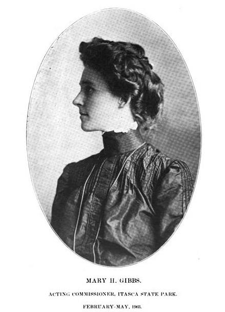
The “Deming Law”, which appropriated $20,000 for land purchases, didn’t end battles between park proponents and the lumber companies over rights to cut pine, create lumber roads across public park land, and dam Lake Itasca to float the lumber down the Mississippi River to Minneapolis saw mills. But it did establish a precedent and legal justification for action.
One of the great stories in Minnesota park history is how Mary Gibbs, in 1903, confronted the lumbermen and opened the dam they had built on the Mississippi River that was flooding the shores of Lake Itasca. Gibbs was the acting commissioner of Itasca State Park at age 24 after the previous commissioner, her father, died. She was quickly stopped from upholding state law by a local judge and promptly replaced by Governor Van Sant with someone more malleable to lumbering interests. Still, the young woman who had the integrity and courage to take on powerful interests is an inspiration. The visitors center in the park at the headwaters of the Mississippi is named for her.

Lake Itasca as log reservoir, 1903. (Illustrated History of Itasca State Park)
Despite the efforts of Deming, Gibbs and others like them, lumber companies opposed preservation efforts in the park effectively for many years. But Deming and Gibbs made a critical contribution to protecting natural resources, a forward-thinking effort that continues to provide benefits today.
For the in-depth story of efforts to protect the park, and Deming’s role, read the Illustrated History of Itasca State park by Jacob V. Brower here. Note whose picture is on the cover of this edition of the Collections of the Minnesota Historical Society. You can’t mistake the high hair of Portius C. Deming. That book is also the source of his signature.
From Park to Parole
Deming’s influence as a legislator was also significant as an advocate for the University of Minnesota, but the other piece of legislation with which his name is linked is the bill passed in 1901 providing for the possibility of parole for convicts with life sentences. The “Deming Bill” is also referred to as the “Youngers’ Bill”, because its practical effect was to provide for the parole of two infamous residents of Stillwater Prison who had been model prisoners for 25 years: Cole and Jim Younger.
The Younger brothers had been captured after the notorious robbery of the Northfield Bank by the James-Younger Gang in 1876. Cole and Jim Younger entered a plea of “guilty” in 1876 to the bank robbery and murder of a bank clerk to avoid the death penalty. If they had pleaded “not guilty” and been convicted, they could have been executed — and I don’t believe anyone, including them, ever claimed they hadn’t committed the robbery, although accounts of the robbery suggest they did not shoot the clerk. Another brother, Bob, also plead guilty to the charges, but died in Stillwater prison of tuberculosis in 1889. Following the passage of Deming’s Parole Bill, written solely for humanitarian purposes, the Youngers were paroled. (The only other prisoner who met the strict conditions of the bill was an old man who refused parole because he had been in prison so long he no longer knew anyone outside of prison and had no means to support himself. Prison was his home.) Jim Younger committed suicide a year after his release. Cole Younger returned to his Missouri home and lived until 1916.
The results of a quick search revealed only one other especially interesting piece of legislation sponsored by Deming. In 1903, he sought a legislative appropriation of $5,000 for victims of a famine in Sweden, Norway and Finland — an unusual venture into international relations. The bill did not pass.

As president of the park board, Deming presided over the dedication of The Gateway in 1915. He also commanded the podium at the dedication of two other memorials that year, one to Thomas Lowry at Virginia Triangle; the other to Gunnar Wennerburg at Minnehaha Park. (MPRB)
President of the Park Board
After three sessions in the legislature, Deming stepped away from politics for a few years until he was tapped by the Minneapolis park board in November 1909 to complete the unexpired term of park commissioner Milton Nelson, who had resigned. The other candidate nominated to fill Nelson’s post was a young banker from north Minneapolis, Francis A. Gross. While Deming prevailed in that selection process, Gross was elected by park commissioners to fill another unexpired term a few months later in May 1910. With a few interruptions, Gross served on the park board into the 1940s.
Following the expiration of the partial term that he was selected to fill, Deming stood for popular election for another term and during that term was elected President of the park board by his fellow commissioners for 1915 and 1916.
Deming’s focus as a park commissioner is not associated with any particular park developments, although the decade of his second stint on the board was an extremely productive time in Minneapolis park history: the lakes were linked with canals, land for the northern half of the Grand Rounds was acquired and the parkways partially completed, the Lake Calhoun bathhouse was constructed, Glenwood (Wirth) Park was developed, the land around Lake Nokomis was acquired and development began, the John Deere Webber Baths at Camden (Webber) Park were built, and playgrounds and neighborhood parks became an important focus. During this period, parks also became accepted as the appropriate venue for active, athletic recreation and the park board began to provide extensive athletic facilities for the first time, including the Logan Park field house.

The plaque set in a boulder in Deming Heights Park.
Portius Deming’s service to his city as a park commissioner ended in 1919 when he was 65. His place in park history was commemorated shortly after his death in 1930 when a ten-acre park commanding one of the highest points in Minneapolis, Grandview Park astride St. Anthony Parkway in northeast Minneapolis, was renamed Deming Heights.
Beyond a lake, a park and a plaque, we have Deming’s words to remember him by. I find especially appealing the excerpt quoted to open this article and the last paragraph he wrote for the 1915 Annual Report:
The story of the Board’s work for these past thirty-three years is impressed upon our City as upon on open book. Representing the whole people, this Body has conscientiously striven to do equal justice to all, to develop the park system in an equitable relation to the whole city, ever remembering the diverse uses for which parks are demanded and created. It has aimed to carry the opportunity for outdoor rest and recreation to every locality; it has acknowledged the supreme duty of acquiring and reserving for all the people the God-given lakes and streams, which are the City’s grandest heritage. This open book now presents to us an unwritten page. May it be as worthily filled as those which have preceded it.
— Portius C. Deming, 1915 Annual Report
Deming Heights
Deming Heights is—or could be—one of the most charming places in the Minneapolis park system. From the top of the hill—surpassed in elevation in all of Minneapolis only by a point a few blocks northeast near Waite Park—one can see a great distance in three directions. The only problem with the park is that it’s not nearly as spectacular as it should be.

The view from Deming Heights — without leaves. The downtown Minneapolis skyline is out there — somewhere.
If ever there were a place where some discretion should be used in cutting trees it is here. Why put parks on the highest ground with the most splendid views if we allow trees and brush to obscure the views we purchased? Especially when most of the trees obscuring that view are not the most desirable tree species and some are simply invaders. Can we not cut a tree of any kind? Much of the brush growing on the side of the hill should be cleared as well.

The stairway and path up Norwegian Hill.
I don’t even mind the dilapidated railing along the best staircase in the city. It has its own charm. But clear the brush and trim a few trees. Part of the park was purchased specifically to remove buildings that blocked the view from the crest of the hill. Now we allow scraggly trees to do what we would not let houses do.
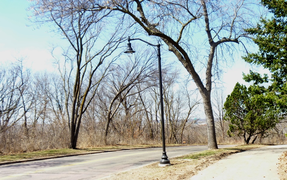
Fill in some leaves and there’s no view at all. Might as well be Deming Flats.
The park board has wonderful gardeners and foresters. They could make this view spectacular. Let’s let them. Something worthy of Portius C. Deming. If they need a hand clearing brush, I’ll help. My tribute to Mr. Deming.
David C. Smith
© David C. Smith 2013
Friday Photo: Before the Mills Were Ruins
Filed under: Mill Ruins Park, Minneapolis Parks: General, Mississippi River | Tags: Mill Ruins Park, Mississippi River, Stone Arch Bridge
Comments (8) Let’s go down to the river one more time. I have many favorite pictures of the riverfront when it was the economic engine of Minneapolis, but this is probably at the top of my list.

The west bank of the Mississippi River in downtown Minneapolis, just below St. Anthony Falls, in 1885. (Minnesota Historical Society)
You can see just a dash of the still-new Stone Arch Bridge on the right margin of the photo. The channel here is all tail race — the water that ran out of the mills after generating power.
My favorite part of this photo though is the trestle and railroad tracks that ran between the mills and the river at essentially the level of city streets. Those tail races coming out of the mills are now a part of Mill Ruins Park. The trestle and tracks are gone, but I don’t know when they were torn down. Anybody?
Below are two shots (a 3-for-1 Friday Photo!, the biggest Friday Photo discount ever) of the tail races as they appeared probably in the 1950s.

Tail races, some of which are now visible in Mill Ruins Park. (MPRB)

A closer look at the trail races and water returning to the river after its work was done. (MPRB)
Both photos are undated. They show the water coming out of the tail races. They give a much better sense of the management of water power. I’m not sure of the functions of structures and workers at this point in the water power process.
These structures were razed and covered when the Upper St. Anthony Falls Lock and Dam was built in the 1960s.
For a marvelous 360-degree panorama of Mill Ruins Park and the adjacent lock and dam go here, courtesy of the National Park Service. Learn much more about the lock and dam — one of the biggest mistakes Minneapolis and the U. S. Army Corps of Engineers ever made — at the pages of the Mississippi National River and Recreation Area.
Have a look around the park — if spring ever comes. The transformation is amazing — and thought-provoking.
David C. Smith
© Copyright 2013
Friday Photo: West Riverbank from the Stone Arch Bridge
Filed under: Mill Ruins Park, Minneapolis Parks: General | Tags: Mill Ruins Park, Stone Arch Bridge
Leave a Comment I don’t want to overdo the Stone Arch Bridge, but will run that risk with this photo found by Andrew Caddock at the park board. I showed the picture recently to a group of local history buffs and asked for guesses on when it was taken. Guesses ranged mostly from 1930-1960s. The real answer is ….
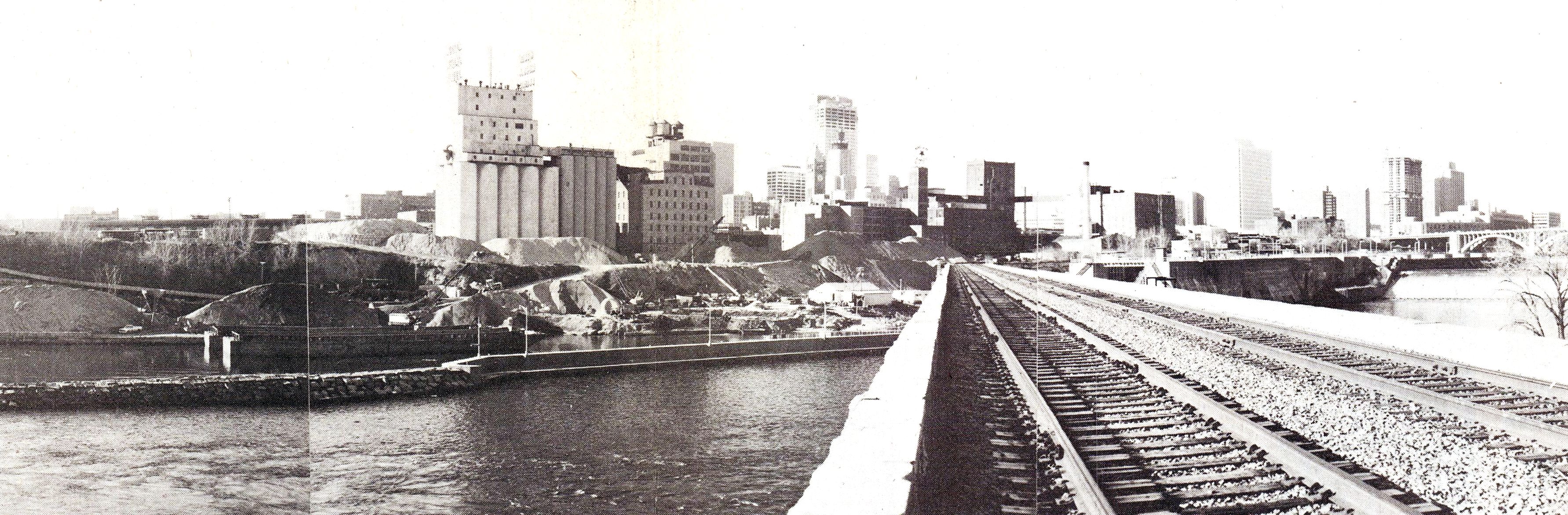
View from the Stone Arch Bridge. Click for larger image. (Jim Keane, Riverfront News)
…1980. Not that long ago.
The piles of sand and aggregate in front of the old mills were used to make concrete and were owned by Shiely Co. The materials were mixed on site and used in downtown construction projects; the sand and gravel could be transported at much lower cost by barge than by truck. The company first used the area for aggregate storage when it was making the concrete to build the upper lock and dam — on the right of the bridge — which was completed in 1965. Train traffic on the Stone Arch Bridge had stopped a couple of years before this photo was taken.
The photo appeared in the December 1980 issue of Riverfront News, a publication of the Minneapolis Riverfront Coordination Board, which included representatives of the major agencies of Minneapolis government.
The land under the sand piles is now Mill Ruins Park. The Guthrie Theater would be near the left edge of the photo
David C. Smith
Sisters of Chuckie: Powderhorn Park 1926
Filed under: Minneapolis Parks: General, Powderhorn Park | Tags: Doll Parades, Powderhorn Park
Comments (3) How did the cherished toys of one generation become scary to their great-grandchildren?
This photo raises the question. Doll buggy parades were big events at parks decades ago, especially in the 1930s. I’ve seen several photos of such events, some as recent as the 1970s. Yet, I’ve seen girls of today react very negatively to pictures of old dolls like these. They find them creepy. But aren’t these dolls more realistic and less creepy than many of the “fashion” dolls that girls play with now?

Dolls on parade at Powderhorn Park, 1926 (Minneapolis Park and Recreation Board)
Cool buggies, too. But with no children in sight? Yeah, they really are kinda creepy. The dolls look better with kids in the picture.

This Minneapolis Tribune photo from 1934, which includes girls from an unidentified park, is more appealing. (Minneapolis Photo Collection, Hennepin County Library)
Do you remember these events? Do you still have the dolls?
David C. Smith
Theodore Wirth, Francis Gross and Me: A Friday Photo and a Re-assessment
Filed under: Minneapolis Park Hero, Minneapolis parks | Tags: Francis A. Gross, Hubert H. Humphrey, Lyndale Park, Theodore Wirth
Comments (2) 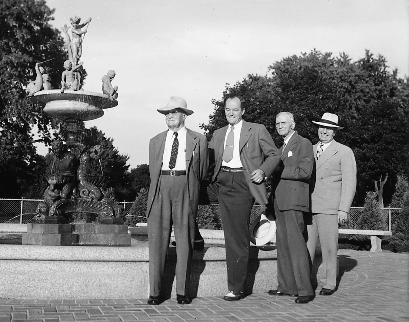
The dedication of Heffelfinger Fountain in Lyndale Park, 1947. This is the only photo I’ve seen of Theodore Wirth and Francis Gross together. They are joined by an even better-known Minneapolitan. From left: Park Superintendent Emeritus Theodore Wirth, Minneapolis Mayor Hubert H. Humphrey, Park Board President Francis A. Gross, Park Superintendent Charles E. Doell. Wirth was then 84 and Gross 77. The fountain had been discovered and purchased in Italy by Frank Heffelfinger, shipped to Minneapolis, and given to the park board. (Minneapolis Park and Recreation Board)
As I began my initial, intensive assault on Minneapolis park history in 2007 to write City of Parks, I was inclined to attribute the great success of our park system to Theodore Wirth — as so many people do. I had heard his name—attached as it was to a park, lake and parkway — for many years, and I promptly read his book on the park system—part history, part memoir.
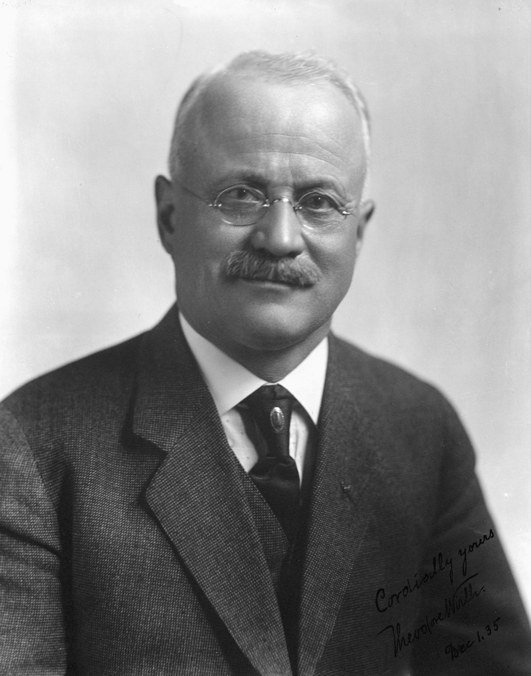
Theodore Wirth was superintendent of Minneapolis parks for 30 years, 1906-1935. (Minneapolis Park and Recreation Board)
It was the beginning of an up-and-down ride for me with Mr. Wirth and his legacy, one that I am reexamining in light of comments by Francis Gross in the autobiography he wrote in 1938.
I knew little about Wirth in 2007, but I did recall vividly being introduced to a Swedish gentleman at a party in Stockholm, Sweden in 1986 who, when he learned where I was from, gushed about what a great park planner Theodore Wirth had been. He knew much more about Wirth than I did and …Read more about how Francis Gross convinced me that Theodore Wirth was a good guy
Highlights, Lowlights and Unsolved Mysteries: 130 Years of Parks in Minneapolis
Celebrate the 130th birthday of the Minneapolis park system with me and the Linden Hills History Study Group, April 4, 7 p.m. at St. John’s Episcopal Church, 4201 Sheridan Avenue South. A $3 donation is suggested for those who aren’t members of the study group.
I’ll talk about the greatest accomplishments and most puzzling failures in Minneapolis parks since the Minneapolis Board of Park Commissioners was created by the Minnesota legislature and approved by Minneapolis voters on April 3, 1883. I’ll touch on many of the people, places and policies that have contributed to the fabulous park system we enjoy today — and I’ll also mention a few parks that might have been.
I hope you’ll join us.
David C. Smith

 Minneapolis Park History