The Myth of Bassett’s Creek
Filed under: Minneapolis parks, Mississippi River | Tags: Bassett's Creek, H.W.S. Cleveland, Horace Cleveland, Minnehaha Creek, Mississippi River
 Comments (24)
 I heard again recently the old complaint that north Minneapolis would be a different place if Bassett’s Creek had gotten the same treatment as Minnehaha Creek. Another story of neglect. Another myth.
You can find extensive information on the history of Bassett’s Creek online: a thorough account of the archeology of the area surrounding Bassett’s Creek near the Mississippi River by Scott Anfinson at From Site to Story — must reading for anyone who has even a passing interest in Mississippi River history; a more recent account of the region in a very good article by Meleah Maynard in City Pages in 2000; and, the creek’s greatest advocate, Dave Stack, provides info on the creek at the Friends of Bassett Creek , as well as updates on a Yahoo group site. Follow the links from the “Friends” site for more detailed information from the city and other sources.
What none of those provided to my satisfaction, however, was perspective on Bassett’s Creek itself after European settlement. A search of Minneapolis Tribune articles and Minneapolis City Council Proceedings, added to other sources, provides a clearer picture of the degree of degradation of Bassett’s Creek — mostly in the context of discussions of the city’s water supply. This was several years before the creation of the Minneapolis Board of Park Commissioners in 1883 — a time when Minnehaha Creek was still two miles outside of Minneapolis city limits. The region around the mouth of Bassett’s Creek was an economic powerhouse and an environmental disaster at a very early date — a mix that has never worked well for park acquisition and development.

Idyllic Minnehaha Creek, still in rural surroundings around 1900, quite a different setting than Bassett’s Creek, which had already been partly covered over by then. (Minnesota Historical Society)
“A Lady Precipitated from Bassett’s Creek Bridge”
Anfinson provides many details of the industrial development of the area around the mouth of Bassett’s Creek from shortly after Joel Bean Bassett built his first farm at the junction of the river and the creek in 1852. By the time the Minneapolis Tribune came into existence in 1867, industry was already well established near the banks of the creek. A June 1867 article relates how the three-story North Star Shingle Mill had been erected earlier that year near the creek. The next March an article related the decision to build a new steam-powered linseed oil plant near the creek on Washington Avenue.
Even more informative is a June 27, 1868 story about an elderly woman who fell from a wagon off the First Street bridge over the creek. “A Lady Precipitated from Bassett’s Creek Bridge, a Distance of Thirty Feet,” was the actual headline. (I’m a little embarrassed that I laughed at the odd headline, which evoked an image of old ladies raining down on the city; sadly, her injuries were feared to be fatal.) But a bridge height of thirty feet? That’s no piddling creek — even if a headline writer may have exaggerated a bit. The article was written from the perspective that the bridge was worn out and dangerous and should have been replaced when the city council had considered the matter a year earlier. Read more »
Horace Cleveland’s Friends: Five of Clubs
Filed under: Landscape Architects, Longfellow Field Park, Minneapolis Parks: General | Tags: Cornelius C. Felton, Five of Clubs, George Stillman Hillard, H.W.S. Cleveland, Henry Russell Cleveland, Henry Wadsworth Longfellow, Horace Cleveland, Longfellow Park, Sumner Field
Comments (1) Trivia to delight and amaze.
Can you name two Minneapolis parks named for members of the “Five of Clubs,” an informal sort of book club?
The “Five of Clubs” met informally at the suburban Boston home of Horace W. S. Cleveland’s brother, Henry, in the early 1840s. Horace lived with his older brother for a time and sat in on those “club” gatherings.
Answer: Sumner Field and Longfellow Field.
Sumner Field was named for Sumner Place, the street in north Minneapolis on which the park was built in 1911. Sumner Place was named for U. S. Senator Charles Sumner, famous for his opposition to slavery and for ensuring the rights of freed slaves during Reconstruction. Before he was elected to the Senate from Massachusetts, he was an attorney in Boston — and a member of the “Five of Clubs.”

Longfellow statue in a field near Longfellow Garden upstream from Minnehaha Falls, 2011. (Ursula Murray Husted, flickr.com)
Longfellow Field was named for Henry Wadsworth Longfellow, the poet and professor of modern languages at Harvard in the 1840s and also a member of the “Five of Clubs.” In 1855, Longfellow published his epic poem “Song of Hiawatha,” which made Minnehaha Falls famous around the world. Longfellow never visited Minnehaha Falls and the book was written 17 years before Horace Cleveland first saw the Falls.
Imagine Horace Cleveland’s astonishment if he would have been told that 110 years after his death he would be more respected in his field than Longfellow is in his.
The other members of the “Five of Clubs” were Cornelius C. Felton, professor and future president of Harvard University, and George Stillman Hillard, Sumner’s law partner and author and publisher.
A reminder: Minneapolis should have a park along the Mississippi River gorge named for Horace Cleveland.
For much, much more on Horace Cleveland, click on his name in the tag cloud at right. For the whole story of Horace Cleveland and Minneapolis parks read City of Parks.
Just curious. Any future Sumners or Longfellows or Clevelands in your book club?
David C. Smith
Talmud Torahs vs. Swastikas
Filed under: Minneapolis parks | Tags: Football, Sumner Field, Talmud Torah
Leave a Comment The combination of words was eye-catching. And image-generating: holocaust, horrors. But on the sports pages of the Minneapolis Tribune? In 1921?
There they were, two teams competing in the 125-pound division of the Minneapolis Amateur Football Association: the Swastikas and the Talmud Torahs. But this was before the Nazis stigmatized the swastika, which had Sanskrit origins and had been used around the globe for millenia as a symbol of good luck or success. It was a good word, a positive symbol. It was only a year earlier that the German National Socialist Party had adopted the swastika as its symbol and it would be nine years more until Adolph Hitler created the famous red, white and black swastika flag.
I haven’t been able to find any information on who sponsored the Swastika team or what part of the city they came from. I know more about the Talmud Torah teams. The Talmud Torah was a Hebrew free school, established in 1893, that instructed Jewish children in Hebrew language and literature and the history and traditions of the Jewish people. Students attended the Talmud Torah after their regular day of study at public schools.

Talmud Torah, 725 Fremont Avenue North, ca. 1950, sponsored sports teams in park recreation leagues beginning in 1919. (Minneapolis Star Journal Tribune, Minnesota Historical Society)
In 1915 a new Talmud Torah opened on Fremont and Eighth Avenue North. The original Talmud Torah had been supported by the Keneseth Israel congregation, but the school in the new building had a wider base of support than a single congregation. According to an article in the Minneapolis Tribune, January 10, 1915, the school “will make Minneapolis famous as the only city in which practically all the people of the Jewish race have united in providing an institute … for Jews of any language and social condition.”
The first sports score I can find for the Talmud Torahs was a basketball victory at their gym in December 20, 1919, when they defeated the Eagle A. C. 56-4. Nice debut. (Minneapolis Tribune, December 21, 1919.) But the Talmud Torahs — that’s what newspapers called them, just as they referred to the “Bottineaus” or “Powderhorns” for teams representing those parks — showed up in the sports pages of the Tribune especially during the football season. That was presaged perhaps by an article in the Minneapolis Tribune, November 28, 1915, which announced that the Newsboys Club of some 300 boys “accustomed to the life of the streets” had been taken under the wing of the social settlement house also established at Talmud Torah and that they would be instructed by University students that were “expert in football.” Those newsboys may have been the foundation for later Talmud Torah teams. Perhaps the most famous newsboy of that neighborhood is Sid Hartman of the StarTribune sports page, although he isn’t quite old enough to have been in the club at that date.
The home football field of the Talmud Torah teams was Sumner Field, just two blocks east of the school on Eighth. The school sponsored one to three teams each year in the early 1920s.
The weight divisions in those days were determined quite differently from today, when most restrictions on youth football are based on a weight limit. Only players under a certain weight are allowed to play in that league. It was different in the late 1910s and 1920s. Then each team registered with 16 players on its roster. The players were weighed and the average weight of those players determined the league they played in. Leagues ranged from 95 or 100 pounds to 140 pounds. increasing in 5 or 10 pound increments, with a “senior” division in which weight did not matter. Also interesting is that the weight classes applied without apparent regard to age. For example, an article in the Tribune about a 135-pound league game in 1921 noted that the match-up featured several former All-City high school stars.
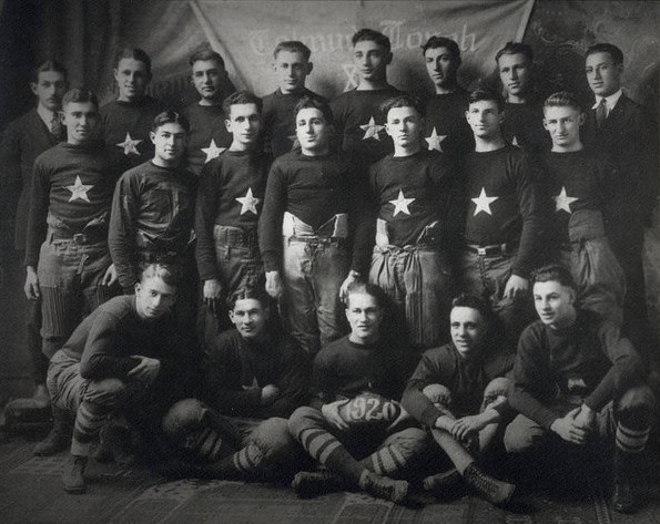
The first Talmud Torah football team, 1920 (Jewish Historical Society of the Upper Midwest, jhsum.com)
In 1920 the Talmud Torah team played in the 140-pound league and deep into the season was undefeated and unscored upon. In 1921 Talmud Torah had two teams, one played in the 125-pound league with the Swastikas — and won their division, a playoff with the winner of the other 125-pound division was snowed out — and the Talmud Torah Cubs played in the 100-pound league. The next year Talmud Torah sponsored three teams, one each in the 130-, 100- and 90-pound divisions.

In 1922, the Talmud Torahs were joined in park football by another Jewish team from the Judea A.C. Later Judea football teams were sponsored by the Emmanuel Cohen Center, a social service center established in 1924. The first Judeas team played in the 90-pound division — along with a Talmud Torah team — which is not likely the weight classification in which these fellows played.
The Rise of Activities Councils
If you happen by a soccer field in the fall or a park gym in winter now you’ll see nearly every team in uniforms with a name that ends in AC. Whether the uniform says WESAC, MFAC, SWAC, SIBAC, or something else, the AC stands for “activities council.” Activities councils — call them boosters or volunteers — associated with parks are a phenomenon that began with the creation of the Minnehaha Falls Activities Council (MFAC) serving Keewaydin Park in 1936. In the booklet, “Recommended Procedures for Park Area Recreation Councils” published by the park board in 1971, Robert Ruhe, park superintendent at the time, wrote that the councils were to his knowledge “unique among park and recreation departments in the United States.” The councils were and are independent of the park board recreation staff but work closely together to finance teams, buy equipment and provide coaches. The 1971 document lists the creation dates of 27 activities councils, many of which still exist.
While MFAC was the first booster club that promoted activities park wide, the idea of booster clubs was given a boost itself in 1951 and 1952 when new playgrounds were opened at Waite Park and Armatage respectively. Both school/park combinations were joint projects of the park board and the school board from the ground up. New parks were fertile ground for booster clubs and one was created at both parks. They were soon followed by the Southwest Activites Council (SWAC) in 1953 that covered two parks: Pershing and Linden Hills. SWAC was one of the most successful booster groups, providing a model for other parks. Two early activists in SWAC later became park commissioners, Inez Crimmins and Leonard Neiman, for whom the sports complex at Fort Snelling is named.
The booster clubs organized by park gradually replaced the more loosely managed efforts of players or businesses to put togther teams and secure equipment and create schedules. The job of organizing teams was more complicated then also because park recreation centers, other than the Logan Park Fieldhouse, were open and staffed only in the summer. There was no such thing as a year-round playground staff or recreation supervisors
For more photos and information about 1920s park football see this story about the football team from Bottineau.

This Camden team won the 1922 senior or open division of the Minneapolis Amateur Football Association managed by the park board recreation department.
David C. Smith
© David C. Smith
Northeast River Parks
Filed under: Minneapolis parks, Mississippi River | Tags: Edgewater Park, Gluek Park, Horace Cleveland, Mississippi River
Comments (4) I enjoyed a walk yesterday along the riverfront parks in northeast Minneapolis sponsored by the Minneapolis Riverfront Partnership. I told a few historical stories and park commissioner Liz Wielinski, Above the Falls committee member Mary Jamin Maguire, and Cordelia Pierson, executive director of the partnership, provided insights into park developments, past and future, along the river. We were also delighted to hear stories of the neighborhood from a few longtime residents of the area.
We visited Marshall Terrace, Edgewater Park, and Gluek Park and along the way we passed the newest, still unnamed, Minneapolis park at 2220 Marshall Street—a single lot from Marshall to the river purchased by the park board in 2010.
These are a few of the notes I made for my input into the program.
Marshall Terrace
Marshall Terrace was purchased in 1914. The first land chosen for a First Ward Park was a few blocks farther upriver, but neighborhood objections resulted in the park board asking for suggestions from residents and politicians for a better site. This eight-acre parcel further downriver was the result. (The park board also acquired the upriver acreage, but as a segment of a planned parkway across northeast Minneapolis, now St. Anthony Parkway, instead of a playground park.)
Park superintendent Theodore Wirth prepared these two plans for the new park, which were included in the 1915 Annual Report. (The same report included plans for nearby Bottineau Park.) Read more »
City Ordinance Restricts Building Height Around Minneapolis Lakes
Filed under: Minneapolis Parks: General | Tags: Gates Mansion, Lake Calhoun, Lake of the Isles, Loring Park, Washburn Fair Oaks
Comments (1) If you’re a long-time follower of Minneapolis politics, you might think this headline came from the 1988 fight to prevent a high-rise building from being constructed next to the Calhoun Beach Club facing Lake Calhoun. But you have to go back much farther in history to get to the first city ordinance to restrict construction on parkways encircling Minneapolis lakes.
I wrote a few weeks ago about Theodore Wirth’s description of the Calhoun Beach Club as a “disfigurement.” In that post I noted that Charles Loring was the first to warn the park board of the likelihood of commercial encroachment on the lake following the highly successful opening of the Lake Calhoun Bath House in July, 1912. Loring urged the park board to acquire the property across Lake Street from the bath house to prevent commercial development there. The fear, I’m sure, was the opening of saloons or dance halls. (Just two years earlier, in June 1910, the park board expanded Riverside Park when a dance hall was planned for land facing the park. The board preempted the dance hall plans by acquiring the land through condemnation.)
Since I wrote that post I’ve learned that by the time Loring made his suggestion in August 1912, the city had already passed an ordinance limiting construction on parkways around the lakes. And it had nothing to do with the Lake Calhoun Bath House. The purpose of the ordinance was essentially to facilitate the construction of this castle. Read more »
Nearby Parks: Landscape architect Arthur Nichols and park fireplaces
Filed under: Landscape Architects, Minneapolis parks | Tags: Arthur Nichols
Comments (2) This is not about Minneapolis parks, but let’s not be parochial. These coincidences are too good to pass up—and they are little more than a stones throw from Minneapolis.
I recently came across more information on Arthur Nichols, a Minneapolis landscape architect I had written about here and another notable park fireplace: the Beehive in St. Louis Park.

Read more about this “beehive” fireplace at slphistory.org or follow the link at right.
Nichols designed a series of roadside parks along Highway 100 from St. Louis Park to Robbinsdale when Highway 100 was constructed in the late 1930s. Read more about those mostly paved-over parks at the website of the St. Louis Park Historical Society here.
The beehive fireplace is of interest not only because it’s a cool design that could accommodate three picnicking families at a time, but because it is similar in several ways to the Minnehaha Park incinerator I wrote about a few days ago. Like the incinerator it was built in 1939. The slphistory web page claims it was built by unemployed masons, which I assume means it was part of a government relief work program, much like the WPA which was responsible for the Minnehaha incinerator. The beehive and incinerator were also both made of locally quarried limestone, the beehive limestone from the Minnesota River bluffs near the Mendota Bridge and the incinerator limestone from at or near Minnehaha Park which is only a couple miles north.
What I have yet to learn is whether Arthur Nichols designed the beehive fireplace himself or just specified it in his park plans. If anybody knows, please fill us in.
David C. Smith
Another Colorful Name Lost
Filed under: Minneapolis Park Names, Minneapolis Parks: General | Tags: Birch Pond, Glenwood Park, Theodore Wirth Park
Comments (3) The official record of the Minneapolis park board, the published “proceedings,” often don’t tell the whole story. Example: the proceedings of the park board meeting of June 6, 1910 record that the board voted that the “small lake in Glenwood Park between Western Avenue and Superior Avenue” be named “Birch Pond.” That’s been the name ever since.

What the official proceedings didn’t tell us I learned by accident while researching another issue. The June 7, 1910 Minneapolis Tribune noted the previous name of Birch Pond — the vastly more intriguing “Devil’s Glen.” I wonder how the little lake got that name. Probably a good story. But I imagine it was more offensive to some people than a lake named for John C. Calhoun.
The pond was renamed as the parkway beside it was being built by a crew of forty railroad workers imported from Hungary. The previous year, scheduled construction at North Commons and East River Parkway was postponed due to a labor shortage in Minneapolis. The park board took no chance with its new parkway through what was then Glenwood Park, now Theodore Wirth Park, and imported the workers to build it.
David C. Smith
Minnehaha Park: The Incinerator and the Fireplace
Filed under: Minneapolis parks, Minnehaha Falls, Mississippi River | Tags: Minnehaha Falls, Minnehaha Park
Comments (13) A few months ago Mary MacDonald and Doug Rosenquist asked about fireplaces near 54th and Hiawatha in Minnehaha Park. Mary asked about the stone fireplace a few hundred yards down the path into the dog park and Doug asked about the brick fireplace nearer the road and north of 54th Street.

View of the fireplace from the path in the dog park.
Unfortunately I haven’t found any information on the massive stone fireplace. Not even MaryLynn Pulscher of the park board knows why it’s there or who built it—and if MaryLynn doesn’t know it’s a decent bet that no one does. Still, I’ll keep asking around. I hope one of our readers knows somebody who remembers something and can pass it along to the rest of us.
I have better news about the two-story incinerator. It was built in 1939 by a WPA crew. This is how it was described in the park board’s 1939 annual report:
“Along this roadway a concrete, limestone-faced incinerator was constructed at the old stone quarry site. This incinerator, the first of its kind in our park system, will burn the waste accumulated from the various picnic grounds in this section of the city. A continuation of improvements similar to these is contemplated for next year.”
Two photos of the incinerator are included in the 1939 annual report, but those photos would be hard to reproduce due to the low quality printing of the annual report that year. The 1931-1939 annual reports were not typeset and production values were low.

A stairway goes down behind the incinerator to a lower level where the fire could be stoked and ashes removed..
Despite a reputation for producing elegant and well-illustrated annual reports dating back to the earliest days of the park board (see praise for the park board’s annual reports from noted landscape architect Warren Manning here), the park board’s finances during the Great Depression would not allow anything above the barest minimum of expenditures on annual reports. I am still grateful, however, that photos were included in the reports during those lean depression years.
Until you can get to a library to find a copy of the report and see the original photos, I will provide this quick shot I took last week.
In materials and construction — concrete faced with limestone — the incinerator is similar to the other WPA construction projects in Minnehaha Park in 1939 and 1940, including bridges across Minnehaha Creek in the lower glen and retaining walls built along the creek. (You still have two days to vote for Minnehaha Park and Mill Ruins Park in the Partners in Preservation contest on facebook.)
The Old Stone Quarry Site
The most interesting part of the incinerator description, for me, is its location at the “old stone quarry site.” I remember seeing the photo below in the 1907 annual report and assumed that the quarry was in operation for several years. It appears that it was not. Read more »
Triangle Followup: Prospect Park, Laurel and Sibley Triangles
Filed under: Minneapolis Parks: General, Prospect Park, Sibley Field | Tags: Laurel Triangle, Prospect Park, Sibley Field, Sibley Triangle
Comments (3) Summer gardens are gone and I never got a good picture of another beautiful park triangle: Sibley Triangle located in northeast Minneapolis where Washington Street NE and Fifth Street NE meet. (For earlier posts on park triangles see this one on small triangles and this one on triangles in Prospect Park.) Every time I was in the neighborhood I was without camera, so if any readers have photos I’d like to post them. The garden is planted and maintained by volunteer Robin Russell, who has done a fantastic job. Sibley Triangle is another of Minneapolis’s six triangles that are listed as 0.01 acre. The park board acquired the little triangle from the city in 1920.
Like Sibley Field in south Minneapolis, it was named for Henry Hastings Sibley, but the triangle was named first. Apparently having a little street triangle named for Sibley did not sufficiently honor Minnesota’s first governor, so the larger neighborhood park was named for him too — three years later. (The larger park had previously been referred to as Cedar Avenue Heights Park. See more here.)
I was also informed by Michelle Kellogg of the park board that the volunteer who deserves the credit for maintaining the tranquil gem of Laurel Triangle in Bryn Mawr is Patty Wycoff. Thanks Patty!

Laurel Triangle 2011
Finally, I spent an enjoyable evening in July with the Prospect Park Garden Club at the home of Mary Alice Kopf talking about triangles and other parks in the neighborhood. Thanks to Julie Wallace who dug up the info from neighborhood association documents that Bedford Triangle and Clarence Triangle were altered in 1979. Bedford Triangle was obliterated and the street on one side of Clarence Triangle was removed so it now appears to be part of the yard on the northwest corner of the Bedford and Clarence intersection. The only thing that suggests it is not private property is a boulder on the corner — as in the other Prospect Park triangle parks. I learned that night that the boulders were unearthed during the construction of I-94 through the neighborhood.
David C. Smith
Letters from Theodore Wirth: Gardener Above All?
The letters Theodore Wirth wrote to his friends during his 1936 around-the-world voyage, which included a quote on the Calhoun Beach Club, reveal little about Minneapolis parks, but quite a bit about the man.
When Wirth retired as Minneapolis park superintendent in 1935—he was forced to retire due to civil service age rules—he travelled with his wife to Hawaii, Samoa—where he visited his son, a U. S. Navy officer—Fiji, New Zealand, Australia, South Africa, the Canary Islands, England and on to his boyhood home in Switzerland. Over the course of his travels he wrote ten “general letters” to his friends in Minneapolis. The first was dated December 15, 1935 from a ship sailing from Los Angeles to Honolulu and the last was dated September, 1936 from Winterthur, Switzerland, his home town.
As Wirth explained in General Letter No. 2:
There are so many of you back home that it is of course impossible for me to write to you all. Even if I could do so, it would mean that I would be writing on the same subject time and again. I bargained for a good solution of this problem with Mr. Bossen (his successor as park superintendent) and Miss Merkert (his secretary for many years) before we left home, and I am to write a general letter from time to time, which is to be typed and circulated as may be deemed advisable.
The very method of distributing his letters speaks to his Swiss efficiency, but the content of those letters reveals a good bit about the man as well. Most of his letters are inconsequential newsy travelogues, but I am struck that he was most passionate and enthusiastic about plants on many stops during his voyage.
From his first letter, when he wrote of visiting John McLaren, the famous superintendent of San Francisco parks, he singled out trees for comment. Of California’s Redwood State Park, which McLaren took him to visit, he wrote, “the big Redwood trees are worth a world’s trip to see.” It is the first of many references to the grand and unusual plant life he observed.
Of course he wrote also of parks, commenting on a new park being built in Honolulu, and city planning, noting that Adelaide, Australia was the best-planned city he’d ever seen or heard of. But many of his most detailed observations were about plants.
In New Zealand he makes note of the “elaborately planted” grounds at Lake Rotorua, the “gorgeous tree ferns” towering 50 feet above the undergrowth, even the high yields of New Zealand’s wheat farms.
Of a tour of Sydney’s botanical garden with the curator, he notes a fine specimen of Morton Bay Fig, Ficus Macrophylia with a crown 110 feet in diameter and begonias eight to ten feet tall, concluding “there is no end to what I could report along the lines of plant life here.” He writes that Sydney has much more land set aside for recreation and open space than Minneapolis—Australians are “enthusiastic devotees or every worth while sport”—but it is “sadly lacking” in street tree plantings.
Melbourne is “lavishly decorated with floral displays,” he writes, but he also recounts his travel to see gigantic gum (Eucalyptus) trees six to eight feet in diameter and 150 tall, a “truly majestic sight, not unlike our glorious Redwoods,” and notes that the tuberous begonias at the Fitzgerald Gardens there were the largest he had ever seen.
He writes with special enthusiasm about the bulb nurseries of Holland and how the bulbs were auctioned, mentioning that he had letters of introduction to three bulb-growers from his friend O. J. Olson, a St. Paul florist. He encouraged every florist to visit Holland in May.
Thank you, Sonia Abramson
Copies of the ten letters, 48 pages, Wirth sent to his friends were given to the park board in August 2011 by Ed Abramson. Ed’s aunt, Sonia Abramson, was an employee of the park board, working most of her life in administration. Sonia must have been among those who received copies of the letters after Miss Merkert typed them from Theodore Wirth’s handwritten originals. Ed and his sister-in-law, Cookie Abramson, discovered the letters after his aunt died in 1998 at age 93. Ed recalls that his aunt “loved doing what she did.” “She did a marvelous job for the city and the park board treated her well. It was a win-win,” he said.
Wirth makes two other references to things Minneapolis in his letters — in addition to his Calhoun Beach Club reference.
He provides this account of Pago Pago: “The Pago Pago harbor is not any larger than Lake Calhoun. Imagine the lake surrounded by abruptly-raising, densely wooded mountains from 1,700 to 2,200 feet high—absolutely landlocked—the entrance from the ocean not visible once you are in the harbor.”
He also notes that while sailing from Samoa to Fiji, one morning on deck he was “agreeably surprised” to run into Edward C. Gale, a prominent Minneapolis attorney, son of Samuel Gale and son-in-law of John Pillsbury. They travelled on the same ship until they reached Auckland, New Zealand.
Wirth’s ten letters conclude with a description of parks and playgrounds in Switzerland which suggests where Wirth’s views of parks originated. Among his observations:
“The forests of Switzerland are both the nation’s park and playground in the fullest sense of the word.”
“People flock to the woods singly and in droves to find their recreation.”
“The Swiss people are an exceedingly nature-loving nation — the natural scenic beauty of their homeland makes them so.”
“Playgrounds, as we so properly advocate, build and maintain in the States, are not as essential here in Switzerland.”
“The entire population is more or less self-taught in their practice of exercising, physical culture and body development.”
“Playground activities are managed by the school authorities.”
“Park construction and operation are better known here under the name of “Gardenbau” and the branch of government that has jurisdiction over all pertaining to it is the one of Horticulture.”
These claims tend to corroborate my impression that Wirth never quite understood the American affinity for organized ball games and competitive sports. While many, many neighborhood playgrounds were designed by Wirth, there was nearly always in his layouts a clash between his instinct to create gardens—at least visually pleasing spaces—and his recognition of the popular demand for playing fields.
Theodore Wirth accomplished many things as a park superintendent, but I believe, as these letters suggest, his first love was gardening and horticulture.
David C. Smith
Lake Calhoun Bath House and Calhoun Beach Club: From “Disfigurement” to National Register
Filed under: Minneapolis parks | Tags: Charles M. Loring, Lake Calhoun, Theodore Wirth
Comments (2) Charles Loring was the first to sound the alarm about businesses across Lake Street from the Lake Calhoun Bath House, but no one put the criticism so bluntly as Theodore Wirth.

The Calhoun Beach Club loomed over the beach and lake in 1940. The old three-level diving platform was a bit less timid than today’s rafts. (Minneapolis Tribune, Minnesota Historical Society)
Four days after the official dedication of the new bath house—with changing rooms, lockers and showers, not to mention $10,000 worth of sand on the new beach—Loring appeared in person at the August 5, 1912 meeting of the Board of Park Commissioners, a board he had once presided over, to plead for the park board to acquire the land across Lake Street from the beach before it became filled with “refreshment stands.” He wasn’t proposing a massive acquisition: the park board already owned Dean Parkway to the west and much of the land between Calhoun and Lake of the Isles to the east. Loring only wanted the board to buy the strip between Lake Street and the railroad tracks sandwiched between existing park lands.
It didn’t. Which gave rise to one of the most novel criticisms ever of a Minneapolis landscape. From one of the most unusual locations.
Writing from a ship sailing from Capetown, South Africa to the Canary Islands in 1936, Theodore Wirth wrote this about Durban, a South African city on the Indian Ocean (see Letters from Theodore post):
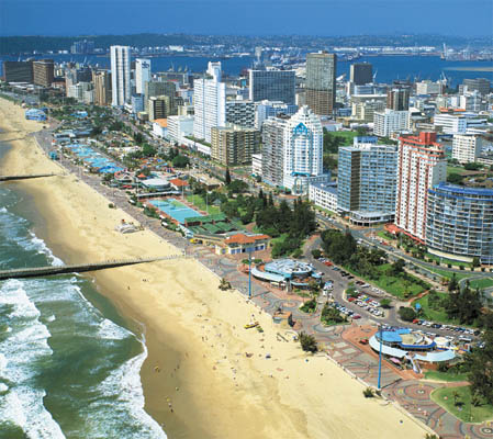
Modern Durban. The buildings might still be “monster rent barracks,” to use Wirth’s phrase, but the atmosphere at Durban’s beach has changed much more since 1936 than at Lake Calhoun. This photo looks nothing like what I remember from a visit in 1980.
Along the city side of the Durban Bay is the Marine Parade or Ocean Beach, flanked by a number of imposing modern buildings serving apartment and hotel purposes. The latter are called “flats” here and some of them are deserving of no better name, for they are anything but attractive. I am inclined to classify them as “monster rent barracks” — a still worse disfigurement of an otherwise attractive landscape than our Calhoun Beach Hotel at Dean Boulevard.
Theodore Wirth’s first opinion on the land across from the bath house was expressed in the 1912 annual report when he seconded the words of Loring and then board president Wilbur Decker encouraging the board to acquire the land to preserve it from commercial development.
Their fears may have been prompted by unpleasantness around Minnehaha Park in the early 1900s. Saloons and other commercial establishments near the falls had contributed to an objectionable environment in the park. In the 1905 annual report of the park board, president Fred Smith wrote that a new pavilion, changes in policing and support from the city administration had “done much to redeem Minnehaha from its unsavory reputation and make it a place where women and children can visit and enjoy their picnics without fear of molestation or insult.”
I can imagine that specter haunting Loring in particular, a man who had run for mayor of Minneapolis in 1882 on a strong anti-saloon platform. Loring also deserved most of the credit for the park board acquiring Minnehaha Falls, Lake Calhoun and Lake Harriet, the three jewels in the park crown at the time, and I’m sure he took a proprietary interest in their well-being, which would not have included “refreshment stands” nearby.
Despite their fears, the land across Lake Street from the immensely popular bath house — it was called the best beach between the oceans — was not filled with houses of debauchery. At least that’s the inference we can draw from another round of encouragement for the park board to acquire the land in 1917. Still it didn’t happen.
Another ten years passed before grand plans for the property took shape. It would become a residential building fitted with its own entertainment and recreation facilities. Curiously, the last mention of the development in park board proceedings is Wirth’s recommendation on April 20, 1927 that the board consent to a building permit for the facility as long as the building did not come within 15 feet of park property along Dean Parkway. The board agreed. Perhaps plans for the property were too far along for Wirth and the park board to fight, or they had no real alternative after taking no action themselves for 15 years
But perhaps Wirth’s objection in 1936 was not that the building was there, but that it was unfinished. Although construction began in 1927 the building remained unfinished and empty until 1946. In a bit of irony, the property Wirth worried would fall into private hands and the building which he said “disfigured” the lake was the site of a tribute dinner to him in 1946 before he moved from Minneapolis to San Diego for health reasons.
The Calhoun Beach Club was added to the National Register of Historic Places in 2003 for its architecture and engineering. The building now adjacent to the commercial and residential “club” was the focus of a fight in 1988 to limit the height of buildings around Minneapolis lakes. That battle resulted in a city ordinance that limits the height of such buildings. When the Calhoun Beach Club was first designed in 1927, at ten stories, it was the tallest building in the city outside of downtown.
David C. Smith
The Seven Squares
No one has answered correctly my challenge of a couple weeks ago to name the seven “squares” that are parks in the Minneapolis park system. The illion-dollar prize will, therefore, not be awarded, but perhaps will be rolled over into a new contest sometime in the future.
The seven Minneapolis park “squares” are Murphy Square, Jackson Square, Bryant Square, Franklin Steele Square, Stevens Square, Lovell Square and Chute Square.
Two squares were named only for the streets on which they are situated: Bryant Square in south Minneapolis and Jackson Square in northeast. Neither street name had anything to do with Minneapolis. William Cullen Bryant was a poet and Andrew Jackson was President of the US of A.
Perhaps it is coincidence, but the only two squares not named for local heroes were also the only of the seven that were used as garbage dumps.
In the case of Bryant Square it was with the blessing of the park board. The land for Bryant Square was well below street grade — 20 feet in some places — so before the park board agreed to buy the land for a park in 1904 it set the condition that no improvements would be made until the neighborhood filled the land. So the neighborhood dumped its garbage there. It wasn’t enough. Finally, after eight years, the park board spent $6,000 to purchase fill for the park. A few trees were planted and a bit of playground equipment was installed in 1913 and 1914. Drive past the park today and you will see that the playing fields are still below the grade of the streets around them. Bryant Square is the largest of the parks named squares at 3.66 acres.
Jackson Square’s use as a garbage dump was not so well received by the park board. Only a year after it was acquired in 1906, park superintendent Theodore Wirth requested permission to erect a fence around the still-unimproved park to prevent neighbors from dumping garbage there. But that’s not as sad as the naming of the park. Before the park board acquired the land and chose such a bland name, the block was referred to as Long John Pond. Long John Square: doesn’t that sound more fun? Years later the city realized that the old Long John Pond had once served a useful purpose and recreated a drainage pond in the block south of the park, across from Edison High School. It’s not named for Long John either. Anyone in the neighborhood want to start a campaign? Can anyone tell us the story of Long John?
Another square, Stevens, was also named for an adjacent street, but Col. John Stevens, for whom the street was named, was one of the pioneers of Minneapolis. His house, the first frame house on the Minneapolis side of St. Anthony Falls, now stands restored in Minnehaha Park. Stevens’ statue stands watch outside his old homestead. The statue was a gift to the city from his daughter Katharine Stevens Winston, whose husband, P. B. Winston, was once mayor of Minneapolis. The statue was placed in Stevens Circle, at Portland and Sixth Avenue South, in 1911. It lived there until that park was taken to widen streets in 1935. I think the statue should have been moved to Stevens Square, instead of Minnehaha.

Stevens Square in 1936. (Minnesota Historical Society)
If you’re looking for some fun, place the statue of Stevens below into the park above and see where it looks good. You might also tinker with the hat. When the Municipal Art Commission gave its approval to place the statue on public land, it recommended that in keeping with the “natural dignity” of the character, the hat be removed from the sculpture. The commission also recommended that the statue be given some architectural backdrop instead of being a free standing sculpture, probably something more like the Thomas Lowry monument built a few years later. Obviously neither recommendation was followed.

Stevens Statue at Portland and Sixth in 1912 shortly after it was installed. The park name was changed from Portland Triangle to Stevens Circle in honor of the event. Stevens was moved to Minnehaha Park in 1935 when the city needed this land to enlarge the street to accommodate more traffic. (Charles Hibbard, Minnesota Historical Society)
Murphy Square was the first park in Minneapolis, donated by Edward Murphy to the city in 1857. I’ve already written about Murphy Square here.
Like Murphy Square, Franklin Steele Square and Lovell Square were donated by the people or families whose names they carry. Franklin Steele Square was donated by the three daughters of Franklin Steele in 1882, a year before the Minneapolis Board of Park Commissioners was created. They donated the land on the condition that Charles Loring take charge of improving the park, which he agreed to do. (Loring had just lost his bid to become mayor of Minneapolis and the park board, of which he became the first president, had not yet been created, so he had some time on his hands — and he was well-known around the city for his interest in landscaping and horticulture.) Franklin Steele built the first bridge across the Mississippi River, among other notable pioneering achievements.
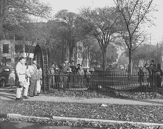
Looks like some sort of groundbreaking at Franklin Steele Square in 1947. In 1949 a new shelter was built at the park to serve also as a warming house for skaters in winter. (Minnesota Historical Society)
Seven years after Steele’s daughters donated land for the park, they were opponents of an effort to create another new park when the state of Minnesota purchased by condemnation the land for Minnehaha Park, which included the falls. Two of the daughters owned land taken at that time and appealed the case to the courts, where they lost. Franklin Steele Square, now hemmed in on two sides by freeways, is nothing like it once was. The freeways nipped 0.14 acres from the park in the 1960s.
Lovell Square in north Minneapolis was a gift to the park board in 1887 from C. P. Lovell, Elwood Corser and William Barnes, influential real estate developers in the city. The three also deeded the land for nearby Barnes Place. Elwood Corser had also donated land for Lake of the Isles Parkways. Corser and Barnes were often appointed by the park board as appraisers in land condemnation proceedings for parks.
Chute Square, the smallest of the squares at 1.1 acres, is the site of the Ard Godfrey House in old St. Anthony. It is named for Richard Chute an early landowner in St. Anthony. In an unusual twist, the square was named not for someone who donated land, but from whom some of the land was purchased. Richard and his brother Samuel, who served on the first park board, had owned some of the land that was converted into park in 1903. Surrounded now mostly by condos and townhouses, the square once had a more imposing neighbor, the Exposition Building.

The Exposition Center looms behind the Godfrey House in Chute Square in 1936. The Exposition Building was the site of the 1892 Republican Party national convention. (Minnesota Historical Society.)
The Hennepin County Historical Society proposed in 1955 to build a history museum on Chute Square, but the park board rejected the idea because the square was too small.
Over the years the Minneapolis park board has lost two squares, too. Market Square was given up to build the Exposition Center in 1886. Pioneer Square which occupied the land across from the downtown post office was taken over by the city in the 1960s as a part of urban renewal.
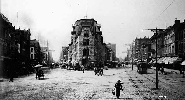
You’re looking across Bridge Square from the Hennepin Bridge to City Hall, the future location of The Gateway. Hennepin Avenue is on the right, Nicollet Avenue on the left in 1885. (Charles Hibbard, Minnesota historical Society)
Probably the most famous square in Minneapolis history, Bridge Square, at the intersection of Nicollet and Hennepin in front of the Hennepin Avenue Bridge — the hub of the city — was never a park, but the old Gateway park nosed up to it from the west on the City Hall site. The original Gateway was also demolished for urban renewal.
The Gateway was a big triangle and a big failure as a park. And it remains a cautionary tale for those who wish to create downtown parks.
Many other Minneapolis parks, in fact most neighborhood parks in the city, are in the shape of a square or rectangle, but for some reason only the seven parks above were named “squares.”
David C. Smith
 Minneapolis Park History