Archive for the ‘Minneapolis parks’ Category
Engineers in Minneapolis Park Plans
Filed under: Landscape Architects, Minneapolis parks | Tags: A.C. Godward, A.E. Berthe, Charles E. Doell, Frank Nutter, Minneapolis Landscape Architects, Theodore Wirth, W.E. Stoopes
 Comments (3)
 I was curious about the people who created the park plans I featured in the Catalog of Minneapolis Park Plans, 1906-1935, which was presented in three installments recently (Vol. 1, Vol. 2, Vol. 3). The catalog identifies all the plans and drawings published in Minneapolis park board annual reports during the tenure of Theodore Wirth as Minneapolis’s park superintendent.
I’ve tried to piece together info on the men whose names appear on those plans as engineers or delineators using park board reports, newspaper archives, and miscellaneous documents found through online searches. I’m not aware of any other background information at the park board on the early engineering and planning staff.

The park board engineering staff about 1915 in their 4th floor offices in City Hall. From left: Alfred C. Godward, Charles E. Doell, Clyde Peterson, Herman Olson, Dick Butler, “Spud” Huxtable, “Spike” Miller and Al Berthe. (Minneapolis Park and Recreation Board)
The man whose name appears on almost all of the plans, Theodore Wirth, superintendent of parks, is already well-known. Most of the others, much less so—although two of them, Charles Doell and Harold Lathrop, became very well-known nationally as park administrators.
During that time, the park board employed no “landscape architects.” The profession was still relatively new. The American Society of Landscape Architects (ASLA) was founded in 1898 and the first university programs in the field were created at Harvard and MIT around the turn of the century. This was after the first generation of true landscape architects in the United States, led by Frederick Law Olmsted and H W. S. Cleveland, had already passed from the scene. Cleveland had been the Minneapolis park board’s advisor and landscape architect from the creation of the park board in 1883, and had helped define the profession in this country. The park board had also hired landscape architect Warren Manning on a few occasions from 1899-1904 to provide advice and park plans after Cleveland retired.
Theodore Wirth was likely hired as park superintendent in Minneapolis in part because he had some experience designing parks in Hartford, Conn. He is credited with the designs of Colt and Elizabeth parks in Hartford. (Early in Wirth’s time in Hartford, the landscape architect role was filled by the Olmsted Brothers, the firm run by the sons of Frederick Law Olmsted. The senior Olmsted was a native of Hartford.) Wirth certainly played the role of landscape architect in Minneapolis, but I’m not aware of him ever calling himself one. He was active in the American Institute of Park Executives, and its predecessor organizations, but never ASLA. For ten years, 1925-1934, Wirth’s name appears on park plans as “Sup’t & Engineer” even though he did not have a formal engineering credential—apart from a course at a technical school in his native Switzerland as a young man. That course may have focused more on gardening than engineering. His first jobs were as a gardener. I could only guess at Wirth’s reasons for taking the “Engineer” title on park plans for the first time at age 62.
During his long tenure in Minneapolis, Wirth built a staff of men with Civil Engineering degrees—all from the University of Minnesota—not landscape architecture degrees or training. The first landscape architect hired full-time by the park board was Felix Dhainin in 1938. (If anyone could tell us more about Dhainin, I’d appreciate it.)
Here’s what I learned about the engineers for the park board 1906-1935. I’ll get to the draftsmen and delineators in a later post. Turns out the most interesting of all the park board engineers wasn’t featured in annual report plans at all! Read on
Those Darn Cars!
Filed under: Minneapolis parks | Tags: Charles M. Loring, Lake Harriet Pavilion
Comments (1) “It is the sense of this Board that the practice of tooting Automobile horns, by way of applause, at the concerts given in the parks should be discontinued.”
Motion proposed by park commissioner Charles M. Loring and adopted by the Minneapolis Board of Park Commissioners, June 18, 1906.
A Railroad Town
Filed under: Minneapolis parks, Mississippi River | Tags: Above The Falls, Mississippi River, Stone Arch Bridge
Comments (1) To reinforce recent articles that addressed the dominance of railroads and mills along the Minneapolis riverfront, I found these photos from about 1920 to be fascinating. Both are from the photo collection of the Minnesota Historical Society, a fabulous resource for understanding how our city and state came to be. The collection includes other aerial photos by Paul W. Hamilton of Minneapolis and St. Paul from the same time. They’re worth a look.

The west bank of the Mississippi River in Minneapolis looking downriver from above St. Anthony Falls. Nicollet Island is far left, the Stone Arch Bridge upper left in about 1921 (Paul W. Hamilton, Minnesota Historical Society)

North Minneapolis at Plymouth and Washington looking east toward the Mississippi River and Plymouth Bridge in background. Railroads consumed a lot of land in about 1920 on the west bank. (Paul W. Hamilton, Minnesota Historical Society)
When you look at these pictures it’s obvious why the Civic Commission and the park board were interested in reclaiming the riverfront 100 years ago.
David C. Smith
Bryn Mawr Golf Course Update
Filed under: Minneapolis Golf Courses, Minneapolis parks | Tags: Bryn Mawr, Golf, Interlachen Golf, Minikahda
Comments (2) I recently met with Joe Bissen who is writing a book on lost Minnesota golf courses. We walked around the Bryn Mawr neighborhood trying to determine the location of the old clubhouses of the Bryn Mawr Golf Course. The course, which existed from 1898 to 1911 near the Penn Avenue-Cedar Lake Road intersection, spawned both the Minikahda and Interlachen clubs before it closed and the course disappeared.

Golfing at Bryn Mawr in 1898. (Minnesota Historical Society)
The Bryn Mawr course had two clubhouses. The first was located at 95 Elm Street, now Morgan Avenue South, which had been a private residence of the Woodburn family before it was purchased in 1898 and converted into a clubhouse. The second clubhouse was built nearby. Bissen has found the address of the second clubhouse in 1908 to be 97 Oliver Avenue North.
Here’s the challenge. At that time Superior Avenue, what is now roughly I-394, was the dividing line between north and south street addresses, but now that dividing line is about a half-mile north at Chestnut Avenue. What was once Oliver Avenue North in Bryn Mawr is now Oliver Avenue South. Can anyone shed light on the present address of what was once 95 Oliver Avenue North? Joe and I suspect it was in the 400 or 600 block of what is now Oliver Avenue South. (Futher complicating addresses in the neighborhood there are no 500 addresses—straight from 490s to 600s!)
Can any Bryn Mawr historians solve this puzzle? Let me know and I’ll put you in touch with Joe. Would property abstracts show old addresses? And why (when) was Bryn Mawr moved from north to south?
Joe Bissen is researching lost golf courses throughout the state, so if you know of other courses, such as the Camden Golf Club in north Minneapolis, which disappeared with hardly a trace, Joe would like to know more about them.
David C. Smith
The First River Plans: Long Before “Above the Falls” and “RiverFirst”
Filed under: Minneapolis parks, Mississippi River | Tags: Above The Falls, Charles M. Loring, H. W. S. Cleveland, Hall's Island, Horace Cleveland, Mississippi River, RiverFIRST, St.Anthony Falls, William Watts Folwell
Comments (2) 
“I have been trying hard all Winter to save the river banks and have had some of the best men for backers, but Satan has beaten us.” H. W. S. Cleveland to Frederick Law Olmsted on efforts to have the banks of the Mississippi River in Minneapolis preserved as parkland, June 13, 1889 (Letter: Olmsted Papers, Library of Congress. Photo: H. W. S. Cleveland, undated, Ramsey County Historical Society)
Considerable time, effort and expense—$1.5 million spent or contractually committed to date—have been invested in the last two years to create “RiverFirst,” a new vision and plans for park development in Minneapolis along the Mississippi River above St. Anthony Falls. That’s in addition to the old vision and plans, which were actually called “Above the Falls” and haven’t been set aside either. If you’re confused, you’re not alone.
Efforts to “improve” the banks of the Mississippi River above the falls have a long and disappointing history. Despite the impression given since the riverfront design competition was announced in 2010, the river banks above the falls—the sinew of the early Minneapolis economy—have been given considerable attention at various times over the last 150 years. There’s much more
Pushball at Powderhorn
Filed under: Minneapolis parks | Tags: Powderhorn Park, pushball
Comments (2) Does anyone remember “pushball”? This photo was taken at Powderhorn Park, but the date isn’t marked. It looks like a fair number of kids were left standing and watching.
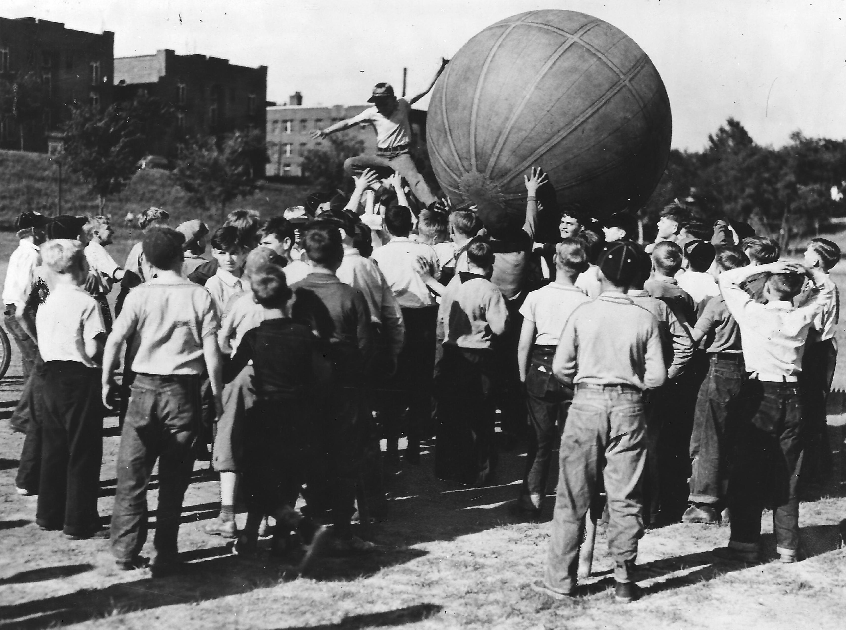
This is “Pushball.” The apartments in the background appear to be those on Powderhorn Terrace just north of the park. Date unknown. (Minneapolis Park and Recreation Board)
Any guesses on the date?
Do you remember any other playground games that aren’t played anymore? Got pictures?
David C. Smith
Low River Redux
Filed under: Minneapolis parks, Mississippi River | Tags: Ford Dam, Mississippi River, St.Anthony Falls, Stone Arch Bridge
Comments (2) The dry weather this year is evident on the Mississippi River at St. Anthony Falls. A couple weeks ago I posted an aerial photo of St. Anthony Falls when it was very dry in 1955. The water levels on the river appear to be similar now. Larry Dillehay sent this photo taken on the afternoon of October 2. The concrete apron at the Falls isn’t quite dry, but there’s not enough water flowing to make a ripple at the bottom. The horseshoe dam above the falls is now completely out of the water. What a gorgeous day—again.
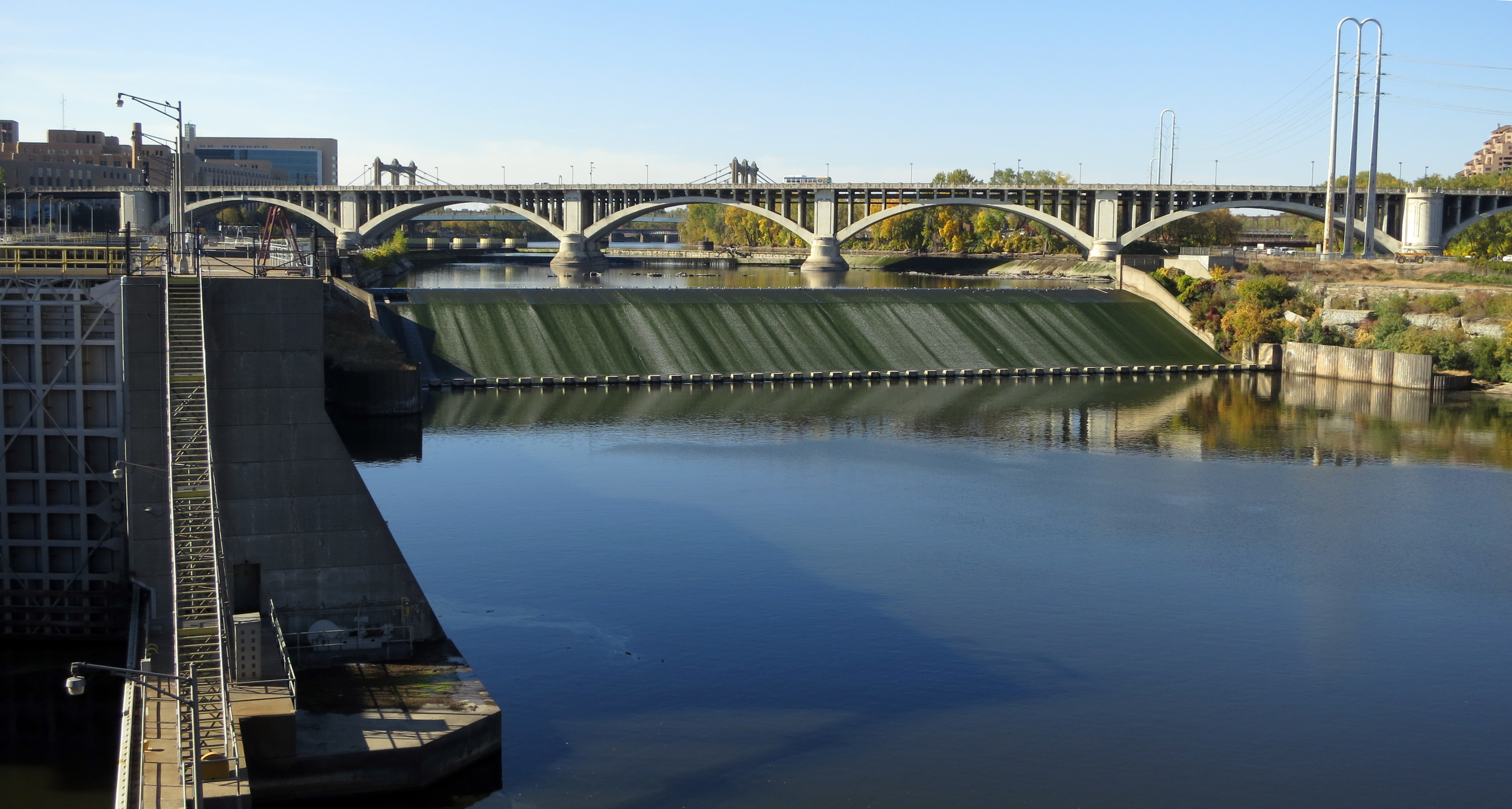
St. Anthony Falls in a very dry year, as seen from the Stone Arch Bridge, October 2, 2012. (Photo: Larry Dillehay)

Horseshoe dam exposed, with Nicollet Island in background. From 3rd Avenue Bridge just upriver from St. Anthony Falls, October 2, 2012 (Photo: Larry Dillehay)
David C. Smith
Postscript: Both the horseshoe dam and Lock and Dam #1, or Ford Dam, were repaired while the water was at this level, suggesting that while the summer had been very dry, the water levels had been lowered intentionally by the U.S. Army Corps of Engineers to facilitate mainteneance.
Catalog of Minneapolis Park Plans: Volume III, 1926-1935
Filed under: Landscape Architects, Minneapolis Park History Resources, Minneapolis parks | Tags: A.E. Berthe, Harold W. Lathrop, Minneapolis park designs, Theodore Wirth
Comments (2) The thirty annual reports produced while Theodore Wirth was superintendent of parks in Minneapolis—1906-1935—were rich in detail and illustrations. Those reports included 328 plans, designs and maps of parks and park structures. The publication of those plans usually coincided with the acquisition or development of new properties or the improvement of older ones, so they are a good guide to where to find some discussion of those park properties in annual reports or proceedings. So, long ago I catalogued all of those plans in one document to create a searchable guide to park development during those years. I have relied on that list for the last few years and assumed other researchers and park lovers would find it useful as well. I’ve already posted the first twenty years worth of plans, and today is Volume III, 1926-1935.

Detail of a plan published in the 1912 annual report showing a proposed canoe house on a peninsula in Lake Harriet. (1912 Annual Report, Minneapolis Board of Park Commissioners)
The plans published in annual reports were not the only plans created by the park board staff in the years Wirth was superintendent of parks. They are mostly conceptual plans, rather than working plans. The park board requested many of the plans specifically as park commissioners considered various park proposals and possibilities.
The number of employees in the park board’s engineering department are not published in every annual report, but in most years for which that info is provided, it appears that one or two draftsmen were employed. A few of their names appear as “Delineator” or “Del.” on the plans. Sometime in the near future, I’ll provide a guide to some of the names of the people who helped prepare plans.
The titles of the plans are verbatim as they appear on plans. I’ve also copied dates, names and titles as they appear, but have added some punctuation to make them easier to read. Parenthetical comments identify current park names or mention important plan elements.
The annual reports from 1931 to 1935 were not typeset in order to cut costs during the Depression. The reports also contained very few plans or illustrations, not just to reduce printing costs, but because the park board had no money to spend on improving parks. Continue reading
Catalog of Minneapolis Park Plans: Volume II, 1916-1925
Filed under: Landscape Architects, Minneapolis Park History Resources, Minneapolis parks | Tags: A.C. Godward, A.E. Berthe, Minneapolis park designs, Theodore Wirth
Comments (3) A few days ago I published the first installment (1906-1915) of a Catalog of Minneapolis Park Plans presented in the annual reports of the Minneapolis park board while Theodore Wirth was superintendent of Minneapolis parks (1906-1935). Today I publish the second installment of plans and drawings in annual reports covering 1916-1925.
Along with this “volume” I want to add a dedication and explanation: I am publishing this list of plans for anyone to use, like the rest of the research I have posted here, partly out of my interest in the subject and our civic history. But I also want to acknowledge former park superintendent Jon Gurban’s role in my research. When Jon informed me in early 2007 that I had been selected to write the history of the first 125 years of the Minneapolis Park and Recreation Board—the book City of Parks was the result—he had one request. He asked that, in addition to writing the book, I would share with park board staff and him other useful, important and interesting information that I uncovered in my research. While conducting research just to write my book proposal that winter, I had found several items that I had brought to his attention that I thought were fascinating. He said that my enthusiasm for those finds and my willingness to share them were factors in me getting the assignment.
So this Catalog of Minneapolis Park Plans is published with a nod to Jon Gurban, in my experience an honorable man treated dishonorably by some with whom he shared a passion for Minneapolis parks.

This plan for the Minnehaha Stone Quarry from the 1919 annual report is representative of the plans listed below. (Minneapolis Park and Recreation Board)
Remember that many of the plans presented in annual reports were conceptual plans and many were not implemented or were revised extensively. Most of the plans were created by park superintendent Theodore Wirth, with exceptions as noted. It would be a mistake, however, to assume because Wirth created the plans that the ideas for the parks also came from him. Some of the plans grew from Wirth’s own vision, while many other plans were requested by the park board or were concepts that had been bouncing around for some years.
This catalog will be most useful for park planners and historians, but also provides many insights into our park system for casual observers or fans of particular parks. After I publish the last third of the catalog (soon), I’ll provide a bit of information on the various individuals who are credited on these plans—as well as some others who weren’t given credit.
The titles of the plans are verbatim as they appear on plans. I’ve also copied dates, names and titles as they appear, but have added some punctuation to make them easier to read. Parenthetical comments identify current park names or mention important plan elements. /s/ indicates a signature.
A quick explanatory note: 1925 was the first year that Theodore Wirth added “engineer” to his title on park plans. That doesn’t indicate a new credential for Wirth, but the departure of A.C. Godward as the park board’s engineer. Godward had taken the job of Engineer for Minneapolis’s new City Planning Department in June 1922, but continued to supervise engineering at the park board, too. When Godward left the park board completely in 1925, his assistant, A. E. Berthe, kept the title Assistant Engineer and Wirth took the Engineer title himself. Despite Wirth’s praise for Berthe’s work, and Berthe being listed in annual reports as “head” of the engineering department, he remained the Asst Engr to Wirth until 1935, when Berthe was listed as Park Engineer or Civil Engineer and Wirth as General Superintendent.
Now That’s a Teeter Totter!
Filed under: Minneapolis parks | Tags: Brackett Park, playgrounds, teeter-totters
Comments (9) I don’t know where or when this photo was taken, but this is how they used to do it in Minneapolis parks. This is how above-average kids used to play. Kid-powered thrill rides provided the adrenaline rush. And there isn’t a single teeter-totter crash helmet in sight — unless that girl has padding in her bow.
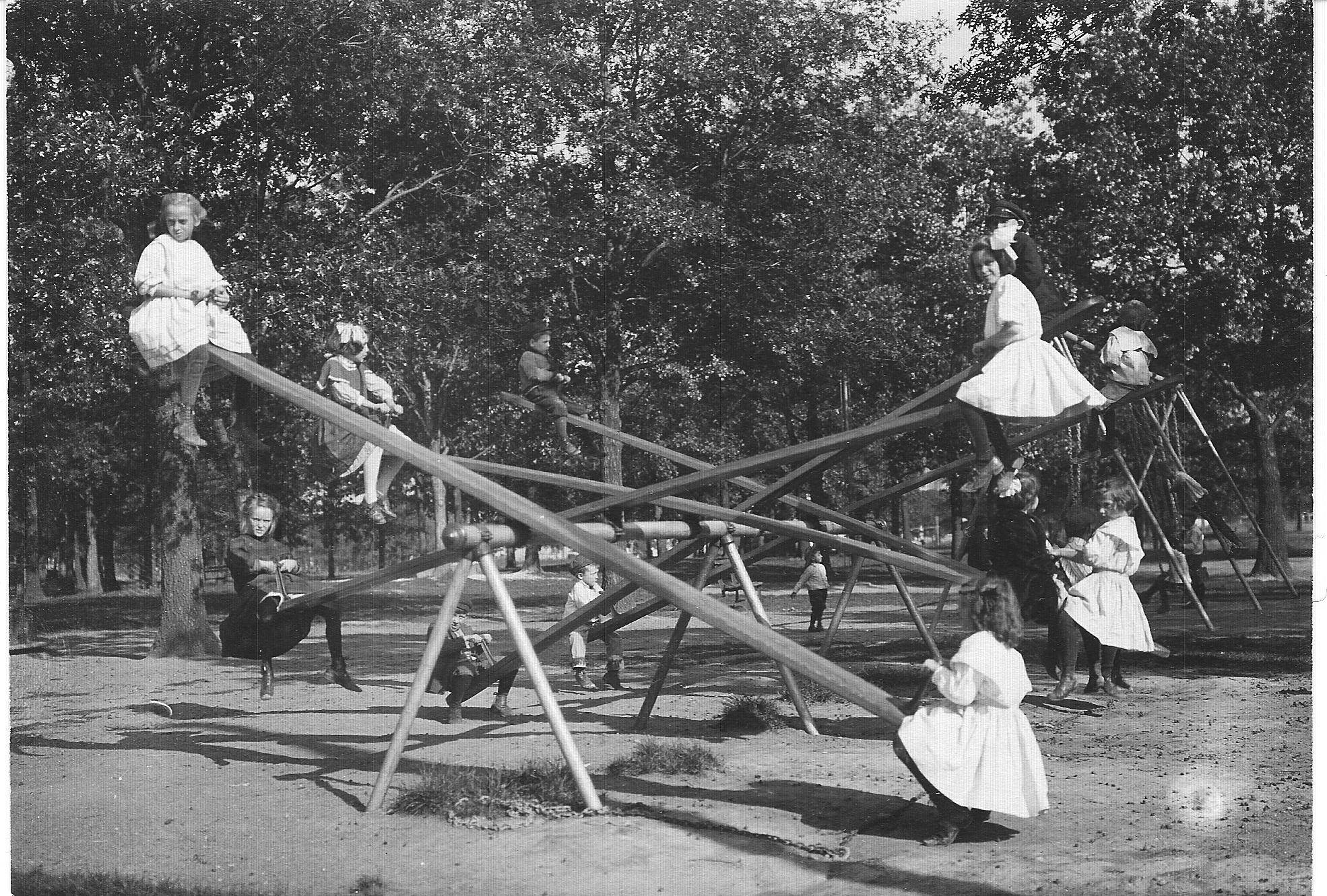
I’ve read every Attorney’s Report in park board annual reports, as well as all attorney reports in park board proceedings since 1904, when playground quipment was first installed in Minneapolis parks, and I don’t recall seeing even one report of a lawsuit over injuries on teeter-totters—or any other playground apparatus. Maybe there were no injuries and it was simply the fear of injuries that caused the teeter-totters to be taken down—or scaled down. It’s been years since I’ve seen one. Do they still exist?
Compare this to the two newest playgrounds in Minneapolis parks at Beard Plaisance and William Berry Park near the Lake Harriet Bandstand. Nice, and big improvements, but pretty tame. My favorite playground equipment is still the stuff at Brackett. First they had the Rocket, and now they have innovative equipment that’s quite unlike other parks.
More importantly, how did moms keep those dresses so white?
If you recognize the location above, or can guess the year, please send a note.
David C. Smith
Snowmobiles in Minneapolis Parks: 1967
Filed under: Minneapolis parks, Winter Sports | Tags: Boatel, Meadowbrook Golf Course, Ski-Bird, Snowmobiles, Theodore Wirth Lake, Trashmen
Comments (4) Do you remember snowmobiles in 1967? I remember them as loud, smelly, uncomfortable and, by today’s standards, horribly unwieldy. Not what you’d expect to find in pristine city parks. But they were very trendy then—the latest and coolest—and Minneapolis parks have always tried to keep up with what was new and in-demand in recreational opportunities. On December 13, 1967 the park board approved establishing a snowmobile course on Meadowbrook Golf Course and renting snowmobiles there.
My snowmobile memories were prompted by the park board’s current interest in allowing snowmobiles on Wirth Lake in Minneapolis as part of a snowmobile convention this winter. I found some 1967 photos of snowmobiles at Meadowbrook a while back and scanned them just because they represented a moment in time for me.
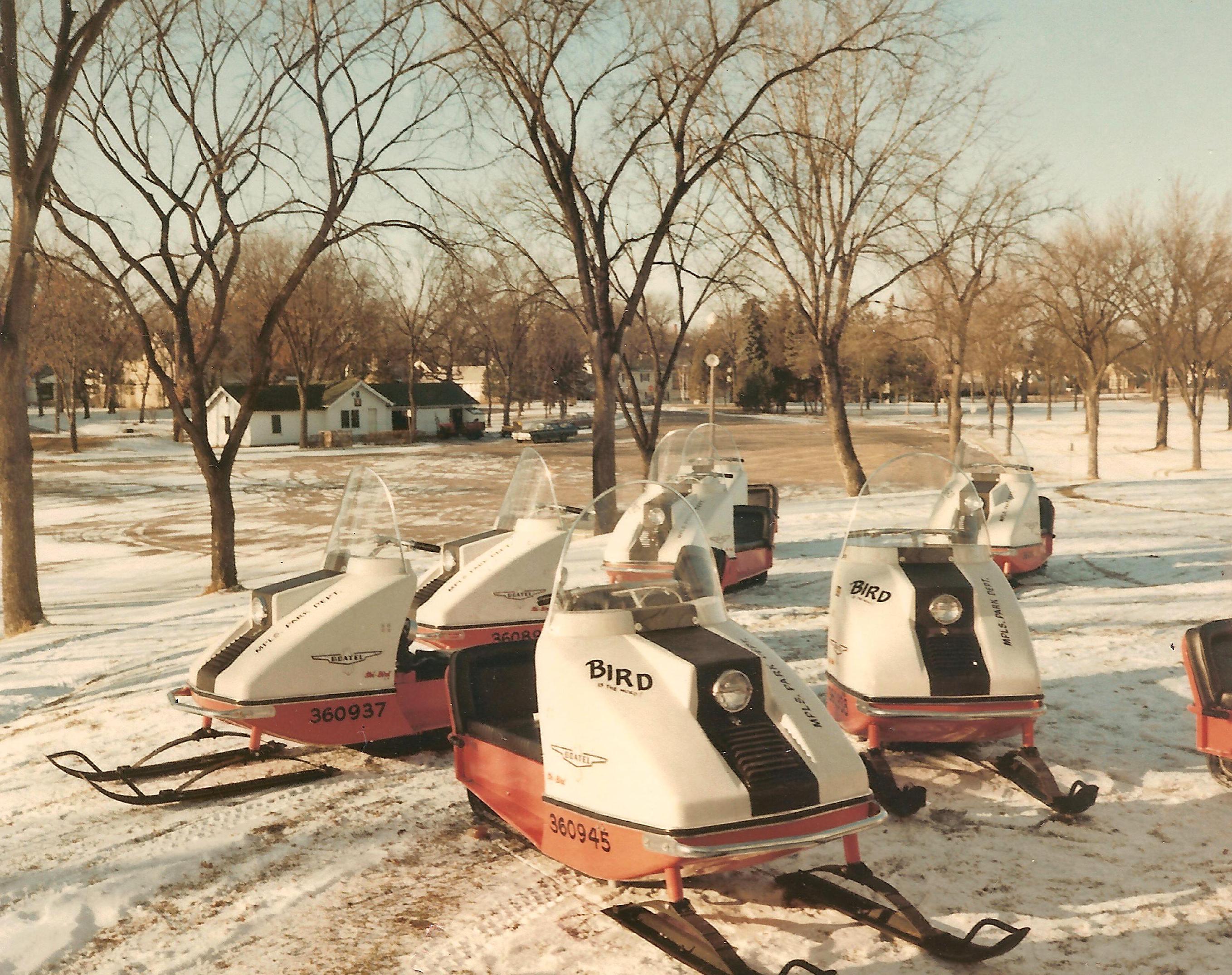
Snowmobiles for rent at Meadowbrook Golf Course in 1967. (MPRB)
I watched the Vikings Super Bowl IV loss as part of a football/snowmobile party on a farm near Hutchinson in January 1970. (Many farmers in the area were pioneers in snowmobiling, encouraged by the farm implement companies—and their local dealers—that initially invested in the technology. It gave the companies and dealers something to sell year round.) Maybe the Vikings’ embarrassing loss to the Kansas City Chiefs that day tainted my perception of snowmobiles, too; I developed a slight, queasy aversion to them, recalling Hank Stram’s infuriating smirk and bad toupee every time I saw one.
But the snowmobile photos on this page piqued my curiosity for a couple of reasons. One, I couldn’t remember the company “Boatel” or their “Ski-Bird” from my youth. Turns out it was a boat manufacturer in Mora, Minn. that acquired a snowmobile company, the Abe Matthews Company of Hibbing, to broaden its product line. The company apparently manufactured most of the machine, but installed an off-the-shelf engine.
For more information on the Boatel Ski-Birds visit snowmobilemuseum.com and vintage snowmobiles.
The second intriguing aspect of the photo above is the decal on the right front of the machine, “Bird is the word.” In the few photos I’ve found online of the machines — Boatel stopped manufacturing them by 1972 — none of the Ski-Birds have that tagline on them.
If you are of a certain age, or a huge fan of Minneapolis rock-and-roll history, or a Family Guy devotee, you know the line is most famous from a song by The Trashmen in 1963.
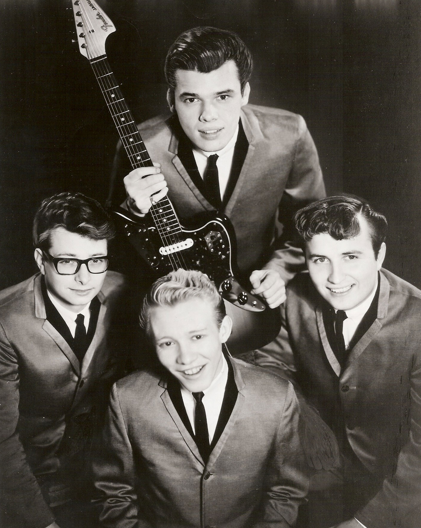
Cover photo of Minneapolis surf rockers The Trashmen from their Bird Dance Beat album, their follow-up to Surfin’ Bird. Steve Wahrer (front) was responsible for the raspy vocal on Surfin’ Bird.
The Minneapolis surf-rock band’s Surfin’ Bird, their first record, climbed to #4 on the Billboard Hot 100 and has been covered by numerous groups, from The Ramones to Pee Wee Herman. (See Wahrer performing the song on American Bandstand and being interviewed by Dick Clark. The show wouldn’t pay travel costs for all four band members, so Wahrer performed alone. It must have been odd for him to perform that way because he was the band’s drummer.) It’s a hard song to forget, which was reinforced by its use in a Family Guy episode in 2008 that introduced it to new generations.
I wonder if Boatel bought the rights to the lyric for its Ski-Bird. Surfin’ Bird was based on two songs by The Rivingtons and although The Trashmen significantly reworked them, The Rivingtons, a LA vocal group, were given songwriting credit. So if Boatel did pay rights to use the line, The Trashmen probably didn’t collect anything from it.
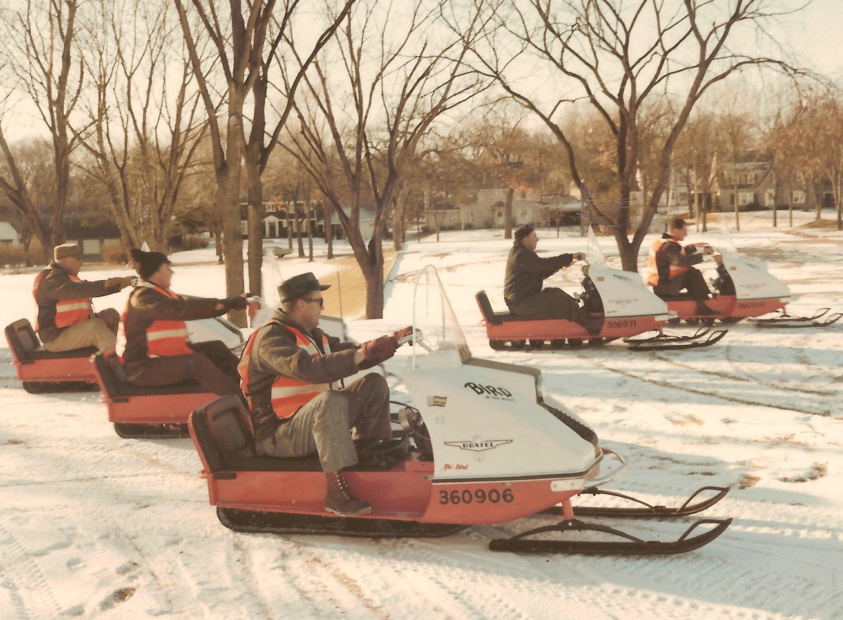
I don’t know if these are customers renting snowmobiles or park board employees at Meadowbrook Golf Course. (MPRB)
The park board’s 1968 annual report noted that “ski sleds” were rented at “various wintertime locations.” I was surprised to learn from the 1968 annual report that it was also the first year electric golf carts were used on any Minneapolis park golf course; they were also first rented at Meadowbrook. So snowmobiles beat golf carts onto park board golf courses by a few months. The contract for 13 snowmobiles and 6 snowmobile sleds for rental was won by the Elmer N. Olson Company.
Golf carts and snowmobiles weren’t the only attractions added to parks in 1968 in hopes of generating new revenue. Pedal boats were added to Loring Lake, an electric tow rope was installed in the Theodore Wirth Park ski area, and construction began on a miniature sternwheeler paddle boat to carry 35-40 passengers at a time on rides through Cedar Lake, Lake of the Isles, and Lake Calhoun.
A constant in the 129-year history of the Minneapolis park board has been the search for new revenues to support an expensive park system. If given a choice between snowmobiles in the city and good food at well-run restaurants in parks, such as now exist in three locations and will be joined by a new food service at Lake Nokomis next year, I’d chose the food. Blame the Kansas City Chiefs.
I haven’t found any record of rental rates for the snowmobiles the first year, but in January 1969 the park board approved a rental rate of $3.64 per 1/2 hour (plus 3% sales tax!) for park board snowmobiles and a charge of $1.25/hour or $3.75/day for the use of private snowmobiles on the Meadowbrook course.

I wonder if the Meadowbrook greenskeeper liked snowmobiles on the course with so little snow. (MPRB)
A more contentious issue was a park ordinance passed in early January 1968 that permitted, but regulated, the use of snowmobiles on Minneapolis lakes and parks. By November 1970, before a third snowmobiling season could begin, some residents had apparently had their fill of snowmobiles in the city and the park board considered banning the use of snowmobiles on park property, including the lakes. Park Commissioner Leonard Neiman, who represented southwest Minneapolis, proposed rescinding the ordinance that allowed snowmobiling, which suggests that residents near Lake Harriet and Lake Calhoun might have led the opposition. The board did not vote to eliminate snowmobiling from parks at that time, but it did reduce the speed limit for snowmobiles — from 25 to 20 mph — and added a noise-control provision that mandated mufflers. It also directed staff to consider which parks or lakes snowmobiles would be permitted to use. The decision to lower the speed limit on snowmobiles in parks was credited in 1979 (12/19 Proceedings) with essentially eliminating snowmobile permit applications. None had been received since 1972.
Sometime between 1979 and 2002 the park board made slow snowmobiling even less appealing by setting the price for an annual snowmobile permit at $350. Pokey and pricey wasn’t a big sale. The board voted in 2002 to eliminate snowmobiling permits altogether, because no one had applied for one in many years.
The park board proposes now to charge $1,000 a day for permitting snowmobiles (does that cover multiple machines?) to use Wirth Lake during a convention that MEET Minneapolis estimates will bring $1 million to the city this winter. Sounds like a reasonable trade-off to me — especially because snowmobiles have changed so much since 1970, and so few residences are within earshot of Wirth Lake anyway
Finally, here’s your cocktail party trivia for this week. One of only four survivors of the raft of companies that competed for snowmobile market share in the late 1960s is Bombardier, the Canadian makers of Ski-Doo. The company is now 50% owned by Bain Capital of presidential campaign fame. Of course, two of Ski-Doo’s biggest competitors are Arctic Cat and Polaris, both based in Minnesota.
I wonder if any of the Trashmen ever rented a “Bird is the word” snowmobile at Meadowbrook.
Papa-oom-mow-mow.
David C. Smith
© David C. Smith
1955 Was a Very Dry Year
Filed under: Minneapolis parks | Tags: Bassett's Creek, Brownie Lake, Fairchild Aerial Surveys, Lake Calhoun, Lake of the Isles, Minnehaha Creek, Mississippi River, St.Anthony Falls
Comments (9) It’s not a common sight. I’d never seen it myself until I saw this picture from Fairchild Aerial Surveys taken in 1955. St. Anthony Falls is completely dry.
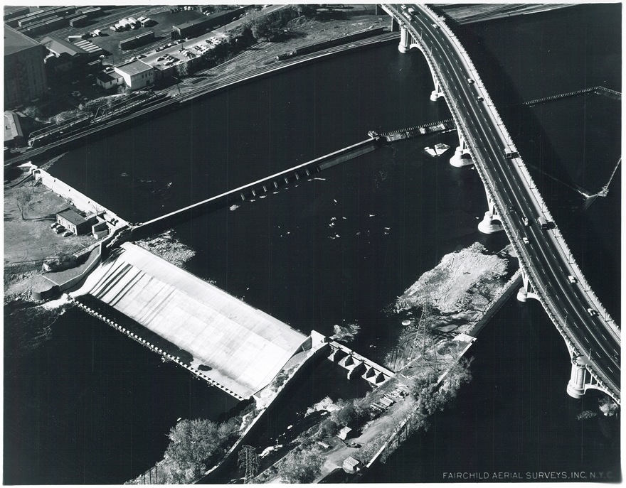
The concrete apron at St. Anthony Falls is bone dry in 1955. The 3rd Avenue Bridge crosses the photo. Dry land — even a small structure — left (west) of the falls stand where the entrance to the lock is now. (Fairchild Aerial Surveys, Minneapolis Park and Recreation Board)
Water levels were down everywhere at the time. Meteorological charts list 1955 as the 13th driest year on record in Minneapolis, but a look at longer-term data reveal that rainfall had been below normal for most of the previous 40 years. Downstream from St. Anthony Falls, the river was also very low, revealing the former structure of the locks at the Meeker Island Dam.

The old lock structure from the Meeker Island Dam protrudes from the low water in 1955. The old lock and dam between Franklin Avenue and Lake Street were destroyed when the new “high dam” or Ford dam was built near the mouth of Minnehaha Creek downriver. (Fairchild Aerial Surveys, Minneapolis Park and Recreation Board)
That dry spell had a significant impact on park property. Many park board facilities, from beach houses to boat houses and docks, were permanent structures that required proximity to the water’s edge. Parks were also landscaped and mowed to the water line and, since the depression, at least, many lakes had WPA-built shore walls that looked goofy a few feet up on dry land.
Park board annual reports provide time-lapse updates.
1948: Minnehaha Creek dry most of the year, lakes down 1.5 feet.
1949: Chain of Lakes 2 feet below normal, rainfall 2.5 inches below normal, water in Minnehaha for limited time during year
1950: Lake levels at record lows, lake channels dredged 4.5 feet deeper to allow continued use, water in Minnehaha Creek for only brief period in spring
1951: Record snowfall and heavy rains raised lake levels 0.44 feet above normal in April; flooding problems along Minnehaha Creek golf courses required dikes to make courses playable; attendance at Minnehaha Park high all year due to impressive water flow over falls.
1952: Wet early in year, dry late; lake levels stable except those that depend on groundwater runoff, such as Loring Pond and Powderhorn Lake, which were down considerably at end of year
1953: Lake levels fluctuated 1.5 feet from early summer to very dry fall; flow in Minnehaha Creek stopped in November; U.S. Geological Survey began testing water flow in Bassett’s Creek for possible diversion
1954: Again, water level fluctuations; near normal in early summer, low in fall; Minnehaha Creek again dry in November.
1955: Fall Chain of Lakes elevation lowest since 1932, but Lake Harriet near historical normal; Minnehaha dry most of year
1956: Lakes 4 feet below normal, weed control required, boat rentals incurred $10,000 loss
1957: City water — purchased at a discount! — pumped into lakes raised lake levels 1.5 feet; park board began construction of $210,000 pipeline from Bassett’s Creek, which, unlike Minnehaha Creek, had never been completely dry, to Brownie Lake.
1958: Second driest year on record; Minnehaha Creek dry second half of year; pumps activated on pipeline from Bassett’s Creek, raised water level in lakes 4.2 inches by pumping 84,000,000 gallons of water.
1959: Dry weather continued; Park board suggested reduction in water table may be result of development; Park board won a lawsuit against Minikahda Club for pumping water from Lake Calhoun to water golf course. When Minikahda donated lake shore to park board for West Calhoun Parkway in 1908 it retained water rights, but a judge ruled the club couldn’t exercise those rights unless lake level was at a certain height — higher than the lake was at that time — except in emergencies when it could water the greens only. Lakes were treated with sodium arsenite to prevent weed growth in shallower water; low water permitted park crews to clean exposed shorelines of debris.
1960: Lake levels up 4 feet due to pumping and rain fall; channels between lakes opened for first time in two years; hydrologist Adolph Meyer hired to devise a permanent solution to low water levels.

To celebrate the rise in water levels sufficient to make the channels between the lakes navigable after being closed for a couple of years, park superintendent Howard Moore helped launch a canoe in the channel between Lake of the Isles (in background) and Lake Calhoun in 1960. He seems not to mind that one foot is in the drink. (Minneapolis Park and Recreation Board)
That’s more than a decade’s worth of weather reports. The recommendation of hydrologist Adolph Meyer was very creative: collect and recycle water from the air-conditioners in downtown office buildings and stores, and pump it to the lakes. That seemed like a good idea until the people who ran all those air-conditioners downtown thought about it and realized they could recycle all that water themselves through their own air-conditioners and save a lot of money on water bills. End of good idea. Instead the park board extended its Chain of Lakes pumping pipeline from Bassett’s Creek all the way to the Mississippi River. But that’s a story for another time.
If you’ve followed the extensive shoreline construction at Lake of the Isles over the last many years, you know that water levels in city lakes remains an important, and costly, issue—and it probably always will be. It’s the price we pay for our city’s water-based beauty.
David C. Smith
Afterthought: The lowest I ever remember seeing the river was following the collapse of the I-35W bridge. The river was lowered above the Ford Dam to facilitate recovery of wreckage from that tragedy. Following a suggestion from Friends of the Mississippi River, my Dad and I took a few heavy-duty trash bags down to the river bank near the site of the Meeker Island Dam to pick up trash exposed by the lower water levels. Even then the water level wasn’t as low as in the Fairchild photos.