Archive for the ‘Minnehaha Falls’ Category
Minnehaha Rails
Filed under: Minneapolis Parks: General, Minnehaha Falls | Tags: Bureau of Mines: Twin Cities Research Center, Minnehaha Falls, Minnehaha Limestone Quarry, Mississippi National River and Recreation Area
 Comments (5)
 Rene Rosengren recently sent some photos of metal rails she found south of the Minnehaha Off Leash Dog Park just off the Minnehaha Trail. Any ideas what they are?
I’ve written about the limestone quarry at Minnehaha Park that was operated for just one year by the park board in 1907, but was reopened by the WPA from 1938-1942. I think these tracks are too far south to have been part of that quarry, but the narrow gauge suggests that they were part of a quarry or similar extraction enterprise.


I suspect the tracks were once a part of the Bureau of Mines Research Center on federal land that is now owned by the National Park Service as part of the Mississippi National River and Recreation Area.
Rene and I would be happy to hear any thoughts on the narrow gauge tracks.
David Carpentier Smith
Ironing Out Minnehaha Creek’s Wrinkles
Filed under: Minneapolis parks, Minnehaha Creek, Minnehaha Falls | Tags: Minnehaha Creek
Comments (4) A reader checked in a few weeks ago with a question: Did Minnehaha Creek ever cross West 54th Street in the southwest corner of Minneapolis?
I pulled out my 1903 Minneapolis Real Estate Atlas and was surprised to find that the creek did cross what is now West 54th St. for a few hundred feet. At that time, 54th St. was the southern city limit of Minneapolis.

The park board didn’t acquire this section of Minnehaha Creek — from Humboldt to Zenith — until 1930, and graded and straightened sections of the creek in 1932. The creek would have been straightened here as elsewhere to avoid the expense of building bridges. (Read more about the acquisition and development of this section of Minnehaha Creek. Go to the “History” tab at the bottom of the page.)
The section of Minnehaha Creek acquired in 1930 never had a parkway built along it as was done east of Humboldt. That was partly because some homes had already been built near the creek and also because the creek banks were much steeper here than to the east. But even if it had been perfectly flat and unoccupied, the Great Depression had set in so there was no money for new parkways.
According to Hennepin County property records the first house along this section of W. 54th St. was not built until 1942. That was a rarity because very few houses were built in Hennepin County during World War II due to a shortage of labor and materials. The rest of the houses along the street were built after the war, mostly from 1948 on.
What other changes were made to the course of Minnehaha Creek over the years? Here are three other sections of the creek from the 1903 atlas that you can compare to Google Maps to see what’s changed. Most of the changes were made in the 1920s partly to make it easier to improve the parkway to accommodate car traffic and partly to shorten the course of the creek to try to increase water flow over Minnehaha Falls in drought years — which was most years in the 1920s-1950s. No one seemed to like an empty creek and dry falls.

You can view many other early maps of Minneapolis — and spend hours and hours of COVID-avoidance free time — at the University of Minnesota’s John Borchert Map Library website. Countless maps — and aerial photography as well. You’ll be happier and smarter. Stay healthy.
David Carpentier Smith
Accept When Offered: A Brief History of Minnehaha Parkway
Filed under: Minneapolis parks, Minnehaha Creek, Minnehaha Falls | Tags: Charles M. Loring, Horace Cleveland, Minnehaha Creek, Minnehaha Parkway history, Theodore Wirth
Comments (2) Given recent discussion of the history of Minnehaha Parkway, I thought it might be useful to consider a brief timeline of when and why the parkway was acquired by the Minneapolis Board of Park Commissioners and how it was developed. I wrote some of this for the Minneapolis Park and Recreation Board in 2008, but it is not presently accessible at minneapolisparks.org. Most other individual park histories, such as Minnehaha Park and Minnehaha Creek Park (the creek west of Minnehaha Parkway to Edina), are available there under the “History” tab on each park page. I would encourage you to read them.
Park board records do not reveal the origin of the idea of a parkway along the valley of Minnehaha Creek. The first mention of a park along the creek is in the park board proceedings of October 8, 1887 when, after hearing from “interested parties,” the park board resolved that when lands along Minnehaha Creek “are offered, they be accepted” between Lake Harriet and the Soldier’s Home. (The Soldier’s Home was then planned to be built at the mouth of Minnehaha Creek on the Mississippi River on land donated to the state by the city. Minnehaha Falls was not yet a park, although it was in the works.) As part of the resolution, the park commissioners expressed their intent to create a parkway beside the creek when they deemed best to do so—meaning if they ever had the money.

An early 1900s postcard image of the parkway and path at an unknown location. Don’t you want to follow that path? It’s a favorite image I included in City of Parks: The Story of Minneapolis Parks
Today Minnehaha Parkway begins at Lake Harriet Parkway on the south shore of Lake Harriet and Continue reading
Hiawatha and Minnehaha Do Chicago
Filed under: Minneapolis parks, Minnehaha Falls | Tags: Daniel Chester French, Hiawatha and Minnehaha Statue, Jakob Fjelde, Minnehaha Falls, Ole Bull Statue, William Watts Folwell
Leave a comment The World’s Columbian Exposition in Chicago hosted the debut of Minneapolis’s most famous sculptural couple, Hiawatha and Minnehaha, in 1893.
The Minnesota building at the World’s Columbian Exposition in 1893 featured Jakob Fjelde’s sculpture of Hiawatha and Minnehaha in the vestibule.
Zoooom.
Hiawatha and Minnehaha greeted visitors to the state’s pavilion in their modest plaster costumes nearly two decades before sculptor Jakob Fjelde’s pair took their much-photographed places on the small island above Minnehaha Falls in their bronze finery in 1912.

Hiawatha and Minnehaha in their customary place above Minnehaha Falls. This photo, from a postcard, was probably taken in the 1910s. I chose this picture not only because Hiawatha appears to be climbing a mountain of rocks to cross the stream, unlike today, but also because it is a Lee Bros. photo, the same photographers who shot the photo of Fjelde below.

Jakob Fjelde, Lee Bros., year unknown. I like the cigar. (Photo courtesy of cabinetcardgallery.wordpress.com)
Jakob Fjelde was largely responsible for two other sculptures in Minneapolis parks. He created the statue of Ole Bull, the Norwegian violinist, in Loring Park in 1895. He also created the drawing that Johannes Gelert used after Fjelde’s death to sculpt the figure of pioneer John Stevens, which now stands in Minnehaha Park. Fjelde also created the bust of Henrik Ibsen, Norway’s most famous writer, that adorns Como Park in St. Paul. Fjelde’s best-known work other than Longfellow’s lovers, however, is the charging foot soldier of the 1st Minnesota rushing to his likely death on the battlefield of Gettysburg.

Fjelde’s simple commemoration of the sacrifice of Minnesota men at a pivotal moment in the Civil War. The sculpture was installed in 1893 and dedicated in 1897. (Photo: Wikipedia)
These thoughts and images of sculpture in Minneapolis parks were prompted in part by my recent post on Daniel Chester French, but also by another letter found in the papers of William Watts Folwell at the Minnesota Historical Society. Just two years after Fjelde’s successes with his sculptures for Gettysburg and Chicago, he wrote a poignant letter to Folwell in July 1895 seeking his support for an “extravagant” offer. Fjelde proposes to the Court House Commission, which was developing plans for a new City Hall and Court House, that he create a seven-foot tall statue of the Chief Justice of the U.S. Supreme Court, John Marshall, and a bronze bust of District Court Judge William Lochren, both for the sum of $1,400. Fjelde calls the price of $1,000 for the Marshall statue “1/3 of its real value.” He explains his offer to Folwell:
“Anyone who knows a little about sculpture work will know that the sums above stated are no price for such a statue but as I for the last six months have been unable to get any work to do at all and have wife and four children to take care of and in spite of utmost economy, unable to make both ends meet, I am obliged to do something extravagant, if only I can get the work to do.”
Fjelde adds that $400 for a bronze bust of Lochren would only pay for the bronze work, meaning that he would be creating the bust free. He writes that he is willing to do so because by getting Lochren’s bust into the Court House, “it might go easier in the future to get the busts of other judges who could afford to give theirs, so I would hope that would give me some work later on.”
He concludes his plea by noting that with his proposition, “The Court House would thereby get a grand courtroom hardly equalled in the U.S.”
Although I have not searched the records diligently, I have not come across anything to suggest that the Court House Commission accepted Fjelde’s offer. That may be because barely two weeks after writing his letter, the Norwegian Singing Society, led by Fjelde’s friend, John Arctander, began to raise money for a statue of Ole Bull. Fjelde began work on that statue in 1895. When all but the finishing touches were completed on the image of the Norwegian maestro the next spring, Fjelde died. He was 37.
I can’t leave another sculpture story without returning a moment to Daniel Chester French. In a longer piece on French a couple of weeks ago, I noted that when his Longfellow Memorial at Minnehaha Falls didn’t materialize, he moved on to create an enormous sculpture for the Chicago World’s Fair. Here it is in its massive splendor. It stood 60 feet tall,

Daniel Chester French’s Republic looms over the Columbian Exposition.
French’s Chicago sculpture was much larger than Fjelde’s, but Fjelde’s sculpture eventually found a home at Minnehaha Falls, where French’s proposed sculpture of Longfellow did not.
David C. Smith
© 2015 David C. Smith
Minnehaha Falls 1912: A Feather in the Cap
Filed under: Minneapolis parks, Minnehaha Falls | Tags: Minnehaha Falls
Comments (3) Minnehaha Falls has been called the most-photographed site in Minnesota. Based on my study of photos and postcards over the last several years, I would agree. Still there’s often something a little different in the next photo I see — if not in the falls themselves, in something else that’s frozen in the moment the shutter opens.
Take this superb photo recently sent to me by Robert Henry. It was taken by his grand uncle Frank Prochaska, an amateur photographer, in 1912.

Minnehaha Falls, 1912 (Photographer: Frank Prochaska. Courtesy of Robert Henry.)
I like the photo because it shows someone on the bridge above the falls, the viewing platform to the left of the falls, which hasn’t existed for decades, a man and child near the cascade, and the wider flow of water over the lip of the falls. So much going on. But most of all I love the hats of the people on the stone-faced pedestrian bridge below the falls — and their postures. An instant of Minneapolis park history as six people witnessed it and Frank Prochaska captured it 103 years ago.
Thanks, Robert.
David C. Smith
Last Minute Reminders: Minnehaha Falls and the Minneapolis Institute of Arts
Filed under: Minneapolis parks, Minnehaha Falls | Tags: Karen Cooper, Linden Hills History Study Group, Minneapolis Institute of Arts, Minnehaha Falls
Comments (2) In case you forgot.
Karen Cooper is speaking tonight at 7 at St. John’s Episcopal Church on Sheridan Ave. South and 42nd on Minnehaha Falls. Still plenty of time to grab a bite to eat and get to Linden Hills. Should be informative. Karen has promised some new revelations about the history of Minneapolis’s most famous park and she has a library of great photographs of the park and falls.
I will be speaking Saturday morning at 11 at the Minneapolis Institute of Arts. The title of my presentation is Arts and Parks: Culture and Beauty on the Frontier. I’ll talk about the indefatigable promoters of both fine arts and parks in the early history of Minneapolis.
Hope to see you at one or both.
David C. Smith
Minneapolis Park History Update
Filed under: Minneapolis parks, Minnehaha Falls, Mississippi River | Tags: Minnehaha Falls, Mississippi River Gorge, St. Peder's Danish Evangelical Lutheran Church
Leave a comment I enjoyed seeing many of you last Monday night at St. Peder’s Church for the Longfellow Community presentation on the Mississippi River Gorge. I promised Carolyn Carr that I would provide a brief synopsis of my presentation and post a few of the photos here. And I will. But first I wanted to post a photo I forgot to include in my presentation.
As a tribute to our hosts on Monday night, I wanted you to see this wonderful photo from the Hennepin County Library special collection. I haven’t given a proper plug to the library or the historical society in a while. They remain marvelous resources. If you haven’t visited Special Collections at the Central Library or the library at the Minnesota History Center in St. Paul, you really should. Take some time for the exhibits at the history center too. And for those of you who prefer to shop locally, you can buy your copy of City of Parks in their book store instead of online! Can’t beat that.

The congregation of St. Peder’s Danish Evangelical Lutheran Church at Minnehaha Falls in 1886 — before the falls became a park. Some parishioners must have had large families of daughters. (Hennepin County Library, Special Collections)
Thanks to the descendants of those in the picture, physically or spiritually, for providing the venue for last Monday’s meeting.
Speaking of special collections at the Central Library, it looks as if I may reprise—and embellish—my presentation on the Mississippi River Gorge at the Library on October 3. I hope to travel this summer to libraries in other parts of the country to continue my research into the life and work of H.W.S. Cleveland, so I may have some new nuggets for that presentation. I’ll keep you posted.
David C. Smith
Frozen Falls: Minnehaha in Winter
Filed under: Minneapolis parks, Minnehaha Falls | Tags: Charles Zimmerman, Minnehaha Falls
Comments (8) A frozen Minnehaha Falls has always intrigued people. Many photos exist of the falls in winter, including those published recently in the StarTribune that created a ruckus. Several shots of the ice wall were popular as postcards in the early 1900s, such as the one below.
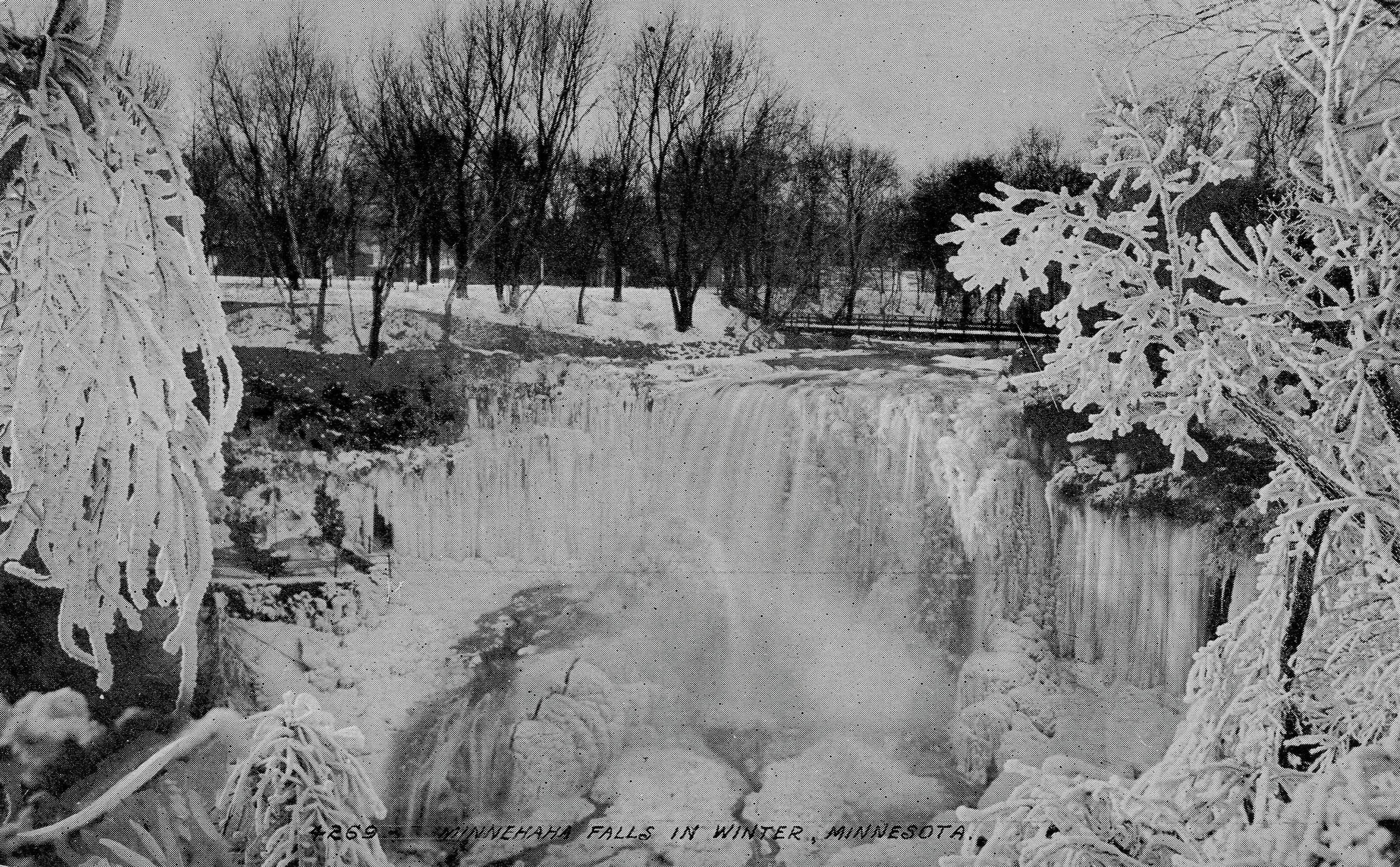
Minnehaha Falls on a postcard around 1910.
I recently received a photo from Edward Tobin Thompson of Maple Grove that I like as well as any.

Minnehaha Falls in January, 1899. (Photo courtesy Edward Tobin Thompson)
The photo, dated January 15, 1899, comes from an old family photo album. Ed doesn’t know who is standing at the foot of the falls, but it is likely the same man pictured on the park bench below, a photo that carries the same date and inscription on the back.

Resting on a bench in Minnehaha Park, January 1899. Judging from the hat, this may be the same man posing in front of the falls. (Photo courtesy Edward Tobin Thompson)
Ed guesses that the man is one of his Tobin ancestors. The Tobins immigrated from Ireland and settled in Wisconsin about 1846, he says. They later lived in the Upper Peninsula of Michigan before moving to Montana.

An imitation Minnehaha Falls? Date and place unknown. (Courtesy Edward Tobin Thompson)
Ed also sent this photo of a waterfall without a label from the same album and he wondered if it could be Minnehaha Falls as well. I don’t think so because in hundreds of pictures I’ve never seen the lip of the falls or the pattern of falling water like this, or the pool of water below the falls so large. Any opinions? Are you watching, Karen Cooper? (Karen has to be the world’s leading authority on images of Minnehaha Falls.) If not Minnehaha Falls, what falls? Any other cataracts in Wisconsin or Minnesota like this? Send in your guesses.
Danger Under the Falls
When photos appeared in the StarTribune recently of people behind the frozen falls, it brought to mind a story from Frank Leslie’s Illustrated Newspaper dated December 25, 1869, which was featured in Minnesota History, the magazine of the Minnesota Historical Society.

An engraving of photographer Charles Zimmerman being knocked unconscious by an icicle, November 28, 1869.
The article described a near tragedy when the falls wasn’t completely frozen. The article was illustrated by the engraving at right. This is how the events involving well-known photographer Charles Zimmerman were originally described in the newspaper:
“Wishing to obtain winter views of a place Longfellow has immortalized in his classic verse, Mr. Zimmerman passed under the falls. An hour later, a Mr. Haines, while exploring the rocks, happened to look behind the curtain of water as it leaped from the edge of the precipice to the abyss beneath and was startled by what he saw. A large icicle weighing between two and three hundred pounds, loosened by the thaw, had severed its connection with the roof above, and had fallen on Mr. Zimmerman, crushing him down, and leaving him insensible beneath it. Mr. Haines quickly relieved the prostrate artist, whom he found nearly frozen. Indeed, had succor been delayed half an hour longer, the unfortunate man would have most certainly died.”
The photographer conked on the head by the giant icicle, Charles Zimmerman, became one of the most prolific shooters of scenes in St. Paul and Minneapolis in the late 1800s. Most of his photographs were sold as stereoviews, the side-by-side photos that took on a 3D appearance when viewed through a stereoscope. If Zimmerman had perished that day under the ice of Minnehaha Falls we would not have nearly so thorough or enjoyable a record of life in Minneapolis in the 19th Century.
Don’t Be Left Insensible
I’d recommend that you not climb up under the falls either. (It is illegal!) Maybe you will do something memorable someday, as Charles Zimmerman did, if you live a little longer.
David C. Smith
© 2015 David C. Smith
Mississippi River flood
Filed under: Minneapolis parks, Minnehaha Creek, Minnehaha Falls, Mississippi River | Tags: Ford Dam, Minnehaha Falls, Mississippi River
Leave a comment Saturday afternoon I spent a bit more time looking at high water around the city. On that gorgeous afternoon, Minneapolis parks were heavily patronized, partly because of the beautiful day and partly because people were curious about the effects of our summer deluge.
The banks of the Mississippi River that I helped clean in April were under water again. Maybe when these flood waters subside, Friends of the Mississippi River should sponsor another trash pick up. Or we could each take a trash bag along when we go out for riverside hikes.
More evidence of high water on the big creek at the Ford Dam.

High water over the Ford Dam, June 21, 2014. Late last summer, there was no water flowing over the dam and below the dam was mostly dry land. (David C. Smith)

Last summer you could walk from the locks to the island where the submerged trees are now. The Ford Dam is just to the left of this photo. (David C. Smith, June 21, 2014)
Both photos were taken from the bluff at Minnehaha Park and the Soldiers Home. Water levels in Minnehaha Creek had subsided little, if at all, from Thursday to Saturday. Water was still thundering over Minnehaha Falls.
David C. Smith
Minnehaha Falls and Creek: Flood Stage
Filed under: Minneapolis Lakes, Minneapolis parks, Minnehaha Creek, Minnehaha Falls | Tags: Hiawatha Golf Course, Minnehaha Creek, Minnehaha Falls, Minnehaha Parkway
Comments (8) As we await another early evening thunderstorm, I will post a few historic photos of Minnehaha Creek and Minnehaha Falls taken earlier this afternoon. I call them historic because I’ve never seen the creek this high. One man I encountered on my explorations claimed it was a record water level for the creek. I’ll have to look that up.
The entire length of the creek was flooded, of course, even a few hours after the rain had stopped, but these three photos establish landmarks.

The bridge to nowhere. The creek normally flows under the bridge near the top of the photo. Minnehaha Parkway at Humboldt Avenue South, south of the Lynnhurst Recreation Center. (David C. Smith)
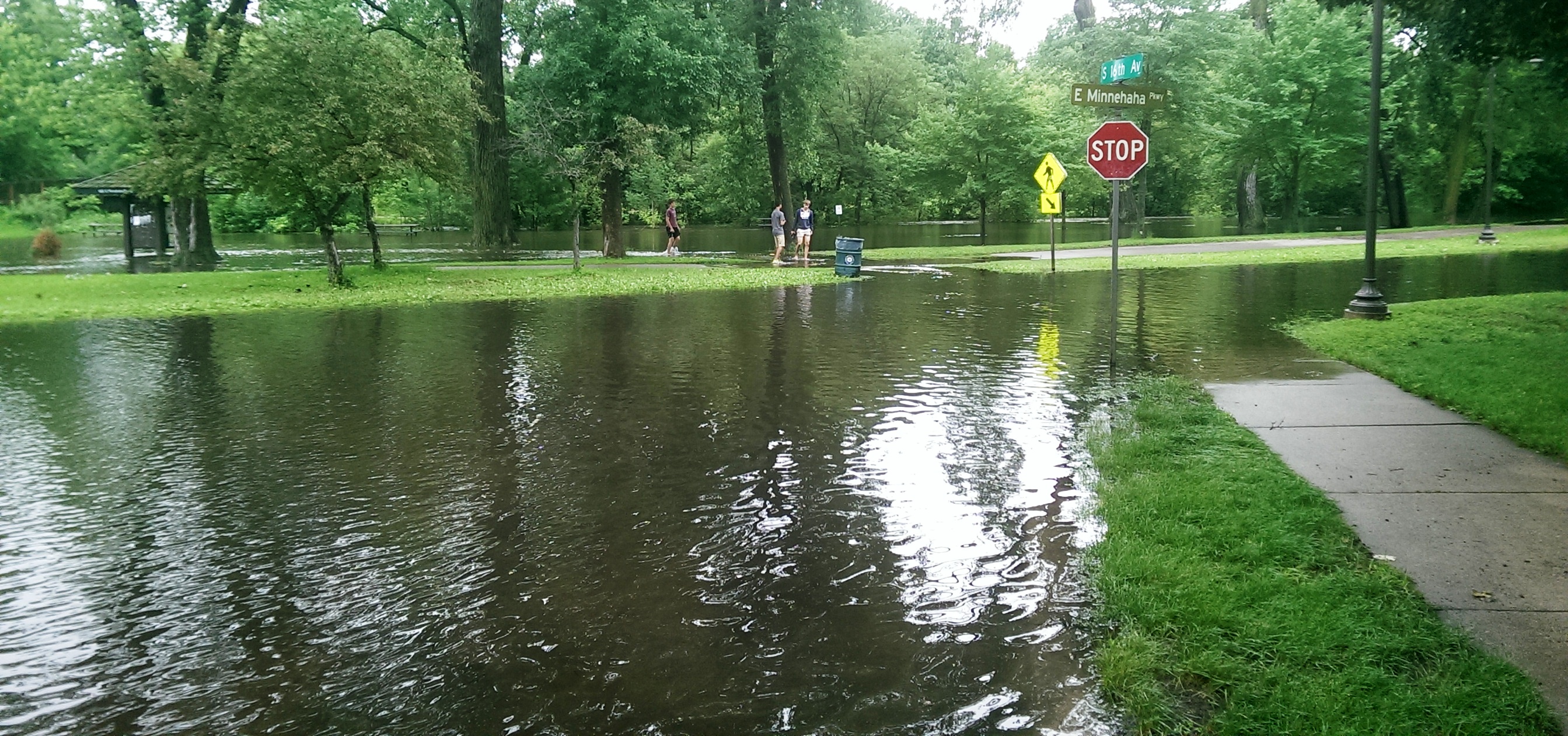
Minnehaha Parkway at 16th Avenue South. (David C. Smith)

Looking west on Minnehaha Parkway at Cedar Avenue South. (David C. Smith)
A man I met near Cedar Avenue claimed that the water reached a similar level after a 1988 thunderstorm, but the water subsided very quickly. Today it didn’t. Minnehaha Parkway was barricaded at many points east of Lake Harriet.

More than a water hazard. Hiawatha Golf Course looking south from E. 43rd Street near Standish. That is not Lake Hiawatha in the foreground. (David C. Smith)

A romantic interlude at the famous rapids of Minnehaha Creek! This is only a few yards upstream from the Hiawatha statue. (David C. Smith)
Some early descriptions of the Falls mentioned the heavy mist generated by the falls. That was true today. There was no rain falling while I was taking the pictures below, but I could feel the water in the air. Not quite as dramatic as Victoria Falls, where the cloud of mist over the falls is visible for miles — it’s called Mosi-o-Tunya, the Smoke that Thunders — but still impressive for this normally modest stream in mid-summer.
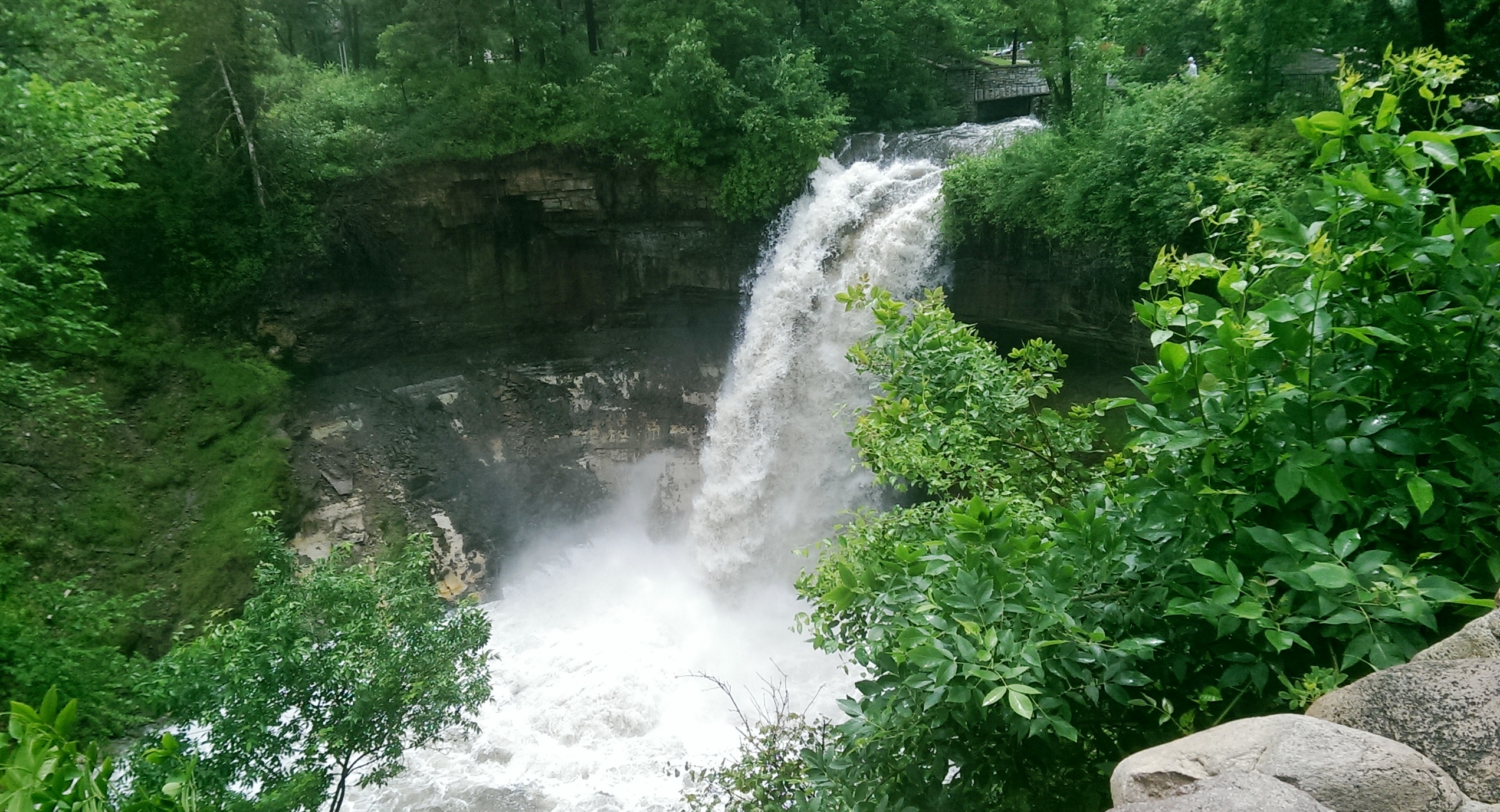
The falls made famous by Henry Wadsworth Longfellow. I recently discovered startling early plans for the park at the falls that I am waiting for permission to reveal. Stay tuned. (David C. Smith)
Unfortunately such high water levels, like the strong winds of recent years, require expensive cleanup efforts from the park board, stretching already tight park maintenance budgets. Kudos and thanks to the park board crews that will put our water-logged parks in beautiful condition yet again.
David C. Smith
© David C. Smith
Does anyone have any pictures to post of Bassett’s Creek in Theodore Wirth Park or downstream to Bryn Mawr before it dives underground? Is Shingle Creek any better?
Minnehaha Park Fireplace Mystery Solved
Filed under: Minneapolis parks, Minnehaha Falls | Tags: Folwell Park, Keewaydin Park, Marv Nelson, McRae Park, Minneapolis Veterans Hospital, Minnehaha Dog Park, Minnehaha Park
Comments (3) The mystery of the fireplace in the dog park at Minnehaha Park has been solved thanks to reader “Tom.” Many people have followed this issue or expressed an interest in it and I know that many readers don’t check back to see comments on posts, so I wanted to bring this comment to your attention.

The fireplace surrounded by picnic tables in 1935. (Minnesota Historical Society)
This is the photo of the fireplace that Tom found in the collection of the Minnesota Historical Society, which includes more than 230,000 photographs. As I’ve noted many times, that collection is invaluable and immensely enjoyable. The picnic ground belonged to the Minneapolis Veterans Hospital according to the photo description. Tom further notes that the park board acquired this land in 1959. Thanks for your comment, Tom. Does anyone want to tell us when the fireplace and picnic ground were built?
Excellent Comments
I would suggest that you check back on your favorite park subjects occasionally to see recent comments, or subscribe to comments on any post. Especially interesting in recent months have been
Chuck Solomon’s comment in which he named all of the coaches and nearly every player from a McRae Park football photo
Another tribute to Marv Nelson, a youth football coach at Folwell Park in the 1960s and 1970s
Memories of Keewaydin Park, especially kids’ games and hockey.
These are just a few of the comments in recent months. Thanks to everyone who has commented on the articles here or has contacted me personally with more stories. I appreciate them all. Stories: that’s what this web site is all about.
David C. Smith
© 2014 David C. Smith
Minnehaha Falls Photos
Filed under: Minneapolis parks, Minnehaha Falls | Tags: Minnehaha Falls, Minnehaha Park
Comments (2) Karen Cooper tells me she has photos of more 19th- and early 20th-Century bridges over Minnehaha Creek at Minnehaha Falls than the ones I’ve already posted. You can see those photos and more next Sunday, Feb. 10, at 2 pm at Hennepin History Museum. (Get more info here.)
I’m told that Karen has the most amazing Minnehaha Falls collection. I’m looking forward to seeing part of it myself for the first time. Hope to see you there.

The 1910 stone arch bridge was actually made of reinforced concrete and given a facade of boulders found in the vicinity. (Minnesota Historical Society)
David C. Smith

