More Edith Cavell School and Park
Filed under: Minneapolis Park Memory, Minneapolis parks | Tags: Cavell Park, Edith Cavell School
 Comments (3)
 Virginia (Dregger) Dantona sent a note a few weeks ago about my post on Edith Cavell Park and School. She included two photos and a recollection of the school and playground that I thought other readers would appreciate.
Virginia wrote: “I could not resist sending you two pictures of my classmates who enjoyed the playground before it became a park. The one taken on the steps of the school dates to 1944 or 1945, the other, by the side of the school, a few years earlier.”
![An informal class photo at Edith Cavell School from 1944 or 1945. (Photo courtesy of Virginia [Dregger]Dantona)](https://minneapolisparkhistory.com/wp-content/uploads/2014/11/cavell.jpg)
Edith Cavell School classmates in 1944 or 1945. (Virginia [Dregger] Dantona)
![Edith Cavell class in early 1940s. (Virginia [Dregger] Dantona)](https://minneapolisparkhistory.com/wp-content/uploads/2014/11/cavell-early-40s.jpg)
Some of the same kids a few years earlier. (Virginia [Dregger] Dantona)
Hardly a man is still alive, who remembers this catch in ‘45.
Bad weather meant indoor recess, held in Edith Cavell’s long hallway. We were playing volleyball, and the ball struck the ceiling fixture! As it fell, the fixture turned over, so the light bulb was on top, with its open glass shade beneath. It fell safely into my waiting hands, and became a vivid memory.
Thanks for the memory, Virginia. Other readers have commented on the original post, so you might check there to see more recollections of former Cavell students.
If you have memories of your favorite park or playground—or school playground that became a park—send me a note.
David C. Smith
Two New Park-Related Books by Joe Bissen and Sue Leaf
Filed under: Minneapolis Parks: General | Tags: Bryn Mawr, Camden Park, James Ford Bell Museum of Natural History, Joe Bissen, Lake Harriet, Lyndale Park, Minneapolis golf, Sue Leaf, Thomas Sadler Roberts
Comments (1) I’m happy to recommend two books that I’ve recently added to my shelves on Minneapolis history.
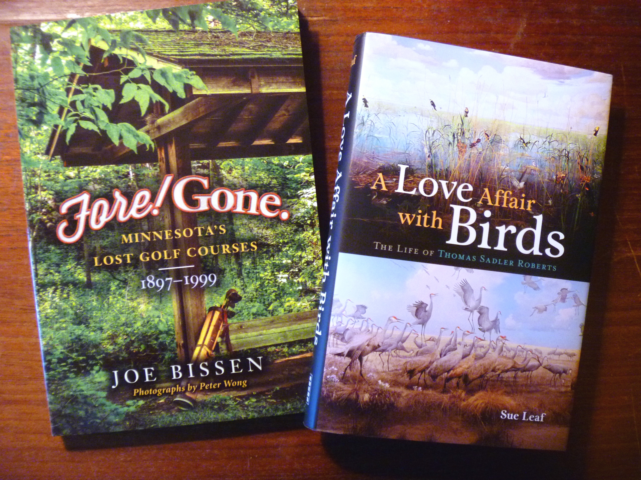
Two recent additions to my Minnesota history book shelves.
Fore! Gone. Minnesota’s Lost Golf Courses 1897-1999 by Joe Bissen. Joe contacted me after reading my pieces on the old Bryn Mawr Golf Club before it spun off Minikahda and then Interlachen. We ended up spending an enjoyable morning roaming around the Bryn Mawr neighborhood trying to pin down the location of the course and the clubhouse. It was a task made more difficult by the changes in street names and house numbering systems over the last 115 years. Bryn Mawr is only one of many long-gone golf courses that Bissen writes about in this entertaining book. If you’ve played much golf in the state, you’ll find these stories especially enjoyable, but you needn’t be a fan of “a good walk spoiled” to enjoy these stories of changing landscapes.
For Minneapolis history buffs, I’d recommend a visit to Joe’s blog as well, where he goes into greater detail on his search for more info on the ancient Camden Park Golf Club that was supposedly built around Shingle Creek by employees of C.A. Smith’s lumber company.
A Love Affair with Birds: The Life of Thomas Sadler Roberts, by Sue Leaf. The wild landscape north of Lake Harriet, which is named for Thomas Sadler Roberts, is widely known as a bird sanctuary in the Minneapolis park system. What is probably less-well known, is that the entire Minneapolis park system is a bird refuge — and has been for about 75 years. Roberts was a doctor and later in life an ornithologist at the University of Minnesota who was instrumental in creating the fabulous displays at the Bell Museum of Natural History at the U.
When I was still in grade school in the 1960s I remember my parents taking us to see those displays on Sunday afternoons. I don’t think they are as heavily visited now as they once were, but I had such fond memories of those life-like exhibits that I took my daughter there several times in this century. A couple of years ago I included in this blog a photo of wolves attacking a moose outside the museum.
Now, thanks to author Sue Leaf, I know the story of how the Bell Museum came into existence — as well as many other details of the life of a remarkable man. Leaf places Roberts’ life in the context of the early history of Minneapolis. His friends, colleagues and benefactors included many influential people in the creation of the city’s economy and institutions.
The story Leaf tells heightens appreciation for the wildlife habitat that Minneapolis parks have preserved not only in the Thomas Sadler Roberts Bird Sanctuary, but throughout the park system.
I hope you will keep both books in mind for your book-inclined friends and family this gift-giving season. Or buy one for yourself and save it for a day when you’re snowed in. Sorry, but you know it’s coming.
David C. Smith
Post script: Check back in a couple days and perhaps you can help us solve a mystery in Thomas Sadler Roberts Bird Sanctuary.
© 2014 David C. Smith
Minneapolis Speed Skating Update
Filed under: Minneapolis parks, Winter Sports | Tags: 1952 Winter Olympics, Powderhorn Park, Speed Skating
Comments (1) The articles I’ve posted on speed skating have been among the most widely read of all topics I have covered. Many readers also have added comments that are full of interesting information and reminiscences. So I would encourage anyone interested in the history of speed skating in Minnesota, especially at Powderhorn Park, to revisit those posts to catch up on the latest info. (Click on “Speed Skating” under “Popular Tags” at right for a list of articles.)
Along those lines, I got a recent note from Patrick Fitzgerald that the description of the photo of the 1948 Olympic team was correct even though it was taken in February, 1947. The 1948 team was selected based on results of the National Championships the year before.
Bob Fitzgerald was the first man named to the 1948 team as a result of his winning the Senior Men’s National Championship in January, 1947, a repeat of his 1946 title. Both times he edged out Ken Bartholomew, another Minneapolitan, for the title.

Who is this Bearcat skater?
A reader sent me a copy of the 11 x 14 photo above of an unknown skater, which he had found at a local garage sale. He purchased the photo as well as the size 10 Riedell skates the man in the photo was wearing. We believe he is wearing the uniform of the Bearcats from around 1950. Can anyone identify the skater?
I hope to have more recollections of the Powderhorn skating scene from the 1940s sometime this fall.
David C. Smith
© 2014 David C. Smith
“The Yard” — or Downtown East Commons: A Caution from Minneapolis Park History
Filed under: Minneapolis Park Names, Minneapolis Parks: General | Tags: Downtown East Commons, Pioneer Square, Shingle Creek, The Gateway, The Yard, Vikings Commons, Vikings Stadium, Wold Chamberlain Field
Comments (20) Hurrying to create a park in “The Yard” (since renamed the “Commons”) between downtown and the new Vikings stadium could result in disaster, if the history of Minneapolis parks provides any lessons. The greatest land-use mistakes in Minneapolis park history came from creating parks for purposes other than the relaxation, recreation, entertainment or edification of its citizens. Creating grounds for a pleasant stroll to a stadium eight days a year isn’t reason enough to make “The Yard” work as a park. Planning for those two blocks has to go well beyond landscaping only for the benefit of surrounding property owners, too.
An Expensive Failure: The Gateway
On four notable occasions, the park board has created parks largely for other than “park” reasons. The first, and still most-disastrous, was the creation of The Gateway in 1913 at the junction of Hennepin and Nicollet Avenues just west of old Bridge Square approaching the Hennepin Avenue Bridge. The triangular park was created to be an attractive “gateway” from the railroad station into downtown. The welcome intended for visitors, or travellers returning home, was clear from the words carved in stone on the pavilion at The Gateway:
“More than her arms, the city opens its heart to you.”
That slogan must have sounded less smarmy to 1913 ears than it does to mine. Parks, as well as slogans perhaps, were still on experimental footing in the “new” cities of the American west and The Gateway was the first venture of the Minneapolis Board of Park Commissioners into downtown Minneapolis.
The buildings razed to make room for the park reportedly housed 27 saloons, which for many park advocates was reason enough to create the park. But neither open heart nor closed saloons were enough to make the park successful.
The Gateway 1918 at the intersection of Nicollet Avenue (left) and Hennepin Avenue (right). The Mississippi River and Hennepin Avenue Bridge are behind the photographer, Charles P. Gibson. (Minnesota Historical Society)
By 1923, the park board was spending more than 5% of its annual citywide operating budget on the park, mostly on park police patrols, because, in addition to the city’s arms, the park board had opened toilets – er, “comfort stations” – in The Gateway’s pavilion. The park quickly became a favorite hangout for lumbermen between jobs, as well as the unemployed, indigent or inebriated. What was supposed to get rid of ugliness and beautify the city, became an eyesore itself.

This infamous 1937 photo may overstate the case, but it does suggest one typical use of the park. Notice however that there are no nappers across the street, on the block that holds the pavilion and fountain. (Minneapolis Star Journal, Minnesota Historical Society)
Despite an attractive pavilion and a fountain donated by Edmund Phelps (now in Lyndale Park near the Rose Garden), the park served too few constituents (or at least some the city thought undesirable) and little park purpose beyond decoration. The park was controversial even when it was built, with such thoughtful park observers as former park commissioners William Folwell and Charles Loring opposing the park. Loring’s wife owned some property condemned for the park, but nonetheless he predicted correctly that it would become a home for indigent men. (See Florence Barton Loring’s reflective response here.) The pavilion was closed and leveled in 1953 and the fountain was removed to Lyndale Park in 1963, when the old Gateway ceased to exist. (For the rest of The Gateway story go here, then click on “Parks, Lakes, Trails…”, then “Gateway” in the index.)

Fenced. Desolate. Doomed. The Gateway in July 1954 after demolition of the pavilion, looking toward the river from Washington Avenue. (Minneapolis Star Journal Tribune, Minnesota Historical Society)
The Gateway was by far the most expensive park built during the first thirty years of the Minneapolis park board’s existence. The total cost was nearly one million dollars, more than had been paid to acquire Lake Harriet, Lake Calhoun and Lake of the Isles – plus parks and parkways along both sides of the Mississippi River – combined!
A Huge Success: Wold-Chamberlain Field
The next time the park board was asked to build something for the city turned out quite differently. When Minneapolis needed an airport, the park board was the only municipal entity that could legally own land outside city limits. Therefore, it fell to the park board in 1928 to own and operate the municipal airport on the site of the old motor speedway next to the Fort Snelling military reservation. The park board operated and developed Wold-Chamberlain Field, built it into a respectable airport, and turned it over in the mid-1940s to the newly created Metropolitan Airport Commission. Chalk one up to collaboration among city, park, civic and business interests. The goals, however, were clear, unambiguous and limited – and in the 1920s the airplane was still little more than a curiosity. Few people anticipated the future importance of flying machines and places to land them.

Wold-Chamberlain Field, Minneapolis’s airport, 1941. The passenger terminal is lower right. Owned and developed by the Minneapolis park board, 1926-1943. One of the only success stories when the park board was asked to develop something other than a “park.” (Minneapolis Park and Recreation Board)
A Second Downtown Disaster: Pioneer Square
The next effort at collaboration was much less successful. Like The Gateway, it was downtown. Another cautionary tale. The U.S. government wanted to build a new post office in downtown Minneapolis in 1932, but asked that a proper setting be provided for the building on the west bank of the river just above St. Anthony Falls – a stone’s throw from The Gateway, which was already admittedly a failure as a park. In the grip of Depression, however, the city needed the jobs and the federal money that would be spent, despite what seem to have been the obvious warnings of The Gateway experience.

Dedication of Pioneer Statue in Pioneer Square in front of the post office, 1936. (Minneapolis Park and Recreation Board)
The city asked the park board to build a post office park, but the park board demurred until the city agreed to finance most of the land acquisition instead of having the park board assess property owners. Enough money was left after land acquisition, demolition and improvement to commission a sculpture for the park, which depicted pioneers. Despite the sculpture (now in B.F. Nelson Park) and the attraction of a new, immense post office, Pioneer Square soon followed the path of The Gateway. According to Charles Doell, park superintendent in the 1950s, after the snow melted at the end of the winter of 1953, maintenance crews picked up 70 bushel baskets of empty wine and whiskey bottles from The Gateway. One Monday morning in the summer of 1953, crews picked up 62 empty wine and whiskey bottles from the grass at Pioneers Square. (Charles E. Doell Papers, Hennepin History Museum). Further proof that you can’t just plop green space down in a city and expect it to serve some vague “beautifying” or “park” purpose – even with some dressing up. Pioneer Square also fell to urban renewal in the 1960s. (Read more about Pioneer Square and other “lost” Minneapolis parks here.)
A Drainage Ditch
The fourth instance of the park board acquiring a park for non-park reasons occurred in the far north of the city. The low land around Shingle Creek north of Webber Park often flooded, so was unusable for development. Due to a critical housing shortage for returning soldiers and sailors and their new families after World War II, the city asked the park board to acquire Shingle Creek – from Webber Park to the northern city limit — and lower the creek bed to drain the neighborhood so homes could be built there. The park board very reluctantly complied with the city’s request, even though the park board had higher priorities elsewhere. The effort succeeded in creating new housing lots, but has contributed little to the overall park experience in the city. Creekview Park is certainly a positive in the neighborhood despite its location only a few blocks from Bohannon Park, but Shingle Creek, in places, still resembles what you’d expect of County Ditch Thirteen. (I think Shingle Creek could and should be made a more valuable park resource.)
The Yard. Somewhat off topic, history suggests the advisability of a different name than “The Yard.” It’s kinda folksy and cute, but Minneapolis has twice tried “The (Something)” and both were trouble. (Try writing about them or describing them and you’ll see.) The Gateway and The Parade, both official names, were inevitably shortened to Gateway and Parade. Those two words were distinctive enough to stand alone without creating confusion, at times, but “Yard” isn’t. Whose Yard? Not to mention connotations of prison and the Hennepin County Jail overlooking it. The name may have served Vikings or Wells Fargo or Ryan or Rybak’s marketing efforts, I don’t know its origin, making the place sound homey, as if it was “our” space, personal space, but it has severe limitations for daily usage.
Of these four cases of park building for non-park reasons, the two parks created downtown, The Gateway and Pioneer Square, stand out as dismal and expensive failures. They were built strictly to provide a more attractive setting for other activities and buildings. I’m afraid that is all that the Downtown East Park or “The Yard” is now. And if that is where the discussion remains, it will fail as a park and become an eyesore, a headache or both. Who will go there, why will they go there, what will they do there? What use will be made of the space, what traditions will be shaped there, what memories will be recorded there? If the answer doesn’t involve more than eight Sundays a year, it is the wrong answer. And this is not Chicago, New York, Palo Alto or Cambridge, Mass. It is Minneapolis, which already has parks, lakes, river, streams – and history. Don’t give us someone else’s park and expect it to work.
David C. Smith
© 2014, David C. Smith
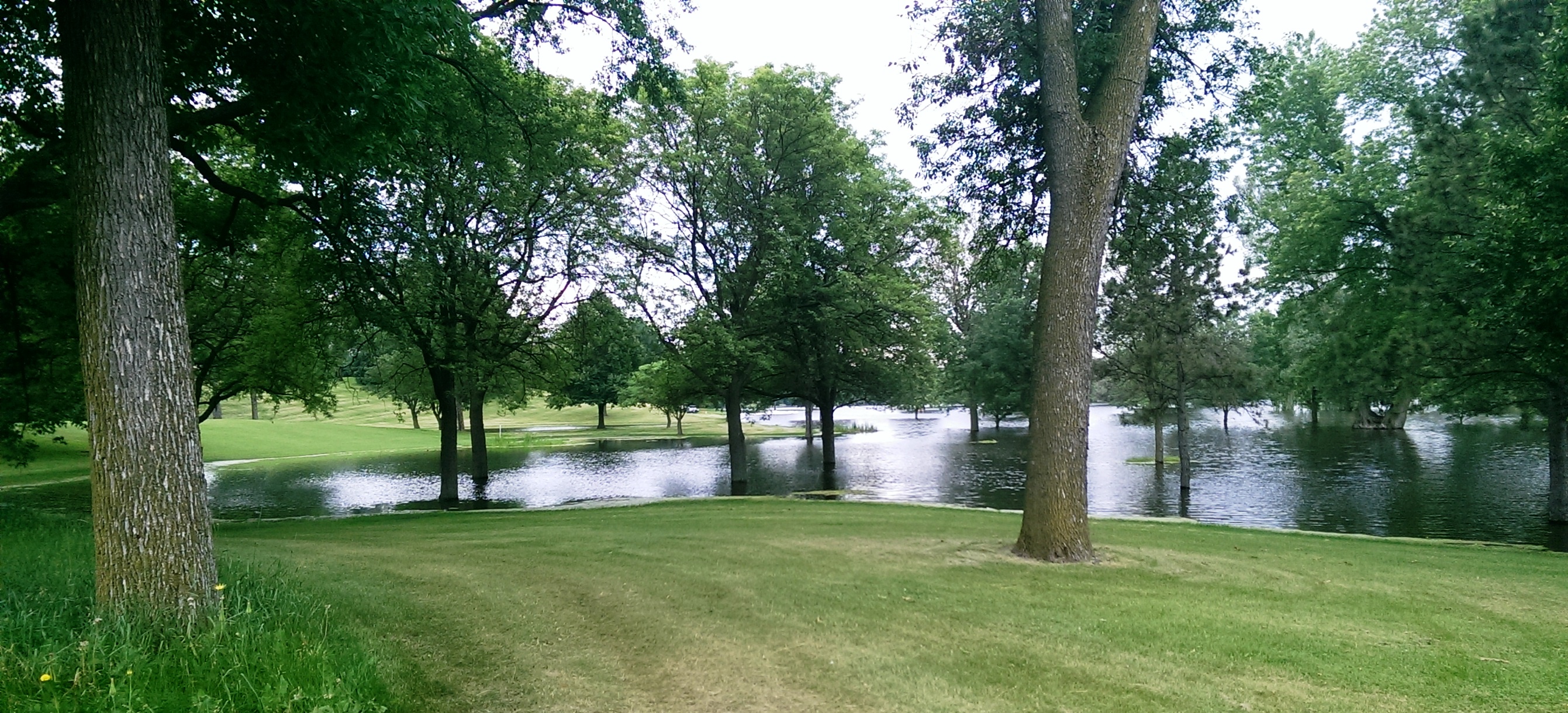
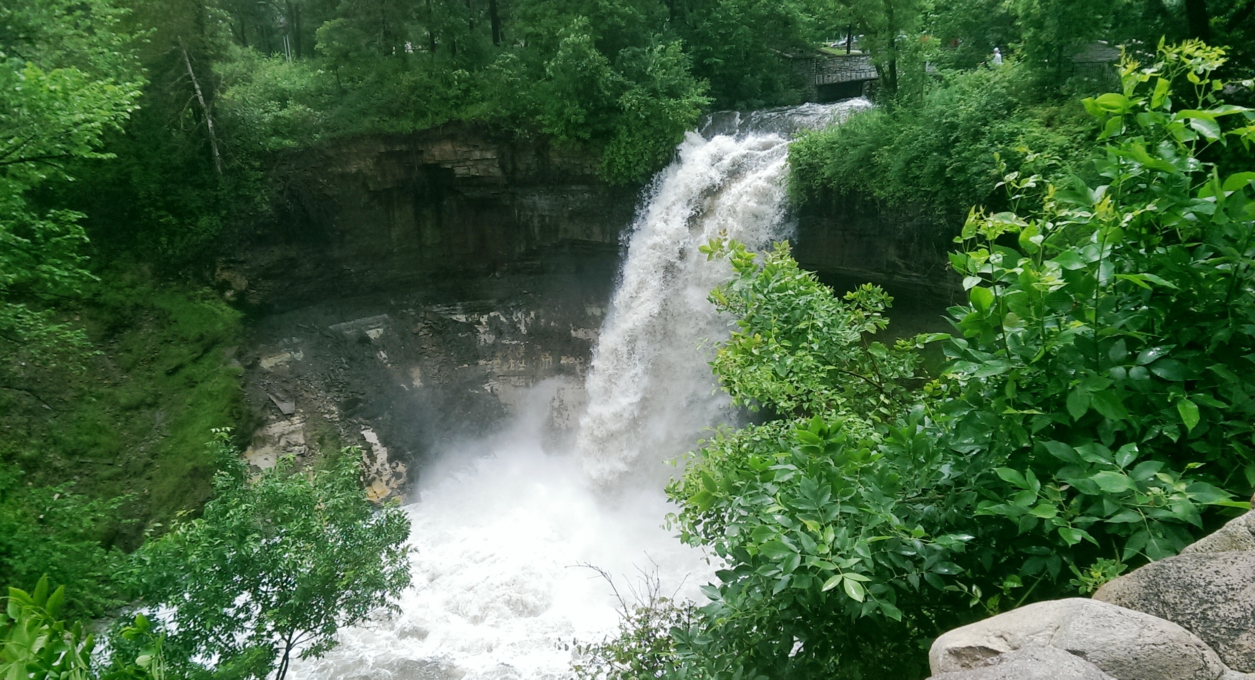
The Last of the Deluge: Minnehaha Creek Floods Meadowbrook Golf Course
Filed under: Minneapolis Golf Courses, Minneapolis parks, Minnehaha Creek | Tags: Hiawatha Golf Course, Meadowbrook Golf Course, Minnehaha Creek, Theodore Wirth Golf Course
Leave a Comment Ok, enough about flood waters—but I had to post a couple more shots of water winning. These were taken at Meadowbrook Golf Course, the Minneapolis park course located in St. Louis Park and Hopkins on Excelsior Boulevard. (Click here to learn why the Minneapolis Park Board owns a golf course outside city limits. In fact, it owns four courses outside of Minneapolis: Theodore Wirth, Francis A. Gross, Fort Snelling and Meadowbrook.)

Meadowbrook Lake! Meadowbrook Golf Course — seen here from Excelsior Boulevard in St Louis Park — usually doesn’t have a lake in the middle of it. A pond on Minnehaha Creek on the eastern edge of the course — several hundred yards from this scene — was created in the late 1920s shortly after the course opened, because high water in the creek flooded part of the course. The pond was dredged to hold potential flood water and the earth dredged for the pond was used to raise the level of the course around it. That has worked pretty well through the history of the course — but not when Minnehaha Creek rises this much. This photo was taken more than a week after the heavy rains of June 19. (David C. Smith)
Another shot of the new lake in Meadowbrook Golf Course taken from near Excelsior Boulevard. (David C. Smith)

A different “lake” view, this looking east from Meadowbrook Road through the heart of the golf course. The 14 water hazards the course normally features appear to have merged into one. (David C. Smith)
As of this afternoon, the only Minneapolis public courses that remain closed due to flooding are Meadowbrook and Hiawatha. Only this afternoon, Theodore Wirth began allowing the use of carts again. There is no target date for when the two closed courses will reopen, but it’s likely to be awhile—especially with another 2-4 inches of rain forecast for this weekend.
Not only will cleanup and repair of these courses be expensive, but the revenue they typically generate will be lost to the Park Board for much of the summer.
David C. Smith
© 2014 David C. Smith
Mississippi River flood
Filed under: Minneapolis parks, Minnehaha Creek, Minnehaha Falls, Mississippi River | Tags: Ford Dam, Minnehaha Falls, Mississippi River
Leave a Comment Saturday afternoon I spent a bit more time looking at high water around the city. On that gorgeous afternoon, Minneapolis parks were heavily patronized, partly because of the beautiful day and partly because people were curious about the effects of our summer deluge.
The banks of the Mississippi River that I helped clean in April were under water again. Maybe when these flood waters subside, Friends of the Mississippi River should sponsor another trash pick up. Or we could each take a trash bag along when we go out for riverside hikes.
More evidence of high water on the big creek at the Ford Dam.

High water over the Ford Dam, June 21, 2014. Late last summer, there was no water flowing over the dam and below the dam was mostly dry land. (David C. Smith)

Last summer you could walk from the locks to the island where the submerged trees are now. The Ford Dam is just to the left of this photo. (David C. Smith, June 21, 2014)
Both photos were taken from the bluff at Minnehaha Park and the Soldiers Home. Water levels in Minnehaha Creek had subsided little, if at all, from Thursday to Saturday. Water was still thundering over Minnehaha Falls.
David C. Smith
Minnehaha Falls and Creek: Flood Stage
Filed under: Minneapolis Lakes, Minneapolis parks, Minnehaha Creek, Minnehaha Falls | Tags: Hiawatha Golf Course, Minnehaha Creek, Minnehaha Falls, Minnehaha Parkway
Comments (10) As we await another early evening thunderstorm, I will post a few historic photos of Minnehaha Creek and Minnehaha Falls taken earlier this afternoon. I call them historic because I’ve never seen the creek this high. One man I encountered on my explorations claimed it was a record water level for the creek. I’ll have to look that up.
The entire length of the creek was flooded, of course, even a few hours after the rain had stopped, but these three photos establish landmarks.

The bridge to nowhere. The creek normally flows under the bridge near the top of the photo. Minnehaha Parkway at Humboldt Avenue South, south of the Lynnhurst Recreation Center. (David C. Smith)
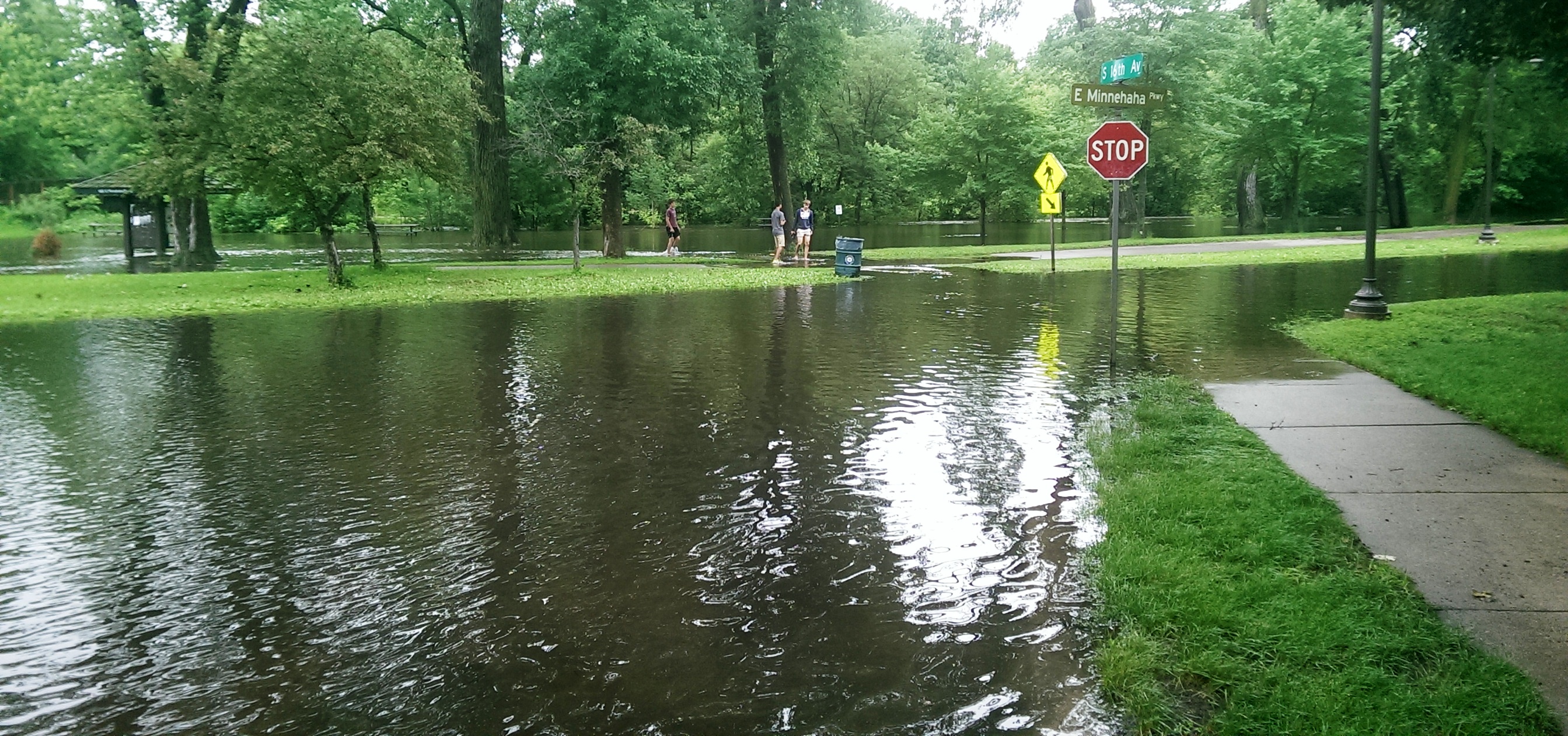
Minnehaha Parkway at 16th Avenue South. (David C. Smith)

Looking west on Minnehaha Parkway at Cedar Avenue South. (David C. Smith)
A man I met near Cedar Avenue claimed that the water reached a similar level after a 1988 thunderstorm, but the water subsided very quickly. Today it didn’t. Minnehaha Parkway was barricaded at many points east of Lake Harriet.

More than a water hazard. Hiawatha Golf Course looking south from E. 43rd Street near Standish. That is not Lake Hiawatha in the foreground. (David C. Smith)

A romantic interlude at the famous rapids of Minnehaha Creek! This is only a few yards upstream from the Hiawatha statue. (David C. Smith)
Some early descriptions of the Falls mentioned the heavy mist generated by the falls. That was true today. There was no rain falling while I was taking the pictures below, but I could feel the water in the air. Not quite as dramatic as Victoria Falls, where the cloud of mist over the falls is visible for miles — it’s called Mosi-o-Tunya, the Smoke that Thunders — but still impressive for this normally modest stream in mid-summer.
The falls made famous by Henry Wadsworth Longfellow. I recently discovered startling early plans for the park at the falls that I am waiting for permission to reveal. Stay tuned. (David C. Smith)
Unfortunately such high water levels, like the strong winds of recent years, require expensive cleanup efforts from the park board, stretching already tight park maintenance budgets. Kudos and thanks to the park board crews that will put our water-logged parks in beautiful condition yet again.
David C. Smith
© David C. Smith
Does anyone have any pictures to post of Bassett’s Creek in Theodore Wirth Park or downstream to Bryn Mawr before it dives underground? Is Shingle Creek any better?
Alice Dietz and Bea Dunlap in 1939 Playground Pageant
Filed under: Minneapolis Park Hero, Minneapolis Park Memory, Minneapolis Parks: General | Tags: Alice Dietz, Farview Park, Playground Pageants
Comments (3) I received this note and photo today from Bea Dunlap of Dallas, Texas, under the subject line, “Alice Dietz and me 75 years ago.”
“This picture was taken about 75 years ago (I am now 85 years old) when I was in a Park board pageant representing Farview Park. Me and almost ever kid in my block were Raindrops in a skit called Umbrella Man. The little ones were turtles who hid under a big umbrella until the “sun came out”. Our costumes were made of silver and blue crepe paper. My Mom sewed most of the costumes for our group.”
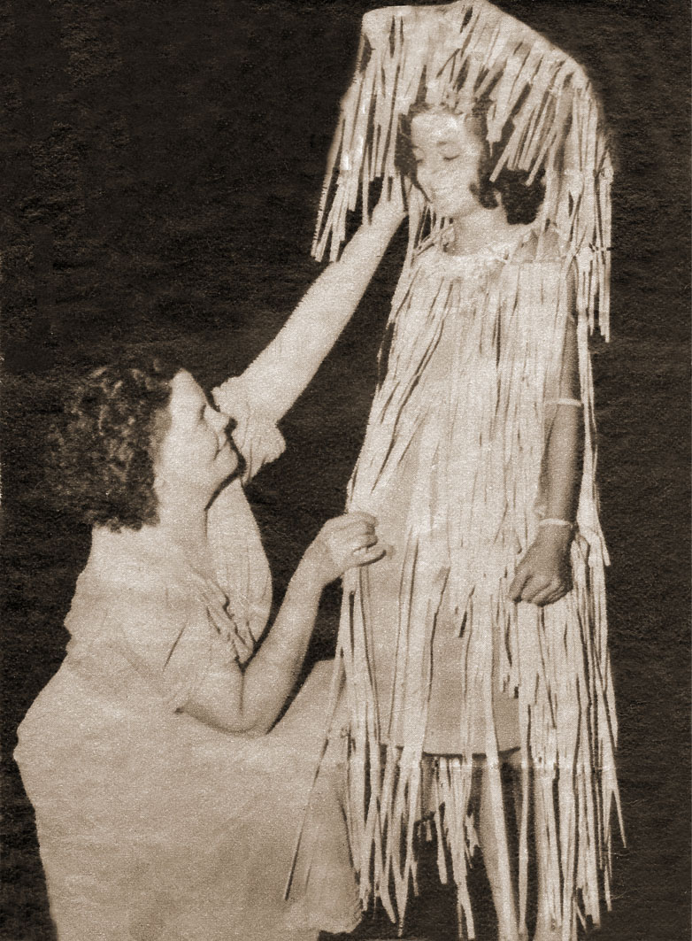
Alice Dietz, creator and director of the playground pageants, with ten-year-old Bea Dunlap from Farview Park in 1939. Bea is dressed as a raindrop. (Photo courtesy of Bea Dunlap.)
The playground pageants, held at the end of summer, included children from every park in Minneapolis. They were presented on the hillside above the Rose Garden at Lyndale Park. The pageants were created and directed by Alice Dietz. This was one of the last playground pageants. With the creation in 1940 of the Aquatennial, that became the focus of summer celebration in the city and the pageant was discontinued.
Thanks for the wonderful photo and information, Bea.
David C Smith
I Finally Made It!
Filed under: Minneapolis Parks: General, Tower Hill Park | Tags: Prospect Park, Tower Hill, Witch's Hat
Comments (6) I finally climbed the Witch’s Hat Tower in Tower Hill Park. The erstwhile water tower was completed in 1914 after the park was acquired by the Minneapolis Board of Park Commissioners. I have already written about the tower here and here and here. Today I’m just providing proof of my climb with photos and a few brief observations.
Most years the tower is only open one night a year, the night that Pratt School has its ice cream social, which was last Friday, but this year the tower will also be opened to celebrate the dedication of the tower 100 years ago. That will take place July 12 and 13. So you get an extra chance to see the view from the top this summer.

The view west toward downtown — and into the sun. Pratt School is at the bottom. I took the picture a little after 5 p.m. I didn’t have to wait in line to make the climb, but by the time I descended about 100 people were in line waiting their turn. (David C. Smith)
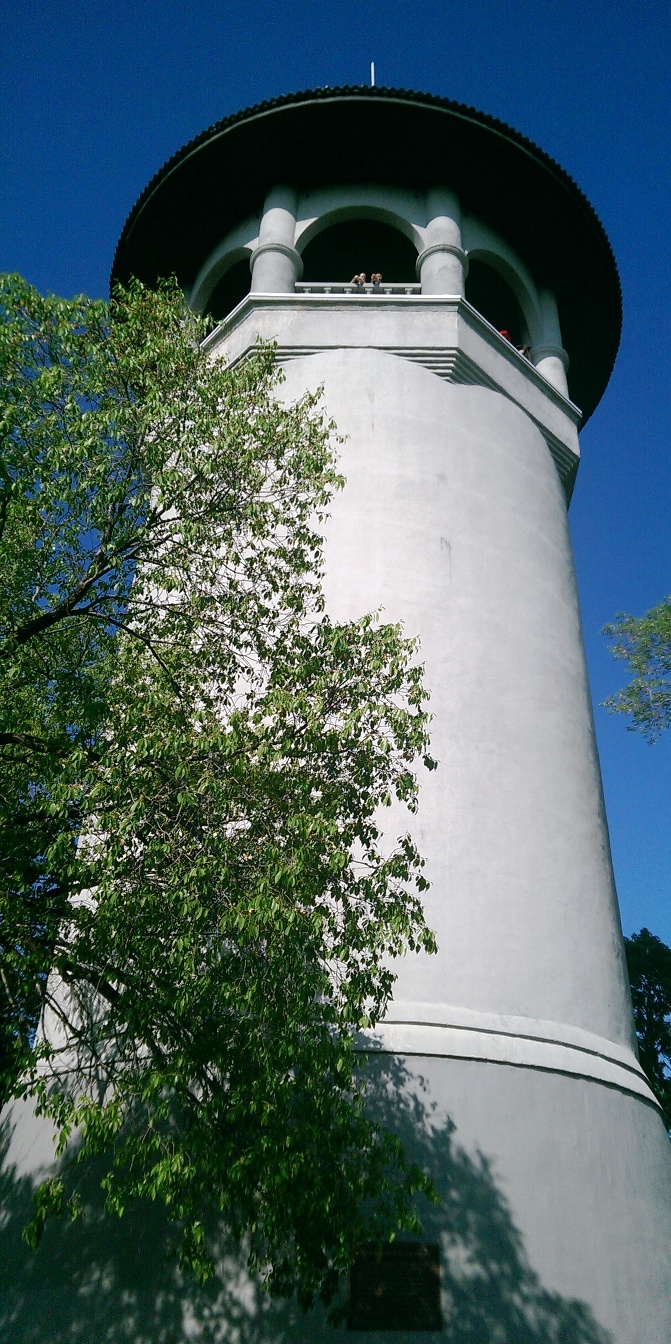
The Witch’s Hat from the terrace near the entrance to the tower. It was a perfect day for a view. It really is this white and sky really was this blue. My Dad, who turns 90 this year, chose not to climb the 100+ steps to the top of the tower, but still enjoyed the spectacular view from the terrace. Even if you miss the few chances to climb the tower, visit the park for beautiful views of the city. (David C. Smith)

The view from the Witch’s Hat to the southwest, across Prospect Park and the Mississippi River into South Minneapolis. This was my favorite view, in part, because of how well the Mississippi River is hidden. You can tell it’s there and you can see part of the railroad bridge over the river, but it is amazing how such a prominent and predominant geographical feature can be swallowed by the landscape. I couldn’t help but imagine the wildness of the view from here 150 years ago — before buildings and also before the Minneapolis park board planted hundreds of thousands of trees along city streets. Early writers note that what is now South Minneapolis, from the river gorge to the lakes in the southwestern part of the city, was mostly treeless prairie. The Tower Hill Park tennis courts are visible in the lower right corner. (David C. Smith)

The top of the stairs down the Witch’s Hat. (David C. Smith)

The spiral staircase of the Witch’s Hat. It was narrow enough that I had press up against the wall and suck in my (shrinking) stomach to pass people going the other way. The large deck at the top of the tower was intended to be a bandstand for concerts, but musicians had a difficult time getting their instruments up this narrow staircase. Imagine lugging a bass, bass drum or tuba up or down. But others were once able to enjoy the view any time. When the tower was first opened in 1914, the park board paid a park keeper to open the tower to the public five days a week. (David C. Smith)
If you took better photos than I did, please email them and I’ll post them here.
David C. Smith
© 2014 David C. Smith
Lake Harriet: The Heart of the Minneapolis Park System
Filed under: Lake Harriet, Lyndale Park, Minneapolis parks | Tags: H.W.S. Cleveland, Horace Cleveland, Lake Harriet, Lake Harriet Pavilion, Lyndale Park, William Berry Park
Comments (2) NOTE: The following outline and photos introduce the important role of Lake Harriet in the creation and growth of the Minneapolis park system. While much of this information is familiar to Minneapolis residents, I prepared this presentation for students visiting Minneapolis today from University of Wisconsin Eau Claire. I thought other readers of minneapolisparkhistory.com might enjoy the images and information as well. For more in-depth info visit the history pages of the Minneapolis Park and Recreation Board. For a more complete picture of the parks surrounding Lake Harriet see the history of Lake Harriet, but also of William Berry Park and Lyndale Park.
If the prized Minneapolis park system were a living thing, Lake Harriet would be its heart. The Grand Rounds — 60 miles of parkways threaded through the city — would be the rest of the circulatory system of veins and arteries. The analogy holds more for the creation of the park system, with parkways radiating out from Lake Harriet and back, than for the current function of Lake Harriet in the system.
Lake Harriet and Lake Calhoun had always been primary targets of people in Minneapolis and St. Anthony who believed the growing towns needed parks. For decades, residents of the small towns beside St. Anthony Falls had taken Sunday excursions to the shores of the lakes for picnics and relaxation. As early as 1869, the Board of Trade, a chamber-of-commerce type organization, had voted to acquire the shores of Lake Calhoun for a “pleasure drive” and had secured commitments from all landowners around the lake except one to donate their shoreline for that purpose. That one unnamed holdout must have torpedoed the entire plan.
When the Minneapolis park board was created by an act of the Minnesota Legislature and ratified by Minneapolis voters in 1883, it was well-understood that the lakes would become part of a new park system. Proof was easy: the legislature expanded the city limits of Minneapolis to include Lake Harriet at the same time it created the park board. One went with the other.
One of the park board’s first acts was to hire landscape architect and park advocate H. W. S. Cleveland to advise the board on the creation of parks. About a month later Cleveland presented his “Suggestions” to the broad for a new park system featuring interconnected parkways rather than just a couple large parks. The map that accompanied his suggestions, below, shows in red the parkways he recommended. Note that only Lake Harriet is fully encircled by parkway, the “heart” of this circulatory system.

Horace Cleveland proposed this system of parks and parkways in 1883. (Minneapolis Park and Recreation Board)
The map provided a blueprint for a park system that the park board tried to implement. Although the board failed to acquire many of the specific routes proposed by Cleveland — and added others — the concept of a system of parkways encircling the city eventually became the Grand Rounds parkway system of today.
Cleveland used another anatomical metaphor in the park system he proposed that focused on what was most important to him. He called the Mississippi River gorge and parkways on both sides the “lungs” of the city. He meant that a corridor of green on both sides of the river — the “jewel” of the city — would provide a flow of fresh air through the city north to south, which would help prevent pollution and disease. It was not a coinage that originated with Cleveland, but had been used to advocate city parks in the dense and squalid urban cores of Paris and London since early in the century.
In fact, however, the Grand Rounds parkway system had its start at Lake Harriet and the rest of the parkways followed. It was the first parkway the park board attempted to acquire. A first appraisal of the shores of the lake put the cost at $300,000, much more than the park board could legally spend. Then landowners Henry Beard, Charles Reeve and James Merritt approached park board president Charles Loring with an offer: they would donate to the park board a strip of land 125 feet wide that nearly encircled the lake. The park board gratefully accepted that offer in 1885. (Ownership of a portion of that land was being contested at the time in court and a court ruling returned much of the land to William S. King, then a park commissioner. He honored the deal already struck with the other landowners and the park board owned a strip of land for a parkway around most of the lake.)
The park board’s other parkway projects revolved primarily around creating routes from other parts of Minneapolis to Lake Harriet. Hennepin Avenue was acquired to be a parkway connection from Central (Loring) Park to Lake Harriet. But when heavy traffic on that road dimmed its prospects for ever being a parkway, an alternative route to Harriet was found. Land was donated for Kenwood Parkway from Central Park to Lake of the Isles, then around Lake of the Isles, which hadn’t figured at all in Cleveland’s plan, to Lake Calhoun. The park board purchased the eastern shore of Lake Calhoun, at what Loring considered an exorbitant but necessary price, to reach the southern tip of Lake Calhoun. From there, Linden Hills Boulevard, also acquired from Henry Beard, would carry traffic to Lake Harriet.
Cleveland conceived of another major circulatory connection to Lake Harriet as a parkway east from Lake Harriet to the Mississippi River. He envisioned that to be Lake Street, but that thoroughfare already was home to a concentration of businesses that made it too expensive to acquire. The route east from Harriet that later emerged, largely due to free land, was Minnehaha Creek. Although much farther south and far from the central city neighborhoods that Cleveland thought would need a parkway, Minnehaha Parkway became the park connection to Minnehaha Falls and the river parkways.
Even the parkways from the Lake District into north Minneapolis were really arteries directly from the north side to Lake Harriet. When it became evident that Lyndale Avenue could not be converted into a parkway from Central Park north, the park board looked to the west to connect Lake Harriet via Cedar Lake and what eventually became Theodore Wirth Park and Parkway to north Minneapolis. Once again the appeal, at first, was the prospect of free land along that route from William McNair, a friend of the parks and several park commissioners.
Further supporting the Lake Harriet-as-heart metaphor is that the northern half of the Grand Rounds was inspired by what had already occurred in the southern half of the city connecting lakes, river, and creek to Lake Harriet. William Folwell, former University of Minnesota president, park commissioner and Cleveland’s close friend, urged the park board in a special report at the end of 1890 to return to the vision of Cleveland. In his report, he urged the board to resurrect and finish the system of parkways throughout the city that Cleveland had suggested. Folwell even gave that system of parkways, which began and ended at Lake Harriet, a name for the first time: Grand Rounds.
To the Water’s Edge
The parkway at Lake Harriet also established another critical precedent in the history of Minneapolis parks. In keeping with Cleveland’s plan for an interconnected system of parkways, the park board wanted a parkway around the lake instead of just a large park beside it. The parkway acquired encircled the lake on its shoreline. That meant the park board owned the entire lake and it established that precedent for later acquisitions at Lake of Isles, Lake Calhoun, Minnehaha Creek, even the Mississippi River gorge. Nearly everywhere in Minneapolis, the park board owns the water front. The only places that is not true today is the banks of the Mississippi River above the falls, and that is in the process of being acquired piece by piece, and those parts of Bassett’s Creek that had been tunneled below ground even before the park board was created.
The unique and defining feature of Minneapolis today is not only the lakes and creeks and river running through it, but that almost all land abutting those bodies of water is publicly owned and preserved as parkland. We aren’t restricted to a glimpse of water between mansions built on lakeshores; the people own the lake shores. The effect on the prosperity of the city has always been significant. As Minneapolis park board studies have shown, property values are increased not only adjacent to the lakes, creeks and river but up to several blocks away from those amenities because they are publicly owned and freely accessible.
Donation of Land
Another reason for the centrality of Lake Harriet to the development of the Minneapolis park system was the means by which the park board acquired the Lake Harriet shoreline: it was donated. That also established a precedent that Charles Loring, in particular, was very successful in replicating. Loring secured other land donations in the few years after the donations at Lake Harriet by Beard, Reeve, Merritt and King: Kenwood Parkway, most of Lake of the Isles, half of Lake Calhoun, part of Cedar Lake, much of Minnehaha Creek, Stinson Parkway, Lyndale Park and The Parade. Even much of the river gorge was sold to the park board well below market value.
Let Us Entertain You
Lake Harriet was also the heart of park board expansion into new areas, especially providing entertainment and recreation. Entertainment at the lake began at a pavilion built by the street railway company on private land beside the lake, but became one of the most popular destinations in the city after the park board allowed the street railway company to build a pavilion on the shores of the lake in 1892. The park board didn’t provide the entertainment directly, but did exercise considerable control over the types of entertainment the railway company was allowed to present. That entertainment did not always meet the approval of all park commissioners, but it continued because people liked it and turned out by the thousands. It is one of the first examples of the nature of parks being adapted to what people wanted.

The first pavilion built on the Lake Harriet shoreline in 1892. The pavilion was designed by Harry Wild Jones. This view is from the streetcar station in about 1895. (Minnesota Historical Society.)
Another important attraction at the Lake Harriet Pavilion were row boats. One of the donors of land around the lake, Charles Reeve, offered in 1887 to pay the park board $1,000 for the right to rent boats and sell refreshments at the lake. Competitive bidding pushed the price up to $1,250, a large sum in the day, before Reeve gained concession rights. But by 1889 the park board realized it could make a nice profit running the boat and refreshment concessions itself and purchased Reeve’s boats.

The park board’s boats for rent next to the Lake Harriet pavilion in 1895. (Minnesota Historical Society)

When the first lakeside pavilion burned down, it was replaced by another Harry Wild Jones-designed structure that extended into the lake in 1904. At the new pavilion, musical performances took place on the roof. The bandshell pictured had terrible acoustics and was replaced after one year. The bandstand was moved to the east side of the lake at 46th Street as a lookout. The boat rental business continued to thrive. (Minnesota Historical Society)

View from the bandstand on top of the Lake Harriet Pavilion in 1905. Notice how far down the shore the boat dock stretches. A seat on the roof for a concert cost 25 cents. (Minnesota Historical Society)

The crowd at a concert on the pavilion roof in 1912, photographed from the stage. (Charles J. Hibbard, Minnesota Historical Society)
The Bicycle Craze
Active recreation–physical exercise–began at Lake Harriet with boating and canoeing, but then along came the bicycle craze of the 1890s and the park board continued what has become a long tradition of accommodating what people wanted from their parks.
Bicycling was so popular that the park board built a bicycle path around the lake in 1896. So many people rode bicycles to the lake that the park board built an enclosure where people could check their bicycles while they were at the pavilion or renting a boat. It was built to hold 800 bicycles. Soon after, the park board built bicycle trails along Minnehaha Creek as well.

One of my favorite Minneapolis park photos shows the bicycle path around Lake Harriet in 1896. This was the first bicycle path in Minneapolis. The layout of walking path, bicycle path and carriage road is almost identical to today. (Minneapolis Park and Recreation Board)
These are just the beginning of the accommodation of public desires at Lake Harriet and then other park properties. What began at Lake Harriet, like the parkways radiating out from it, quickly extended to other parts of the park system even as new amenities were added at Lake Harriet. From the picnic shelter at Beard Plaisance on the west side of the lake in 1904 to the Rose Garden created on the east side of the lake in 1907, the throngs drawn to the lake were regularly provided new attractions.
David C. Smith
© 2014 David C. Smith
Horace Cleveland Gets a Park!
Filed under: Minneapolis Parks: General | Tags: H.W.S. Cleveland, Horace Cleveland, Mississippi River Gorge
Comments (1) It could finally happen! I was delighted to learn that Minneapolis Park Commissioners Scott Vreeland and Steffanie Musich will introduce to the board this week a formal proposal to name all or part of the Mississippi River gorge in Minneapolis after Horace William Shaler Cleveland. He was the landscape architect who was so influential in the creation of the Minneapolis and St. Paul park systems and, especially, the protection and preservation of the incomparable river gorge as a park.

The cover of the park board’s 1905 annual report shows the Mississippi River gorge looking up river from the mouth of Minnehaha Creek at left. (Minneapolis Park and Recreation Board)
I can think of no higher or more appropriate honor for a man whose vision meant so much to life in this metropolis than to name this magnificent ribbon of untrammeled, still-wild green in his name.
Scott Vreeland has pointed out that the proposal he will read this week is only the beginning of the process that must gain approval now from many jurisdictions, from the Minneapolis Park and Recreation Board to the National Park Service. Perhaps it is indicative of Cleveland’s profound legacy that local, regional, state and national entities are now involved in the continued preservation and administration of the treasure the river gorge has become.
But it is a start. To read more about why I believe this is important, read my earlier articles here and here. Or click on Cleveland’s name in the tag cloud at right to learn a great deal more about this extraordinary person.
Thanks Scott and Steffanie for taking this step.
I hope all other organizations, public and private, that are interested in the river will support them.
David C. Smith
© 2014 David C. Smith
Witch’s Hat Centennial at Tower Hill
Filed under: Tower Hill Park | Tags: Frederick W. Cappelen, Prospect Park, Tower Hill Park, Witch's Hat
Comments (3) 
The above image, a poster from the 60-year anniversary of the construction of the Witch’s Hat on Tower Hill, was sent to me by a reader in the Netherlands. The top is apparently from Frederick W. Cappelen’s original design for the tower in 1913. The bottom is a groovy, so ’70s, panorama of Tower Hill.
My correspondent from the Netherlands, who spent part of his youth in Prospect Park, wanted to know if a poster had been created for the centennial of the tower.
I’m happy to report that plans are in the works for a poster and a t-shirt featuring the tower. Joe Ring informs me that because the official dedication of the tower didn’t take place until the summer of 1914, even though construction began in 1913, the neighborhood is holding the centennial this year instead of last year.
So it looks like we may have two opportunities to climb the tower this summer and see what has to be the grandest panorama available in these parts.
Pratt School, across the street from the park, is having its annual ice cream social May 30, 5-8 p.m.. That is typically the only day of the year when the tower is opened to the public. So enjoy some ice cream, listen to some music and climb the tower that night.
But Joe informs me that the tower will be open for its centennial celebration on July 12 and 13, as well, with another concert planned for July 15. Definitely more dates to put on your summer calendar.
David C. Smith
© 2014 David C. Smith

